![]()
Prepared for
The Department of Prime Minister and Cabinet
ABN: 18 108 001 191 2
Heritage Management Plan – Volume 2
Kirribilli House and Garden, Kirribilli, NSW
13-Nov-2023
Kirribilli House HMP Update
Doc No. FINAL
![]()
Prepared for
The Department of Prime Minister and Cabinet
ABN: 18 108 001 191 2
Heritage Management Plan – Volume 2
Kirribilli House and Garden, Kirribilli, NSW
13-Nov-2023
Kirribilli House HMP Update
Doc No. FINAL
Kirribilli House, Kirribilli, NSW
Client: The Department of Prime Minister and Cabinet
ABN: 18 108 001 191 2
13-Nov-2023
AECOM in Australia and New Zealand is certified to ISO9001, ISO14001 and ISO45001.
© (AECOM). All rights reserved.
AECOM has prepared this document for the sole use of the Client and for a specific purpose, each as expressly stated in the document. No other party should rely on this document without the prior written consent of AECOM. AECOM undertakes no duty, nor accepts any responsibility, to any third party who may rely upon or use this document. This document has been prepared based on the Client’s description of its requirements and AECOM’s experience, having regard to assumptions that AECOM can reasonably be expected to make in accordance with sound professional principles. AECOM may also have relied upon information provided by the Client and other third parties to prepare this document, some of which may not have been verified. Subject to the above conditions, this document may be transmitted, reproduced or disseminated only in its entirety.
Document | Heritage Management Plan - Volume 2 |
Ref | l:\secure\groups\!env\team_iap\archaeology & heritage\proposals & projects without apic numbers\2023_05_10 kirribilli hmp\third draft hmp 20231113 public version\updated 2025\20250131 kirribilli house hmp vol 2 draft.docx |
Date | 13-Nov-2023 |
Originator | Redacted for public exhibition |
Checker/s | Redacted for public exhibition |
Verifier/s | Redacted for public exhibition |
Revision Date | Details | Approved | ||
Name/Position | Signature | |||
A | 20-Jun-2023 | Draft | Redacted for public exhibition |
|
B | 18-Oct-2023 | Draft | Redacted for public exhibition |
|
C | 13-Nov-2023 | Final | Redacted for public exhibition |
|
|
|
|
|
|
This document includes professional services that require approval from a registered professional.
Discipline / | Name of Registered Professional* | Signature | Registration No. | Date | |
NSW Board of Architects | Heritage | Redacted for public exhibition |
| Redacted for public exhibition | 21/06/2023 |
|
|
|
|
|
|
|
|
|
|
|
|
|
|
|
|
|
|
* The registered professional must be the originator of this work or have provided direct supervision to the originator.
APPENDIX A
APPENDIX B
Historical Background
APPENDIX C
Australian Prime Ministers 1901
APPENDIX D
Historical Summaries
APPENDIX E
Timeline -1794 – 1957 by Rosemary Annable
APPENDIX F
Owners and occupiers 1806 – 2023
APPENDIX G
Recent schedule of works 1978 – 2023
APPENDIX H
Physical survey/Fabric survey – Kirribilli House
APPENDIX I
Tree Survey by AECOM, 2023
APPENDIX J
Assessment of Indigenous Heritage Values by AECOM, 2023
APPENDIX K
Landscape Management Plan by Taylor Brammer, 2020
APPENDIX L
Non-Indigenous Archaeological Assessment by Casey & Lowe, 2010
APPENDIX M
Evolution plans, by Design 5, 2010
APPENDIX N
Kirribilli Bathing Pool by Grace Karskens, 1987
APPENDIX O
Colour palette and interior design by GML, 2014
APPENDIX P
Heritage Induction Training Materials (Including Dos and Don’t Handbook), AECOM, 2023
Appendix Q
Assessment of NSW State Heritage and National Heritage assessment criteria
The historical background of Kirribilli House has been thoroughly researched by previous assessments. A chronological history was undertaken by Dr Grace Karskens, Catherine Forbes and Brendan Lennard as part of the “Kirribilli House, Conservation Analysis and Draft Conservation Policy” (November 1985), prepared by Clive Lucas & Partners. In addition, consultant historian, Dr Rosemary Annable, conducted additional research on the early European history of the site for the draft CMP in 2010 by Design 5 Architects.
The following historical background is based on Dr Annable’s research as presented in Appendix B2 of GML Heritage’s 2016 HMP. Dr Annable’s reports are included in Appendices E-G. AECOM findings from additional research has also been included.
Both Dr Annable and GML Heritage list the sources of documentary evidence used in their reports. In updating this report, where possible, documentary sources used in previous reports such as photographs, drawings, maps, and plans, have been verified/augmented from the following documentary sources:
The following history of the place was prepared by Dr Rosemary Annable as part of the historical research carried out for the Design 5 Architects 2010 draft HMP and was reproduced in the 2016 GML Heritage HMP. The text has been reviewed by AECOM and updated for any errors or omissions and knowledge gaps.
Within a few years of European settlement at Sydney Cove small grants of land were being taken up on the opposite side of the harbour at what became known as the North Shore. In 1800, Robert Ryan was granted 120 acres by Governor Hunter between the head of Hulk Bay and the head of Careening Cove, an area that incorporated an early grant to Samuel Lightfoot made in 1794.[1]
By 1806, Ryan’s land had been acquired by Robert Campbell who saw the area as a useful adjunct to his ship-building and mercantile interests at Sydney Cove and it remained in Campbell’s ownership for the next forty years until his death in 1846.[2]
Campbell’s first tenant was James Milsom, who built a house and ran a small farm and was, for some twenty years, the main occupant of the area.[3] From the late 1830s, however, as the property became more valuable for residential use than for farming or ship building, Robert Campbell began to lease parts of his land on the North Shore in smaller portions of a few acres. Many of these had desirable harbour frontages that not only provided views but also the easiest means of accessing the sites, by water.
In May 1842, Campbell leased five acres with a water frontage to Lieutenant Colonel John George Nathaniel Gibbes, Collector of Customs, for a period of twenty-one years, with the promise of the payment by Campbell of up to £500 at the end of that period (subsequently increased to £800) for any improvements made by Gibbes.[4] It was here at ‘Carrabella (Kirribilli) Point’, that Gibbes built the house that he called “Watonga”, later to become Admiralty House (Figure 1‑1).
Figure 1‑1: ‘“Wattonga” J LTravers Esq., Sept. 1855’, Rebecca Martens (Source: State Library of NSW, Call numbers DL PX 37/5)
Between 1830 and 1870s, the North Shore area was a popular location for residential development. The number of free settlers and emancipists were growing and access to the North Shore was limited to those who could employ licensed watermen and have access to their own boats and landing. The residents of the North Shore could enjoy the clean air, seclusion and harbour views and were protected from the crowds of the Sydney town. Residential development began in Neutral Bay in the early 1830s with ‘Craignathan’ ‘Thrupps cottage’ and Clee Villa’. In the 1850s houses included ‘Wallaringa’ (W. Dymock), ‘The Monastery’ (R.P Abbott), ‘Kurrabba House’ (Mr Jarrett), ‘The Dingle’ (Mr Grundy) and ‘Euroka/Graythwaite’ (Edwin Sayer). Houses on Kirribilli Point in the 1850s and 1860s included ‘Sunnyside/Wyreepi’ (Robert Hunt, Deputy Master for the Royal Mint), ‘Holbrook’ (Mr G M Pitt, of Pitt, son and Badgery). ‘Greenmount’ (William Tucker, wine merchant) and ‘Woodlands/Theluda’ ( H. H. Beauchamp) (GML Heritage Pty Ltd, 1993:32-22).
Gibbes’ financial affairs became precarious later in the 1840s[5] as did those of Robert Campbell’s heirs, his sons Robert and John, who had to offer the five acres that their father had leased to Gibbes as security to the Union Bank of Australia to cover two bills of exchange. When the bank needed payment in June 1849, it sold the land to the lessee and occupant, J G N Gibbes (Figure 1‑2) for £700 to set against Robert and John Campbell’s debt.[6] After acquiring the title to his house and land at modest cost, Gibbes immediately mortgaged the property and eventually sold it, still mortgaged, to James Lindsay Travers (a merchant) in December 1851.[7]
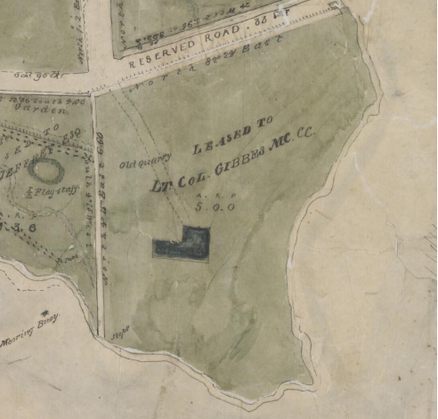
Figure 1‑2: Detail of 1840s map, “Campbell’s Estate”, showing the land leased to Lt Col Gibbes, and the outline of “Wattonga” (marked on map as ‘New House”) (Source: Trove, Ferguson Rare Map Collection, Map F 903)
In September 1854, Travers sold 1 acre and 23 perches of land at the north-east corner of his Carrabella Point estate to fellow merchant Adolph Frederic Feez for £200.[8] A native of the Kingdom of Bavaria, Feez had arrived in Sydney in 1851 and in February 1854, then aged 28, had become a naturalised citizen, making him eligible to hold freehold land in the Colony.[9] He and Travers shared the same business address at 10 Macquarie Place in Sydney and had presumably become acquainted through mercantile interests.[10]
Feez named the property ‘Sophienberg’ and between September 1854 and mid-1857 built a house, although the exact date is not known. Plans of Travers’ property drawn in June 1856 describe the area as “Mr Feez’s land” and how only fencing, a jetty and other structures on the waterfront, but no buildings, suggesting that construction had not yet begun.[11] The top of the house is visible, however, above Wotonga, in a sketch by Conrad Marten of Kirribilli Point viewed from the south side of the harbour, dated 5 June 1857.[12]
Access by water was essential for these properties and the construction of a jetty and boat house would have been a prerequisite for any occupation, including landing materials for building. Adolph Feez was already living on the North Shore when he purchased the land in 1854 and it is possible that this was intended as an investment property rather than to provide him with his own home.[13]
The boat harbour, boatshed and bathing pool in particular also reflects the recreational activities that were popular at the time and reflects the historical theme of The Pleasures of the People-Society, Culture and Entertainment identified in the thematic histories of the North Shore (GML Heritage Pty Ltd, 1993:125)
B-3.5 The Lawry/Taylor Family Home 1858-1908
Early in 1858 Mr Feez’s property, now complete with house, was put up for sale and on 1 March 1858 was purchased by Mrs Esther Hughes, widow of John Terry Hughes, for £3,000.[14] It seems likely that Mrs Hughes was purchasing the house for her daughter, Esther Matilda Hosking Hughes, in anticipation of her intended marriage to Thomas Lawry. Esther was underage when she married and while Mr Lawry was a clerk in the Ordnance Department on a salary of £450 a year, Esther had considerable property in her own right, bequeathed to her by her grandfather Samuel Terry.[15] With the permission of the Equity Court, Esther’s inheritance was the subject of a settlement formalised on 25 Mach 1858, the day of her marriage to Thomas Lawry. Under the terms of this settlement, the income from these properties was held by trustees for Esther and for any children of her marriage.[16]
From 1858 until 1908 the property that Adolph Feez had named Sophienberg, and later known as Kirribilli and Kirribilli House, was held in trust for Esther Matilda Hosking Hughes and her children and was their family home. Esther was married twice: first to Thomas Lawry, from 1858 until his death in August 1865 and, after a comparatively short widowhood, to James Taylor of the firm of L Sharwood & Co., importers, from March 1867 until his death in 1891.[17]
Esther and Thomas Lawry had two children, Esther Mary Trewyn Lawry born in December 1859 and Thomas Terry Trewyn Lawry born in March 1864.[18] Two stereo photographs, taken by William Hetzer in the period 1858-1863 show the harbour foreshore of Sophienberg and part of its gardens and grounds.[19] If the man, woman and child in the photograph of the house and garden are a family group, as seems likely, then this must be Thomas and Esther Lawry and their young daughter Esther (Figure 1‑3).
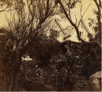
Figure 1‑3: One half of stereographic photograph of Kirribilli House & Garden, by William Hetzer, c. 1860-1863. A man, woman and child can be seen sitting on the grass behind a tree at left (Source: Powerhouse Museum, Call number 87/1019-15)
In 1860, Thomas Lawry purchased another piece of Campbell property, an area of 3 acres, 18 perches, immediately to the north of Sophienberg, on the northern side of Campbell Street. This land, bounded on the west by Carabella Street, added considerably to the family’s waterfront holdings and was separated from the family home only by the line of Campbell Street, which at this date seems to have been a street in name only.
Thomas Lawry ‘of Sophienberg, North Shore’ died in August 1865 aged 44 at his mother-in-law’s home, Albion House.[20] He had become a Justice of the Peace and Magistrate and by the time of his death, had relinquished his employment at the Ordnance Department.
It is not clear from street directories (the only source of information about place of residence at this date) whether Esther Lawry continued to live at Sophienberg after she was widowed, although she definitely lived in the area. Her future husband, James Taylor, was listed as resident at Kirribilli House in 1865 and 1866 and it is possible that the house was leased to him. What is evident is that Esther Lawry and James Taylor were neighbours at this period and that following their marriage, Kirribilli House was again Esther Lawry’s (Esther Taylor’s) home after their marriage in March 1867.[21] By this time the name Sophienberg had ceased to be used and the property was variously listed in street directories as Kirribilli House or just Kirribilli.
The marriage of James and Esther Taylor produced no children. Thomas Lawry’s children were aged three and seven when their mother remarried but they did not take their stepfather’s name of Taylor and retained the surname Lawry.
Evidence from the St Leonards Municipal rate books suggests two phases of change in the house and its ancillary buildings, in 1878-1879 and in 1883-1884.[22] In 1878-1879 buildings were erected on the land to the north of the house that Thomas Lawry had purchased in 1860. This was not separately itemised and rated at £30 as ‘Garden, stables etc.’ or ‘Fenced land, stables, etc.’ The 1891 detail survey shows three substantial structures on the land, two of them close to the entrance to the property which was directly opposite the entrance to Kirribilli House.[23]
A change in the assessed value of the house from £220 to £300 in the period from 1883-1884, suggests a substantial addition to the domestic accommodation. By this date, the two Lawry children were adults but unmarried and it is possible that this addition was to provide appropriate room for two more adults. As an unmarried daughter, Esther no doubt continued to live permanently at home and while her brother Tom had a property at Vermont, Cobbity, his keen interest in ‘aquatics’ no doubt saw him making good use of the boat houses and jetty at Kirribilli House.[24]
The extent of the house is shown in the 1891 survey and in the rate books is variously described as having 13 or 14 rooms. Following the death of her husband, James, in 1891, Esther Taylor continued to live at Kirribilli until her own death in 1900.[25]

Figure 1‑4: Detail of Parish of Willoughby map, c. 1899 showing Kirribilli as “Kiarabilli Point”. Location of Kirribilli House and grounds is marked in red (Historical Land Records Viewer, File Name 14019101.jp2)
In 1901 her children, Thomas and Esther Lawry, agreed to divide between them the property that was held in trust for them according to their mother’s marriage settlement, including the properties at Kirribilli. Tom took the house and Esther the land on the north side of Campbell Street that their father had purchased in 1860.[26] In the same year, Esther, then aged 42, married William Plunkett and moved to her own marital home. A photograph of Kirribilli taken by W H Davis between 1900 and 1902 shows the house and possibly its occupant, Tom Lawry, perhaps with members of his household.[27]
Tom, who never married, continued to live in the family home until his death in September 1907 aged 42. It seems he had continued to have an interest in ‘aquatics’; he bequeathed his boats and motor launches to his friends.[28] His sister, Mrs Plunkett, died the following year, aged 49, ending the fifty-year association of the Lawry/Taylor family with Kirribilli House. In 1909 her land, on the north side of Campbell Street, was subdivided and sold, thereby separated from the Kirribilli House property.
According to the terms of Tom Lawry’s will, the major beneficiary following his sister Esther’s death was Miss Laura Lamont (Lamotte) who inherited a life interest in his furniture and effects, an income from his properties and a life tenancy of Kirribilli House.[29] Laura initially lived at Kirribilli House, which she rented at a nominal rent agreed to by the trustees and it became her marital home following her marriage in 1909 to William Donald McCrea.
Figure 1‑5: Detail of subdivision map for the Kirribilli Estate, c. 1909 showing Kirribilli House (Source: State Library of NSW, Call number Z/SP/K7, SP/K7).
By 1913, however, she wished to move, and the trustees of the Lawry estate petitioned the Equity Court to allow them to let the house for a reasonable length of time, to obtain a tenant. The petition was not supported by Mrs McCrea and so her life interest prevailed, and the petition was disallowed by the Court.[30] Meanwhile, Laura and her husband vacated Kirribilli House anyway. The contents of the house were auctioned in July 1913, and the house was then tenanted, presumably on short-term leases.[31] An album of photographs of both interior and exterior views of the house at this period may have been taken for the purposes of the auction.[32]
Following the departure of Laura and William McCrea, the house was occupied by Arthur Pittar, a dentist (listed in Sands Directory in 1915-1918) followed by Michael Minnett (listed in Sands Directory in 1919 and 1920), the head gardener at Admiralty House. Sands Directory (which was frequently out of date) may have been incorrect about the length of Minnett’s occupancy as the house had not been occupied for some time and was “…in a very dilapidated state” when it went for auction in January 1920.[33]
In 1918, another suit in the Equity Court was more successful, when Laura McCrea petitioned to sell the Lawry trust properties including Kirribilli, which by now was costing more in upkeep than it raised in rent.[34] The sale was ordered by the Court in December 1918 and in June 1919 Kirribilli House was sold to A W Allen for £10,000. The property was advertised as having an unequalled position on the harbour front for “…a site for a large residence, for flats, or public buildings, or would subdivide to advantage”.[35]
Allen’s purchase had been purely an investment and six months later the house and land were again offered for sale, this time divided into five lots (Figure 1‑6) .[36] The site was indeed a very desirable one, and it seemed that the house would inevitably be demolished. Photographs of the apparently intact house and garden in the sale brochure contrasted with those in the newspapers, which showed that tree felling had already begun in advance of the auction,[37] increasing public concern that that the site was to be cleared for the construction of residential flats.[38] An inscription “H L M 1820” was found on a large rock when clearing the land on the waterfront.[39]

Figure 1‑6: Kirribilli House Subdivision Plan, 1920 (State Library of New South Wales, Ref Z/SP/K7/8)
There was little comment on the historical value of the property, but opposition to the sale centred largely on it being the only remaining piece of waterfront land that could be useful for public purposes. Headed by the People’s Open Air Space Movement, there was much agitation for the retention of the site for public purposes, while a number of ‘public spirited persons’, including Senator Pratten, Dr Mary Booth, Mr Sydney Smith and the Mayor of North Sydney waited upon the Minister for the Navy, Sir Joseph Cook, to encourage him to place the matter before the Federal Government.[40] A few days later, a public meeting convened by Dr Mary Booth, decided to make a direct appeal to the Prime Minister.[41]
More pragmatically, from the government point of view, Admiralty House had been offered to the incoming Governor-General as his residence when in Sydney and its amenity and value would have been seriously eroded by the construction of flats so close by. While the public protests gained publicity, it seems that it was the latter arguments that had some weight with the government.
The acting Prime Minister, Sir Joseph Cook, agreed to the purchase of the house for £12,000 (the Valuer-General’s valuation)[42] and when the offer was rejected by the vendor,[43] the house and land were resumed by the Commonwealth on the day of the auction sale ‘for defence purposes’ (Figure 1‑7).[44] As Minister for the Navy, Cook had thought that Kirribilli House might replace Tresco as the home of the officer in charge of Garden Island. However, by December 1920, the Cabinet had decided that both Admiralty House and Kirribilli House would be placed at the disposal of the Governor-General when in Sydney.[45] When the repairs to Kirribilli House were complete and Lord Forster, the new Governor-General, found that there was not enough accommodation at Admiralty House for his married daughter, whose husband was on his staff, Kirribilli House was accordingly taken up as part of the vice-regal establishment and Tresco remained the home of the Admiral.[46]
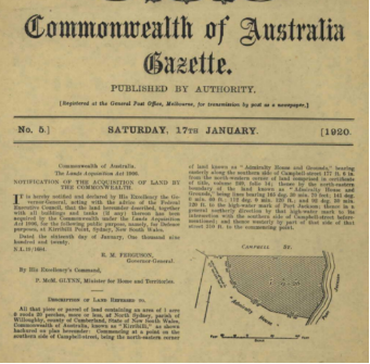
Figure 1‑7: Gazette Notice of resumption, Commonwealth of Australia Gazette, 17 January 1920, p. 1
From 1920 until 1930, Kirribilli House was used in conjunction with Admiralty House, to provide accommodation for the Governor-General’s staff, and in particular for the aides-de-camp. Plans for alterations and additions to the house drawn in January 1921 provided for a small addition to the west end bringing most of the service areas indoors, accessed either from within the house or from the porch on the west side. On the ground floor an office was provided for the aides-de-camp, with adjacent conservatory, and a servants’ hall, with bedrooms for the staff upstairs at the west end of the house.[47] The house was fully sewered, an amenity that it had not previously enjoyed and the whole of the exterior was painted white to conceal the difference between the existing stonework and the new brick addition.[48]
These alterations and additions were carried out by the Works Director in Sydney for the Commonwealth Works and Railways Department, which was also responsible for the choice of soft furnishing. In 1922, the Afforestation Branch in Canberra provided trees for Kirribilli House, where it seems, the grounds were cared for by the Head Gardener of Admiralty House, Mr Minnett.[49]
Both Lord Forster (Governor-General 1920-1925) and Lord Stonehaven (1925-1931) had several aides-de-camp. It is not known whether the house was used permanently by an aide-de-camp based in Sydney, or only during vice-regal visits to Admiralty House. According to an article in the Cairns Post, Lord Stonehaven used Kirribilli House for visitors and he frequently slept there himself, in preference to Admiralty House.[50]
By 1920, the two boat houses on the foreshore and the canopy over the bathing area were described as ‘…more or less dilapidated”, but the bathing area, jetty and retaining walls were still in reasonable repair.[51] These remained unused in 1920-1930, as similar facilities at Admiralty House were sufficient and so deteriorated even further.
In 1930, at a time of extreme economic stringency, the Commonwealth government decided to discontinue the use of Admiralty House and Kirribilli House by the Governor-General and to lease Kirribilli House.[52] The contents of the house were sold by public auction in November 1930.[53] Figure 1‑8 shows the site during the construction of the Harbour Bridge.

Figure 1‑8: Admiralty House (left) and Kirribilli House (right) during construction of the Sydney Harbour Bridge, c. 1930 (Source: Sydney Morning Herald, 26 March 1930, p. 18)
In October 1930, tenders were invited for the lease of Kirribilli House and in December 1930 the house was leased to Captain Albert Edwin Lundgren CBE, a Swedish shipping agent, for 400 guineas per annum for a period of three years plus an option of renewal for a further two years.[54] Captain Lundgren surrendered the term of his lease in February 1935 to Alfred House and when this ended, the house was vacated.
The expiration of the lease coincided with the government’s decision in 1936 to make Admiralty House available for the incoming Governor-General, Lord Gowrie, but Kirribilli House was not included in this arrangement. Instead, the house was renovated and once again put up for lease. Tenders to use it as a boarding house were rejected. Instead, it would be leased ‘…to some person of means who would be able to afford the rent of a home in such a locality’. Improvements prior to leasing included the installation of a hot water system, modernising one of the bathrooms and the installation of a gas stove.[55]
The new lessee was George Henry Deaton, of Deaton & Spencer, printers, and the rent was.[56] The grounds were ‘very neglected’ with many dead trees and shrubs. The flower borders were a mass of weedy growth, most of the grassed areas were Buffalo grass and the gravelled approach was also overgrown.[57] In 1939, damp was a problem. The cellar was full of water and expensive wallpaper was becoming discoloured and coming off the walls. Despite this, Mr Deaton was not keen to relinquish his lease and caused some embarrassment to the government when he refused to do so when preliminary discussions were in progress concerning accommodation for the Governor-General designate, HRH the Duke of Kent.[58]
In correspondence with the Australian government, concern had been expressed by the royal household about Kirribilli House being tenanted, but Mr Deaton was adamant that he would not move; and there was no provision for breaking the lease. With the outbreak of war late in 1939, the Duke of Kent did not take up the position of Governor-General and the problem was solved. Mr Deaton’s lack of co-operation may, however, have worked against him when he asked to surrender the lease in 1942 and was refused. With a sick wife and unable to secure any domestic help, Mr Deaton closed up the house in February 1942 and moved elsewhere. It was used for a month by the military, but then remained unoccupied until October 1943, when Mr Deaton transferred his lease to Commander Karl Erik Oom. A Naval officer and noted hydrographer, Commander Oom had recently been appointed officer-in-charge of the Hydrographic Branch in Sydney, responsible for survey operations in the South-West Pacific for which he won international recognition.[59] He continued to live at Kirribilli House until October 1953, by which time he had been invalided from the Navy.[60]
With Kirribilli House once more vacant, the question of its future use came under discussion. The Prime Minister, Robert Menzies, was reluctant to dispose of it and felt that any action to do so, ‘would meet with general disapproval particularly in New South Wales’. Moreover, the same arguments for its retention applied as in 1920, because when invited to be Governor-General, Sir William Slim had been told that Admiralty House would be made available to him. If Kirribilli House was sold, the land subdivided and flats built, then this would destroy the privacy of Admiralty House, and ‘…detract greatly from its value”.[61]
For their part, although Kirribilli House had not been made available for vice-regal use since 1930, success Governors-General had retained an interest in the house, had continued to ask (without success) for it to be made available for their personal or domestic staff and requested that they be kept informed of plans for its future.
In December 1953, M L Tyrell, official secretary to the Governor-General, wrote to the Secretary of the Prime Minister’s Department informing him that Sir William Slim wished to obtain permanent use of Kirribilli House and had had discussions with the Prime Minister on the topic. As Admiralty House was to be used more frequently over relatively longer periods of time, it was necessary to send almost all members of the Governor-General’s staff to Sydney.[62] Indeed, three or four members of staff were already living temporarily at Kirribilli House (an arrangement that continued intermittently until July 1955).
Early in 1954, the Department of Works reported on the building and in August the Ceremonial and Hospitality Officer of the Prime Minister’s Department, J H Scholtens, personally inspected Kirribilli House. Scholtens’ report was not encouraging. The grounds were shockingly neglected, the shrubbery growing wild, the lawns overgrown, paths cracked and the whole area “…in the grip of nature”. The state of the house was “…in complete harmony with the grounds”. With no damp course, damp, dry rot and a lack of general maintenance, his overall impression was “…a dirty, decayed, damp dwelling deserving destruction”.[63]
The Department of Works gave an estimate of £6,650 for the necessary works and pointed out that the layout for the house was unsuitable for domestic staff accommodation. Their report offered, however, another perspective; that once completely renovated, the house would offer accommodation, “…of which the official staff would be highly covetous”.[64] By October 1954, it had been decided that the house did indeed offer possibilities and in March 1955 approval was given for a private architect be engaged to prepare proposals for alterations to the house for the government’s consideration.[65]
The NSW Chapter of the Royal Australian Institute of Architects was invited to submit a panel of names and Mr J C Fowell of Fowell, Mansfield and Maclurcan was recommended.[66] It was, however, his partner, J C Mansfield, who was to become the designer and supervising architect of the project. Fowell Mansfield and Maclurcan’s drawings and report on proposed renovations and additions to Kirribilli House was completed in September 1955.
In light of the government’s brief that Kirribilli House would be restored ‘…to provide accommodation from time to time for distinguished visitors and guests of the government’, Mansfield’s proposal was a scheme that would allow Kirribilli House to be used either as two separate flats, or, on special occasions, as a whole. The ground floor flat would be suitable for use by the Prime Minister on visits to Sydney or for distinguished visitors, and the other flat for guests separately, or as overflow accommodation for either Admiralty House or the ground floor. The house had ‘…some historic interest and architectural character occupying a superb site on the harbour foreshore’ and would have “…a charm, individuality and local colour which would be greatly appreciated”. Its decoration and furnishings should be chosen, Mansfield suggested, “…to create an atmosphere of quiet distinction”. The major change to the existing house would be the relocation of the stairs to provide privacy for each flat and, the main addition, a new service wing with kitchen, pantry and staff quarters, in the same style as the original building.[67]
In January 1956, following the re-election of the Menzies government for a third term, it was decided to ‘press on smartly’ with the rehabilitation of Kirribilli House.[68] Working drawings were completed in March to May[69] and furniture, carpets and curtains were removed from the house in anticipation of work beginning.[70]
As the house had not only been completed renovated but also decorated and furnished, Mansfield suggested that “…a lady of outstanding taste and furnishing expertise – known to the Prime Minister – not connected with any decorating firm but knows them all” might work with his firm to undertake this aspect of the work. The lady concerned was Helen Blaxland, who, “apart from her flair for decoration and knowledge of furniture”, was “thoroughly aware of all that is necessary and desirable in such a household”.[71] With the “enthusiastic and appreciative” support of the Prime Minister Menzies and his wife, Dame Pattie, this arrangement was approved.[72]
At the end of February, Mansfield submitted a summary of his ideas and proposals for the treatment of the grounds of Kirribilli House and the interior decoration and furnishing,[73] and in March the Executive Council approved the cost of the building contract. The Secretary to the Treasury was informed that the Governor-General and Prime Minister had agreed that Kirribilli House should be renovated as soon as possible and divided into two apartments to be used: by overseas guests of the Commonwealth; by certain of the Governor-General’s staff when at Admiralty House; and by the Prime Minister when in Sydney.[74]
Although the working drawings were prepared and finance approved, an increase in the estimates and general concern about costs delayed further action. In January 1957, Prime Minister Menzies finally gave his approval and in February the building contract with H W Thompson Pty Ltd was signed.[75]
Work on site took place between March and October 1957 and as it neared completion Kirribilli House was placed under the control of the Prime Minister’s Department.[76] The Department was keen that there be no doubt about who was in control of the house but trod carefully when dealing with the Governor-General’s request for his staff to occupy the top floor, trying to avoid a showdown.[77]
The philosophy for the interior decoration and furnishing of Kirribilli House was that the house “…would present the appearance that it had been lived in continuously, the taste of the original owners having been modified as the years went by, and modern comfort and vitality introduced”. It was this appearance that was affected by Helen Blaxland, working in particular with Marion Best Pty Ltd. The house included a mix of modern furniture and a few good antiques “…to establish the desired character”[78] some of which were purchased in Ireland where quality 18th century furniture could be purchased at extremely low prices.[79]
While economising on antiques, the carpets were specially woven and wallpapers specially printed. As Mansfield had suggested, the general ambience of the house was essentially that of an old colonial home.
In the grounds, Mansfield’s landscape plan was put into effect by the head gardener of Admiralty House, G W Gillham and his staff, with useful suggestions and advice on his planting plan by Professor L D Pryor, the Director of ACT Parks and Gardens.[80] The planting was in three sections: “the atmosphere of an early Australian garden with old-fashioned plants” near the house, exotic that would be of interest to overseas visitors; and on the lower slopes near the harbour, local flora.
The first official visitors were the Prime Minister and Dame Pattie Menzies and their staff, who signed the Visitors’ Book on 25 November 1957 and stayed for four days. The day after their departure the Prime Minister of Japan was the first overseas guest to use Kirribilli House, for an overnight stay.[81] In the four years since the Governor-General had indicated his wish that Kirribilli House be available permanently for his staff, there had been a shift in emphasis. The needs of the Prime Minister now came first and although the house was divided into two separate flats, the Prime Minister would enjoy exclusive use of them when in residence.
As Kirribilli House came into new life, the Prime Minister’s Department put on file the policy for the use of the house as approved by the Prime Minister. The house “…should play a ‘special occasion’ role and not develop into some sort of hotel”, but on the other hand it should not be under-used. In addition to its use for government guests from overseas and for the Prime Minister when in Sydney – and the use of the upstairs bedrooms by the Governor-General’s staff – Kirribilli House could also be made available to a limited number of distinguished overseas guests who were not government guests but who were on public business or private, non-commercial visits. In addition, Commonwealth government ministers might use the house for entertaining (but only for luncheons and early evening receptions) with the agreement of the Prime Minister.[82]
From 1957 until 1967 the running and management of the house was in the hands of a married couple, Mr and Mrs Ferry, who were the resident custodian and housekeeper. While Mrs Ferry filled the roles of housekeeper, cook and occasional hostess, her husband undertook a large range of jobs including repairs and maintenance in the house and substantial work in the grounds. In 1959 he was placed in sole charge of the gardens assisted by a contract gardener.[83] In November 1967, this work was overtaken by a new gardener, Mr R Kulper, qualified horticulturalist.[84]
Following its refurbishment in 1957, no substantial works were undertaken in the house for over twenty years, although parts were subject to campaigns of redecoration by Prime Ministers’ wives. Mrs Holt in 1966-1967 favoured chartreuse Thai silk wallpaper for the drawing room walls and ceiling, with similar colours in the dining room,[85] while her successor, Mrs Gorton, ordered wallpapers from the USA.[86] For the exterior, Mrs McMahon in 1972 wanted Kirribilli House to be painted white and black instead of the existing white and grey.[87] Mr Mansfield and his firm continued to be associated with the house, working with Mrs McMahon in 1972-1973 on small alterations in the hallways, until all work at Kirribilli House ceased on the election of a new Labor government.[88]
Early in 1976, under the new Fraser government, the policy for the use of Kirribilli House was reviewed. No visitor had been kept in the early years of the house’s use, but these had begun to be recorded from 1969-1970.[89] On the basis of these figures, there was a concern about the dwindling use of the house by distinguished visitors (for whom the accommodation was in many cases somewhat limited), which was down to less than three days a year. Meanwhile, use by successive Prime Ministers had varied considerably. Mr McMahon (1971-1972) had used the house only three times in 21 months, while it had been more popular with Mr Whitlam, who used it on 128 occasions in three years. In light of the change of government, it was recommended that the house be kept, without any change in policy on use, to see how things developed with the new Prime Minister, Malcolm Fraser.[90]
The ‘holding position’ recommended in January 1976 proved to be a wise position. In September, Prime Minister Fraser set up a committee to advise on the operation, conservation and long-term development of all four official residences of the Commonwealth, the first time that a unified approach had been taken on caring for these establishments. In its first report, the committee recommended that an Official Establishments Trust be established as a permanent, independent advisory body and this initiative was duly announced by the Prime Minister on 20 September 1979.
The first work undertaken at Kirribilli House under the guidance of the new Official Establishments Trust was the refurbishment and redecoration of the main bedroom. A décor “…in keeping with the historical significance of Kirribilli House” was adopted for this work, an acknowledgement of the changed nature of heritage conservation since the 1950s and an approach that did not depend exclusively upon the taste of the current Prime Minister’s wife for inspiration. The following year, the official reception areas on the ground floor were “…comprehensively refurbished and redecorated” and the main guest suite on the first floor was also refurbished.[91] Meanwhile, the Department of Housing and Construction began preparing a long-term plan of restoration.[92]
By this time, it was becoming apparent that major works were needed at Kirribilli House to combat problems such as rising damp, some of which had manifested itself quite soon after the 1957 work was completed. In 1985, Kirribilli House was the subject of extensive analysis and research by Clive Lucas and Partners whose conservation policy for Kirribilli House and recommended works were accepted by the Official Establishments Trust in 1985. The recommended restoration philosophy adopted by the Trust was that the front of the house be reconstructed and restored to its 1880s configuration and layout, “…this being the date of most significance to the architectural history of the house”. The 1950s alterations to the rear would remain with minimal rearrangement to enable the house to fulfil its current function.[93]
Due to funding constraints, these works were undertaken in a staged programme between 1985 and 1988. The most urgent included roof repairs and re-slating, the installation of a damp proof course and improved external drainage.[94] Interior refurbishment followed and David Spode was commissioned to prepare designs for internal decoration in the style of the 1880s, consistent with the conservation philosophy.[95]
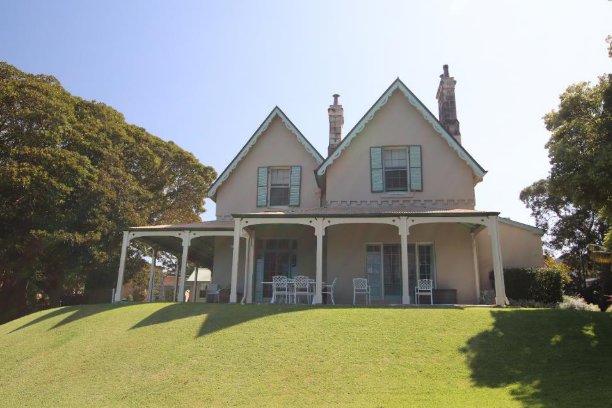
A substantial change to the role of Kirribilli House occurred in 1996 with the election of the Liberal/National Party Coalition under the leadership of John Howard. The new Prime Minister, who held the seat of Bennelong and whose family home was also in Sydney, soon made it clear that he would “…not spend quite as much time in Canberra” as some of his predecessors and that his family would not be relocating to The Lodge (the official Canberra residence of the Prime Minister). When it was found impossible to upgrade security at the family home in Wollstonecraft, Kirribilli House became the Howard family’s main home, the first time it had served this function since 1953.
During the Howard family’s residence, a proposal to relocate the 1880s staircase within the main hall, one of the recommendations of the 1985 Clive Lucas report, finally came to fruition. Not only was this part of the philosophy adopted for the house, but also with only a single occupant, there was no need for the separation between the ground and first floors that Mansfield had been at pains to provide for the use proposed in the 1950s.[96]
Despite its use as a family home, some of the once-favoured facilities of Kirribilli House were abandoned. In 1986, Grace Karskens had identified the Kirribilli House stone harbourside swimming pool (a part of its jetty and boat sheds complex) as “…probably the oldest bathing pool on Sydney Harbour”.[97] However, a report for the Official Establishments Trust in 1999-2000 recommended that the pool and adjacent boat dock be preserved only as ruins as any “residual heritage value” had been “…irrevocably diminished by substantial work undertaken in 1968” and that there was no prospect of a boat dock being used in the future.[98]
After eleven years as a family home, the role of Kirribilli House changed swiftly following the Labor election victory in 2007. Prime Minister Kevin Rudd confirmed that living in The Lodge was Labor party policy and that he would not be departing from that arrangement. In May 2008, the Prime Minister announced that Kirribilli House would be made available to up to ten registered charities a year, for fundraising purposes, a new departure for a government residence that had once been intended to place a “special occasion” role, for distinguished guests of the government.[99] This policy had begun to be implemented when Kevin Rudd was replaced as Prime Minister by his deputy, Julia Gillard in June 2010. Prime Minister Julia Gillard continued this arrangement until she was replaced by Kevin Rudd in June 2013.
Following the election of Tony Abbott as Prime Minister in September 2013, Kirribilli House became the primary residence of Abbott’s family while work on The Lodge was being undertaken. Between September 2013 and September 2015, Prime Minister Abbott resided between Kirribilli House and the Australian Federal Police Academy College while works to The Lodge continued.
In September 2015, Tony Abbott was deposed as party leader and Malcolm Turnbull became the new Prime Minister. With work on The Lodge complete, Prime Minister Turnbull confirmed that the Lodge will continue as the primary official residence of the Prime Minister, and that Kirribilli House will be used for official purposes of the office of the Prime Minister.
In 2022, the Australiana Fund compiled an illustrated care manual (The Australian Fund, 2022) for the collection of artwork, furniture, and memorabilia on loan for display at Kirribilli House.
This section (verbatim) was prepared by Geoffrey Britton in 2015 as part of the GML 2016 HMP to confirm and update Britton’s assessment that was completed as part of the Design 5 2010 HMP.
After many decades of development there remain persistent components of a much earlier, pre- European landscape within the Kirribilli House site. These can be summarised as underlying landform, remnant vegetation and the site’s ancient relationship with the drowned river valley that now forms Sydney Harbour.
Despite various earthworks—including nineteenth-century levelling for house benches and terracing of steeper areas—the basic site morphology remains largely consistent with that formed thousands of years ago. Obvious components include the dramatic sandstone cliffs at the eastern edge (mostly visible from marine craft within the harbour) and the massive line of outcropping running through the central part of the site to the northeast, east and southeast of the house.
Some of this latter feature has been covered by grass or obscured by the growth of garden plants. In other places the rock outcropping has been built over with steps (the access path near the southern boundary), or hidden by the recently installed large water tank. Prior to the water tank’s installation, the area behind it was a sandstone outcrop that provided an intimate, secluded space within the grounds contrasting with the open, expansive lawns nearby. It likely also afforded an excellent viewing prospect out to the harbour.
Persistent locally indigenous vegetation includes Port Jackson fig (Ficus rubiginosa)—at least one old specimen remained near the south eastern corner of the site throughout the nineteenth century and half of the twentieth century (it was removed by c1968). A specimen of this species survives near the main entry gates at Kirribilli Avenue and other seedlings remain along the eastern cliff line. Smooth-barked apple (Angophora costata) also remains on site and is evident in the archival record. Additional indigenous representatives on site include a few struggling trees under the large Hill’s fig tree, and another regenerating tree near the eastern cliff.
Other local species present include several coastal banksias (Banksia integrifolia), blueberry ash (Elaeocarpus reticulatus), sweet pittosporum (Pittosporum undulatum) and spikerush (Lomandra longifolia).
The vegetation would originally have consisted of shrubby woodland dominated by smooth-barked apple (Angophora costata), with fewer Sydney peppermint (Eucalyptus piperita) and red bloodwood (E. gummifera), and subdominant small trees Christmas bush (Ceratopetalum gummiferum), black sheoak (Allocasuarina littoralis) and various sclerophyll shrubs on the ridges, slopes and headlands. This would have passed into a depauperate rainforest in the sheltered gullies running down to the harbour, these dominated by Moreton Bay fig (Ficus macrophylla) and lillipilli (Acmena smithii) with subdominant cheesewood (Glochidion ferdinandi), black pencil cedar (Polyscias elegans), sweet pittosporum (Pittosporum undulatum) and bleeding heart (Omalanthus nutans). Swamp sheoak (Casuarina glauca), Port Jackson fig (Ficus rubiginosa) and coastal banksia (Banksia integrifolia) are still to be found dominating the rocky shoreline vegetation with subordinate tough herbs such as matrush (Lomandra longifolia) and blue lily (Dianella caerulea) beneath.
Eight species occur on the site that can be considered native there. These are Angophora costata, Banksia integrifolia, Dianella caerulea vel aff., Elaeocarpus reticulatus, Ficus macrophylla, Ficus rubiginosa, Lomandra longifolia and Pittosporum undulatum.
With the early site development and building of Kirribilli House came levelling and smoothing of landscape contours. Together with the early build and later house modifications, these site interventions are still partly discernible as benching and banking. Apart from the marine precinct, various archaeological resources—especially within the northeast lawn and the elevated area west of the house—may also reveal some of this early development.
Evidence of the nineteenth-century layout remains apparent in areas such as:
Also, of nineteenth-century origins are:
From archival material it appears the garden walk followed approximately the present path—winding down from the northeast verandah, past the northern fence, then generally along the contour across the grounds close to the eastern cliff line before, possibly, climbing again along the southern boundary.
The 1890s images from the Mitchell Library (refer to Figures B.5 and B.6 in Appendix B) also show various flights of steps within the reserve allowing access to the water. It is feasible that some, if not many, of the existing steps within the reserve were built as part of the Kirribilli House development in the nineteenth century and simply reused as convenient water access when the reserve boundaries were established (probably) in the early twentieth century.
Some of the extant plantings, such as the two bull bays (Magnolia grandiflora) behind the house and the large camphor laurel (Cinnamomum camphora) at Kirribilli Avenue, are very likely to have been introduced in the nineteenth century. Others are either also possibly from the nineteenth century or early twentieth century such as the large clumping plants Strelitzia nicolai (near the southern boundary and northern boundary) and Phoenix reclinata (near the path to the marine precinct), and the solitary Firewheel Tree (Stenocarpus sinuatus) at the northern boundary fence.
Other likely nineteenth-century plantings that have since been removed include the lemon-scented gum (Corymbia citriodora) at Kirribilli Avenue, the flame tree (Brachychiton acerifolium) formerly within the front drive loop, another camphor laurel (Cinnamomum camphora) formerly near the northern boundary, and the kauri pine (Agathis robusta) formerly near the northeast corner of the house.
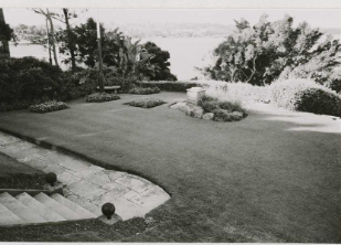
Beyond individual plant species, a hallmark of the historical grounds evident in the archival photography is the rich character of the gardens created through use of a variety of foliage plants and strategic placement to provide shade, shelter and screening. There are only glimpses of such compositional richness and structural organisation within the present grounds, and these mostly occur where older trees remain as a foundation for later plantings.
The prospect of spectacular harbour scenery, from both house and grounds, has been a feature of the place since the 1850s—though the site undoubtedly also offering scenic prospects for countless others a long time before that. Historically, as is the case presently present, the grounds offered vistas (eg from the front entry), filtered views and glimpses of the harbour through foliage, and broad panoramas.
There are also other important legacies from the nineteenth century still manifest at Kirribilli House. These include the enduring relationship the place has with its immediate neighbour, Admiralty House, from which estate the Kirribilli House grounds were originally subdivided. It is both rare and remarkable that these two major marine estates remain essentially intact. The two are appreciated together from around the harbour and are regarded as integral parts of the iconic harbourside scenery.
There is also considerable collective value contributed by Kirribilli House, Admiralty House and many of their surviving nineteenth-century neighbours such as Sunnyside (1862), Burnleigh (c1875), Newton (1870) and the Kirribilli Neighbourhood Centre building (1873). There is also value in the contribution Kirribilli House makes in combination with its streetscape neighbours, such as the residence across the road.
After changing ownership several times from 1913, Kirribilli House was acquired by the Commonwealth of Australia in 1920. Several changes within the grounds are discernible from the earlier part of this period.
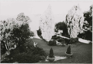
An obvious one is that the present garage (built by 1930) now stands as a replacement for the former outbuildings to the west of the house. Between 1920 and 1930 the property was tenanted to various prominent people and it is possible that the present Monterey cypress (Cupressus macrocarpa) and the nearby jelly palm (Butia capitata) were introduced, along with the Himalayan cedar (Cedrus deodara). It is possible other trees may date to this general period also—such as the Hill’s fig tree—though it is unclear if this was planted or bird-propagated. Alternatively, this tree was introduced as part of the 1957 grounds makeover.
The 1957 letter from L D Pryor records the existence of a lillipilli (possibly still remains), kauri pine (removed), the flame tree (removed), lemon-scented gum (removed) and Ginkgo biloba (removed). Many of these trees would have been planted prior to 1920, though it is possible the lillipilli was one that was introduced after 1920.
Correspondence from 1922 indicates that Charles Weston, as head of the Yarralumla Nursery in Canberra, was directly involved in the despatch (and possibly also the plant selection) of species to Kirribilli at that time. Weston would have known the site, its soils and microclimate intimately as he was formerly the head gardener at Admiralty House for 10 years, living on site in the gardener’s cottage before moving across the harbour to work at Government House for a further four years.
Much of the current layout in the northern and western sides of the grounds dates to the major transformations of the 1957 construction phase. During this period, the staff wing and other building alterations were undertaken. The driveway and drive loop were also added. Even the eastern side was affected banking was continued across the site with the addition of more flights of steps, and the earlier more dramatic bank was terraced to help use up spoil from the excavation on the western side.
A further flight of steps (and extended garden bedding) appears to have been added in the 1970s (possibly during the Fraser incumbency) to the southern end of the central rock formation. The repeated practice of adding flights of steps at various places with no connecting pathway created more problems than it solved. Each new set of steps then required a later pathway only to be confronted with the necessity of more steps to negotiate remaining changes of level. An unfortunate consequence of this cycle was the gradual erosion of the earlier sense of ‘wildness’ and drama that befitted the picturesque character of the site.
The 1957 report on the work at Kirribilli House states that Professor EG Waterhouse assisted with advice on the grounds in 1957. While having a distinguished academic career as a linguist, Waterhouse was also well respected as a horticulturist and camellia expert even to the point of becoming an advisor on landscape projects at Sydney University (main quadrangle, vice- chancellor’s courtyard and St Paul’s College campus), the Teachers’ College and Royal Prince Alfred Hospital. It is assumed that the older camellias within the grounds, including those below the central rock outcrop and the large Camellia reticulata at the southern boundary, would have come at the suggestion of Waterhouse.
The large Hill’s fig tree is more problematic. It could either have been introduced sometime between the interwar period to 1950s or been propagated by birds during this time span. The very broad, spreading canopy of the fig tree is affecting the viability of plants under it, including a large group of locally indigenous species such as Angophora costata. Other smooth-barked apples lined the main driveway in the 1960s and 1970s, but had gone by 1986. The smooth-barked apple is a species that is otherwise highly desirable to have on site.
The mature Macadamia and Backhousia seem about the same age and were plausibly planted c1960sthere is no sign of the Macadamia in the 1957 photography of the western area and driveway precinct. It is possible that these plantings were instigated by Bettina Gorton (resident 1968 to 1971) as it is consistent date-wise and circumstantially—especially given her demonstrated advocacy of Australian flora and in providing the impetus for the famous Native Garden at The Lodge.
While possibly an earlier introduction, the aggressive Ficus pumila that functions as a makeshift hedge along the central rock outcrop may have been introduced as part of the 1980s recommendations. However, it is now threatening to engulf everything around it including rock outcropping and any other nearby plants—even trees. Although seemingly demure in its small-leafed juvenile stage it soon develops a larger and more aggressive adult type of foliage, and Sydney’s climate is very conducive to its fast-spreading and invasive habit. It probably should not be retained on site.
Very recent additions to the grounds include kentia palms (Howea forsteriana) (an appropriate choice in cultivating a Victorian landscape character) at the northern side of the house and, during the Rudd incumbency, a jacaranda within the drive loop as a replacement for the lost flame tree.
Of particular concern is the obvious demise of several older trees, such as the large camphor laurel, old flame tree and large lemon-scented gum, along with the near total defoliation of the remaining large camphor laurel. A solid and continuous line of trees along the northern boundary appears to have been a key feature of the place since at least the early twentieth century and likely earlier.
The 1950s remodelling of the northern spaces was a radical departure from the nineteenth and early twentieth century form, but was ameliorated by the retention of the mature trees along the northern boundary and along the driveway. The loss of many of these trees has had a substantial impact. Currently the important arrival spaces (whole northern side) are a partly successful development from the bland and austere landscape apparent in the 1980s. There is also currently evident a preponderance for neatness rather than a rich mixture of plant species consistent with a Victorian harbourside mansion.
There appears to be no clear direction on either the treatment of major precincts within the grounds such as the important approach sequence or the eastern cliff line where earlier exotics and locally indigenous vegetation are vying with environmental weeds—or the use of lighting elements and furniture (eg the inappropriate kidney-shaped stone seat). Walling varies from 1960s ‘fieldstone’ walls to very poor-quality mortared stone walling that needs replacing.
The former marine entry and saltwater pool precinct remains ruinous after the 1960s removal or unnecessary displacement of much stonework.
The purpose of this review of documentary material is to determine, as much as possible, what the place was like in its earlier phases and then, by comparing these characteristics with current evidence, establish a basic site development chronology and level of integrity that then helps to inform the assessment of significance. To do this each of the key archival records are analysed below and obvious site developments are noted.
A plan of 1856 shows the land acquired by Mr Feez from Mr Travers as well as land required for national defence purposes at the southerly point (Kirribilli Point[100]) (Figure 1‑9).
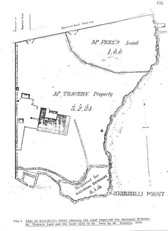
Figure 1‑9: 1856 plan showing area required for national defence purposes
The plan clearly shows the arcing boundary with Wotonga (sic) as it was separated by subdivision. It also shows the splayed entry recess from the road reservation at the north-western corner of the site along with boat mooring structures into the harbour at the eastern edge. The road reservation also shows some indecision with a bold line denoting the northern boundary of the Kirribilli site but a dotted line projecting further to the north.
The 1883 plan for the Parish of Willoughby indicates the presence of the house ‘Kirribilli’ shown dashed graphically, the splayed entry recess of Campbell Street and the confusing eastern end of the northern road reserve where the northern property boundary seems to twist out to the north-east over the road reserve.
Of particular note is the extent of substantial development of the marine facilities where two enclosures are shown – one labelled ‘Boat Shed’ (to the north and parallel to the harbour) and the other “Fish Pond”[101] (to the south and perpendicular to the harbour). Above these is a line indicating the upper extent of the cliffs near the eastern boundary of the site and the faint indication of the access linking the maritime facilities with the top of the cliffs which accords with the present line of access between the two.
This document records the detailed field notes of the site by Surveyor T G Wilson and, although not drawn to scale, provides descriptions of structures and materials. One of the areas of interest is at the harbour edge where the marine facilities are outlined and described as containing at least three weatherboard boathouses and three flights of, presumably, stone steps. Some form of safety balustrading is also shown graphically at each of the water edges.
Another area of interest is at the north-eastern corner of the house where splayed steps are shown off the northern end of the verandah and, further to the east, a rectangular outline is described as being weatherboard with (as far as can be deciphered) the word, “Tank” in it.
Beyond this, the northern boundary is noted as being fenced, the splayed entry recess is clearly outlined, some bedding is shown in front of, and parallel to, the northern house bay outline, substantial weatherboard buildings are shown to the west of the house with a cobblestone area between them and a verandahed link to the house. A note to the left of the field sketch indicates that the spire of St Mark’s (presumably Darling Point) was used to make directional references.
This plan is probably the finished version of the previous in sketch form and is virtually identical to another survey of 5 April 1892 in the Stanton Library and the 1985 CMP report. The plan confirms the status of buildings and other structures across the site by this time including the full complement of built elements at the marine entry, the western outbuildings to the house and the small weatherboard structure to the northeast of the house labelled as “Tank”.
It also confirms the general alignment of the eastern cliff line, adjoining outbuildings with Admiralty House and provides yet another permutation to the northern boundary line in relation to the road reserve (still Campbell Street).
While offering no new information about site development this plan does continue to confirm that the site allotment has remained exactly the same since its subdivision in the 1850s.
Evidence of the direct involvement of Charles Weston and the Yarralumla Nursery in the review of Kirrabilli House grounds after its government acquisition is provided in a letter from the Afforestation Branch in Canberra of 12 May 1922. The following plants (the old nomenclature is retained) were despatched by Weston from Queanbeyan Railway Station to Mr M Minnett, Head Gardener, Admiralty House via Milsons Point Station:
The large number of Cupressus macrocarpa suggests their use for a hedge but no such feature currently remains part from a solitary cypress to the east. Of the other species listed here, only one Deodar Cedar remains and the preponderance of conifers is quite consistent with Victorian taste.
Although somewhat sparse in detail, this extract off the 1930 plan for the Parish of Willoughby shows the present motor garage. This indicates that it was probably built in the 1920s following the purchase of Kirribilli House by the Commonwealth of Australia. The plan also shows the house footprint through no outbuildings.[102]
An indicative rendering of the main gate entry is shown as a curved bay indent. The most elementary indication of buildings is shown adjoining the site boundary with Admiralty House though no structure is shown in the lawn to the northeast of Kirribilli House. This may mean that the former weatherboard structure with the ‘Tank’ has also been removed by 1930.
A watercolour rendering by G V F Mann in 1932 shows Kirribilli House in a dramatic setting from the southeast. The house is framed by vegetation on the extreme left (existing Bull Bay [Magnolia grandiflora]?) and to the right (a former Moreton Bay Fig Tree [Ficus macrophylla]) with a dense, continuous line of vegetation behind the house to the northeast.
Of note also is the sheer, even grassed bank falling to the harbour from the verandahs indicating the earlier (typical 19th century) form of the banking before the present terraced arrangement. The 1985 report also describes the colours used in the work anticipating black and white copies of the document.
This very useful record of the marine entry precinct details levels, layout and materials used throughout this important area. Of note are the annotations for the stepped access to the area from the main grounds. The extended, straight section – in exactly the same alignment as that existing – was built from two long flights of timber steps off concrete steps at the top with a long flat section using natural rock outcropping.
Although the earlier surveys of this area do not reveal the connection between the shoreline and the upper grounds, it is likely that this line of access has remained constant, only the materials being changed.
Other survey notes describe where bedrock has been cut to form steps or the boat harbours; masonry blocks used to form the arcing breakwater; and concrete steps added to provide better access. However, no buildings are indicated.
This important survey plan forms one of the most crucial records of the grounds as it describes the character, layout, levels and some of the features of the site just before the most transformative phase since the initial site development about one hundred years earlier. A reading of this survey with the 1957 grounds plan provides much information about the extent and scale of 1950s interventions.
The 1956 survey clearly shows the uniform steep bank (Figure 1‑10)[103] off the house verandahs before the present terraces were introduced, the earlier main entry gate ensemble at Kirribilli Avenue (including placement of piers – most matching the existing arrangement), the earlier flights of steps off the northeast verandah and main entry porch and the arrangement of the entry path (shown in concrete by this date).
A flagged path is described running along the western end of the house, then a concrete path at the southern return but with another stone flagged section (and associated ornamental pond) linking the house with the boundary to Admiralty House. A flight of steps is shown adjacent to the western doorway leading up a bank.
The concrete path at the front house entry continues in a series of (presumably ramping) bends to steps down the steep slopes to the northeast of the house finally leading to an asphalt path that traverses the upper edge of the eastern cliff line. Unlike photographs of the same period, this plan also confirms the existence of a designated garden walk within the grounds as would be expected of most places of this scale.
In a line projected off the northern façade of the house there is a note of ‘steps’ beyond the eastern cliff line indicating the access to the marine precinct and further to the south is a rectangle possibly indicating the lancet-shaped lattice portal shown in archival photographs. Apart from the house and the garage, no other structures are noted.[104]
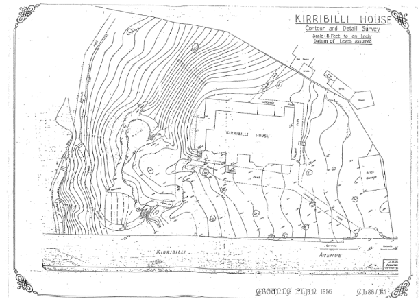
Figure 1‑10: 1956 Survey Plan (Department of Housing and Construction Landscape Architects ACT Region, 1986)
Also east of the house verandah is the present large rock outcrop formation along the central part of the eastern grounds. The survey records the upper cliff edge as well as the lower rock ledge. The form of the outcropping appears to have dictated the location of steps with one flight shown to the north skirting above the rock while, to the south, a flight (presumably the existing one cut into the rock) is shown wedged between rock outcrops.
Not all of the annotations for existing vegetation are decipherable or provide identification, especially on the northern side of the house. Those that are, however, include a ‘Moreton Bay Fig’ in the southeast of the grounds, a ‘Magnolia’ at the bottom of the bank near the Admiralty House boundary and, what appears to be, a ‘Grey Gum’ to the north of the house. Given the general level of identification evident the latter may have been a locally indigenous Angophora costata. All other plant symbols appear to be labelled, “Tree”. Correlation with later records, however, soon reveals the identity of many of these otherwise anonymous former and existing species.
Two of the 1956 drawings used for the later site contract work document the extent of changes to the Kirribilli House landscape since the 1956 survey. Drawing 56 1411/1 provides ground and first floor plans and an elevation and section where substantial cut and fill is indicated, and instructions given such as ‘remove stone steps’ for the former splayed steps to the northeast verandah as well as those to the front porch.
The elevation and section reveal that the former outbuildings (removed by 1930) must have been built across the rising ground to the wet of the house with stabling closest to the western boundary. As it shows the line of the earlier ground levels west of the house it implies that a considerable amount of cut material has been excavated to allow for the 1957 staff wing and that, where levels have been retained or filled (such as above the stone retaining walls), there may remain some archaeological evidence of the former 19th century outbuildings.
At the northeastern side of the house the elevation and ground plan show where levels have been filled to raise the new drive loop to meet the upper slab of the entry threshold. This was done on the basis of attempting to retain the two existing trees in this location – the one in the front of the porch being a Flame Tree and the other possibly a Kauri Pine (both trees have since gone).
The ground plan also shows an earlier version of the path layout to the northeast of the house and confirms the intention to reconfigure the levels around this area consistent with the raised driveway. It is possible – and logical – that excavated material from the staff wing was used to fill areas for the drive loop and the bank terracing to minimise the contract cost of removing soil off the site.
Another drawing (56 1411/4) confirms the arrangement of the gated entry in 1956 and the extent of modification required by the new work. This entailed retaining the two sandstone walls and enclosing piers facing Kirribilli Avenue along with the western pier forming a gate top the west. The earlier pedestrian gate and inward pier were removed with a new curving section of stone wall being built to enclose new wrought iron gates.
The drawing also shows that an existing timber paling fence was retained along part of the northern boundary, though this has since been replaced.
Together with the 1956 site survey, this plan readily reveals the extent of changes arising from the 1957 works contract among which include the broadening of the old earth bank to the east and formation of two intermediate terraces; the filling of the area in front (north) of the house and introduction of a paved (gravel) drive loop and turning circle, the removal of earlier stone steps (and early iron railings); the reconfiguration of the entry gates and the addition of the staff wing along with associated stone retaining walls and steps following substantial excavation.
With substantial interventions to the west, north and southeast of the house the 1957 work effectively changed about half of the grounds. The nature of some of these changes – such as the introduction of the bank terraces – also meant that further changes were left implied, and which were duly fulfilled subsequently. In the case of the terraces later changes included the addition of more steps and paths to take advantage of the easier access provided by the terracing.
Other site modifications involved replacing the earlier southern connection to Admiralty House with a new flagged pathway (and a new paling fence and gates) and curved threshold where the earlier conservatory was demolished, the provision of a new stone paved connection into the grounds of Admiralty House from the new western courtyard. Interestingly the former small pond next to the southern pathway has gone.
Curiously, however, while one of the old bull Bays are shown near the southern boundary and the former Moreton Bay Fig Tree is not shown (as it has presumably been removed), the plan shows the present mature Jelly Palm as an ‘existing palm’ – along with a small pond next to it – though the 956 survey omitted the palm even though it must have been present.
In a letter to the Prime Minister’s Department the architects Fowell, Mansfield and Maclurcan set out their design intentions for the grounds of Kirribilli House, foremost of which were the objectives of ‘economy of maintenance’ and ‘to present the appearance of a garden to a private house than that of an official building’. A preliminary plan originally accompanied the letter, but this has not been found.
The recommendations further listed that the immediate house environment be cultivated with plants ‘suitable to the architecture’ and ‘favoured by the early pioneers’. Two remaining objectives are particularly interesting as they advocate the use of Australian plants generally for the benefit of overseas visitors and the use of locally indigenous species along the harbour edges.
A later suggestion in this letter, referring to the intermediate outcrop known as “The Bastion”, is for the existing ‘ficus and other growth along the cliff edge’ to be ‘severely cut back and to some extent removed’ and, where feasible, replaced using ‘more interesting native plants’. This may refer to the existing problematic Ficus pumila that has covered the entire rock outcrop and many of the plants around it.
The letter also includes many plant species suggestions and locations for these and, despite emphasising the need to reduce maintenance commitments, specifies the use of annuals, herbaceous borders, hedges and fruit trees. Camellias and azaleas were stipulated as feature plants within the northern entry areas and even climbing plants ‘of restrained habit’ were suggested for corner verandah posts.
The demise of the old fig tree at the south-eastern corner was contemplated in 1957 as the letter indicates that it ‘will probably be removed and a plantation of Callitris is suggested at this point’. The existing examples of Monstera deliciosa probably date from the later 1950s as this species is recommended in the letter as well as Acanthus.
Two letters from Professor Lindsay Pryor, then Head of the Parks and Gardens Section of the Department of the Interior, to Ken Herde of the Prime Minister’s Department provide considerable insight into the thinking behind the changes to the grounds at Kirribilli House in 1957. In the first of these letters, Pryor acknowledges the existence, and desirable retention, of a number of the earlier plantings such as a Kauri pine and the Flame Tree near the main entry of the house, a Lillipilli (possibly the existing Syzgium to the lower north-east grounds) and a Lemon-scented Gum (probably the one now cut down at the northern boundary).
Pryor also graciously offers advice on Mr Mansfield’s landscape planning and makes various recommendations to fine-tune the Fowell, Mansfield and Maclurcan proposals. Chief among these considerations is the need to reduce areas of lawn where the amount of shade would preclude its viability. However, the shade regime current when Pryor was writing was quite different to that of today on account of the recent loss of so many of the larger canopy trees.
In supporting Mansfield’s proposal for native plants around “The Bastion” area, Pryor provides a list of suitable species that include some local Sydney plants such as Eriostemon (now Philotheca), Banksia spinulosa, Telopea and Grevillea buxifolia. Pryor goes on to suggest the addition of several NSW rainforest trees such as Red Ash (Alphitonia excelsa), Red Cedar (Toona cedrela) and Flindersia oxleyana (syn. F. xanthoxyla) for the lower grounds.
Other exotic trees recommended by Pryor, such as Dawn Redwood (Metasequoia glyptostroboides) ‘to accompany the fine Ginkgo which already exists’ along with a Chinese Elm (Ulmus chinensis), Swamp Cypress (Taxodium distichum) and Zelkova. Concluding paragraphs indicate that camellias and azaleas are likely to be ‘extremely expensive’, though certain strategic locations may justify such expense and that an umbrageous tree is warranted near the main entry gates – a role presently filled by the large Macademia tetraphylla though apparently not included in the 1957 plantings.
A second letter from Pryor to Herde about a month later provides a list of suitable plants for the Kirribilli House garden, along with potential sources of supply including the Yarralumla Nursery in Canberra (a long list of mostly exotic shrubs and trees including two specifically marked to Mr Mansfield!), the Forestry Commission of NSW (mainly rainforest trees), the Sydney Botanic Gardens (a mixture of native and exotic shrubs and groundcovers), Professor E G Waterhouse (camellias and azaleas) and D W Clarke, Hazlewood Bros. and Swane’s (another list of mixed ‘old garden’ species). Lastly, Pryor suggests that certain divisible species such as Agapanthus and Arum Lilies could be obtained from the Royal Botanic Gardens and Admiralty House. Figure 1‑11 shows the grounds plan dated 1957.
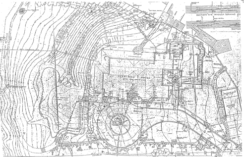
Figure 1‑11: 1957 Grounds Plan (Department of Housing and Construction Landscape Architects ACT Region, 1986)
A July 1957 letter from the architects recommends a treatment for a suitable connection between Admiralty House and Kirribilli House involving stone flagged paths and steps, a timber gate and timber lattice fence. The proposal was approved and the works subsequently carried out.
In November 1957, the Prime Minister’s Department wrote a report as a record of works carried out at Kirribilli House between February and October of that year. Under “Garden and Grounds” the report states that the “…architects’ landscape plan was carried into effect by the Head Gardener of Admiralty House, Mr G W Gillham, and his staff” and that “…Professor E G Waterhouse generously gave of his time on (sic) advising on the planting of Camellias and Azaleas and the pruning of certain trees”.
The report also confirms the tripartite planning approach as “…near the house having the atmosphere of an early Australian garden with old fashioned plants; exotics that flourish here and are an attraction to visitors from other climates; and on the lower slopes towards the Harbour, ‘local flora”. It also states “…three electric light standards, having been adapted from 19th century gas lamp posts, [were] generously donated by the Australian Gas Light Company".
Under “Garden Suppliers”, the report indicates that “…The Department of the Interior, Canberra [i.e. the Parks & Garden Section under L D Pryor], the Botanical Gardens, Sydney and D W Clarke P/L” supplied either trees, shrubs or other plants, while the Camellia Grove Nursery (established by E G Waterhouse in 1939) supplied camellias and azaleas. Despite L D Pryor’s earlier suggestion, the Forestry Commission of NSW is not listed as a supplier. H Grounds & Sons supplied a concrete seat and pots.
This drawing confirms the extent of work carried out in 1957 including the building of the staff wing, the addition of the drive and drive loop, a guardhouse, a redesign of most of the western side of the house, the rearrangement of the entry gate ensemble and the regrading of the main grassed bank.
A letter of 1961 by the accountant J Cassidy provides an outline of decisions made regarding site planning and design – without any reference to architectural or professional design advice – that has left an unfortunate legacy within the Kirribilli House grounds. Cassidy records his approval to construct stone walls as a safety barrier in the southeastern part of the grounds and some of this – while we-meaning – has been built around the base of the Monterey cypress. Some poorly built stone walls in other parts of the grounds may have been introduced at this time.
Of equal concern was the instruction to use sandstone blocks from the 1850s boat harbour walling to be reused to form a barrier to the northern boundary as well as one to raise the level of the driveway further to reduce the slope. The latter development would have exacerbated existing rising damp issues. Generally, the nature of this work contrasted with the more carefully planned, designed and executed work of the 1950s. The 1960s work was undertaken ‘in-house’ to save on costs.
Within the twenty or so years between the 1950s documentation and this late 1970s survey several further grounds interventions are evident. These include the large circular ‘Fish Pond’ within he lower lawns (introduced in the 1960s) and associated plantings, a pergola nearby at the southern boundary, a flight of steps and an extension of the bedding at the bottom of the grass banks, additional steps along the winding pathway to the northeast of the house, a flagpole with stays and anchor points in the northeast lawn, two new ‘bush houses’ to the west of the staff wing, cannon balls at the base of the northeast steps, a small rockery near the steps to the harbour and various tree plantings.
Of the latter, notable additions may include another Maidenhair Tree (Ginkgo biloba) immediately south of the southern verandah and a ‘poplar’ (actually a former Claret Ash) within the 1950s western courtyard – both of which have been removed. Other plantings within this period are highly likely though from a comparison of these plans alone it is impossible to determine which ones.
In terms of describing plant species where trees are noted, the 1979 survey is notoriously inaccurate with, for example, Bull Bay consistently given as Moreton Bay Fig, Angophora costata given as Spotted Gum and the former Flame Tree as Kurrajong (right genus, wrong species).
Just prior to further site works being undertaken, the 1986 grounds plan also confirms many of the features noted from the 1979 survey and provides a basis of comparison with the most recent site survey.
The earliest available photography of the Kirribilli House grounds is from the William Hetzer collection of the late 1850s and the early 1860s. Of three stereopair images of the Kirribilli peninsula, two are clearly of the Kirribilli House site where one shows the boat sheds and sandstone cliffs along the eastern shoreline and the second shows the house and eastern side of the grounds.
Both photographs show that the eastern edges of this part of the Kirribilli peninsula were still well vegetated with locally indigenous species such as Angophora and Allocasuarina or Casuarina, the latter now conspicuous by its general absence and the former struggling to remain. The photograph along the shoreline (Figure 1‑12) shows a rugged sandstone landscape as the marine interface and a tall timber paling fence running down to the water though only part way up the slope. Beyond this are timber-boarded structures over sandstone block seawalls. Another taller fence is shown further up the slope and further back from the first fence. An unidentified object or structure is visible part way up the slope.
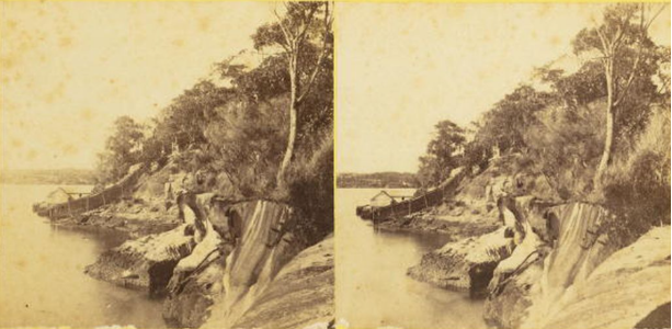
Figure 1‑12: Photographic print, mounted stereoview, Kirribilli looking south, published by William Hetzer, Sydney
The second photograph (Figure 1‑13) – taken near the extreme south-eastern corner of the site – contains considerable detail of the eastern side of the house where ornamental bargeboards, shuttered gable windows, shingled roofs and ogee verandah gutters are clearly visible. A family group (man, woman and child) is shown sitting on the grass to the southeast of the house and part of a flat bar estate fence or gate is also partly visible in the foreground. These views are partly obscured by the foreground vegetation that features a large limb from an Angophora costata to the right and a sheoak (Allocasuraina littoralis or Casuarina glauca) to the left. Another sheoak is visible to the extreme right.
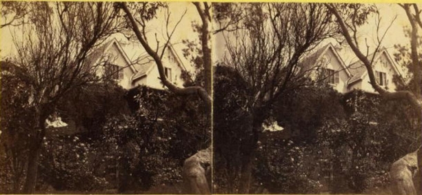
Figure 1‑13: Photographic print, mounted stereoview, Kirribilli looking south, published by William Hetzer, Sydney, 1860-1863 (Source: Powerhouse Museum Collection, 1019_15
By the early 1860s these photographs are not expected to show much of the plantings within the grounds of Kirribilli House as the house had only just been built but the second image indicates that the steep grassed slope had been finished and the first image shows that the marine precinct had been substantially built. Both clearly demonstrate that a diverse locally indigenous vegetation was still relatively well-distributed across this part of the Kirribilli shoreline by the mid-19th century.
Another 19th century photograph, described as 1860s, appears to show the whole of the eastern side of the site. Given the much more advanced state of the grounds and plantings and that the eastern cliff line is shown as a continuous grassed bank the photograph was more likely from about the 1880s.
The image holds a considerable amount of information about the site. Apart from excellent detail for the boat harbour, saltwater pool, marine structures and path access, the image reveals that much of the local indigenous vegetation has been cut back or removed and replaced with either grass or beds of ornamental plantings and neatly sculpted shrubs and hedges. On the left side, a maturing pine tree (dark foliage) is visible with possible low hedging (and a white gate?) near it. A dense and continuous band of vegetation is shown all along the boundary with Admiralty House.
On the right side of the image a fence is visible at the water’s edge, although the actual site boundary is later shown to be further to the south near the northern edge of the first boat shed. This indicates that the Kirribilli House gardens once extended into the present Lady Gowrie Lookout reserve and that there was no fence along a large part of the northern grounds allowing ready access along the terraces from the grounds to land further to the north.
The same general area also shows a maturing palm tree amid rounded shrubs and curvilinear snaking hedging, steps, seating and some of the massive sandstone outcrop to the northeast of the house. Above this outcrop, and just in front of the main entry porch, is a small structure that also appears in later photographs.
The first of the images from the 20th century (Figure 1‑14) shows the principal view to the house from the entry pathway with various figures standing at the northwest corner of the house. It also features the strong forms of the house such as the dramatic gables, chimneys, castellated bay with a fine wirework arch (with climbing rose?) in front and the projecting porch with its shingles and lantern.
There is a tall, lapped timber paling fence screening off the service area of the grounds from the main arrival precinct and recent plantings of typical textured Victorian favourites such as Cordyline species and various palms in the foreground. The front entry path appears relatively narrow – at least up to the bay projection – and is defined by a low, hedged estate fence that curves back towards the service fence on one side and, on the northern side, another part hedge beyond which the shadow along the ground seems to indicate a low picket fence.
Looking out past the entry porch, the view is obscured by the projecting foliage of a fig tree beyond the house and the overexposed edge of the photograph where, possibly, the harbour might have been otherwise visible.
To the northwest corner of the house, a skillion addition is crudely screened by a lattice partition and this, along with the western side of the addition and part of the stone walls beyond, are covered by a dense climber (possibly Cat’s Claw Creeper [Macfadyena unguis-cati]).
Foliage from a large, unidentified tree frames the upper right-hand side of the image and, from the amount of shade projected to the south, there may be several large trees to the north of the entry path providing a cool approach to the house in summer.
The second image from the W H Davis Photographic Collection appears to be taken in the lower grounds at the acute junction of the main northern walk and a lower pathway leading, formerly, across into the northern reserve. It shows fine metal estate fencing (flat bar posts and five rails of round bars) as safety barriers to each of the sheer drops and a broken bitumen path with half-round glazed terracotta drains either side.
Sandstone steps (the upper step with a drainage channel cut at the end) lead to the lower path of concrete with a large white bollard and tap. Planted borders define the upper path and a large feature plant (Doryanthes excelsa or Furcraea foetida?) anchors the corner junction of the two paths. Both Ficus rubiginosa and Angophora costata appear to be present framing views to Neutral Bay. A stump of another tree remains at the side of the upper path.
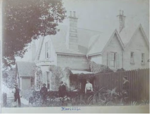
Figure 1‑14: “Kirribilli”, Album of Photographs inscribed “To Mrs. Royle from W H Davis” February 1900-June 1902. (Source: State Library of NSW, ML PXA 4467)
A series of images (about twelve showing the grounds) also survives from the early 20th century though taken slightly later than the previous image. Those used for this analysis are considered in the following order, progressing from the entry gate to the eastern cliff line:
The first photograph (Figure 1‑15) reveals a tantalising glimpse down the miniature hedge-lined main entry path towards the house framed by the taller trees of a mature or maturing garden. The extreme left edge of the image shows the rustic sandstone coursing of a gate pier with its finely worked edge detail (this largely remains though now with tuck-pointed jointing) and dressed capital while the right side shows an Arts and Crafts-style timber gate with ‘Kirribilli’ name plate. The inside gate threshold is shown with fine ceramic tiling and a metal balustrade over a stone base course edges the first part of the pathway. The view focuses on the projecting bay of the house with a classical figure and lantern highlighting a path junction. To the right the two western house gables are visible as is the service screen fence through the gate’s wirework.
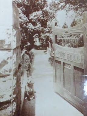
Figure 1‑15: Kirribilli House gate, c. 1913 (Source: Mitchell Library – PXA548 – Kirribilli album)
The next image (Figure 1‑16) shows the sequential view further along the main entry path with the northern front of the house revealed but with the focal point proceeding further past the house to the glimpse of the harbour beyond (though the image copy available is too overexposed at the distance to distinguish water). The foreground indicates that a cross path linked the main entry path[105] with the service area and western house entry (to the right) and a possible garden walk (to the left). Also in the foreground is a more detailed view of the lantern-holding classical figure (painted metal?) atop its plinth and base with the whole sculpture likely a catalogue model. Consistent with the 1900 image (ML PXA 4467) the metal wirework arch is visible in front of the bay as is the metal balustrading to the front porch and the classical urn with miniature conifer beyond.
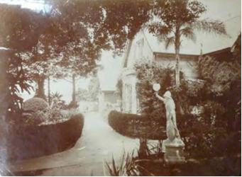
Figure 1‑16: Path leading to porch (now driveway turning circle), Kirribilli House (Source: Mitchell Library – PXA548 – Kirribilli album)
This image also reveals important information about the status of the vegetation within the northern and central grounds. The paths are mostly lined with a low hedge (supported by a low metal estate fence) of small-leaf privet though the large bed screening the service fence appears to have flax (Phormium sp.) and garden tile edging. The northwest house corner has a Cocos Palm of a few years old (though not apparent in the 1900 image) and various plants, including the Cat’s Claw Creeper, mostly screen the skillion addition.
The area to the north of the main path reveals a rich mixture of typically textured Victorian plantings including Monstera (to the extreme left) and Traveller’s Palm (Ravenala madegariensis) as well as carefully pruned shrubs into ‘mounded’ forms. Also evident is a Kentia Palm (Howea forsteriana) near the bay, a fig tree beyond the house and three large trees to the north and northeast of the porch. Of these, two appear to be pines of some kind and the third may be the broader trunk of the Flame Tree that had been in the present drive loop.
A photograph of the western outbuildings (Figure 1‑17) shows typically little vegetative detail apart from the rampant Cat’s Claw Creeper over some of the structures but does reveal two large trees to immediate south of the south-eastern house gable. These accord with the positions and foliage character of the present old Bull Bay and Moreton Bay Fig Tree.
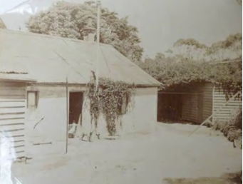
Figure 1‑17: Western buildings, c. 1913 (Source: Mitchell Library – PXA548 – Kirribilli album)
Also, part of the sequential views from the front gate, pass the house and out to harbour, the next image (taken on the curving concrete north eastern path) (Figure 1‑18) shows part of the north-eastern lawn with a classical (catalogue-type) urn and miniature conifer, pruned shrub (Camellia?), Port Jackson Fig Tree (Ficus rubiginosa) near the large rock outcrop and that appeared in a previous view, and low, finial-ornamented weatherboard structure (fern house/tank enclosure?) with timber boarding at ground level beyond. This latter feature is shown abutting a rock outcrop. Also beyond these structures are two bare Frangipanis (Plumeria sp.) and, to the extreme right, the foliage of a tall pine, the cut trunk of another tree (presumably another fig tree) near the large rock outcrop and extensive views across the harbour and eastern suburbs.
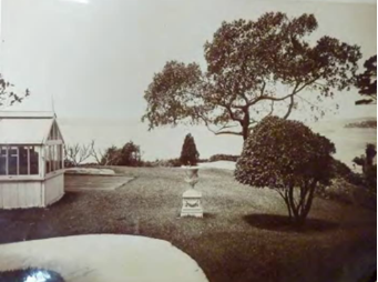
Figure 1‑18: Kirribilli House grounds looking east, c. 1913 (Source: Mitchell Library – PXA548 – Kirribilli album)
The next image (Figure 1‑19) shows a reverse view back to the house with the finial-clad weatherboard structure and a large pine (Kauri pine?) or about twenty years’ growth to the extreme right. The eastern verandah has a selection of furniture across its length, including a Gothic-styled bench seat under the bay window projection (now removed) and a climber up one of the columns. Another climber or tall shrub is shown against the north-eastern wall where the present 1920s addition is located. Low estate fencing supports shrubs edging the curved concrete path and, beyond the house to the south, the foliage of a large tree is evident matching that of the present old bull Bay in this location.
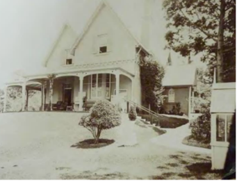
Figure 1‑19: Eastern elevation of Kirribilli House, c. 1913 (Source: PXA-548, Kirribilli Album)
The last two images reveal more detail about the south-eastern part of the grounds from the end of the large rock outcrop around to the boundary with Admiralty House. The first view shows the southern end of the large rock formation with a fig tree below the outcropping and the stump and cut trunk of another embedded near the present cut steps. Shrubs have been planned around the outcrop with ferns covering the southern end. The lawn continues in an uninterrupted sweep from the foreground down the steep slope to the flat area beyond. At this point, a large ornamental area has been fenced off with several bedding areas, of varying shapes, providing an obligatory Victorian embellishment to the stunning harbour scenery beyond.
The enclosed ornamental area is entered through a lancet-shaped timber portal with a low picketed gate. Just outside the enclosure are two large mature trees – one a tall pine (Pinus sp.) with most of its lower branches removed presumably to retain views (and a seat under) and the other appears to be a fine old locally indigenous Port Jackson Fig Tree (not a Moreton Bay Fig Tree as later identified on later surveys). Both trees have since been removed. Beyond is an estate fence at the edge of the eastern cliff line and, at the extreme right, a timber handrail is shown providing some access to a lower level near where an olive tree is presently located.
The final photograph considered in this series (Figure 1‑20) provides further detail about the latticed portal structure into the fenced ornamental area as well as the enclosing fence which appears to be a simple painted top rail fitted into low posts with a small finial. The two bedding areas evident appear to have roses and a low conifer cultivar as central features respectively. The large fig tree frames the image to the right and the harbour views beyond shows Fort Denison, Garden Island and Mrs Macquarie’s Point.
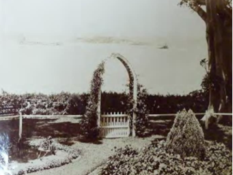
Figure 1‑20: Timber gate, c 1913 (Source: Mitchell Library – PXA-548, Kirribilli Album)
Together with the earlier images above, these c. 1920s photographs provide the best indication of the 19th century status of the grounds prior to the major transformations of the mid-20th century. On the basis of substantial changes within the grounds, the group can be divided into those shortly before the Daily Telegraph image of 14 January 1920[106] and those after. Those before this date were most likely taken either shortly before or after Arthur Wigram Allen’s purchase in December 1919.[107]
The first photograph considered in this group is from the Richardson & Wrench auction notice of 17 January 1920 when the Commonwealth of Australia purchased the property. The image used for the notice is actually from the later 1910s as there is no sale notice visible and the remains of the ornamental gardens within the lower lawns are still evident though unkempt and without the enclosing fence or lattice portal. Similar to the last photographs of the 1900-c.1913 photograph series (ML PXA 548) this image shows the two fig trees either side of the frame with the tall pine in the middle. The cut stump near the rock outcrop is visible and an emerging tree beyond the cliff line is evident (next to the pine).
Two subsequent photographs from the Richardson & Wrench sales brochure shows the site from the Harbour where the sale sign is prominent at the cliff line. Both images provide excellent views of the eastern edge of the site with the most southerly one revealing the rugged sandstone cliffs, a dense mantle of vegetation clinging to the top edge of the cliffs and a small pavilion at the corner of the Admiralty House site. The same photograph confirms the presence of a large old south-eastern fig tree, the tall pine and several other fig trees further along the line of the central outcrop formation as well as forms consistent with Bull Bays to the south of the house and the Flame Tree to the north.
The second of these useful Richardson & Wrench images shows the very fine collection of structures at the marine entry (including two large boat sheds and an open bathing shelter along with considerable sandstone walling), some dramatic paling fencing along the northern site boundary and the fenced, stepped access (with gate) from the house to the boat sheds. This photograph suggests that at least one of the two pines to the north-east of the house is bare. The north-east corner of the site appears well vegetated, and the inflorescences of cliff-hugging succulents are visible in profile at the extreme left.
The photograph appearing in the Daily Telegraph of 14 January 1920 dramatically changes since the previous images: the removal of the tall pine near the eastern fence and the fig tree growing near the central rock outcrop. The canopy of the fig tree has been removed and only two bare trunks remain. Elsewhere the photograph reveals the retention of the large old fig tree near the south-east boundary, large canopies consistent with the southern Bull Bay and Moreton Bay Fig tree, a large cleared and grassed area between the cliff line and the eastern fence, at least two types of succulents near the cliffs (large-leaved Furcraea foetida? to the north and Yucca sp. to the south) and several outlines of trees to the north and northeast of the house.
The last of the 1920s images considere here is an oblique aerial view (SRNSW NRS 15343/1) from the harbour looking to the southern side of Kirribilli House. It clearly documents the extensive lawns throughout the grounds, the dramatic central bank, several paths providing garden walks, the marine entry structures, rock shelving at the harbour’s edge (exposed at low tide), western outbuildings removed along with the small finial-clad structure on the north-east lawn (though the boarded area across the ground seems to remain) and much detail about the status of site vegetation.
Of the latter there is shown to be a prominent line of tall trees virtually all along the northern site boundary. These would include the present ailing camphor laurel as well as two removed specimens further to the east, and also the recently removed Lemon-scented Gum. The large fig tree dominates the south-east corner of the site while a smaller fig tree is visible just about its canopy along the central rock formation. At the south of the site a lone Bull Bay is shown within the lawn where the former bank sweeps towards Admiralty house and further up the slope several large canopies are shown which would include the other Bull Bay and the present large fig tree in the adjacent grounds.
Of note also are the large trees along the main entry path providing a framed and shady arrival to the house from Kirribilli Avenue and revealing the trees that were only partially evident in the earliest ground photography reviewed above. The large canopy rising up above the front porch area seems to be the old Flame Tree in this location until recently. Outside the western house entry is a set of steps leading to the footings of the demolished outbuildings.
An enlargement of Edward William Searle’s broad-angled oblique aerial photograph corroborates information from the previous image including the existence of an extensive sweep of lawn across the southern, eastern and north-eastern sides of Kirribilli House then down toward the eastern cliff line and where there are fewer large trees to frame the views to the harbour than was the case about twelve years earlier.
The photograph clearly shows the broad band of rock outcropping north-east of the house, the outbuildings at Admiralty House on the shared boundary and, at the north-eastern shoreline, the southerly boathouse seems to have been removed. A dense, continuous band of tall vegetation is shown along the northern site boundary with a similar, though lower, line of plantings along the boundary with Admiralty House.
Through tree canopies the main entry path is visible leading to the front porch and the curved concrete path at the north-east lawn is also clearly visible. The former Flame Tree is evident in front of the house and there is some suggestion in this image that the Monterey Cypress (Cupressus macrocarpa) may be present as a young tree.
This important and rare wartime aerial image shows the Lady Gowrie Lookout reserve to the north of Kirribilli House being redeveloped into a series of terraces with the formation of faux rockwork walls and details similar to those at nearby Taronga Zoo. Within the Kirribilli House site little appears to have changed since the previous photography except that by now all of the boathouse and shelter structures have been removed and the site of the former western outbuildings now appears as a grassed area.
Interestingly too, the main entry path is shown – likely wider than its 19th century version – leading to the front porch but with a generous grassed area forming a broad oval to the north of the house. Within the grass are several trees including the former Flame Tree. The photograph predates the block of units now overlooking the site from the north-east.
A 1954 photograph, “Housing Commission flats, Kirribilli” (Government Printing Office 2/04621) shows the newly-built high rise (though since modified) on the other side of Lady Gowrie Lookout. It confirms that all of the timber boathouse and shelter structures have been removed as well as safety balustrading but that the extensive sandstone walling remains. A timber handrail is visible to the steps up from the boat harbour and the north-eastern corner of the site appears very well vegetated.
A series of photographs of Kirribilli House were taken about 1956 by Antonia Macarthur-Stanham just prior to the 1957 transformation of the grounds. They wistfully show the place in a somewhat overgrown state though not without considerable character (Figure 1‑21). One of the images, of the main entry porch, shows the three stone threshold steps with two panels of finely designed iron balustrading and unmown grass in front. Overheard is the canopy of the former Flame Tree and further back, on the ground, is the foliage of an Agave attenuata.
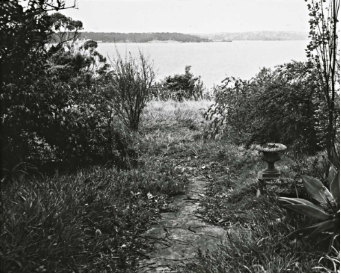
Figure 1‑21: Overgrown lawns of Kirribilli House looking east (Source: Department of Housing and Construction Landscape Architects ACT Region, 1986 and National Archives of Australia Series 10982 Item HP02, Page 6 of 10)
Another 1956 photograph included within the 1986 Grounds CMP report shows the western side of the house with a fastigiate poplar, amongst other deciduous plantings, opposite the western entry (Figure 1‑22). A further view from 1956 (also included in the 1986 Grounds CMP) records the eastern end of the house from below the outcropping. The pine closest to the house (and next to the former Flame Tree) appears to be a Kauri Pine (Agathis robusta) from its distinctive branching habit (Figure 1‑23).
A black and white picture of Kirribilli House with leafless trees in front and large bushes on the ground
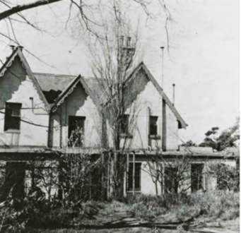
Figure 1‑22: Western end of Kirribilli House and deciduous plantings
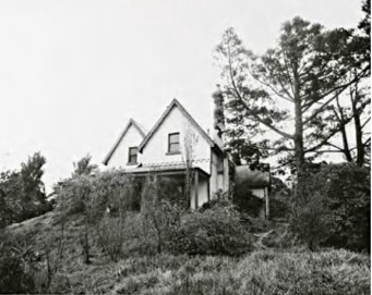
Figure 1‑23: Eastern end of house with Kauri Pine
The next group of photographs were taken soon after the dramatic changes when the staff wing was added, and the northern drive loop was built – both requiring drastic changes of levels.
All five of the views (National Archives of Australia A1200/18/L 24661; L 24657; L24658; L24659; and L 24662) show that earlier trees in the vicinity of the new drive loop were retained – more likely to retain as much privacy as possible from the adjacent block of units. However, in the case of the two large trees nearest the house – the Flame Tree and possible Kauri Pine – and even the Angophora costata further up the driveway, the trunks would have been filled enough to affect the long-term viability of the trees. As it happens, all three trees have now been removed.
Photograph L 24657 shows the view from near the garage looking towards the house in a sweep from the driveway to the new staff wing (Figure 1‑24). It reveals that the present large Macadamia tetraphylla had not been planted by 1957, a large (retained) tree survived opposite the 1920s addition to the northwest corner of the house and near the present location of the liquidambar there appears to be a young Araucarian pine. The same image shows the section pavement between the driveway and the garage to be of crazy-paved stone while the drive is gravelled with a low, possibly concrete, edge and drain. This image and L24568 demonstrate that it was possible to see directly to the harbour from the driveway with Fort Denison clearly visible in the latter view (Figure 1‑24).
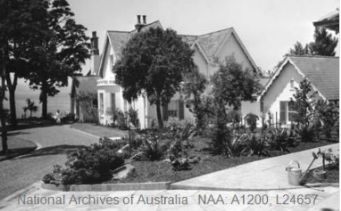
Figure 1‑24: Kirribilli House from the garage (Source: National Archives of Australia, Series A1200 Item L24657)
Photographs L24658 (Figure 1‑25) and L 24659 (Figure 1‑26) indicate the Frangipanis (Plumeria sp.) were planted next to the main porch and generous lawns were maintained to the north of the house. Photographs L24661 (Figure 1‑27) and L 24662 (Figure 1‑28) show views of the eastern side of the house (including the awkward 1950s addition to the north-east corner) and confirm the removal of the old steps from off the verandah and the addition of a new flight down the extended bank to a stone landing with stepping stones beyond.
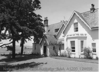
Figure 1‑25: Northern elevation of Kirribilli House. Note Fort Denison clearly in the background (Source: National Archives of Australia, Series A1200, Item L24658)
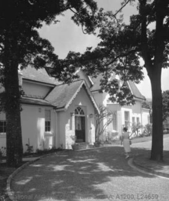
Figure 1‑26: Northern elevation of Kirribilli House. Note frangipanis adjacent to porch (Source: National Archives of Australia, Series A1200, Item L 24659)
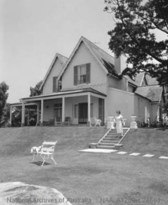
Figure 1‑27: Kirribilli House, eastern elevation (Source: National Library of Australia, Series A1200, Item L24661)
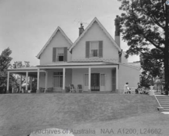
Figure 1‑28: Eastern elevation of Kirribilli House. Note awkward addition at right, beyond seated people (Source: National Archives of Australia, Series A1200, Item L24662)
The top of the new steps is flanked by a pair of urns similar to that shown in earlier archival photographs. However, while the bases are of a similar patterning the urns are quite different.[108] (The urn in the archival photography is more upright and has a floral catenary motif around it, whereas the present site examples have a simpler, fluted pattern.) Both images also show part of the central rock outcropping in the extreme foreground – this is the single slab of rock with the rectangular rebate – while L24661 (Figure 1‑29) actually records that next to this outcrop there is a large section of darker toned grass indicating the position of the earlier boarding at ground level.
Another 1957 photograph, included in the 1986 Grounds CMP report (Photograph sheet 7) records the southern side of the house with the retained (or re-laid) flagged path leading to Admiralty House and a recent Jacaranda nearby as well as a young Ginkgo biloba in the acute space made by the path, virtually next to the verandah (Figure 1‑30).
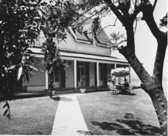
Figure 1‑29: Southern side of Kirribilli House, showing path leading to Admiralty House (Source: Department of Housing and Construction Landscape Architects ACT Region, 1986, also National Archives of Australia, Series A10982 HP02 page 5 of 10)
The aerial photograph indicated to be about 1968 shows a number of changes to the lower grounds - namely the introduction of a large pond with associated plantings to the south-east corner and, significantly, the possible loss of a large fig tree in the same location. The photograph certainly shows that the large spreading canopy of the old tree has gone but whether this was a result of complete removal or simply a drastic pruning back (as happened to the former 1850s fig trees within the Cahill Expressway) is impossible to determine from this image.
The new pond appears to have been installed two years earlier suggesting a date within the term of office of Harold Holt (1966-1967). The photograph also shows the boat harbour and saltwater pool enclosure layout remains intact.
The first photograph (from Photograph Sheet 5) shows the western courtyard with the poplar (probably Populus italica) near the western façade and the present Liquidambar (Liquidamber styraciflua) to the extreme right. While the poplar appears to have been planted in the immediate post-war years, the latter tree may have been introduced in the 1960s.
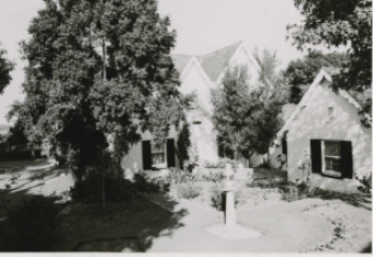
Figure 1‑30: Western courtyard with poplar and liquidambar (Source: Department of Housing and Construction Landscape Architects ACT Region, 1986 and National Archives of Australia, Series A10982, Item HP02 Page 3 of 10)
Two photographs (Photograph Sheet 10) (North east lawns (Source: Department of Housing and Construction Landscape Architects ACT Region, 1986 and National Archives of Australia, Series 10982 Item HP02 Page 8 of 10) and Lower lawns Source: (Department of Housing and Construction Landscape Architects ACT Region, 1986 and National Archives of Australia, Series 10982 Item HP02 Page 8 of 10)(Figure 1‑31 and Figure 1‑32) record conditions across the northeast and lower lawns with the former indicating that the 1957 stepping stones off the landing at the new steps have been replaced by a stone path with a traditional cut edge to the adjacent lawn and that cannon balls have been placed on plinths at the bottom of the steps. The view beyond is generally unobstructed though the present Hill’s fig Tree is beginning to dominate the horizon indicating several decade’s growth
The second of these images shows the view from the northeast pair of urns (planted with miniature conifers) looking down over the large pond in the south-east corner of the site where surrounding conifers (including Swamp Cypress [Taxodium distichum]) have already begun to challenge the scale of the pond and dwarf it. The photograph also seems to confirm the demise of the former old fig tree at this location.
The next two photographs (Photographic Sheet 11) records views along an earlier pathway passing just above the existing Hill’s Fig Tree and from between the oldest camellia and a Bull Bay at the southern boundary looking back to the house. In the first photograph, the path is shown much narrower than its current width and a timber-battened seat is positioned between the fig tree and the clump of Phoenix reclinate. A vista (with distance overexposed) is suggested to the south and just misses the block of units across the reserve which otherwise dominates similar views (Figure 1‑33).

Figure 1‑33: Southern boundary (Source: Department of Housing and Construction Landscape Architects ACT Region, 1986 and National Archives of Australia Series 10982 Item HP02, Page 9 of 10)
The view from the old camellia shows basic steps leading to a ramping section of exposed rock outcrop (since paved over to assist access) with the gnarled multi-trunked Bull Bay leaning out to the north and the eastern house verandah above the grassed bank (Figure 1‑34).
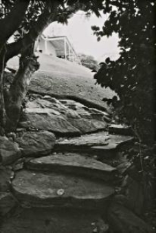
Figure 1‑34: From south, looking back at Kirribilli House (Source: Department of Housing and Construction Landscape Architects ACT Region, 1986 and National Archives of Australia Series 10982 Item HP02, Page 9 of 10)
The final group of images from 1977 (Photograph Sheet 14) shows views at the eastern parts of the site. One indicates that the ashlar stone breakwater forming the saltwater pool was still intact at this date and others shown the area near the existing Monterey Cypress – one with a seat in one of the rock-lined spaces nearby.
Although only a few years apart from the preceding photographic survey the mid-1980s photography provided a more thorough coverage, especially for the 1986 landscape review by the Department of Housing and Construction.
The first images from this period in the 1986 report (from Photograph Sheet 4) cover the main entry precinct and show that the present large Macademia tetraphylla is well developed with about fifteen to twenty years’ growth. The 1985 image of the northern arrival space shows the Flame Tree relatively bare of foliage and a maturing tree (presumed to be an Angophora costata from the 1979 survey) halfway up the drive though missing in the 1986 view of the same area.
The 1985 photograph also shows the existing Backhousia citriodora as a young tree (presumably replacing the now missing Kauri Pine) and that the previous poplar to the western entry has been removed and is confirmed in the 1986 photography (Photography Sheet 5) (Figure 1‑35).
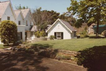
Figure 1‑35: Western entry (Source: Department of Housing and Construction Landscape Architects ACT Region, 1986 and National Archives of Australia Series 10982 Item HP02, Page 3 of 10)
The latter set also shows the western courtyard with a Claret Ash (noted in the 1986 report for imminent removal) and the raised grass section looking particularly bare apart from the Liquidambar (it is understandable from this that the 1986 recommended the planting of the existing Plumbago hedge along the driveway) (Figure 1-36).
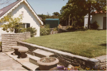
Figure 1‑36: Western courtyard with raised lawn (Source: Department of Housing and Construction Landscape Architects ACT Region, 1986 and National Archives of Australia Series 10982 Item HP02, Page 3 of 10)
Along the southern verandah the 1985 photography records the 1950s Ginkgo biloba as having substantial growth having reached about the height of the dormer ridges and the 1986 photography seems to show the same tree assailed by the English Ivy (Figure 1-37). At the north-east side of the house a 1986 image shows the foliage of the present Backhousia citriodora. More 1985 images (Photographic Sheet 9) show the existing Monterey Cypress and Jelly Palm beginning to frame views to the harbour while the dense foliage of a New Zealand Christmas Bush (Metrosideros excelsa) (now removed) looms into the horizon from near the central rock formation (Figure 1-38).
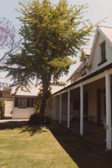
Figure 1‑37: Ginkgo biloba along southern verandah (Source: Department of Housing and Construction Landscape Architects ACT Region, 1986 and National Archives of Australia Series 10982 Item HP02, Page 5 of 10)
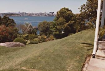
Figure 1‑38: Vegetation framing harbour views to the east (Source: Department of Housing and Construction Landscape Architects ACT Region, 1986 and National Archives of Australia Series 10982 Item HP02, Page 7 of 10)
Views to the north-east (Photography Sheet 10) show a relatively unimpeded panoramic prospect apart from the rising canopy of the Hill’s Fig Tree. At the extreme left the Firewheel Tree (Stenocarpus sinuatus) at the northern boundary may be visible together with the canopy of the Lillipilli (Syzygium sp.) and some of the foliage from the Deodar Cedar (Cedrus deodara) (Figure 1‑39).
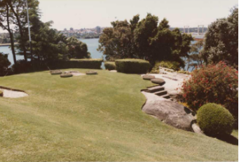
Figure 1‑39: Views north-east (Vegetation framing harbour views to the east (Source: Department of Housing and Construction Landscape Architects ACT Region, 1986 and National Archives of Australia Series 10982 Item HP02, Page 8 of 10)
The final set (Photographic Sheet 14) confirms the presence of Agave americana ‘Variegata’ in 1986.
A coloured oblique aerial photograph (National Archives of Australia A6135, K 10/3/80/4) shows that a set of steps has been added (possibly in the 1970s – certainly after about 1968) at the lower southern end of the large central rock formation. The view also shows a continuous dense band of trees along the northern boundary and the Flame Tree within the grassed drive loop.
Finally, several photographs from 1987 further record the status of parts of the grounds. The first two (National Archives of Australia A6135 K6/110/87/23 and K6/10/87/21) show that the recommended Plumbago hedge of the 1986 report had yet to be implemented and reveal a very austere ground plane throughout the main arrival area, a considerable contrast to that which existed at the beginning of the 20th century and certainly out of character with the mostly intact fine Gothic house.
The front of the house is shown with barely any plantings; mostly grassed edges, some annuals, and a pair of noticeably out of scale pots at the entry porch. Only the few remaining mature trees at the northern side provide some relief and privacy. The maturing Macadamia and Backhousia trees are shown as strategically important placements and a Jacaranda (now removed) is visible behind the staff link roof.
The 2007 (Figure 1‑40) colour aerial photography shows the present defoliated Camphor laurel at the northern boundary to be fully in leaf and providing an excellent visual screen, together with the former large Lemon-scented Gum, to residences across the road. The image also shows the former Flame Tree in front of the house, along with a substantial gap to the northeast where another Camphor Laurel was previously removed.
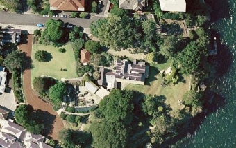
Figure 1‑40: Aerial photograph of Kirribilli House, March 2007 (Source: Google Earth Pro, Sinclair Knight Merz)
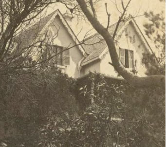
Figure 1‑41: Photographic print, mounted stereoview, Kirribilli looking south, published by William Hetzer, Sydney, 1860-1863 (Source: Powerhouse Museum Collection, 1019_15 close up)
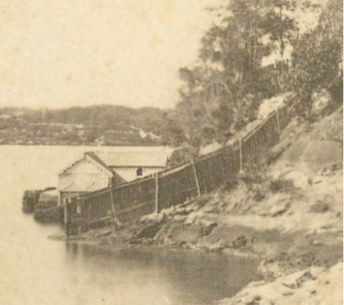
Figure 1‑42: Photographic print, mounted stereoview, Kirribilli looking south, published by William Hetzer, Sydney 1860-1863 (Source: Powerhouse Museum Collection, 1019_14#3)
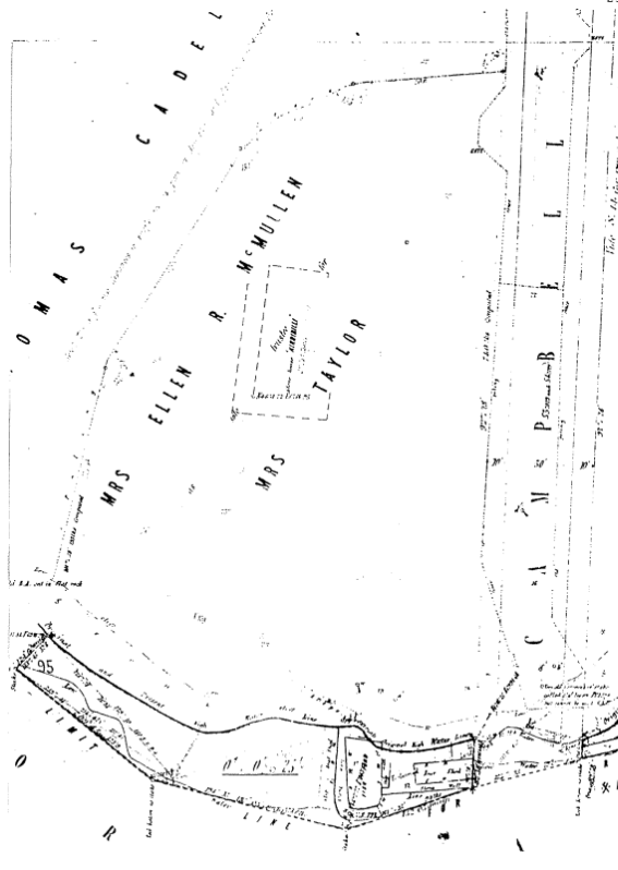
Figure 1‑43: 1883 Plan of Land at Kirribilli Point (North Sydney Library)
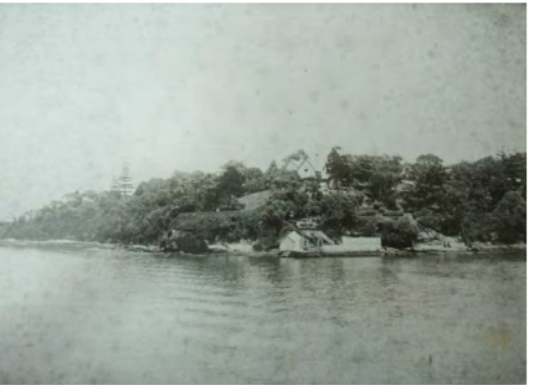
Figure 1‑44: 1890s SPF image (Source: Mitchell Library)
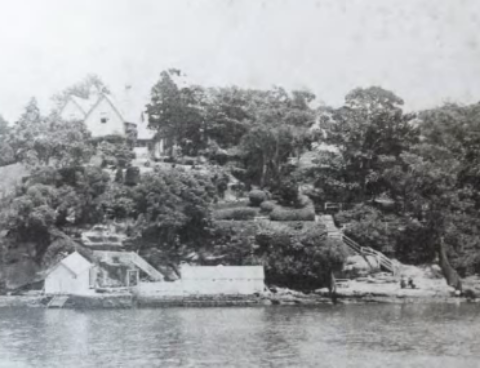
Figure 1‑45: 1890s SPF image (Source: Mitchell Library)
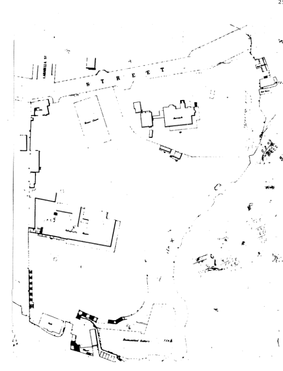
Figure 1‑46: 1892 Block plan map of North Sydney (North Sydney Library)
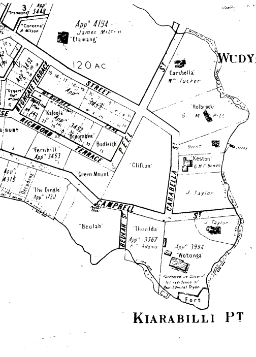
Figure 1‑47: c.1890-190 Portion of Higinbotham and Robinson Map of East St Leonards (North Sydney Library)
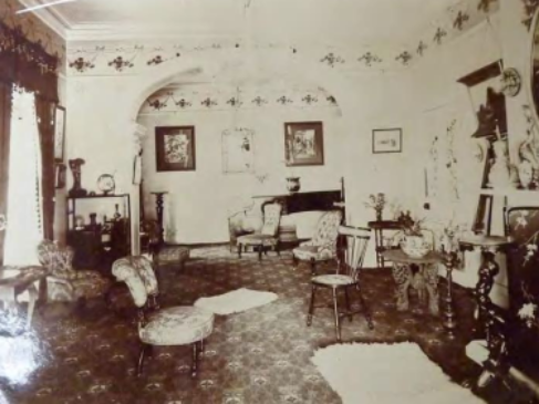
Figure 1‑48: Interiors c. 1913 (Source: Mitchell Library PXA548 – Kirribilli Album)
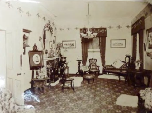
Figure 1‑49: Interiors c. 1913 (Source: Mitchell Library PXA548 – Kirribilli Album)
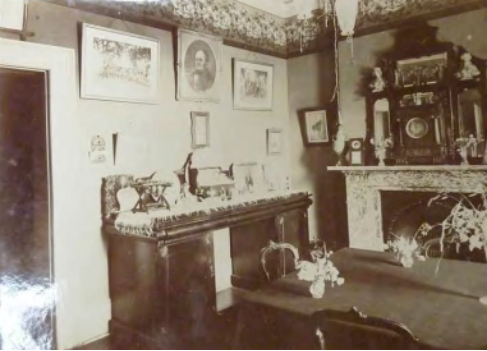
Figure 1‑50: Interiors c. 1913 (Source: Mitchell Library PXA548 – Kirribilli Album)
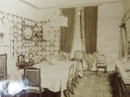
Figure 1‑51: Interiors c. 1913 (Source: Mitchell Library PXA548 – Kirribilli Album)
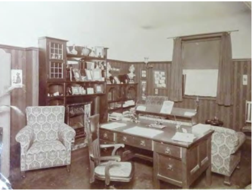
Figure 1‑52: Interiors c. 1913 (Source: Mitchell Library PXA548 – Kirribilli Album)
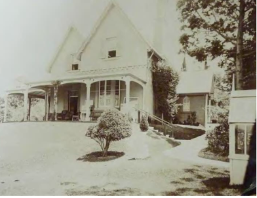
Figure 1‑53: c.1913 (Mitchell Library PXA548 – Kirribilli Album)
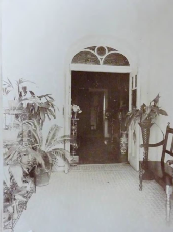
Figure 1‑54: c.1913 (Mitchell Library PXA548 – Kirribilli Album)
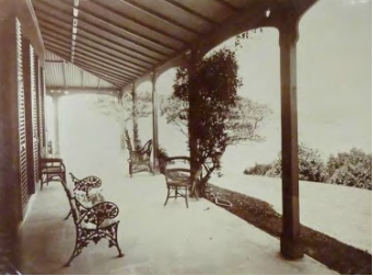
Figure 1‑55: c. 1913 (Mitchell Library PXA548 – Kirribilli Album)
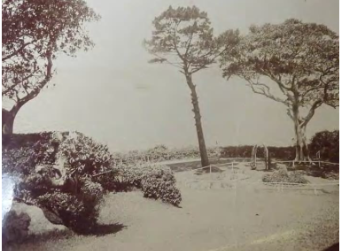
Figure 1‑56: c. 1913 (Source: Mitchell Library PXA548 – Kirribilli Album)
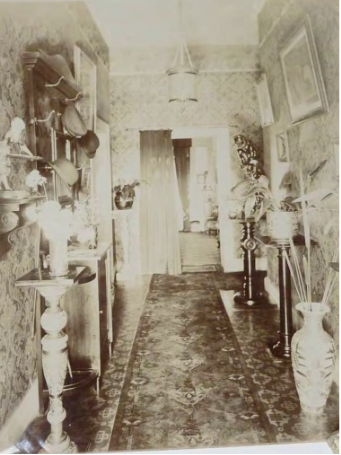
Figure 1‑57: c.1913 (Source: Mitchell Library PXA548 – Kirribilli Album)
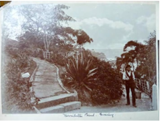
Figure B-3.23: 1900-1902 (Source: State Library of NSW, W H Davis Manuscript Collection, PXA4467)
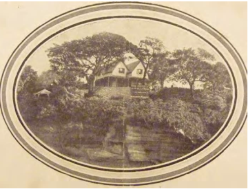
Figure 1‑58: Detail of Richardson & Wrench Sales Brochure, c. 1920
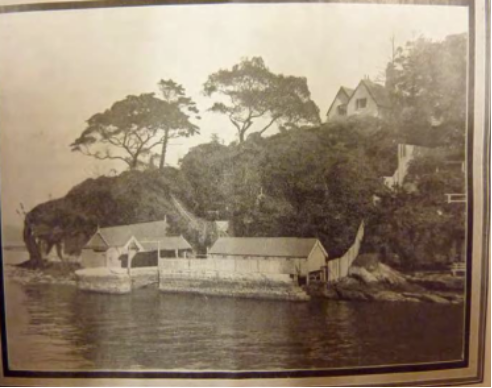
Figure 1‑59: Detail of Richardson & Wrench Sales Brochure, c. 1920
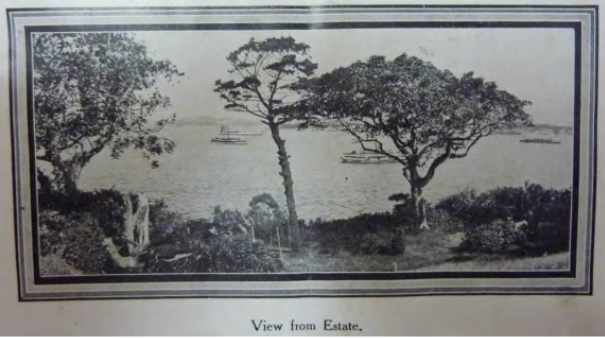
Figure 1‑60: 1920s Richardson & Wrench Sales Brochure
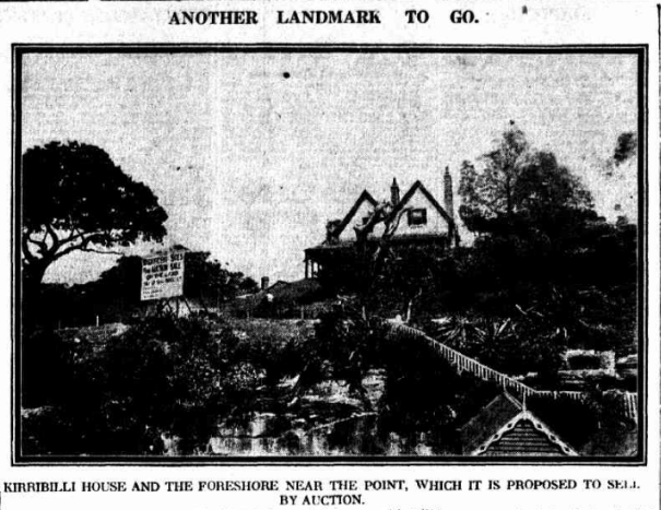
Figure 1‑61: Daily Telegraph, Sydney, 14 January 1920, p. 9 (Source: https://trove.nla.gov.au/newspaper/page/25783950)
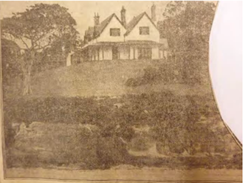
Figure 1‑62: 5 March 1922, Sydney Telegraph (Source: royal Australian Historical Society, Watson Press Clippings, Vo. 19, pp 110-111)

Figure 1‑63: Detail of photograph of the Pastoral Finance Association Building (to the left of Admiralty House out of frame) on Kirribilli Point, c. 1921, taken by Milton Kent (Source: State Library of NSW, ON 447/Box 123
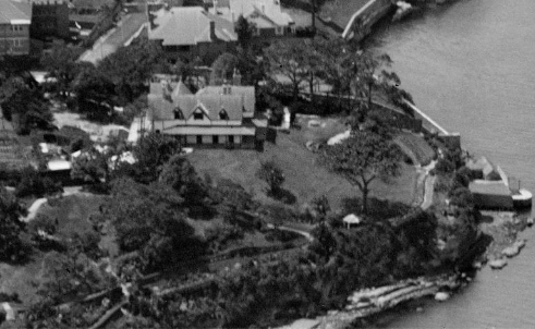
Figure 1‑64: Detail of above photograph showing Kirribilli House.
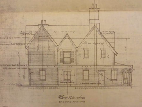
Figure 1‑65: 18 January 1921 – Commonwealth Works Department
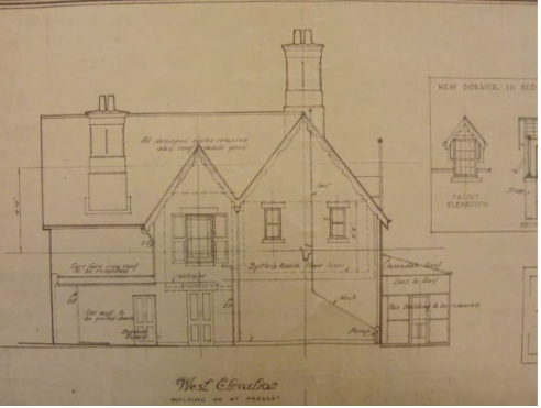
Figure 1‑66: 18 January 1921 – Commonwealth Works Department
Figure 1‑67: 18 January 1921 – Refer to Volume 3
Figure 1‑68: 18 January 1921 – Refer to Volume 3
Figure 1‑69: 1936 Floor Plans – Refer to Volume 3
Figure 1‑70: 1936 Hot water plan – Refer to Volume 3
Figure 1‑71: 1955 Measured drawing - Refer to Volume 3

Figure 1‑72: 1956, Kirribilli House, Sydney Photographic Record, National Archives of Australian Series A10982, 1986 Album barcode 4027343#2
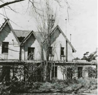
Figure 1‑73: 1956 Kirribilli House, Sydney Photographic Record, National Archives of Australia Series A10982, 1986 Album barcode 4027343#3
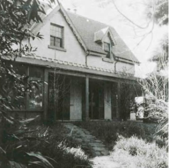
Figure 1‑74: 1956, Kirribilli House, Sydney Photographic Record, National Archives of Australia Series A10982, 1986 Album
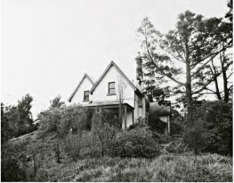
Figure 1‑75: 1956, Kirribilli House, Sydney Photographic Record, National Archives of Australia series A10982, 1986 Album barcode 4027343#6
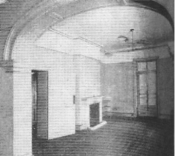
Figure 1‑76: 1956, Drawing Room – Australian House and Garden, August 1958

Figure 1‑77: 1956 – 57 Contract working drawings, 1956 – 58 Drawings – National Archives

Figure 1‑78: 1956 – 57 contract working drawings, 1956 – 58 drawings – National Archives

Figure 1‑79: 1956 – 57 Contract working drawings, 1956 – 58 Drawings – National Archives
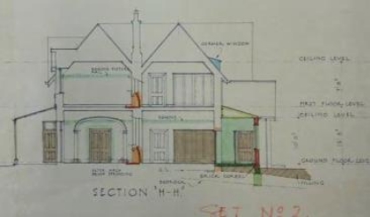
Figure 1‑80: 1956 – 57 Contract working drawings, 1956 – 58 Drawings – National Archives
Figure 1‑81: 1956 – 57 Contract working drawings, 1956 – Refer to Volume 3
Figure 1‑82: 1956 – 57 Contract working drawings, 1956 – 58 Drawings – Refer to Volume 3
Figure 1‑83: 1956- 57 Contract working drawings, 1956 – 58 Drawings – Refer to Volume 3
Figure 1‑84: 1956 Restorations, Archival Plans – Refer to Volume 3
Figure 1‑85: 1956 Restoration plans – Refer to Volume 3
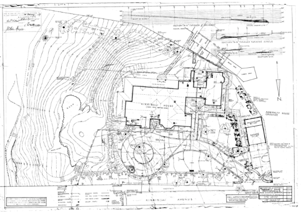
Figure 1‑86: 1956 Site layout, Archival Plans – Refer to Volume 3
Figure 1‑87: 1956 Gatehouse, Archival Plans – Refer to Volume 3
Figure 1‑88: 1956 – 57 Contract working drawings – Refer to Volume 3
Figure 1‑89: 1956 kitchen, archival plans – Refer to Volume 3
Figure 1‑90: 1956 Electrical, Archival Plans, PM&C
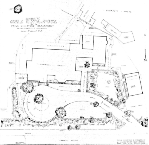
Figure 1‑91: 1956 Entrance driveway, Archival Plans, PM&C
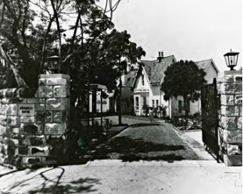
Figure 1‑92: 1957, Kirribilli House, Sydney Photographic Record, National Archives of Australia, Series A10982, 1986 Album barcode 4027343#1
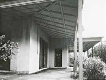
Figure 1‑93: 1957, Kirribilli House, Sydney Photographic Record, National Archives of Australia, Series A10982, 1986 Album barcode 4027343#7
Figure 1‑94: 1957 Ground floor toilets, Archival Plans– Refer to Volume 3
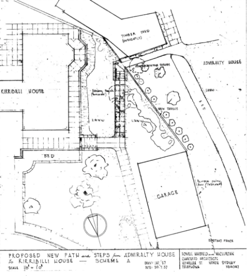
Figure 1‑95: 1957 Path and steps 1, Archival Plans, PM&C

Figure 1‑96: Ground floor main bedroom, Australian Women’s Weekly, 18 December 1957, page 8
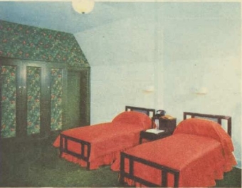
Figure 1‑97: Main upstairs bedroom, Australian Women’s Weekly, 18 December 1957, p. 8

Figure 1‑98: Ground floor single bedroom, Australian Women’s Weekly, 18 December 1957, p. 8
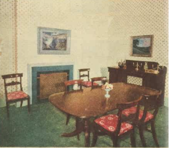
Figure 1‑99: Dining room. The chairs are from Ireland, however the table was purchased in Australia. Australian Women’s Weekly, 18 December 1957, p. 8

Figure 1‑100: Second floor study, Australian Women’s Weekly, 18 December 1957, p. 8
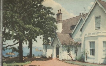
Figure 1‑101: Northern elevation, looking east. Australian Women’s Weekly, 18 December 1957, p. 9

Figure 1‑102: Reception rooms. It is noted that the Queen Anne walnut secretaire was originally from Dublin Castle and matches two now in Windsor Castle. Australian Women’s Weekly, 18 December 1957, p. 9
Figure 1‑103: 1958 as-built architectural drawings, 1956 – Refer to Volume 3
Figure 1‑104: 1958 as-built architectural drawings, 1956 – Refer to Volume 3
Figure 1‑105: 1958 as-built architectural drawings, 1956 – Refer to Volume 3
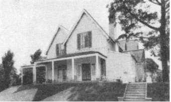
Figure 1‑106: c.1958, Kirribilli House – Australian House and Garden, 1958
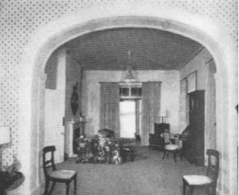
Figure 1‑107: c. 1958, Drawing Room – Australian House and Garden, August 1958
Figure 1‑108: 1960 staff quarters 1– Refer to Volume 3
Figure 1‑109: 1960 staff quarters 2– Refer to Volume 3
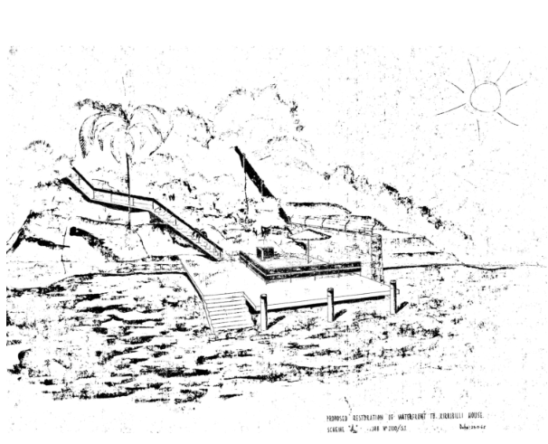
Figure 1‑110: 1965 Proposed waterfront restoration, Archival Plans PM&C
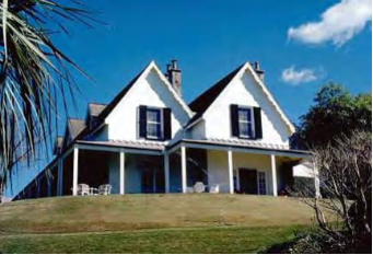
Figure 1‑111: September 1977 – Australian Heritage Photograph Database
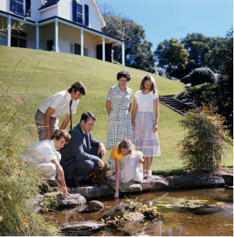
Figure 1‑112: Prime Minister Malcolm Fraser and his family at the fish pond in the grounds of Kirribilli House, 1978 (Source: National Archives of Australia, Series A6135, Item ID 203051590)
Figure 1‑113: History and growth from 1981 Masterplan– Refer to Volume 3
Figure 1‑114: History and growth from 1981 Masterplan– Refer to Volume 3
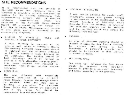
Figure 1‑115: Recommendations from 1981 Masterplan (Phillip Cox & Partners Pty Ltd, 1981:16)

Figure 1‑116: Proposed masterplan amalgamating the two sites, 1981 Masterplan (Phillip Cox & Partners Pty Ltd, 1981:17)
Figure 1‑117: Options from 1981 Masterplan– Refer to Volume 3
Figure 1‑118: Options from 1981 Masterplan– Refer to Volume 3

Figure 1‑119: Option A from 1981 Masterplan (Phillip Cox & Partners Pty Ltd, 1981:35)
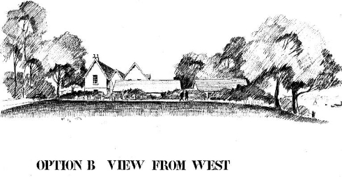
Figure 1‑120: Option B from 1981 Masterplan (Phillip Cox & Partners Pty Ltd, 1981:36)
Figure 1‑121: Options from 1981 Masterplan – Refer to Volume 3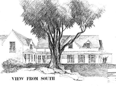
Figure 1‑122: Options from 1981 Masterplan (Phillip Cox & Partners Pty Ltd, 1981:39)
Figure 1‑123: 1982 minor works– Refer to Volume 3
Figure 1‑124: 1984-85 Works Program– Refer to Volume 3 – Refer to Volume 3
Figure 1‑125: 1984 Rear of garage – Refer to Volume 3
Figure 1‑126: 1984 Rear of garage – Refer to Volume 3
Figure 1‑127: 1985 Physical survey – Refer to Volume 3
Figure 1‑128: 1985 Physical survey – Refer to Volume 3
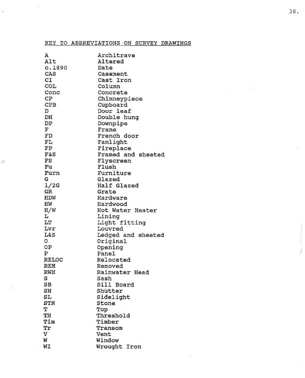
Figure 1‑129: 1985 Physical survey (Source: Clive Lucas, Stapleton & Partners Pty Ltd, Conservation Analysis and Draft Conservation Policy, p.38
Figure 1‑130: 1985 Physical survey – Refer to Volume 3

Figure 1‑131: 1985 Physical survey (Source: Clive Lucas, Stapleton & Partners Pty Ltd, Conservation Analysis and Draft Conservation Policy, p.42
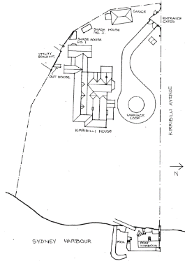
Figure 1‑132: 1985 Site Plan (Source: Clive Lucas, Stapleton & Partners Pty Ltd, Conservation Analysis and Draft Conservation Policy, p.43)
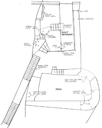
Figure 1‑133: 1985 Physical survey (Source: Clive Lucas, Stapleton & Partners Pty Ltd, Conservation Analysis and Draft Conservation Policy, p.44)

Figure 1‑134: 1985 Structural report (Source: Clive Lucas, Stapleton & Partners Pty Ltd, Conservation Analysis and Draft Conservation Policy, Appendix 6)
Figure 1‑135: 1985 Structural report – Refer to Volume 3
Figure 1‑136: 1986 Site drainage, Archival Plans PM&C
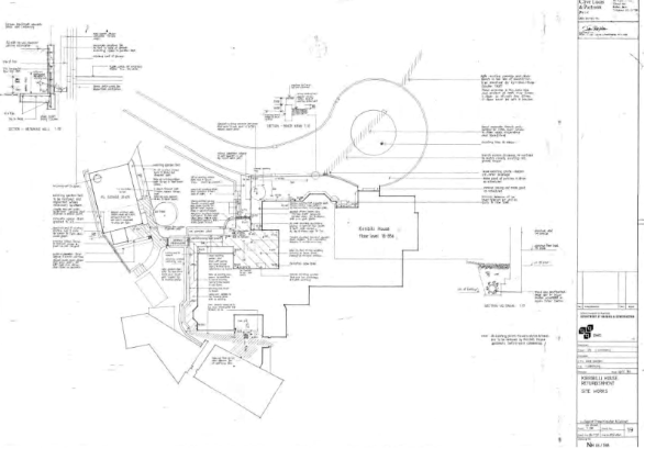
Figure 1‑137: 1986 Site Works, Archival Plans PM&C
Figure 1‑138: 1986 Floor joists – Refer to Volume 3
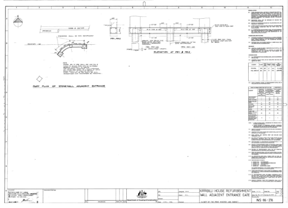
Figure 1‑139: 1986 Wall adjacent entrance gate, Archival Plans PM&C
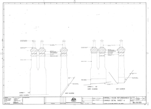
Figure 1‑140: 1986 Chimney detail, Archival Plans PM&C

Figure 1‑141: 1986 Chimney detail, Archival Plans PM&C
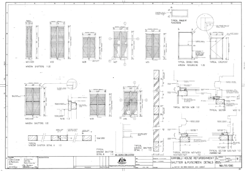
Figure 1‑142: 1986 Shutter and flyscreen detail – Archival Plans PM&C

Figure B-3.117: 1986 joinery detail, Archival Plans PM&C
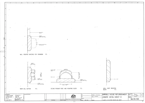
Figure B-3.118: 1986 joinery detail, Archival Plans PM&C
Figure B-3.119: 1986 Kitchen layout – Refer to Volume 3
Figure 1‑143: 1986 Bathroom layout – Refer to Volume 3
Figure 1‑144: 1986 Bathroom and store – Refer to Volume 3
Figure 1‑145: 1986 Utility building – Refer to Volume 3

Figure 1‑146: Title: “Government – Federal Parliament – the exterior of Kirribilli House in Sydney, New South Wales, 1987 Date: 1987 Barcode: 11461388 Series number A6135 Control symbol K6/10/87/20
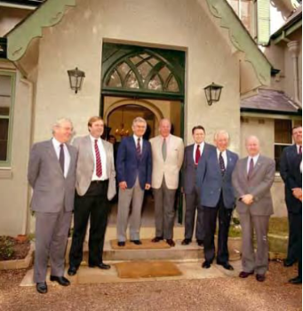
Figure 1‑147: Personalities – Bob Hawke – Group during visit of Schultz and Weinberger at Kirribilli House 1987, (NAA: 11655522 Series number A8746 Control symbol: KN26/6/87/6)

Figure 1‑148: President Bush with Prime Minister Paul Keating at Kirribilli House [picture]/Dept. Foreign Affairs and Trade, Overseas Information Branch, 1992 nla.obj-140414794/PIC P505/39 LOC Portrait Box K
Figure 1‑149: Pryor, Geoff. 1996, “Very nice – but whatever will they say in Melbourne!” [John Howard decides to live at Kirribilli House in Sydney more frequently than either of his predecessors] [picture]/Pryor http://nla.gov.au/nla.obj-156976942>
The following list has been extracted from https://australianpolitics.com/executive/pm/prime-ministers-since-1901
Name | Party | Began | Left | Length | Method of departure |
Barton, Edmund | Protectionist Party | 01-01-01 | 24-09-03 | 2 years, 8 months, 24 days | Appointed Justice of the High Court |
Deakin, Alfred | Protectionist Party | 24-09-03 | 27-04-04 | 7 months, 4 days | Resigned following House Amendment of Conciliation and Arbitration Bill |
Watson, John Christian | Australian Labor Party | 27-04-04 | 17-08-04 | 3 months, 21 days | Resigned following House Amendment of Conciliation and Arbitration Bill and Governor=General’s Refusal to Dissolve House |
Reid, George Houston | Free Trade Party | 18-08-04 | 05-07-05 | 10 months, 18 days | Resigned following House Amendment of Address-in-Reply and Governor-General’s Refusal to Dissolve House |
Deakin, Alfred | Protectionist Party | 05-07-05 | 13-11-08 | 3 years, 4 months, 9 days | Defeated on Floor of House |
Fisher, Andrew | Australian Labor Party | 13-11-08 | 02-06-09 | 6 months, 21 days | Resigned following Defeat on Floor of House and Governor-General’s refusal to Dissolve House |
Deakin, Alfred | Liberal Party of Australia | 02-06-09 | 29-04-10 | 10 months, 28 days | Defeated at General Election |
Fisher, Andrew | Australian Labor Party | 29-04-10 | 24-06-13 | 3 years, 1 month, 26 days | Defeated at General Election |
Cook, Joseph | Liberal Party of Australia | 24-06-13 | 17-09-14 | 1 year, 2 months, 25 days | Defeated at General Election |
Fisher, Andrew | Australian Labor Party | 17-09-14 | 27-10-15 | 1 year, 1 month, 11 days | Resigned, appointed High Commissioner to London |
Hughes, William Morris | Australian Labor Party/Nationalist Party | 27-10-15 | 09-02-23 | 7 years, 3 months, 14 days | Deposed as Party Leader |
Bruce, Stanley Melbourne | Nationalist Party | 09-02-23 | 22-10-29 | 6 years, 8 months, 14 days | Defeated and lost seat at General Election |
Scullin, James Henry | Australian Labor Party | 22-10-29 | 06-01-32 | 2 years, 2 months, 16 days | Defeated at General Election following party split |
Lyons, Joseph Aloysius | United Australia Party | 06-01-32 | 07-04-39 | 7 years, 3 months, 2 days | Died in office |
Page, Earle Christmas Grafton | Country Party | 07-04-39 | 26-04-39 | 20 days | Relinquished position to new UAP leader |
Menzies, Robert Gordon | United Australia Party | 26-04-39 | 29-08-41 | 2 years, 4 months, 4 days | Resigned |
Fadden, Arthur William | Country Party | 29-08-41 | 07-10-41 | 1 month, 9 days | Defeated on Floor of House |
Curtin, John | Australian Labor Party | 07-10-41 | 05-07-45 | 3 years, 8 months, 29 days | Died in office |
Forde, Francis Michael | Australian Labor Party | 06-07-45 | 13-07-45 | 8 days | Relinquished position to new Labor leader |
Chifley, Joseph Benedict | Australian Labor Party | 13-07-45 | 19-12-49 | 4 years, 5 months, 7 days | Defeated at General Election |
Menzies, Robert Gordon | Liberal Party of Australia | 19-12-49 | 26-01-66 | 16 years, 1 month, 8 days | Retired |
Holt, Harold Edward | Liberal Party of Australia | 26-01-66 | 19-12-67 | 1 year, 10 months, 23 days | Missing, Presumed Drowned |
McEwan, John | Country Party | 19-12-67 | 10-01-68 | 23 days | Relinquished position to new Liberal Leader |
Gorton, John Grey | Liberal Party of Australia | 10-01-68 | 10-03-71 | 3 years 2 months | Technically resigned as leader but effectively deposed |
McMahon, William | Liberal Party of Australia | 10-03-71 | 05-12-72 | 1 year, 8 months, 25 days | Defeated at General Election |
Whitlam, Edward Gough | Australian Labor Party | 05-12-72 | 11-11-75 | 2 years, 11 months, 7 days | Commission Terminated by Governor-General |
Fraser, John Malcolm | Liberal Party of Australia | 11-11-75 | 11-03-83 | 7 years, 4 months | Defeated at General Election |
Hawke, Robert James Lee | Australian Labor Party | 11-03-83 | 20-12-91 | 8 years, 9 months, 9 days | Deposed as Party Leader |
Keating, Paul John | Australian Labor Party | 20-12-91 | 11-03-96 | 4 years, 2 months, 20 days | Defeated at General Election |
Howard, John Winston | Liberal Party of Australia | 11-03-96 | 03-12-07 | 11 years, 8 months, 22 days | Defeated and Lost Seat at General Election |
Rudd, Kevin Michael | Australian Labor Party | 03-12-07 | 24-06-10 | 2 years, 6 months, 21 days | Deposed as Party Leader |
Gillard, Julia Eileen | Australian Labor Party | 24-06-10 | 27-06-13 | 3 years, 3 days | Deposed as Party Leader |
Rudd, Kevin Michael | Australian Labor Party | 27-06-13 | 18-09-13 | 2 months 22 days | Defeated at General Election |
Abbott, Anthony John | Liberal Party of Australia | 18-09-13 | 15-09-15 | 1 year, 11 months, 28 days | Deposed as Prime Minister |
Turnbull, Malcolm Bligh | Liberal Party of Australia | 15-09-15 | 24-08-18 | 2 years, 11 months, 9 days | Deposed as Party Leader |
Morrison, Scott John | Liberal Party of Australia | 24-08-2018 | 23-05-22 | 3 years, 8 months, 30 days | Defeated at General Election |
Albanese, Anthony Norman | Australian Labor Party | 23-05-2022 | - |
|
|
(from Clive Lucas, Stapleton & Partners Pty Ltd, 1986, Conservation Analysis and Draft Conservation Policy, pp.3-20)
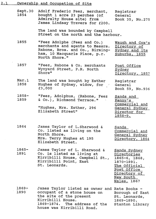
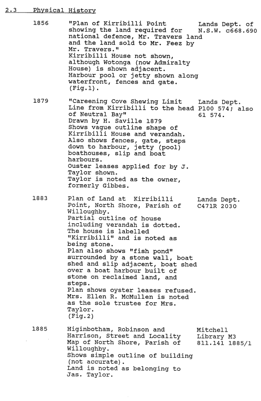
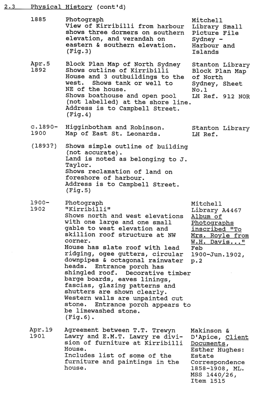
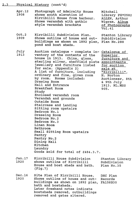
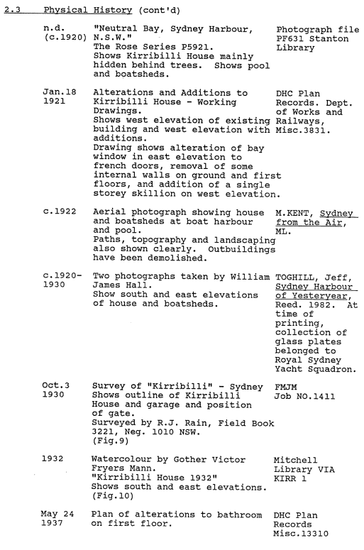


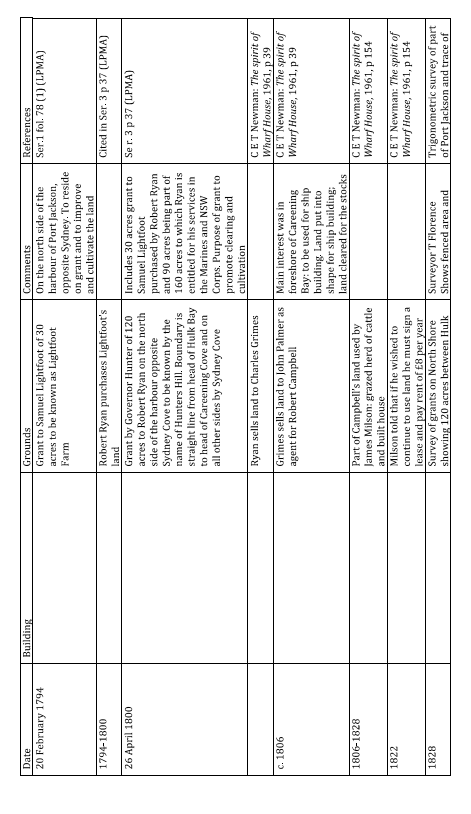
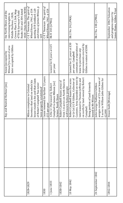

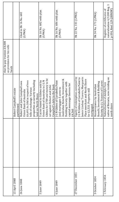
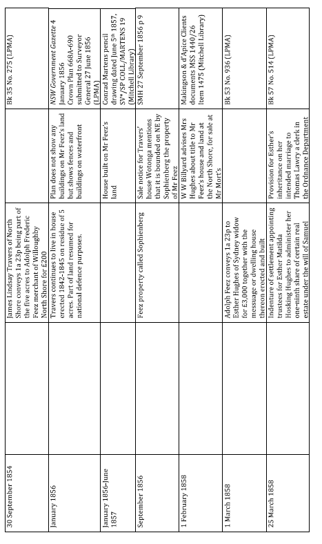
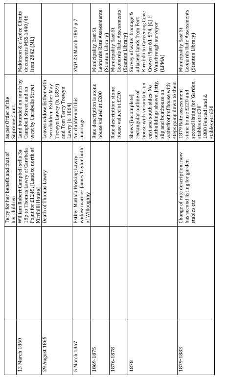
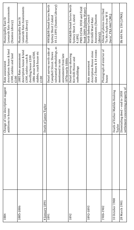
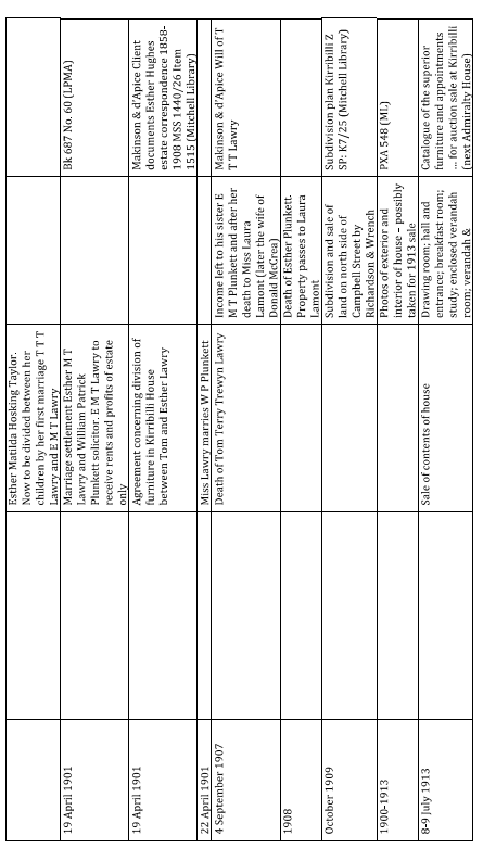
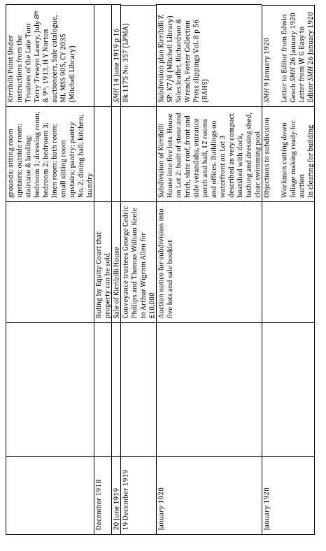
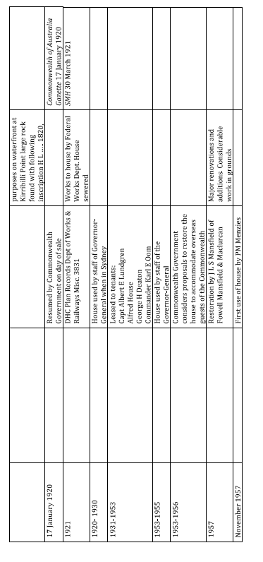
Kirribilli House: Owners and occupants 1806-2023
Date | Owner | Occupier |
c. 1806 – 1846 | Robert Campbell owns 120 acres on the North Shore | May 1842 Five acres with harbour frontage leased by Robert Campbell to J G N Gibbes |
1846-1848 | Heirs of Robert Campbell |
|
1848 | Union Bank of Australia | Property given by Campbell’s heirs as security to Union Bank of Australia for bills of exchange |
1848-1849 | J G N Gibbes | 1848 Five acres sold by Bank to lessee Gibbes to cover Campbell debts |
1849-1854 | Australian Benefit, Investment & Building Society | Property mortgaged by Gibbes to Australian Benefit, Invsetment & Building Society 1851 Equity of redemption on five acres at Carrabella Point sold by Gibbes to J L Travers |
September – October 1854 | James Lindsay Travers | Property reconveyed to Travers by Australian Benefit, Investment & Building Society |
September 1854 – March 1858 | Adolph Frederic Feez | Travers sells 1 acre, 23 perches of the five acres to Adolph Feez. Property called Sophienberg. House built c. 1856 – 1857. |
March 1858 | Mrs Esther Hughes | Property (now with house) sold by Feez to Mrs Hughes for £3,000 |
1858-1901 | Property held in trust for Esther Matilda Hosking Hughes (Mrs Lawry/Mrs Taylor) and her children | 1858-1865 Esther & Thomas Lawry and their children |
1860-1909 | Thomas Lawry and his children | Land on north side of Campbell Street owned in conjunction with Kirribilli House |
1901 | Esther Lawry & Thomas T T Lawry | Properties held in trust divided between Esther and Thomas Lawry |
1901-1907 | Thomas T T Lawry | 1901-1907 Thomas T T Lawry |
1907-1908 | Esther Plunkett (nee Lawry) | Occupant not known [possibly Miss Lamont?] |
1908-1919 | Mrs Laura Lamont/Mrs Laura McCrea 9in trust as beneficiary of Will of T T T Lawry) | 1908-1909 Miss Laura Lamont |
1909 |
| Land on north side of Campbell Street (purchased in 1860) sold and separated from Kirribilli House |
December 1918 |
| Equity Court rules that Lawry properties can be sold |
June 1919-January 1920 | A W Allen | House vacant during some of this period |
1920-2023 | Commonwealth of Australia | 1920-1930 Personal staff of the Governor-General September 2013 – September 2015 use of Kirribilli House as the primary residence of the Prime Minister while works to The Lodge were being undertaken October 2015 – 2023 Reversion to Prime Minister’s residence when in Sydney |
The following works were sourced from Dr Annable’s inputs from 1978-2015 as noted in Appendix G of GML’s 2016 HMP, and from 2015-2023 by information provided to AECOM by PM&C.
Date | Works | Notes | Source |
1978 | No significant work done since 1957 DH&C structural report |
| Official Establishments Trust First Annual Report 1979-1980, Canberra 1980, p. 4 |
1979-1980 | Refurbishing and redecorating main bedroom suite including wallpapering, repainting and associated repairs. First stage security measures completed. DH&C preparing long-term plan of restoration | A décor in keeping with the historical significance of Kirribilli House adopted for this work | Official Establishments Trust First Annual Report 1979-80, Canberra 1980, p. 4 Appendix 1 Objects on display at Kirribilli House, pp 26-27 |
1980-1981 | All State areas on ground floor comprehensively refurbished and redecorated. Included: replacement of some joists and floorboards; replastering; repainting, treatment of rising damp; rewiring, joinery; upgrading plumbing, wallpapering; replacement of dining room ceiling; replacement of lighting in dining room and guest toilet. Main guest suite on first floor refurbished including repainting and redecoration. Existing furniture stripped and repainted. Some new furniture and fittings provided in dining room, study and drawing room. New carpet throughout State areas of ground floor | Replacement of paling fence along northern boundary of Kirribilli Avenue to the harbour and replacement of metal gate in waterfront wall.
First stage of physical security measures completer | Official establishments Trust [2nd] Annual Report 1980-81, Canberra, 1982, p. 3 |
1981 | Kirribilli House Master Plan Report. Undertaken for DH&C by Phillip Cox and Partners Pty Ltd |
|
|
1981-1982 | Replacement of main sewer line, replacement of central hot water service. Department of Transport & Construction preparing detailed design of future service building to replace amenities building at rear of main residence | Repairs to dangerous sections of paths and paving | OET [3rd] Annual Report 1981-82, Canberra 1983, p. 4 Appendix D Objects on display at Kirribilli House pp 13-15 |
1982-1983 | Routine repairs and repainting costing about $18,000 – major component replacement of corrugated iron roof to ground floor verandah on east and south sides of house |
| OET [4th] Annual Report 1982-83, Canberra 1983, p. 3 Appendix B Objects on display at Kirribilli House pp 10-12 |
1983-1984 | Severe water leakage into house from roof due to deterioration of lead lining of a box gutter. Lead replaced with copper and supporting timbers and flashing being renewed as necessary |
| OET [5th] Annual Report 1983-84, Canberra 1985, p. 3 |
1984 | Kirribilli House Detailed Condition Survey. Undertaken for DH&C by Phillip Cox and Partners Pty Ltd |
|
|
1984-1985 | Quantity of new slates purchased for future work on roof | Repairs to sea water pool requiring maintenance to walls, filters and sea floor | OET [6th] Annual Report 1984-85, Canberra 1986, pp 5-6 |
1985-1986 | Serious structural deficiencies – rising and falling damp, leaking roof, crumbling stone and plaster surfaces and serious safety problems with electrical wiring and upstairs floor structure. DH&C commissioned Clive Lucas & Partners to prepare Conservation Analysis and Statement of Significance and to formulate schedule of work. In light of budgetary constraints imposed by government only urgent works done: roof restoration, installation of damp proof course, improved external drainage, repair to floor structure, walls and ceilings | DH&C requested to prepare Grounds C&MP to develop grounds and gardens more in keeping with the residence | OET [7th] Annual Report 1985-86, Canberra 1987, pp 6-7 |
1986 | Kirribilli House Conservation Analysis and Draft Conservation Policy. Prepared for DH&C by Clive Lucas and Partners Pty Ltd | Kirribilli House Grounds Conservation and Management Plan. Prepared for PM&C by DH&C Landscape Architects |
|
1986-1987 | Stage 2 completed: repairs and relating roof, installation of damp proof course, repairs to walls, floors and ceiling and repairs to electrical and hydraulic services. As a consequence, a number of rooms seriously affected and will need attention. | 1986 DH&C Conservation Analysis and Plan for grounds – to identify historical features and develop Plan of Management to consolidate and strengthen contribution of garden to historical setting of the house | OET[8th] Annual Report 1986-87, Canberra 1988, p2 & OET [9th] Annual Report 1987-88, Canberra 1988, p. 8 |
1987-1988 | Interior refurbishment arising from major structural works undertaken previously. DH&C commissioned David Spode to prepare designs for internal decoration in style of the 1880s consistent with earlier restoration of exterior of building. Based on historical research. Modifications to doors, pilasters and plaster mouldings, repairs to floors and joists. Lights, carpets and fittings including soft furnishings in major state areas affected by earlier structural work completed. | Primary function – official residence for overseas guest of the Australian Government and to provide satisfactory residence for the Prime Minister when in Sydney. Partial implementation of Stage 1 of garden plan (DH&C 1986) i.e. redefining garden beds and lawn areas, improving vistas to Sydney harbour from important vantage points and introducing plantings appropriate to period of house. | OET [9th) Annual Report 1987-88, Canberra 1988, pp. 7-8 Appendix F Historical review pp 25-28 |
1988 – 1989 | Restoration work begun in 1985-1986 completed in July 1988. Redecoration including light fittings, building works, carpets, wallpapering, upholstering and soft furnishings and repairs to guttering and drain pipes also completed early in 1988-89. | Some grounds development including removal of small fish pond and major tree surgery and removal of excess shrubs and tree growth. Since September 1988 again used for overseas dignitaries. | OET (10th) Annual Report 1988-89, Canberra 1989, p. 7 |
1898-1990 | Routine maintenance | Some grounds development. Resurfacing driveway and irrigation works. Replacement of boundary fence on Kirribilli Avenue and related security measures. | OET (11th) Annual Report 1989-90 Canberra 1990, p. 7 |
1990-1991 | Restoration of main residence and grounds now complete and no major works planned for new future | Repairs to stone paths and stairs, repairs to fences and gates and upgrading of pergolas and walkways | OET (12th) Annual Report 1990-91, Canberra 1991, p. 6 |
1991-1992 | No major works |
| OET (13th) Annual Report, 1991-92, Canberra 1992, p. 7 Appendix E Historical review and long-term strategy pp. 25-27 |
1992-1993 | Painting and cyclical repairs |
| OET (14th) Annual Report, 1992-93, Canberra 1993, p. 8 |
1993-1994 | Remedial internal painting and preventative maintenance |
| OET (15th) Annual Report 1993-94, Canberra 1994, p. 9 |
1994-1995 | Routine and preventative maintenance, painting of kitchen and staff areas, tiling and painting of gardener’s amenity building completed |
| OET (16th) Annual Report 1994-95, Canberra 1995, p. 7 |
1995-1996 | Prime Minister Howard decided to use Kirribilli House as main family residence. Some painting and maintenance work and several minor modifications undertaken in second quarter of 1996. Thermal detectors on first floor replaced with photo-optical detectors | Gift of two crystal chandaliers from Waterford Wedgewood (accepted by Mr Keating on behalf of the nation) to be installed in main sitting room. | OET (17th) Annual Report 1995-96, Canberra 1996, p. 11 |
1996-1997 | Some painting and maintenance work and number of minor modifications. New floor coverings, ovens and benches in kitchen. Additional security invigilation equipment installed. | Update of Gardens CMP requested | OET (18th) Annual Report 1996-1997, Canberra 1997 |
1997-1998 | Doorway between dining and drawing rooms widened and two rooms refurbished. Dinign room paper replaced, drawing room repainted and new carpet in both rooms. | Clive Lucas heritage architect for doorway project. Mrs Rosemary Lucas provided interior design consultancy services. Path lighting installed along southern stone pathway and steps. | OET (19th ) Annual Report 1997-1998 Canberra 1999, p. 9 |
1998-1999 | Main staircase reconstructed to 1880s position in central hallway. Hallway subsequently refurbished including painting and carpet replacement. Installation of air conditioning to first floor, refurbishing of principal bathroom, repairs and repainting of verandah posts and installation of safety lighting and stair rails to northern pathways |
| OET (20th) Annual Report 1998-1999 Canberra 1999, p. 9 |
1999-2000 | Reconstruction of remnants of previous main staircase completed | Report produced for Trust recommended that harbourside pool and adjacent boat dock be preserved as a ruin. Residual heritage value irrevocably diminished by substantial work undertaken in 1968. No prospect of pool or boat dock being used in the future. | OET (21st) Annaul Report 1999-2000, Canberra 2000, p. 10 |
2000-2001 | Only minor works. Some external painting in preparation for functions associated with Olympic and Paralympic Games | Rejuvenation of garden areas. Installation of bollards at front age and of inner security fence. | OET (22nd) Annual Report 2000-2001, Canberra 2001 p10 |
2001-2002 | Only minor works including internal painting. | Some repairs to sandstone paving in garden areas. | OET (23rd) Annual Report 2001-2002, Canberra 2002, p. 9 |
2002-2003 | Clive Lucas, Stapleton & Partners continue to provide advice on the building works. Only minor works undertaken and included refresher paint to external walls of residence and some minor repairs and upgrade to internal areas. | Service provider currently maintaining the gardens changed management, with little effect on provision of service. Only minor changes made to garden. | OET (24th) Annual Report 2002-2003, Canberra 2003, p. 12 |
2003-2004 | Following consultation with Clive Lucas, Stapleton and Partners and relevant heritage bodies, significant work undertaken on sewerage system and air conditioning installed in staff quarters. Construction of new guardhouse by Protective Security Coordination Centre to replace previously inadequate structure in consultation with Clive Lucas, Stapleton & Partners. New building reflects style of residence and provides more functional centre from which guards carry out their duties |
| OET (25th) Annual Report 2003-04, Canberra 2005, p. 12 |
2004-2005 | Scheduled maintenance and servicing of plant and equipment. | Due to drought, a Dais cotinfolia (pompom tree) and a Metasequoia glyptostroboides (dawn redwood) died and were removed. | OET (26th) Annual Report 2004-2005, Canberra 2005, p. 11 |
2005-2006 | No major work. Some external painting | Widening of driveway. Dead camphor laurel tree removed and assessment of viability of installing a rainwater tank in the grounds commenced. | OET (27th) Annual Report 2005-06, Canberra 2006, p. 10 |
2006-2007 | Several bathrooms refurbished with watersaving devices installed wherever possible.
Energy efficient light bulbs also installed. | In early 2007, two 1,500 litre water tanks installed to collect rainwater for use in the gardens. Approval obtained for the installation of a 23,000 litre PVC tank in the grounds and it is expected to be in place in the second half of 2007. Tank will eventually be screened by plantings consistent with the existing landscaping. Gardener has actively worked to reduce the water consumption in the gardens through the use of wetting agents, mulch and efficient watering systems. | OET Annual Report 2006 (online) |
2007-2008 | July 2007 the powder room bathroom refurbished which concluded the bathroom renovations at the residence. | Gardener has actively worked to reduce the water consumption in the gardens through the use of wetting agents, mulch and efficient watering systems.
July 2007, a 23,000 litre PVC tank was installed in the grounds. A rock wall was extended around the tank and some associated plantings, sympathetic to surrounding grounds were undertaken. | OET Annual Report 2007-2008 (online) |
2012 | Replacement of verandah posts
Replacement of metal grates to verandah underfloor ventilation |
| Advice to GML from Department of Finance |
2013 | Carpet replacement to first floor
Installation of gas fire in drawing room |
| Advice to GML from Department of Finance |
2014 | Introduction of turf cells for car parking adjacent to turning circle
Widening of the formed path and timber gate between the driveway and kitchen to allow for catering equipment
Replacement of lead cover flashings at abutments with external walls to east and west skillion slate roofing
Replacement of principal bedroom ensuite window
Replacement of kitchen annex terracotta tile ridge capping with rolled lead |
| Advice to GML from Department of Finance |
2015 | Stabilisation of sea cliff below property |
| Advice to GML from Department of Finance |
2016-2023 | The following items from AECOM’s site visit in March 2023 and documentary evidence provided by PM&C were noted: - Tree removal and new plants in the grounds - General repair works including repairs for guttering and rainwater goods, painting works - Repair to lath and plaster ceiling - Repairs to rotted timbers on verandah posts - Removal of ceiling in garage - Minor repairs to retaining walls in grounds |
|
|
Appendix H – Physical survey/Fabric survey – Kirribilli House
Assessment of NSW State Heritage List Criteria
The below table assesses the heritage significance of the site using seven different criteria set out in the NSW Heritage Manual and the guideline for Assessing Heritage Significance. The assessment demonstrates under each criterion if the item can demonstrate its importance.
Table 1: Assessment of heritage significance against State Heritage criteria
Criterion | Significance |
An item is important in the course, or pattern, of NSW’s cultural or natural history, OR An item is important in the course, or pattern of the local area’s cultural or natural history (local significance). | Kirribilli House and Garden is highly significant to the NSW cultural history as it has been the official Sydney residence of the Australian Prime minister since 1957 Kirribilli House and Garden evidence the early land grants to notable Sydney residents. Kirribilli House and garden reflects the lifestyle of prominent Sydney residents of the Victorian era The site is significant for its direct association with the People’s Open Air Space Movement, an early public campaign to protect harbourside development in the 1920s. |
(b) An item has strong or special association with the life or works of a person, or group of persons, of importance in NSW’s cultural or natural history (State significance); OR An item has strong or special association with the life or works of a person, or group of persons, of importance in the cultural or natural history of the local area (local significance). | Kirribilli House and Garden is significant for its association with Australian prime ministers since 1957. The site is also associated with several overseas and local dignitaries The garden is associated with Professor E G Waterhouse. The 1957 extension and restoration are associated with the architectural firm Fowell, Mansfield and Maclurcan The group the People’s Open Air Space Movement along with prominent members of the community including Dr Mary Booth (physician and welfare worker) and Senator H E Pratten (mining entrepreneur and politician). |
(c) An item is important in demonstrating aesthetic characteristics and/or a high degree of creative or technical achievements in NSW (or the local area) | Kirribilli House and Garden is significant for demonstrating the Victorian architectural style and picturesque qualities of the garden The setting of the Sydney Harbour, mature garden and the continued landscape that includes Admiralty House, contributes to the landmark qualities of Kirribilli House and garden within the harbour Panoramic views to and from the house and garden. |
(d) An item has a strong or special association with a particular community or cultural group in NSW (or the local area) for social, cultural or spiritual reasons. | Kirribilli House and Garden is significant as it is valued by the wider public of NSW The site is significant for its direct association with the People’s Open Air Space Movement, an early public campaign to protect harbourside development in the 1920s. |
(e) An item has potential to yield information that will contribute to an understanding of NSW’s cultural or natural history (or the cultural or natural history of the local area) | Kirribilli House and Garden has the potential to yield information through its archaeology and remnant indigenous landscape The extant bathing pool has been identified as one of the earliest harbour pools and may have the potential to yield further information about harbourside structures.
|
(f) An item possesses uncommon, rare or endangered aspects of NSW’s cultural or natural history (or the cultural or natural history of the local area); and | Kirribilli House and Garden is a rare substantial Gothic Victorian house remaining on the harbour The extant bathing pool is a rare item in NSW. |
(g) An item is important in demonstrating the principal characteristics of a class of NSW’s: Cultural or natural places; or Cultural or natural environments; (or a class of the local area’s) Cultural or natural places; or Cultural or natural environments. | Kirribilli House and Garden demonstrates the principal characteristics of the Gothic Victorian style of house and garden through its; irregular massing, modest scale, asymmetrical plan, dominant roof, prominent gables, steep pitched gables, slate roofing traceried bargeboards, tall chimneys, castellated parapet, bay windows, gabled dormers and timber farmed verandahs, textured masonry walling, quoining and Tudor arched opening, sweeping lawn, meandering stone paths, terracing, dry stone walling, fencing, dramatic views (panoramic and framed), floristic diversity including leaf form, colour, and texture. |
The assessment against the NSW SHR criteria demonstrates that Kirribilli House and Garden meets the threshold for listing in the NSW SHR (criterion a, b, c, d, e, f, and g).
Assessment of Potential National heritage values
For a place to be included on the NHL the Minister must be satisfied that the place meets one or more of the National Heritage Criteria. A place can only satisfy a National Heritage criterion if it has ‘outstanding heritage value to the nation’ for the reason set out in that criterion. The below table assesses the significance of Kirribilli House and Garden to determine if the site may reach the threshold for listing on the NHL.
Table 2: Assessment of heritage significance against National Heritage Criteria
Criterion | Significance |
(a) the place has outstanding heritage value to the nation because of the place’s importance in the course, or pattern, of Australia’s natural or cultural history | Does not meet this criterion. |
(b) the place has outstanding heritage value to the nation because of the place’s possession of uncommon, rare, or endangered aspects of Australia’s natural or cultural history | Does not meet this criterion. |
(c) the place has outstanding heritage value to the nation because of the place’s potential to yield information that will contribute to an understanding of Australia’s natural or cultural history | Does not meet this criterion. |
(d) the place has outstanding heritage value to the nation because of the place’s importance in demonstrating the principal characteristics of: i. a class of Australia’s natural or cultural places; or ii. a class of Australia’s natural or cultural environments; | Does not meet the criteria. |
(e) the place has outstanding heritage value to the nation because of the place’s importance in exhibiting aesthetic characteristics valued by a community or cultural group | Kirribilli House and Garden is an important and outstanding landmark in Sydney Harbour. The Gothic Victorian House and mature garden with picturesque qualities, with views to and from the Harbour is highly recognisable and valued by the wider Australian community. |
(f) the place has outstanding heritage value to the nation because of the place’s importance in demonstrating a high degree of creative or technical achievement at a particular period | Does not meet this criterion. |
(g) the place has outstanding heritage value to the nation because of the place’s strong or special association with a particular community or cultural group for social, cultural or spiritual reasons | Kirribilli House and garden has outstanding heritage value as it is recognised by the Australian community as the official Sydney residence of the Prime Minister since 1957. |
(h) the place has outstanding heritage value to the nation because of the place’s special association with the life or works of a person, or group of persons, of importance in Australia’s natural or cultural history | Kirribilli House and Garden has outstanding heritage value to the nation as it is associated with people who have made a significant contribution to Australia’s cultural history including; Robert Menzies, Harold Holt, Sir John Gorton, Sir William McMahon, Gough Whitlam, Malcom Fraser, Bob Hawke, Paul Keating, John Howard, Kevin Rudd, Julia Gillard, Tony Abbott, Malcolm Turnbull, Scott Morrison, Anthony Albanese, Professor E G Waterhouse, Charles Weston (head of the Yarralumla Nursery in Canberra) and Professor L D Pryor (Director of ACT Parks and Gardens). |
(i) the place has outstanding heritage value to the nation because of the place’s importance as part of Indigenous tradition | Does not meet this criterion. |
The assessment against the NHL criteria demonstrates that Kirribilli House and Garden may meet the threshold for listing in the NHL (criterion e, g, and h).
[1] Grant Register Series 3, p. 37 dated 26 April 1800 (Historical Land Records Viewer)
[2] Charles Newman, ‘The Spirit of Wharf House: Campbell Enterprise from Calcutta to Canberra, 1788-1930’, Angus and Robertson, Sydney, 1961, p.39
[3] Newman, ‘The Spirit of Wharf House’, p. 154
[4] General Register of Deeds Book 2 No. 24 Lease dated 10 May 1842 and Book 10 No. 359 (Historical Land Records Viewer)
[5] The residue of the lease was assigned to W J Gibbes in 1842 and mortgaged by him by later reassigned to Lt Col Gibbes. See General Register of Deeds Book 2 No. 148, Book 2 No. 157, Book 10 No.357 and Book 10 No. 358 (Historical Land Records Viewer)
[6] General Register of Deeds Book 16 No. 682 dated 5 June 1849 (Historical Land Records Viewer)
[7] General Register of Deeds Book 35 No. 275 dated 30 September 1854 (Historical Land Records Viewer)
[8] General Register of Deeds Book 35 No. 275 dated 30 September 1854 (Historical Land Records Viewer)
[9] Colonial Secretary, Register of Certificates of Naturalisation, Register 1, p. 494, Reel 129 (NSW State Archives and Records)
[10] Waugh and Cox’s Directory of Sydney and its Suburbs, 1855 (City of Sydney Archives & History Resources)
[11] Crown Plan 668A-690
[12] Conrad Martens pencil drawing signed and dated June 5th 1857, originally identified as Kurraba Point, but is view of Kirribilli Point looking north from the south side of the harbour (Mitchell Library, SV*/SP COLL/MARTENS 19)
[13] His place of residence is contained in General Register of Deeds Book 35 No. 275 (Historical Land Records Viewer)
[14] W Billyard advised Mrs Hughes about Mr Feez’s title on 1 February 1858, Makinson & d’Apice Client Documents (Mitchell Library, MSS 1440/26 Item 1475) and General Register of Deeds Book 53 No. 936 dated 1 March 1858 (Historical Land Records Viewer)
[15] Trust Document, General Register of Deeds Book 57 No. 514 dated 25 March 1858
[16] General Register of Deeds Book 57 No. 514 dated 25 March 1858
[17] Sands Directories for 1864-1866 and 1870-1871
[18] Sydney Morning Herald, 12 December 1859, p.1 and 30 March 1864, p. 1. The daughter, Ester, was born at ‘Sophienberg, North Shore’ but by the time the son, Thomas, was born the family’s address was given at ‘Kiribilli Point, North Shore’ [sic]
[19] William Hetzer, House and garden Kirribilli Registration Number 87/1019-15 and Kirribilli looking south Registration Number 87/1019-14 (Powerhouse Museum Collection, Sydney)
[20] Sydney Morning Herald, 30 August 1865, p. 1
[21] Sydney Morning Herald, 12 March 1867, p. 1
[22] Rate assessment books Municipality of East St Leonards (Stanton Library, North Sydney)
[23] Public Works Department North Sydney Sheets 1, 1544-S 390 dated August 1891 and Field Book No. 2009 dated July 1891 (Sydney Water) and Sheet 2 for land on north side of Campbell Street (Stanton Library, North Sydney)
[24] ‘Mr Lawry took a keen interest in aquatics and owned several sailing boats, notably the Pryne’. See ‘Personal’, Sydney Morning Herald, 5 September 1907, p. 6
[25] James Taylor died at ‘Kirribilli, Campbell-street’ Sydney Morning Herald 5 January 1891, p. 1, and Esther died at ‘Vermont’ at Cobbitty Sydney Morning Herald 13 October 1900 p. 1
[26] Disentailing Deed, General Register of Deeds, Book 684 No. 150 (Historical Land Records Viewer)
[27] ‘Kirribilli’ in “Album of Photographs by W H Davis” presented to Mrs Royle commemorating his association with Captain Royle at Garden Island from February 1900 to June 1902, PXA 4467 (Mitchel Library)
[28] ‘Wills. The Late Mr T T Lawry’, Sydney Morning Herald, 1 October 1907, p. 6
[29] ‘Wills. The Late Mr T T Lawry’, Sydney Morning Herald, 1 October 1907, p. 6
[30] The New South Wales Weekly Notes, Vol. XXX, 1913, p. 69 and Sydney Morning Herald, 21 May 1913, p. 11
[31] The rooms were listed as: drawing room, hall and entrance; breakfast room, study; enclosed verandah room; verandah & grounds; sitting room, upstairs; outside room; staircase & landing; bedroom 1; dressing room; bedroom 2; bedroom 3; linen room; bath room; small sitting room upstairs; pantry; pantry No. 2; dining hall; kitchen; laundry. ‘Catalogue of Superior Furniture
[32] Kirribilli House: interior and exterior views ca 1900-1913, PXA 548 (Mitchell Library, State Library of New Wales)
[33] “Kirribilli Charming old home resumed by Federal Government”, Sydney Morning Herald, 17 January 1920, p. 12
[34] The New South Wales Weekly Notes, Vol. XXXVI, 1919, pp 9-11 and Sydney Morning Herald, 23 December 1918, p.5
[35] Sydney Morning Herald, 14 June 1919, p.16
[36] “Kirribilli House Subdivision: Richardson & Wrench Ltd and Marshall & Dempster – Auction sale on the ground Saturday 17 January 1920 at 3.30 pm.” Subdivision plans SP:K7/8 (Mitchell Library, State Library of NSW)
[37] Richardson & Wrench sales brochure with photographs for auction on 17 January 1920 (see above) and Daily Telegraph 14 January 1920, p.9
[38] Edwin Geach, Letter to the Editor, Sydney Morning Herald, 10 January 1920, p.13
[39] W G Easy, Letter to the Editor, Sydney Morning Herald, 26 January 1920, p. 6
[40] ‘Harbour Frontage: The Kirribilli Subdivision – Strong Objection to Sale’, Sydney Morning Herald, 9 January 1920, p. 6
[41] ‘Kirribilli House: Appeal to the Prime Minister’, Sydney Morning Herald, 13 January 1920, p. 7
[42] Letter from Commonwealth Surveyor-General to the Minister for the Navy, 15 January 1920. “Governor-General’s Residence: Kirribilli House General”, A461, Control symbol 77/1/1 (National Archives of Australia)
[43] Letter from Minister for Repatriation to Marshall & Dempster, 16 January 1920. “Governor-General’s Residence: Kirribilli House General”, A461, Control symbol 77/1/1 (National Archives of Australia)
[44] Commonwealth of Australia Gazette, 17 January 1920, p. 1.
[45] “Governor-General’s Residence: Kirribilli House General”, A461, Control symbol 77/1/1 (National Archives of Australia)
[46] Joseph Cook, Letter to the Editor, Sydney Morning Herald, 6 October 1936, p. 6
[47] “Official residences – Kirribilli House – [Use of for staff of the Governor-General’s Department]”, A2880, Control symbol 8/3/3 (National Archives of Australia)
[48] ‘Kirribilli House’, Sydney Morning Herald, 30 March 1921, p. 8
[49] Letter from Mr Weston, Officer-in-Charge of the Afforestation Branch to the Commonwealth Surveyor-General, 12 May 1922. “Plants for Kirribilli House”, A192, Control symbol FCL 1922/754 (National Archives of Australia)
[50] ‘Leased to Swede’, Cairns Post, 17 November 1930, p. 14
[51] The ‘bath’ or bathing area was 33 feet by 17 feet, formed by the stone jetty and the retaining walls, with stone steps. ‘Sydney – Kirribilli House – Lease of foreshore [Box 38]’, SP394/1, Control symbol L370 (National Archives of Australia)
[52] File note dated 21 September 1936, ‘Governor-General’s Residence: Kirribilli House General’, A461, Control symbol 77/1/1 (National Archives of Australia)
[53] The sale of furniture was held on 13 November 1930 by James R Lawson. Sydney Morning Herald, 13 November 1930, p. 14. There is no catalogue for this sale in the collection of Lawson’s catalogues held in the Mitchell Library.
[54] ‘Commonwealth of Australian Government Gazette’, 11 December 1930 [Issue 110], p. 2493
[55] Plan Misc. 12638 dated 16 July 1936 in ‘Kirribilli House, North Sydney Lease of [Box No. 517]’, SP 857/3 Control symbol PC/169 (National Archives of Australia)
[56] ‘Kirribilli House, North Sydney Lease of [Box No. 517]’, SP 857/3, Control symbol PC/169 (National Archives of Australia)
[57] Letter from Department of Agriculture to Works Department, dated 6 May 1937. ‘Kirribilli House, North Sydney Lease of [Box No. 517]’, SP 857/3, Control symbol PC/169 (National Archives of Australia)
[58] ‘Kirribilli House, North Sydney Lease of [Box No. 517]’, SP 857/3, Control symbol PC/169 (National Archives of Australia)
[59] ‘Oom, Karl Erik (1904-1972)’, Australian Dictionary of Biography, Volume 15, 2000, accessed on 10 February 2023 from https://adb.anu.edu.au/biography/oom-karl-erik-11309
[60] ‘Kirribilli House, North Sydney Lease of [Box No. 517]’, SP 857/3, Control symbol PC/169 (National Archives of Australia)
[61] Letter from the Prime Minister to the Hon. W G Kent-Hughes, Minister for the Interior, dated 24 August 1953. ‘Governor-General’s Residence: Kirribilli House General”, A461, Control symbol 77/1/1 (National Archives of Australia)
[62] Letter from M L Tyrell to Prime Minister’s Department, dated 21 December 1953. ‘Kirribilli House Proposed Restoration’, A463, Control symbol 1956/1737 PART 1 (National Archives of Australia)
[63] Report by J H Scholtens of visit made on 5 August 1954. ‘Kirribilli House Proposed Restoration’, A463, Control symbol 1956/1737 PART 1 (National Archives of Australia)
[64] Report from Department of Works dated 31 March 1954. Kirribilli House Proposed Restoration’, A463, Control symbol 1956/1737 PART 1 (National Archives of Australia)
[65] Letter from J H Scholtens to the Secretary, Prime Minister’s Department dated 8 January 1962. ‘Kirribilli House Policy on Use’, A463, Control symbol 1968/2128 (National Archives of Australia)
[66] Letter from the Royal Australian Institute of Architects NSW Chapter dated 7 July 1955. A note on the letter records that Fowell was recommended by Sir Arthur Stephenson, in ‘Kirribilli House Proposed Restoration’, A463, Control symbol 1956/1737 PART 1 (National Archives of Australia)
[67] Fowell, Mansfield & Maclurcan: Architect’s report: Proposed renovations & additions for Kirribilli House, North Sydney, for the Prime Minister’s Department, Commonwealth of Australia, dated 22 September 1955. ‘Kirribilli House Proposed Restoration’, A463, Control symbol 1956/1737 PART 1 (National Archives of Australia)
[68] ‘Kirribilli House Proposed Restoration’, A463, Control symbol 1956/1737 PART 1 (National Archives of Australia)
[69] Working drawings. ‘Kirribilli House Proposed Restoration’, A463, Control symbol 1956/1737 PART 1 (National Archives of Australia)
[70] ‘Kirribilli House Proposed Restoration’, A463, Control symbol 1956/1737 PART 1 (National Archives of Australia)
[71] Letter from J S Mansfield of Fowell Mansfield & Maclurcan to K H Herdes of the Prime Minister’s Department, “Personal”, dated 10 February 1956. ‘Kirribilli House Proposed Restoration’, A463, Control symbol 1956/1737 PART 1 (National Archives of Australia)
[72] ‘Kirribilli House Proposed Restoration’, A463, Control symbol 1956/1737 PART 1 (National Archives of Australia)
[73] Letter from Fowell Mansfield & Maclurcan to Prime Minister’s Department dated 28 February 1956. ‘Kirribilli House Proposed Restoration’, A463, Control symbol 1956/1737 PART 1 (National Archives of Australia)
[74] ‘Kirribilli House Proposed Restoration’, A463, Control symbol 1956/1737 PART 1 (National Archives of Australia)
[75] ‘Kirribilli House Proposed Restoration’, A463, Control symbol 1956/1737 PART 1 (National Archives of Australia)
[76] Letter from J H Scholtens to Secretary, Prime Minister’s Department dated 8 January 1962, ‘Kirribilli House, Policy on Use, A463, Control symbol 1968/2128 (National Archives of Australia)
[77] ‘Kirribilli House, Policy on Use’, A463, Control symbol 1968/2128 (National Archives of Australia)
[78] Fowell Mansfield & Maclurcan to Prime Minister’s Department dated 28 February 1956. ‘Kirribilli House Proposed Restoration’, A463, Control symbol 1956/1737 PART 1 (National Archives of Australia)
[79] The contact was Stewart Jamieson of the Australian Embassy in Dublin whose colleague in the search for appropriate items was Major de Groot, described by Jamieson as “a prominent antique dealer who resided in New South Wales for many years”. Prime Minister’s Department dated 28 February 1956. ‘Kirribilli House Proposed Restoration’, A463, Control symbol 1956/1737 PART 1 (National Archives of Australia)
[80] Letters from L D Pryor, Department and Gardens Section, Department of the Interior, Canberra, 7 June 1957 and 25 July 1957 with plant list. ‘Kirribilli House Maintenance of Gardens’, A463, control symbol 1957/509 PART 1 (National Archives of Australia)
[81] ‘Kirribilli House Visitors’ Book’, A843, Control symbol 1 (National Archives of Australia)
[82] Letter from E J Bunting to the Prime Minister dated 11 December 1957. ‘Kirribilli House Policy on Use’, A463, Control symbol 1968/2128 (National Archives of Australia)
[83] Memorandum dated 29 September 1961. ‘Kirribilli House Maintenance and alterations 1958’, A463, Control symbol 1963/4372 (National Archives of Australia)
[84] Correspondence between Mr Scholtens and Kevin Smith. ‘1967-1968 the Lodge and Kirribilli House’, AA 1980/735, Control symbol 922 (National Archives of Australia)
[85] Memorandum from Kevin Smith to Mr Scholtens dated 26 September 1967. ‘Kirribilli House Repairs and maintenance 1967-1968’. A463, Control symbol 1967 2272 (National Archives of Australia).
[86] ‘Kirribilli House Furniture and fittings 1967/70’, A463, Control symbol 1967/1443 (National Archives of Australia)
[87] Kirribilli House New works 1971/72’, A463, Control symbol 1971/1914 (National Archives of Australia)
[88] Fowell Mansfield & Maclurcan to Secretary Prime Minister’s Department, 13 February 1978. ‘Kirribilli House Repairs and maintenance 1967-1968’. A463, Control symbol 1967 2272 (National Archives of Australia)
[89] The figures are collated in Clive Lucas & Partners Pty Ltd Kirribilli House… Conservation Analysis and Draft Conservation Policy prepared for the Department of Housing and Construction, Sydney, November 1985.
[90] Document dated 2 January 1976. ‘Kirribilli House Policy on Use’, A463, Control symbol 1968/2128 (National Archives of Australia)
[91] Official Establishments Trust [2nd] Annual Report 1980-81, Canberra, 1982, p. 3
[92] Official Establishments Trust First Annual Report 1979-80, Canberra, 1980, p. 4, Appendix 1 – Objects on Display at Kirribilli House pp. 26-27.
[93] Notice of special meeting of the Official Establishments Trust on 4 November 1985 with briefing note from Margaret Betteridge, Advisor Fine Arts and Gifts dated 28 October 1985 in Clive Lucas & Partners Pty Ltd: Kirribilli House… Conservation Analysis and Draft Conservation Policy prepared for the Department of Housing and Construction, Sydney, November 1985
[94] Official Establishments Trust [7th] Annual Report 1985-86, Canberra, 1987, pp. 6-7 and [8th] Annual Report 1986-87, Canberra, 1988, p. 2
[95] Official Establishments Trust [10th] Annual Report 1988-89, Canberra, 1989, p. 7
[96] Official Establishments Trust [20th] Annual Report 1998-1999, Canberra, 1999, p. 9 and [21st] Annual Report 1999-2000, Canberra, 2000, p. 10
[97] Dr Grace Karskens, “Kirribilli House Bathing Pool and Early Harbourside Pools in Sydney: A Brief Survey”, Australian Society for Historical Archaeology Research Bulletin, No. 2, Winter 1987
[98] Official Establishments Trust [21st] Annual Report 1999-2000, Canberra, 2000, p. 10
[99] Prime Minister’s website and the Department of Prime Minister and Cabinet website – Official Residences
[100] Also spelt variously (depending on the Parish Map) as Kiarabilla Point, Kiarabilli Point and Kirribilli Point.
[101] This shouldn’t be confused with three other ornamental ponds known within the grounds but located above the cliff line.
[102] An analysis of the physical history in the 1985 CMP shows that the outbuildings were removed about 1922.
[103] Correlating the recorded site contours with the landform either side of the site it is possible to reconstruct something of the earlier topography and strongly suggests that an abrupt change of level already existed in the vicinity of the steep bank and that, with the levelling for the house bench, earth material was scraped downhill to form a more dramatic bank which was then shaped into a consistent slope and grassed.
[104] The survey ends at the upper eastern cliff line and consequently does not show the lower shoreline or the marine structures.
[105] The main entry and cross paths both appear to be of concrete construction.
[106] This assumes that the photograph was taken at the time of the press report.
[107] The assumption here is that A W Allen intended to subdivide the property into five lots and resell it, it follows that he was most likely to have ordered the removal of some of the mature trees to enhance the potential of the smaller lots.
[108] An inventory of furniture etc. from the sale of the property in 1913 includes Item 384, “Two iron vases, on pedestals” with the handwritten note next to it (indicating the auction results) “Not sold, left with property”. As the existing urns are not the same as those described in the auction catalogue, it is probable the earlier earns left the property with the later sales in 1919 or 1920.