
Environment Protection and Biodiversity Conservation (South-east Marine Parks Network Management Plan) Instrument 2025
I, Tanya Plibersek, Minister for the Environment and Water, approve, under subparagraph 370(3)(b)(i) of the Environment Protection and Biodiversity Conservation Act 1999, this instrument, that is a legislative instrument made by me on the day of this approval under subsection 371(1) of that Act.
Dated 4 February 2025
Tanya Plibersek
Minister for the Environment and Water
This management plan has been prepared by the Director of National Parks (Director) and sets out how the South-east Marine Parks Network will be managed from 2025 to 2035.
How to cite this document
Director of National Parks, South-east Marine Parks Network Management Plan 2025
Director of National Parks Australian business number: 13051 694 693
This plan is available online at parksaustralia.gov.au.
ISBN: 978-0-646-71138-6
The material in this document is licensed for use under a Creative Commons Attribution-NonCommercial-NoDerivatives 4.0 International licence with the exception of the Coat of Arms of the Commonwealth of Australia, the Director of National Park’s logo, and content supplied by a third party including all images.
For licence conditions see: https://creativecommons.org/licenses/by-nc-nd/4.0/

Requests and enquiries concerning reproduction rights can be addressed to:
Director of National Parks
GPO Box 787
Canberra ACT 2601
Photo credits
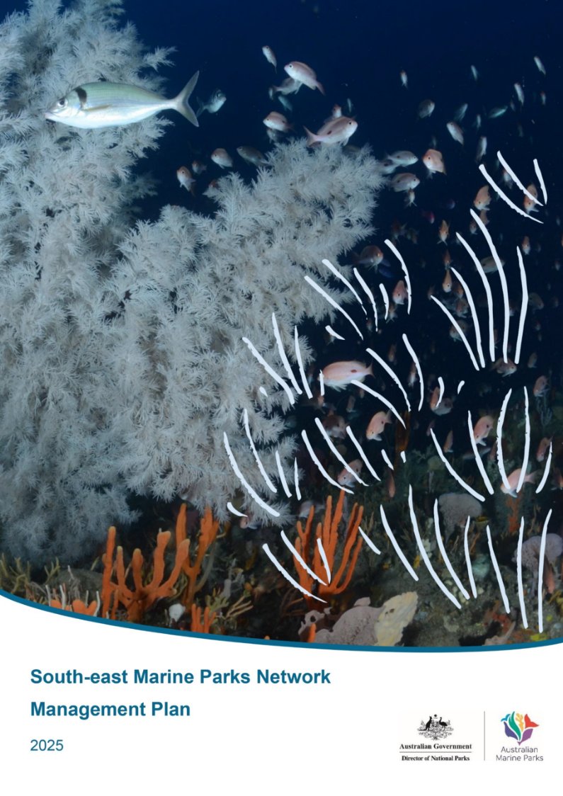
Front Cover – Large black coral, jackass morwong and school of butterfly perch at Joe’s Reef, Freycinet Marine Park (James Parkinson)
We acknowledge the Traditional Owners of the south-east region and their unbroken and continuing connection to land, sea, sky and community. We recognise that at least 17 different language groups continue to care for, manage, and maintain deep relationships with coastal land and seas in the region, safeguarding for Sea Country and keeping it healthy, since time immemorial.
Their knowledge, understanding and relationships to Sea Country are fundamental to the health and resilience of the South-east Marine Parks Network and the success of this management plan.
We pay our respects to them and their cultures and to their Elders both past and present.
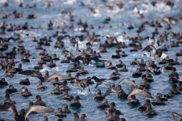
Image: Mutton bird – short-tailed shearwater (Wild Ocean Tasmania)
Contents
Acknowledgement of Country.................................................1
Foreword.................................................................5
A message from South-east Traditional Owners..................................7
1. Introduction...........................................................10
1.1 Introductory provisions................................................11
1.2 Management plan overview............................................12
1.3 Legislative context supporting Australian Marine Park management.............13
1.4 Australian Marine Parks...............................................13
1.5 Vision and objectives.................................................14
1.6 Changes from the previous management plan..............................14
1.7 Working in partnership with Traditional Owners.............................18
2. The South-east Marine Parks Network.....................................21
2.1 The south-east marine region..........................................22
2.2 The South-east Marine Parks Network....................................25
2.3 Values of the South-east Network.......................................29
2.3.1 Natural values........................................................29
2.3.2 First Nations values....................................................33
2.3.3 Other Protected Matters.................................................34
2.3.4 Social and economic benefits.............................................34
2.4 Pressures in the South-east Network.....................................35
2.4.1 Climate change.......................................................35
2.4.2 Extraction of living resources.............................................36
2.4.3 Physical disturbance...................................................36
2.4.4 Invasive species.......................................................36
2.4.5 Marine pollution.......................................................37
3. Approach to management...............................................38
3.1 Park management overview...........................................39
3.2 Ways of working....................................................40
3.3 Partnerships.......................................................40
3.4 Desired outcomes and management programs.............................41
3.5 Monitoring and evaluation.............................................44
4. Zoning and activity prescriptions.........................................45
4.1 Zone categories, names and objectives...................................46
4.2 Managing activities..................................................50
4.2.1 Environmental approvals and other applicable laws............................50
4.3 Prescriptions for activities.............................................51
4.3.1 General use, access and waste management................................53
4.3.2 Commercial fishing.....................................................57
4.3.3 Commercial aquaculture.................................................60
4.3.4 Commercial tourism (includes charter fishing tours)............................61
4.3.5 Commercial media.....................................................63
4.3.6 Recreational use (including fishing)........................................64
4.3.7 Offshore wind energy operations..........................................65
4.3.8 Mining operations (including exploration)....................................66
4.3.9 Offshore geological storage of carbon dioxide................................70
4.3.10 Space activities.......................................................71
4.3.11 Structures and works...................................................73
4.3.12 Research and monitoring................................................75
4.3.13 National security and emergency response..................................77
4.3.14 New activities and authorisations..........................................78
4.4 Making decisions about activities........................................78
4.4.1 Decision-making.......................................................78
4.4.2 Assessments under other processes.......................................79
4.4.3 Review of decisions....................................................79
4.5 Authorisation of activities..............................................81
4.5.1 Authorised activities....................................................81
4.5.2 Permits..............................................................81
4.5.3 Class approvals.......................................................82
4.5.4 Activity licences and leases..............................................84
4.5.5 Publication of authorisations..............................................85
Schedule 1: South-east Marine Parks overview..................................86
S1.1 South-east Network overview............................................87
S1.2 Key natural values of the South-east Network................................88
S1.3 Overview of marine parks of the South-east Network..........................92
East Gippsland Marine Park.................................................92
Beagle Marine Park.......................................................94
Flinders Marine Park.......................................................97
Freycinet Marine Park.....................................................100
Huon Marine Park........................................................103
South Tasman Rise Marine Park.............................................106
Tasman Fracture Marine Park...............................................108
Zeehan Marine Park......................................................111
Franklin Marine Park......................................................114
Boags Marine Park.......................................................117
Nelson Marine Park......................................................122
Murray Marine Park......................................................124
Macquarie Island Marine Park...............................................127
Schedule 2: Summary of legislative and policy contexts.........................130
S2.1 The EPBC Act and EPBC Regulations....................................131
S2.2 Other relevant legislation – Commonwealth................................134
S2.3 Other relevant legislation – state.........................................135
S2.4 International agreements..............................................135
Schedule 3: South-East Marine Parks Network zone boundary descriptions..........136
1. East Gippsland Marine Park..........................................137
2. Beagle Marine Park.................................................138
3. Flinders Marine Park................................................139
4. Freycinet Marine Park...............................................142
5. Huon Marine Park..................................................146
6. South Tasman Rise Marine Park.......................................148
7. Tasman Fracture Marine Park.........................................148
8. Zeehan Marine Park................................................152
9. Franklin Marine Park................................................155
10. Boags Marine Park.................................................156
11. Apollo Marine Park.................................................157
12. Nelson Marine Park.................................................158
13. Murray Marine Park.................................................158
14. Macquarie Island Marine Park.........................................163
Schedule 4: Supporting information..........................................167
S4.1 Supporting information................................................168
S4.2 Map data sources....................................................171
Glossary................................................................173
The establishment of the South-east Marine Parks Network (the South-east Network) in 2007 was a historic step for marine conservation, both in Australia and globally, creating the first
large-scale representative network of marine protected areas in the world.
For over 60,000 years before this, the Sea Country of the south-east marine region – of which the South-east Network is only a part – has been cared for and sustainably managed by Traditional Owners. Their traditional ecological knowledge and cultural environmental practices have been essential in maintaining the health of Sea Country over millennia. Through the preparation of this plan, Parks Australia has gained a deeper appreciation for the profound and enduring connection that Traditional Owners have to this Sea Country. Their stewardship remains vital to the preservation and management of these marine environments today and into the future.
The south-east region provides important foraging areas and migratory pathways for iconic, endangered and culturally significant species like blue and southern right whales and many species of albatross. The network of marine parks protects unique seafloor habitats, including deep-sea reefs, continental shelf habitats, seamounts canyons and kelp forests.
The region is the most intensely used in Australia and provides for a range of important social and economic activities, including commercial fishing, shipping, energy generation and recreational activities. These activities are core to the livelihoods of many local communities and provide benefits right across Australia.
This is the second management plan for the South-east Network and marks an important step in adaptive management of Australian Marine Parks as we apply lessons learned from more than a decade of management.
At the time of preparing this plan, the impacts of climate change are increasing globally. The south-east marine region is a global warming hotspot, where the rate of warming over the past 50 years is in the top 10% globally. The Australia state of environment 2021 report painted an alarming picture of the mounting pressures facing our marine environment, including from climate change, illegal, unregulated and unreported fishing, plastic and other pollution, offshore industries and marine noise. The 2021 report, along with the Independent Review of the Environment Protection and Biodiversity Conservation Act 1999 (Cth), highlight the need for fundamental reforms of our national environment laws, which are underway at the time of preparing this plan.
This plan introduces changes that increase protection within the network through zoning and rules for allowable uses, recognising the risks facing the south-east region over the coming decade. The plan seeks to build the resilience of park values by managing existing pressures and preventing new pressures. The changes in this plan build on momentum from 2023, when the Macquarie Island Marine Park in the Southern Ocean was expanded, increasing the size of the South-east Network from 388,464 km2 to 701,927 km2 (Figure 1.1).
This plan is the result of sustained consultation and engagement with governments, First Nations people, industry stakeholders, scientists and many other voices across Australia. I thank everyone who contributed to the development of this plan, including the many people who provided submissions through the statutory consultation processes. Your input has ensured we can find the right balance between strengthening protection and providing for sustainable use and enjoyment of our marine parks. I look forward to working in partnership with marine park users and communities to support the effective implementation of this plan.
Response to ‘Not without us, if it’s about us’
I extend my gratitude to the South-east Saltwater Council for their statement, ‘Not without us, if it’s about us’, included on pages 810 of this plan. The statement reflects the council’s views and aspirations, and understanding these ideals is an important first step toward meaningful collaboration with South-east Traditional Owners over time.
I recognise the importance of respecting Traditional Owners as partners, and not stakeholders, as highlighted in the statement. Traditional Owners bring unbroken, deep and longstanding connections, knowledge and values to the management of the South-east Network. Parks Australia is committed to strengthening collaboration with the South-east Traditional Owners as partners by engaging with the council and other culturally appropriate forums to implement this plan.
I would also like to thank the council for their candid feedback regarding engagement to date. Parks Australia is increasingly working to embed cultural competency as a core practice in the organisation. We will seek to engage early and meaningfully with Traditional Owners in managing our varied estate of parks, within the bounds of legal and regulatory frameworks.
I am a proud Djungan man and pleased to be the first Indigenous person to hold the position of Director of National Parks. I acknowledge that tensions may at times arise between the legal and institutional frameworks that define the regulatory office I hold and the aspirations of First Nations peoples to discharge their obligations to look after Country. I am committed to working transparently, in good faith and respectfully with the Traditional Owners of the South-east Marine Parks’ Sea Country to implement this plan.
Building genuine and respectful partnerships with Traditional Owners is fundamental to the success of this plan. By including commitments such as dual-naming initiatives, enhanced engagement and consultation processes, and the co-design of a Sea Country Strategy, I believe this plan lays the groundwork for developing, over time, a mutually beneficial partnership between Parks Australia and the South-east Traditional Owners, that can also support and benefit collaborations with marine parks users and the broader community.

Ricky Archer
Director of National Parks
Not without us, if it’s about us
Traditional Owners have never surrendered rights and authority to Country, including Sea Country. All Country was protected and cared for by our Ancestors for thousands and thousands of years and is cared for by our descendants today.
Before continuing with our message, we wish to pay respects to our Ancestors, men and women, for the strength, resilience, knowledge and wisdom they shared and applied to caring for Country and their communities. They knew, as we know today, that the health of Country is connected to the identity, health and wellbeing of our people. They knew that all Country – land, rivers, oceans and all living within it is interconnected and interdependent, and must be cared for in that way. Caring for Country also required, and continues today to include specific roles and responsibilities for men and women, alongside collective responsibility.
Our cultural and biocultural landscapes are unique. We are one of the oldest continuing cultures in the world, and our Country, all Country, is home to a vast array of plants, animals and places that have a cultural and practical value to us all. Today’s cultural landscapes reflect how we engage with our world and experience the surroundings. While colonisation resulted in our Land and Sea Country being broken up into artificial land and sea tenures and associated colonising management regimes, we remain connected to our Country, the cultural landscapes and our biocultural values that continue across these artificial boundaries today.
Country is a place of belonging, and way of believing and living, including culture, identity, spirituality, language, law, family, sustainable economy and trade.
Since dispossession and colonisation, Sea Country has been significantly and negatively impacted by a different world view and values. We are deeply saddened about the degradation that has happened as a result of dispossession and colonising approaches to the use and management of Sea Country.
Our voices, our values, and the knowledge passed down to us over many generations have been ignored to the detriment of Sea Country, and all people today.
We note that Marine Parks were created in Australia, including in the south-east marine region, in an attempt to conserve small pieces of our precious Sea Country. As a global warming hotspot in the top 10% globally we have no time to waste in working together as partners today to address degradation and to protect Sea Country for generations going forward.
Moving forward for the wellbeing of our Sea Country and people, we must take back control of our inherited rights and responsibilities to care for Country. We must be active leaders and respected partners in the fight to protect and preserve fragile marine and coastal Country for all. The time is now for our Saltwater Council, for Traditional Owners of the South-east Marine Parks, to unite and work together in the interests of our marine parks, connected oceans, coastlines, waterways and landscapes for generations that follow us.
We have expressed our sadness and frustration at the lack of inclusion of our voices, knowledge, values and interests in decision-making about Sea Country, including most recently the development of the South-east Marine Parks Network Management Plan (the Plan). We have expressed that we are unable to endorse the plan as we have had no part in its development.
We note that Parks Australia has acknowledged this fact, and has more recently worked with us to forge a far better way forward for all those who care about our Marine Parks and Sea Country. This will require the development of a genuine and long-term partnership with us over time, as opposed to being regarded as one of many groups or stakeholders; and tokenistic engagement.
Traditional Owners bring unbroken, deep and longstanding connections, knowledge and values to the management of Sea Country that will benefit all people, and most importantly Sea Country itself. We all need healthy Sea Country to survive and thrive, physically, culturally, spiritually and economically. All those who care for Sea Country understand this and it’s our belief and experience that management as partners will benefit all.
Our South-east, Saltwater Council alliance as Traditional Owners is unique. We are autonomous and self-determined in our rights, responsibilities and approaches to caring for Country, but we are connected for the shared purpose of vastly improving and protecting South-east Marine Parks and connected Sea Country.
To achieve this vision going forward, we must put Sea Country first, and our partners need to respect our view and assertion that:
If it’s about us, and all Country is about us, then planning, decision-making, and management must happen with us.
To be clear, with us means from the start of thinking about planning, to the end result of managing Country together, and how we keep track of the environmental, cultural, economic and other impacts of our decision-making and actions on Sea Country.
This requires a major shift in thinking about Traditional Owners as partners, and increased respect for our values, knowledge and assertions about how to best manage Sea Country; all aspects of Sea Country from cultural heritage through to environmental stewardship and management of recreational and commercial interests. Many of us are either working on, or have in place our own Sea Country Plans that guide our work with partners, and our own communities. These are highly valuable resources as we approach partnership work for South-east Marine Parks management.
We are committed to working as respected and respectful partners with government towards growing and sustaining our South-east Marine Parks, first established in 2007 – noting that our connection precedes that time by thousands and thousands of years. In working together, we need to acknowledge this fact that jurisdictional boundaries today can conflict with our ongoing connections to Sea Country – through millennia.
In this new era, we will work together, to improve the relationship with us, and the cultural competence of our partners and all those who care about Sea Country. We will work together to share our values, knowledge and assertions for Sea Country, and more specifically Marine Parks.
We will also work together to blend where appropriate our traditional ecological knowledge with new science and technologies. We will work collaboratively to co-design future management plans, and to build the next generation of First Nations Sea Country Guardians, planners, researchers and decision-makers.
We can do our best to remediate and address the significant damage and loss that is currently happening and that is rapidly increasing in our fragile marine and coastal environments, but we need to do this now and together.
Climate change and other anthropogenic pressures on our Sea Country do not wait. The time to act together is now.
This statement is endorsed by the following members of the South-east Saltwater Council:
The South-east Marine Park Saltwater Council is a newly established Council whose membership includes Registered Aboriginal Parties (RAP) from Victoria, South Australia, and Tasmania. It is expected that membership to this Council will continue to grow over time.
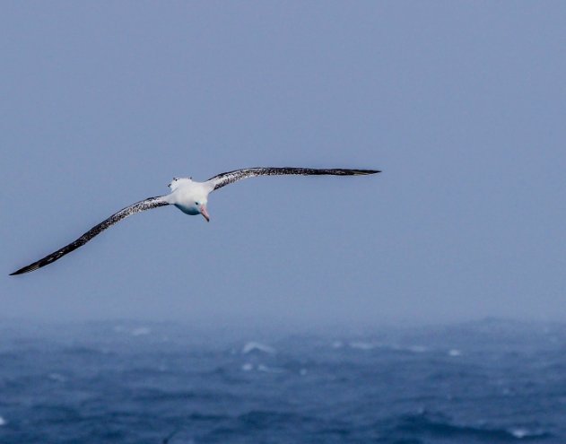
Image: Wandering albatross (Kim Kliska/Australian Antarctic Division)
Name
This plan is the Environment Protection and Biodiversity Conservation (South-east Marine
Parks Network Management Plan) Instrument 2025.
Commencement
This instrument commences on the day after it is registered on the Federal Register of Legislation.
Interpretation
The Glossary provides the meaning of certain words, acronyms and expressions used and includes references to certain words and expressions that are defined in the Environment Protection and Biodiversity Conservation Act 1999 (Cth) (EPBC Act).
Authority
This instrument is made by the Minister under sections 370(3) and 371(1) of the EPBC Act.
This plan replaces the previous South-east Commonwealth Marine Reserves Network Management Plan 20132023.
This plan is structured into 4 chapters and 4 schedules, outlined below in Table 1.1.
Table 1.1 Structure of this plan
Management plan and supporting information | |
Chapter 1 Introduction | Outlines the context and approach to managing Australian Marine Parks. |
Chapter 2 The South-east Marine Parks Network | Outlines the values and pressures of the South-east Marine Parks Network. |
Chapter 3 Management approach | Provides an overview of marine park management and describes the desired outcomes, management programs, goals and actions for the South-east Marine Parks Network. |
Chapter 4 Zones and rules of the network | Provides details for the management of the South-east Marine Parks Network, including zoning design and prescriptions for managing activities. |
Schedule 1 South-east Marine Parks Network overview | Provides a summary for each marine park, including a description of values, social and economic benefits, other protected place arrangements and a zoning map with coordinates. |
Schedule 2 Summary of legislative and policy contexts | Includes a summary of relevant legislation, including the Environment Protection and Biodiversity Conservation Act 1999 (Cth) (EPBC Act) and Environment Protection and Biodiversity Conservation Regulations 2000, other relevant state and Commonwealth legislation and international agreements. |
Schedule 3 Coordinate descriptions | Gives coordinate descriptions for the zones within each marine park. |
Schedule 4 Supporting information | Lists references used in preparing this plan. |
Glossary | Lists terms and words used in this plan, including references to certain words that are defined in the EPBC Act. |
At the time of making this plan, the EPBC Act is Australia’s primary environmental legislation. Under the EPBC Act, the Governor-General may declare an area of sea in a Commonwealth marine area as a Commonwealth reserve. For the purposes of this plan, these Commonwealth reserves are referred to as Australian Marine Parks.
The Director of National Parks (the Director) has primary responsibility for the administration, protection, conservation and management of Australian Marine Parks.
Under the EPBC Act, the Director is required to make management plans for the protection and conservation of marine parks and must manage the marine parks consistently with the relevant management plan. Additionally, the Director may make a single management plan for the management of more than one marine park.
The marine parks in the South-east Marine Parks Network (South-east Network) were established between 1999 and 2007 (see Schedule 1 for full details). The first management plan for the South-east Network came into effect in 2013 and expired in 2023.
Sections 354 and 354A of the EPBC Act and Division 12 of the Environment Protection and Biodiversity Conservation Regulations 2000 (EPBC Regulations) set out offence provisions which prohibit certain actions from being taken in marine parks unless the action is taken in accordance with a management plan for that marine park. This plan sets out what actions may be undertaken in the South-east Network, and the conditions under which they may be undertaken. This plan also complements, and is in addition to, a range of other Commonwealth, state and territory laws, as well as international conventions and agreements that relate to protection of the marine environment (Schedule 2).
Other Commonwealth, state and territory government agencies also have statutory roles in managing fisheries, tourism, petroleum activities, renewable energy operations, other offshore industries, shipping, maritime pollution and biosecurity threats. This plan does not purport to provide approval or authorise actions and applications under other Commonwealth, state and territory laws.
Australian Marine Parks are areas of ocean within Commonwealth marine areas, which start at the outer edge of state and territory waters, generally 3 nm (approximately 5.5 km) from the shore, and extend to the outer boundary of Australia’s Exclusive Economic Zone, 200 nm (approximately 370 km) from the shore. Australian Marine Parks are specifically designated and managed to protect the marine environment while also providing opportunities for sustainable commercial and recreational use. Australian Marine Parks play an important role in:
- protecting and conserving representative examples of marine biodiversity and associated ecosystems, including areas associated with unique or rare geological features
- protecting critical sites for reproduction and growth of species
- increasing the resilience of marine ecosystems against pressures such as pollution, climate change, overuse of resources and marine pests
- protecting important tangible and intangible First Nations values, such as areas now under sea that were part of the landscape used by First Nations people during the late Pleistocene (the last ice age)
- regulating human use to ensure activities are undertaken in an ecologically
sustainable manner.
Over 2 decades ago, all governments in Australia committed to a National Representative System of Marine Protected Areas (NRSMPA). The primary goal of the NRSMPA is to establish and manage a comprehensive, adequate and representative system of marine protected areas. Broadly, this means ensuring the system of marine parks includes all of Australia’s marine bioregions and that the range of different ecosystems and biological features within these bioregions are adequately represented in marine parks to ensure their long-term viability.
At the time of making this plan, the Australian Government’s contribution to the NRSMPA includes 60 Australian Marine Parks, managed by the Commonwealth Director of National Parks (supported by Parks Australia); the Great Barrier Reef Marine Park, managed by the Great Barrier Reef Marine Park Authority; and the Heard Island and McDonald Islands Marine Reserve, managed by the Australian Antarctic Division of the Department of Climate Change, Energy, the Environment and Water. Marine parks have also been established by state and territory governments in their respective waters under the NRSMPA.
The 60 Australian Marine Parks are spread across 5 networks (South-east, South-west, North-west, North and Temperate East), the Coral Sea and the Indian Ocean Territories. At the time of making this plan, they collectively cover 3.8 million km2, or 43%, of Australian waters.
Management of Australian Marine Parks requires a balance between protection of our marine environment and opportunities for sustainable use and enjoyment of these special places.
The vision of the Director of National Parks is that the South-east Marine Parks Network is healthy and resilient for current and future generations. |
The objectives of the South-east Network are to provide for:
- the protection and conservation of biodiversity and other natural and cultural values of marine parks in the South-east Network
- ecologically sustainable use and enjoyment of the natural resources within marine parks in the South-east Network, where this is consistent with the objective above.
These objectives are broadly applied across all Australian Marine Parks. A set of more specific desired outcomes have been identified in Chapter 3 of this plan for the South-east Network.
This is the second management plan for the South-east Network and builds on significant advances in the scientific knowledge about the region’s ecosystems; lessons learned from managing the marine parks since 2007; findings from the independent evaluation of the 20132023 management plan; and comments received through statutory public consultation processes. This plan also encapsulates the expanded Macquarie Island Marine Park, which came into effect on 1 July 2023.
This plan seeks to improve both the network design and its management through changes to zoning, allowable activities and management programs, compared with the previous management plan (in place from 2013 to 2023). In line with the marine park objectives, these changes are intended to find the right balance between protection of marine park values and sustainable use.
Zoning design
Zoning is the basis for marine park management, providing for various activities to be undertaken in different areas. This plan has changed existing zones in the network, while also creating new zones and changing the shape of some zones. This includes:
- 5 marine parks with new offshore National Park Zones (International Union for the Conservation of Nature, IUCN II) that were previously categorised as Special Purpose Zones (IUCN VI) under the last management plan. This change formalises a long history of almost no extractive use in these areas, including at South Tasman Rise, Tasman Fracture, Murray, Nelson and Zeehan Marine Parks
- 7 parks with new National Park Zones (IUCN II). These zoning upgrades were carefully selected to protect important values in shelf, slope, canyon and seamount environments, that were subject to multiple pressures, while minimising impacts on existing users where possible. These changes were made to Beagle, Flinders, Freycinet, Franklin, Huon, Tasman Fracture and Murray Marine Parks
- 2 parks with new areas for pelagic fishing access. Recognising the significant spatial squeeze experienced by the sector in the south-east marine region, the shifting ranges of target species in response to climate change, and the ongoing improvements to the sustainability of these fisheries, these changes were made to Flinders (IUCN IV pelagic fishing only) and Murray (IUCN IV pelagic fishing only) Marine Parks:
- Flinders: the new Habitat Protection Zone is below the 4,000 m depth contour and entirely over the abyss – an ecosystem type that is extensively represented in highly protected zones in the network and in this marine park.
- Murray: the new Habitat Protection Zone is carefully placed to continue to protect benthic habitats, while opening access to sustainable commercial fishing activities that are excluded from the canyons by the new highly protected zones in the park.
Collectively, zoning changes in this management plan represent an improvement on the previous plan zoning, when considering the design principles of comprehensive, adequate and representative protection, in the Guidelines for establishing the National Representative System of Marine Protected Areas (ANZECC, 1998).
Allowable activities
This plan establishes tighter rules for and prohibitions of some industrial activities, with the premise that these activities should happen outside of marine parks where possible. The
plan considers new and emerging activities that were not contemplated by the previous management plan.
Management programs
This plan has simplified the 7 strategies from the previous management plan to a smaller set of
4 focused programs to better provide for national consistency, while allowing a flexible approach. It includes more targeted actions and a set of specific desired outcomes to guide monitoring and evaluation of this plan and to inform continual improvement.

Image: A school of jackass morwong in Freycinet Marine Park
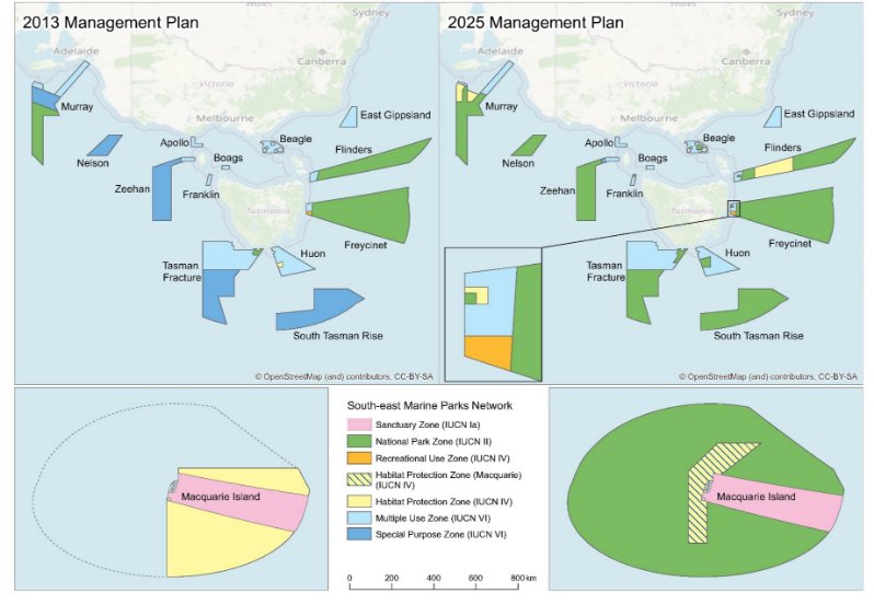
Figure 1.1 Map showing zoning changes from the 2013 to the 2025 plan.
Note: Macquarie Island Marine Park was expanded in 2023.
This management plan respects and upholds First Nations people’s responsibilities as both holders of knowledge and managers of Sea Country. The Director recognises Traditional Owners have interests in all aspects of marine park management. Strong, respectful and genuine partnerships with First Nations people are fundamental to managing the full suite of values in the South-east Network. The Director and Parks Australia staff are committed to working with First Nations people to protect these values, as well as to maximise opportunities for the enjoyment, management and use of their Sea Country within marine parks.
National recognition
In implementing this plan, the Director acknowledges the rights and cultural interests of First Nations people and the deep understanding and experience that First Nations people can contribute to the management of Australian Marine Parks. The Director also has an obligation to maximise contributions to Closing the Gap and deliver on the Closing the Gap Targets and Priority Reforms. The rights and interests of First Nations people are also recognised in the EPBC Act and the Native Title Act 1993 (Cth).
Indigenous Cultural and Intellectual Property
First Nations people are the primary source of information on the value of their cultural heritage. For this reason, the active participation of First Nations people will be sought in the identification and management of First Nations values in marine parks through the development of values statements. The Director is committed to respecting the cultural authority of First Nations people for their values and will seek the free, prior and informed consent of First Nations people before recording, storing or sharing information on First Nations values. The Director will seek to implement best-practice approaches for managing Indigenous Cultural and Intellectual Property (ICIP). This includes adhering to the principles of Indigenous Data Sovereignty and using data sharing agreements, as appropriate.
Engagement through the South-east Saltwater Council
Alliance-based approaches can effectively strengthen First Nations voices, relationships, collective actions and solutions, and their collaborative investment in Sea Country. A key mechanism for engaging with First Nations will be through alliances, particularly the newly established South-east Saltwater Council. Parks Australia will work with Traditional Owners to explore and support this model, and any discrete partnerships that may arise.
The South-east Saltwater Council brings together Traditional Owners from coastal Victoria, Tasmania and South Australia. Initiated by Traditional Owners of the region, the council serves as a First Nations-led forum prioritising healthy Sea Country and governance for the collective good by providing a safe space for discussion and agreement-making.
Engagement through the South-east Saltwater Council does not preclude other partnership mechanisms identified over the life of this plan, in the interests of culturally safe and appropriate management. The Director will also engage with individual relevant Native Title representative bodies and Aboriginal Community Controlled organisations as needed.
Principles for working in partnership with First Nations people
Parks Australia acknowledges Traditional Owners as essential partners in the management of Sea Country within Australian Marine Parks, and recognise their historical exclusion from managing country
The following partnership principles were developed with guidance from the South-east Saltwater Council. They are based on engagement principles first published in 2018, following collaboration between the Director and representatives from land councils, Native Title representative bodies, and Indigenous ranger groups.
The principles published here are preliminary working principles intended to guide how Parks Australia and the South-east Traditional Owners work together. These principles are intended to be further refined through the co-design of a Sea Country Strategy for the South-east Network. The most up-to-date version of the principles will be made available online. This approach provides opportunities for review in collaboration with Traditional Owners, ensuring the principles evolve over time as we continue to learn and strengthen our working relationship.
Table 1.2 – First Nations partnership principles
Principle 1: It is recognised that First Nations people have been sustainably using and managing their Sea Country, including areas now included within Australian Marine Parks, for many thousands of years – in some cases since before rising sea levels created these marine environments and across ice-ages. Principle 2: Management of Australian Marine Parks should be undertaken on the basis that Native Title exists in Sea Country within Commonwealth waters. Principle 3: First Nations people will be positioned and supported as partners in planning and managing Australian Marine Parks on the basis of their nationally and internationally recognised rights and cultural interests. Principle 4: Maximise opportunities for First Nations people to engage in self-determined cultural practices, and to enjoy the use of their Sea Country and actively participate in its management. Principle 5: Maximise opportunities for the development of self-determined First Nations livelihoods, consistent with national Closing the Gap commitments, and First Nations rights and interests in building ethical, sustainable and community benefiting commercial enterprises and maximise local employment opportunities. Principle 6: Governance and management activities within Australian Marine Parks respect and support local First Nations self-determination and governance frameworks. These activities aim to avoid duplicating existing governance mechanisms, uphold respect for local arrangements, and provide resources to enable meaningful participation in governance to inform decision-making. Principle 7: First Nations engagement in managing Australian Marine Parks is undertaken through good faith negotiations, seeking to build on the common ground that exists between First Nations peoples and the Australian Government to protect and sustainably use Australia’s Sea Country environments and resources. Principle 8: Third-party investment in management activities in Australian Marine Parks for example, through environmental offset investments prioritise support for First Nations people’s interests, capacity-building and development of livelihoods, consistent with all other principles outlined above; such third-party investments must not impact on Native Title negotiations or the rights to compensation. Principle 9: Sustainable commercial activities on Sea Country provide economic and environmental benefits to Traditional Owners, the broader community, and Sea Country itself. Where appropriate, international best practice models for community asset benefit sharing will be applied. |
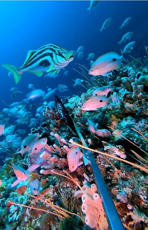
Image: Striped trumpeter and butterfly perch in Tasman Fracture Marine Park (Institute for Marine and Antarctic Studies)
The south-east marine region extends from southern New South Wales, around Tasmania to Kangaroo Island in South Australia and includes the waters of Bass Strait and those surrounding sub-Antarctic Macquarie Island (Figure 2.1). The region covers approximately 1.63 million km² of temperate and sub-polar waters and extends from state waters to the limit of the Australian Exclusive Economic Zone.
First Nations people are rights holders and caretakers of Sea Country. They have managed and cared for Sea Country within the south-east marine region for tens of thousands of years and kept it healthy. Coastal areas of south-east Australia were amongst the most densely populated regions of pre-colonial Australia. At least 17 distinct First Nations language groups owned, occupied and used coastal land and seas in the region. Vast areas of the region were once dry land that connected mainland Australia to Tasmania, and this land was traversed and lived on for thousands of years. These ancestral landscapes form part of the cultural landscapes important to First Nations people today. First Nations people continue to use and manage the coastal and marine environments of the region as a resource and to maintain cultural identity, health
and wellbeing.
The south-east marine region is the most intensely used marine region in Australia. Human activities in the region include commercial fishing, oil and gas production, shipping, tourism, recreational fishing and boating, scientific research, and emerging activities such as offshore windfarms, carbon management technologies, offshore aquaculture and space rocket launches. The marine environment supports regional economic growth, employment and social wellbeing.
The south-east marine region provides a substantial component of Australia’s domestic and exported seafood via fisheries such as the Southern and Eastern Scalefish and Shark Fishery and rock lobster and tuna fisheries. At the time of making this plan, the Australian and Tasmanian governments are also working together to facilitate trials for offshore aquaculture
in the region.
The south-east marine region plays an important role in Australia’s energy production. The Bass Strait is a major supplier of gas for Australian east coast domestic users, and ongoing gas supply has been identified as crucial to Australia’s transition to Net Zero emissions by 2050.
At the time of making this plan, the Australian Government is in the process of declaring areas as being suitable for offshore renewable energy infrastructure, including offshore wind. Three of Australia’s 6 areas are within the broader Bass Strait area, which has been identified as a prime location for offshore windfarms due to its strong and consistent winds and its proximity to areas of high electricity demand.
The region is a global marine warming hotspot an area where the rate of warming over the past 50 years is in the top 10% globally. Pressures in the region are expected to increase during the life of this plan, including due to climate change (Section 2.4).
The south-east marine region includes ecosystems spanning depths from the continental shelf to the slope and down to the abyssal plain (deep ocean floor). The continental shelf, including Bass Strait, is a mosaic of rocky reefs and soft sediments. Marine canyons, which deeply incise the continental slope, are a common feature of the region and include the Sprigg Canyon one of Australia’s largest and most spectacular marine canyons. Globally significant clusters of seamounts (underwater volcanoes) occur south and east of Tasmania. The seamounts rise 4,000 m above the seafloor, with the shallowest peaks reaching about 750 m below the sea surface. Several ocean currents influence the region and its climate. The eastern parts of the region are strongly influenced by the East Australian Current, which carries warmer, nutrient-poor waters and tropical and subtropical marine species southward. Over the last 50 years the East Australian Current has strengthened and extended about 350 km further south. The western parts of the region are influenced by the warmer south-easterly/southward-flowing Leeuwin and Zeehan currents. Macquarie Island lies in the path of the Antarctic Circumpolar Current. In winter the Antarctic Circumpolar Current moves north and passes close to Tasmania, bringing colder, nutrient-rich water to the area.
The region is relatively low in nutrients and primary productivity; however, in some locations, water bodies converge, mix and rise close to the surface to create areas of enhanced primary productivity, which support aggregations of pelagic marine life. Examples include the Bonney Upwelling and the upwelling east of Eden.
Owing to the complex geomorphology, ocean current systems and evolutionary history of the area, the marine environment contains high biodiversity, including many species endemic to southern or south-eastern Australia. The region also includes Biologically Important Areas for many species protected under the EPBC Act, including seabirds, whales and sharks.
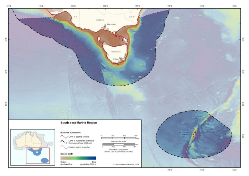
Figure 2.1 South-east marine region
The South-east Marine Parks Network (South-east Network) (Figure 2.2) covers 701,927 km2 and includes 14 marine parks. It was designed to protect representative examples of the region’s ecosystems and biodiversity in accordance with the Goals and principles for the establishment of the National Representative System of Marine Protected Areas (ANZECC, 1998).
Australia’s marine environment has been divided into bioregions large areas of ocean with broadly similar characteristics based on the distribution of marine species, seafloor features and ocean conditions (Integrated Marine and Coastal Regionalisation of Australia (IMCRA)). All 10 provincial bioregions in the region are represented in the South-east Network, along with 10 of the 11 mesoscale bioregions (Figures 2.3 and 2.4).
The South-east Network comprises the following 14 marine parks (presented in a clockwise geographical order starting off at the coast of southern New South Wales, moving around Tasmania up to Cape Otway and across to South Australia, then to the sub-Antarctic):
- East Gippsland Marine Park
- Beagle Marine Park
- Flinders Marine Park
- Freycinet Marine Park
- Huon Marine Park
- South Tasman Rise Marine Park
- Tasman Fracture Marine Park
- Zeehan Marine Park
- Franklin Marine Park
- Boags Marine Park
- Apollo Marine Park
- Nelson Marine Park
- Murray Marine Park
- Macquarie Island Marine Park.

Figure 2.2 South-east Network

Figure 2.3 Provincial bioregions of the south-east marine region

Figure 2.4 Mesoscale bioregions of the south-east marine region
Australian Marine Park ‘values’ are those features within a park that provide focus for protection and park management. Values of the South-east Network are described in different categories below, noting there is often overlap between these categories:
- Natural values – species and the genetic diversity they contain, habitats, ecological communities, ecosystems and geological and geomorphological features within marine parks and the processes that sustain them
- First Nations values – values and features identified by Traditional Owners as important to protect, including, but not limited to, tangible and intangible aspects of culture, knowledge, objects, and natural values, biodiversity and ecosystems
- Other Protected Matters – those matters afforded protection status under other legislation, such as the Underwater Cultural Heritage Act 2018 (Cth), and that occur within the marine parks.
Through effective design and management, the South-east Network can enhance social and economic benefits for people, businesses and the economy, provided by the values within marine parks.
An overview and a summary of values for each park in the South-east Network are set out in Schedule 1. Detailed values information for each park is provided on the Parks Australia website and is updated over time as new information becomes available.
There are a range of ways in which we group and define values to inform management within
the South-east Network. These include but are not limited to:
- Ecosystems – a dynamic complex of plant, animal and microorganism communities
and their non-living environment, interacting as a functional unit. Figure 2.5
illustrates, and Table 2.1 summarises, the different ecosystem types found
within the South-east Network - Key ecological features – elements of the marine environment that are considered to be important for biodiversity or ecosystem function and integrity. Five of the 8 key ecological features of the south-east region occur in the South-east Network, including seamounts east and south of Tasmania; shelf rocky reefs and hard substrate; west Tasmania canyons; upwelling east of Eden; and the east Tasmania subtropical convergence zone
- Biologically important areas – places where aggregations of individuals of a protected species breed, forage or rest during migration. In the South-east Network there are biologically important areas for 14 seabird species, 3 whale species, Australian sea lions and the white shark
- Key natural values – habitats or species that are particularly important from a park management perspective due to their uniqueness, functional importance, vulnerability to pressures, biological productivity, diversity or ability to provide social and economic benefits. Key natural values criteria may be updated throughout the life of this plan and new values recorded as understanding of the parks continues to improve. At the time this plan was made, 13 key natural values have been described (Table S1.2 in Schedule 1).
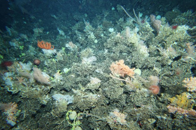
Image: Deep-sea coral community in Huon Marine Park
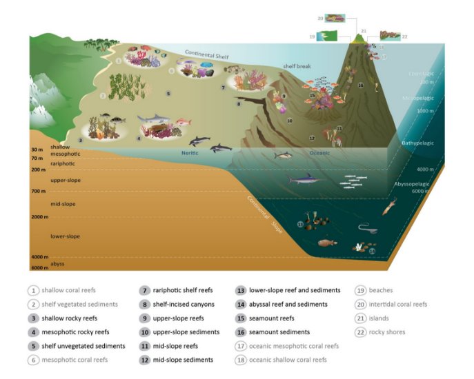
Figure 2.5 Representation of the different ecosystem types present in Australian Marine Parks. Ecosystems in black text are present in the South-east Network. Those in light grey text do not occur in the South-east Network.
Table 2.1 Description of ecosystems present in the South-east Network
Ecosystem | Description |
Mesophotic rocky reefs | Middle-light rocky reefs where there is still sufficient light for photosynthesis to occur. Typically found in depths of 30 m to 70 m. Recorded in Apollo, Beagle, Flinders, Freycinet, Huon, and Franklin Marine Parks. |
Rariphotic shelf reefs | Rare-light rocky reefs where there is insufficient light to support photosynthesis. Typically found in depths of 70 m to 200 m. Recorded in Flinders, Freycinet, Huon, Tasman Fracture and Zeehan Marine Parks. |
Shelf unvegetated sediments | Sediment habitats on the continental shelf (0 m to 200 m depth) that lack marine macroalgae or seagrass. Present in all marine parks on the continental shelf. |
Upper-slope reefs | Reef habitats on the upper section of the continental slope between shelf break (nominally 200 m depth) and 700 m depth. Recorded in Flinders and Zeehan Marine Parks. |
Upper-slope sediments | Sediment habitats on the upper continental slope (200 m to 700 m depth). Present in East Gippsland, Flinders, Freycinet, Huon, Tasman Fracture, Zeehan and Murray Marine Parks. |
Canyons | Steep-sided valleys in the seabed. Shelf-incised canyons extend onto the continental shelf at least 500 m shoreward of the shelf break. Recorded in Flinders, Zeehan and Murray Marine Parks. |
Mid-slope reefs | Reef habitats on the mid-continental slope between 700 m and 2,000 m depth. Recorded in Huon Marine Park. |
Mid-slope sediments | Sediment habitats on the mid-continental slope (700 m2,000 m depth). Present in East Gippsland, Flinders, Freycinet, South Tasman Rise, Huon, Tasman Fracture, Zeehan and Murray Marine Parks. |
Lower-slope reef and sediments | Reef and sediment habitats on the lower continental slope and continental rise, between 2,000 m and 4,000 m depth. Present in East Gippsland, Flinders, Freycinet, South Tasman Rise, Huon, Tasman Fracture, Zeehan, Nelson and Murray Marine Parks. |
Abyssal reef and sediments | Reef and sediment habitats in the abyssal zone, between 4,000 m and 6,000 m depth. Present in East Gippsland, Flinders, Freycinet, South Tasman Rise, Tasman Fracture, Zeehan, Nelson and Murray Marine Parks. |
Seamount reefs | Rocky and deep-sea cold-water coral formations occurring on seamounts. Recorded in Huon and Tasman Fracture Marine Parks. |
Seamount sediments | Sediment habitats occurring on seamounts. Present in Freycinet, Huon, Tasman Fracture and South Tasman Rise Marine Parks. |
Traditional Owner articulation of values
The South-east Saltwater Council provides the following articulation of values:
Traditional Owners cultural and other values specifically acknowledge the deep and unbroken connection between our people and Sea Country, as an intrinsic part of our identity past, present and future. Our values include respect and responsibility for the health and wellbeing of Country and people. Country is viewed as interconnected and interdependent, with artificial or imposed colonial boundaries, and siloed approaches to management being opposite and often detrimental to our values, cultural practices, beliefs and knowledge about sustainable uses.
Our cultural values and knowledge systems passed down through generations include creation stories; discrete men’s and women’s cultural practices and obligations to care for Country; knowledge about how to care for Sea Country and conduct of cultural and other practices; knowledge about places and objects such as sites to be protected, species, biodiversity and ecosystem priorities, conservation and protection.
First Nations Values will be identified collaboratively with Traditional Owners over the implementation of this management plan through the development of values statements to inform management. This process will use methods that respect and uphold the cultural authority, integrity and role of Traditional Owners as knowledge holders and managers of Sea Country.
Examples of First Nations values identified in this plan include:
- Ancient land bridge – Areas that are now under the sea in the South-east Network were part of the landscape used by First Nations people during the late Pleistocene (ice age), before sea levels stabilised at current levels about 7,000 years ago. This large area of submerged paleo-landscape connected Lutruwita (Tasmania) to the mainland and was lived on for thousands of years before it was submerged. The flooding of this Country is also a form of oral tradition, detailed in stories that have been passed down through thousands of generations. Several marine parks overlap with this submerged
paleo-landscape, including Beagle, Flinders and Apollo Marine Parks. - Culturally significant species – Many areas of the South-east Network are important for culturally significant species. Mutton birds, seals and whales are wide-ranging animals that feed in and migrate through many parks in the network. First Nations people have a cultural obligation to care for these and other marine animal resources. Coastal marine environments and offshore marine environments are also interconnected, and the marine parks in the South-east Network have an important role in supporting inshore marine resources.
- Songlines and stories – First Nations people continue to honour ancient saltwater songlines, migrations, stories and ancestral connections that intersect with areas of the South-east Network. This knowledge is sacred and has been passed from generation to generation.
- Sea Country IPAs At the time of making this plan the consultation Tayaritja Milaythina Muka Indigenous Protected Area (IPA) overlaps Flinders Marine Park. This is the first Sea Country IPA consultation project in the South-east Network. It extends from north-east Lutruwita/Tasmania over the submerged land bridge and surrounds Tayaritja/Bass Strait Islands. The aim of the Tayaritja Milaythina Muka IPA consultation project is to protect culturally and ecologically important habitats and species.
A number of matters that are protected by specific legislation occur within marine parks and are also afforded protection under this management plan:
- World Heritage Parts of Macquarie Island Marine Park, from the inshore boundary out to about 16.7 km (the edge of the territorial seas) intersect with the Macquarie Island World Heritage Area, which was listed for its outstanding geological values and wild natural beauty, including large aggregations king penguins, elephant seals and royal penguins – a species endemic to Macquarie Island and the nearby Bishop and Clerk Islets. This area is also on the National Heritage List.
- National and Commonwealth Heritage The Tasmanian Seamounts Commonwealth Heritage Area lies within the Huon Marine Park. The seamounts were listed because they support a deep-sea benthic community characterised by high biodiversity and endemism and long-lived, slow-growing species vulnerable to disturbance.
- Underwater cultural heritage, including historic shipwrecks Shipwrecks, sunken aircrafts and other kinds of underwater artefacts can be protected for their cultural heritage significance under the Underwater Cultural Heritage Act 2018.
The values in the South-east Network, when effectively protected, support a range of ecosystem services and provide important social and economic benefits. These social and economic benefits underpin the prosperity and wellbeing of First Nations people and regional communities and contribute to our national economy and prosperity:
- Benefits for Australians – Many Australians derive social benefits from knowing that the marine environment exists in a certain state and is managed effectively (existence value), it is protected for future generations (bequest value), and there is the opportunity to use a particular location in the future for commercial or recreational purposes (option value).
- Commercial fishing – Several valuable and important fisheries operate in the
South-east Network. These include the Eastern Tuna and Billfish Fishery, the Southern Bluefin Tuna Fishery, the Southern and Eastern Scalefish and Shark Fishery, the Macquarie Island Toothfish Fishery and a range of state-managed fisheries, including octopus, rock lobster, giant crab, scalefish and sardine fisheries. Commercial fishing is an important contributor to regional and local economies, with local ocean produce a drawcard for food tourism in the south-east. Rock lobster and tuna are also major contributors to Australia’s seafood exports. - Commercial shipping – Shipping routes supporting effective trade and commerce in southern Australia transit through the marine parks, consistent with zoning rules.
- Marine tourism – Marine tourism activities such as charter fishing and wildlife watching can provide unique visitor experiences in offshore marine parks that are often difficult for recreational users to visit. At the time this plan was developed, there was one licensed marine tourism operator in the South-east Network, operating in Beagle Marine Park.
- Offshore mining operations – Exploration and extraction of oil and gas deposits in the south-east marine region contribute to Australia’s transition to Net Zero emissions by 2050. Existing petroleum titles in the network remain accessible to mining operations, but all other areas of the network have been closed to mining.
- Recreational use – Due to the remoteness of many of the parks, recreational use is generally lower compared with near-shore areas, although it may increase during the life of this plan as bigger vessels become more available and more users can travel further offshore. Certain parks, such as Freycinet Marine Park, provide important recreational opportunities for the recreational boating, deep diving and fishing community.
- Scientific use – The South-east Network supports scientific research and monitoring through allowing access to protected areas and providing important scientific reference areas to better understand differences between protected and exploited areas to inform management of the broader marine environment. Under the previous plan, there were on average 8 active authorisations for science activities annually.
- Sea Country connections – The network provides for traditional uses to continue across all zoning, and management provides opportunities for First Nations people to visit and connect with Sea Country that intersects the marine parks.
Pressures are human-driven processes, events and activities that may impact negatively on marine park values. The pressures on marine park values of the South-east Network are strongly influenced by human activities occurring within the south-east marine region the most intensely used marine region in Australia.
The pressures in the region are expected to result in increased pressures on the South-east Network over the life of this plan. The range of new and emerging uses are expected to add to the cumulative impacts on marine park values. For example, emerging industries may influence species distributions directly and indirectly through the displacement of other activities into the parks. Climate change is also driving significant ecological change across the south-east marine region and network, including, for example, climate-driven changes in the distribution of species.
Key pressures on values in the South-east Network are outlined below and additional information on pressures is provided on the Parks Australia website.
The impacts of climate change on the marine environment are complex and may include longer lasting marine heatwaves, continued rise in sea level, further ocean acidification, changes to ocean currents and eddies, increased storm frequency, and species range extensions or local extinctions. These multifaceted changes have the potential to significantly impact on marine park values. Moreover, climate changes will interact with and amplify other non-climate pressures affecting marine park values.
The marine environments of south-eastern Australia are a global marine warming hotspot regions where the rate of warming over the past 50 years is in the top 10% globally. The warm, nutrient-poor waters of the East Australian Current extend along the east coast of Tasmania about 350 km further south than in the 1950s. The region has been, and is predicted to continue to be, affected by severe marine heatwaves, with sea surface temperatures greater than 2 degrees above average levels over several months.
This ocean warming is resulting in ‘tropicalisation’ of species (the appearance of species typically found further north) and cool-water species moving further south. The first recorded observations were in about the 1950s, with the arrival of the long-spined sea urchin in the Kent Group of Bass Strait islands, but over time increasing numbers of warmer water species are being observed. The east coast of Tasmania is also experiencing significant declines in the abundance of kelp, particularly cool-water adapted species. It is likely the result of both warmer and more nutrient‑poor waters.
Bleaching of sponges on mesophotic reefs was observed in Flinders Marine Park in 2017 likely associated with a significant marine heatwave in the summer of 2015–2016. It is one of the early reports of bleaching in temperate sponges.
Commonwealth and state government fisheries management agencies are responsible for management of commercial and recreational fishing in the South-east Network, including ensuring sustainable fishing practices. This includes undertaking detailed risk assessments and putting in place a range of measures to reduce bycatch and other impacts on the marine environment. Fishing, including illegal, unregulated and unreported fishing, can modify natural populations of target species. Bycatch of non-target species and/or physical disturbance to habitats can result from certain fishing methods and may therefore impact on marine park values.
Illegal fishing by foreign fishing vessels in remote offshore green National Park Zones that
extend to the boundary of Australia’s Exclusive Economic Zone, such as Macquarie Island Marine Park and South Tasman Rise Marine Park, is a risk to values in these parks. Partnerships with other government agencies with sea and air patrol capability support Parks Australia to manage this risk.
Habitats in marine parks can be impacted through physical disturbance such as anchoring, fishing activities or installation of infrastructure for example, telecommunications or power generation submarine cables. Physical disturbance can directly damage or remove habitat or indirectly affect benthic flora and fauna through suspended sediments causing localised smothering and or reducing the quality and quantity of light received at the seabed.
Wildlife can be impacted by human presence through either direct impacts, such as vessels colliding with wildlife (known as vessel strike), or indirect impacts, such as changes to the natural behaviour of wildlife such as breeding, feeding or resting.
Invasive species can be pathogens that cause disease, exotic marine pests or overabundant native species.
Potential sources of invasive species include climate-driven range changes, vessel ballast and bilge water discharge, vessel biofouling and accidental or deliberate transport of species. Shallower water ecosystems and native species are particularly vulnerable to invasive species. They can impact these values directly, through disease, predation or damaging important habitats; and indirectly, through competition with native species for habitat and food.
The long-spined sea urchin, a range-extending native species, commonly behaves as an invasive species by forming large aggregations that transform kelp habitats into urchin barrens. Long-spined sea urchins have been observed on mesophotic reefs in the north-west of Flinders Marine Park and the centre of Beagle Marine Park.
At the time of making this plan, the only known exotic marine species in the network is in Beagle Marine Park, where there are extensive beds of the introduced New Zealand screw shell, which may be altering the preferred habitat of native doughboy scallops.
Marine and land-based activities have the potential to result in marine pollution which may impact on marine park values. Pollution includes the emission of noise or light, marine debris (for example, plastics and lost fishing gear) and discharge of oil, noxious substances (including chemicals and heavy metals) or sewage waste. Pollution can be detrimental to marine life, causing contamination of ecosystems and entanglement, or can be ingested by marine species. Noise pollution from anthropogenic sound can disrupt species behaviour and methods of communication.
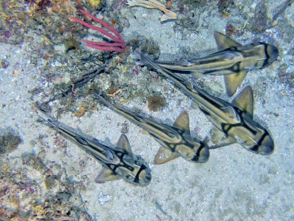
Image: Large aggregations of Port Jackson sharks occur in Beagle Marine Park (Institute for Marine and Antarctic Studies)
Park management is focused on the protection and conservation of values and, depending on zoning providing for ecologically sustainable use of the values. The Director achieves this by undertaking management actions, primarily to minimise the pressures on the values (Figure 3.1). Management actions include prescriptions, that is, the zoning and rules for activities specified in Chapter 4 of this plan. Additionally, other management actions outlined in Section 3.4 of this plan underpin the effective management of the parks.
The Director works closely in partnership with First Nations people, government agencies, marine park users and stakeholders to deliver a range of management actions. This partnership approach is essential to managing the marine parks and is outlined further in Section 3.3 of
this plan.
The values in the South-east Marine Parks Network (South-east Network) are subject to a range of cumulative impacts, including from broadscale pressures such as climate change. The Director acknowledges that park management may have limited direct influence on these broadscale pressures and that some ecological change may be unavoidable in the long term. The protection afforded by marine parks aims to increase resilience. In some cases, it may be possible and appropriate to implement park management actions at a localised level to help resist these ecological changes, improve ecosystem resilience or direct ecological change to a more desirable state. However, many interventions will not be feasible in deep, remote, offshore marine environments. In these cases, park management may focus on monitoring the impacts of broadscale pressures on marine park values to contribute to national responses.
When values are in good condition, they best support social and economic benefits – primarily by users who access and enjoy the natural resources in the parks. However, if levels of use are too high, or activities too damaging, these activities can become pressures and park values are at risk of becoming degraded. The condition of values can also be affected by a range of external biophysical and social and economic drivers (for example, oceanic currents, fuel prices, fish market prices) which are typically unable to be influenced by park management actions. However, these variables are important context to be aware of when trying to assess the effectiveness of different management approaches.
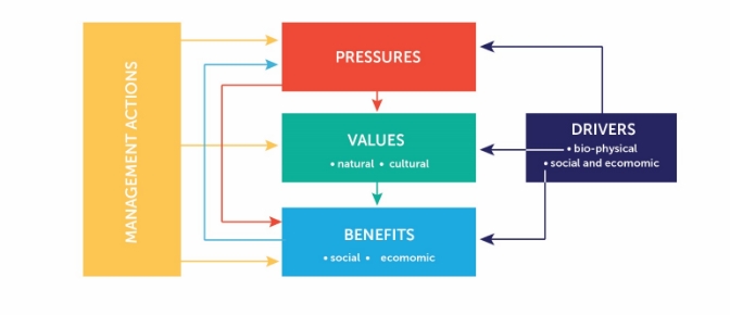
Figure 3.1 Australian Marine Park management model. The model shows the relationships between management actions, pressures, values, benefits and external drivers.
Parks Australia manages the Australian Marine Parks using an adaptive approach, consistent with Australia’s IUCN reserve management principles (Section 4.1). Effective and adaptive management is a systematic process for continual improvement that involves ongoing monitoring of management actions, evaluating their effectiveness in achieving stated objectives and adjusting management accordingly. Section 3.5 of this plan describes how the Director will monitor, evaluate and report on this plan to enable adaptive management of the marine parks.
In managing the South-east Network, the Director and Parks Australia staff will strive to be:
- Respectful – of the Traditional Owners of the sea, First Nations people, marine park users, stakeholders and other government agencies
- Collaborative – seeking to co-design management actions and systems wherever possible and manage in consultation with First Nations people and marine park users
- Balanced – focused on protecting natural and cultural values, while facilitating sustainable use and enjoyment of marine parks
- Outcomes-based – considering outcomes for natural and cultural values and social
and economic benefits of the South-east Network when making decisions about activities - Adaptive – encouraging innovation, accommodating new information about values, pressures, and technologies, and allowing for continual improvement in management
- Evidence- and risk-based – using information to guide management and
decision-making, including evidence gathered through monitoring, research,
evaluation and reporting - Proactive – taking proactive action to protect the South-east Network from pressures,
to minimise damage, and to improve resilience wherever possible - Efficient and effective – minimising regulatory burden and costs on businesses and individuals, including by using assessment and approval mechanisms of other government agencies, while enforcing the rules established in this plan.
Effective management of the South-east Network will be achieved by working with First Nations people, marine park users and stakeholders, and other government agencies through a range of partnership arrangements. Section 1.7 of this plan describes in more detail, the approach to partnering with Sea Country Traditional Owners.
Partnerships with government agencies
The Director will continue working in partnership with Commonwealth government agencies with critical roles in managing and understanding Australia’s marine environment, including the Australian Fisheries Management Authority; Department of Agriculture, Fisheries and Forestry; Australian Maritime Safety Authority; Department of Defence; Geoscience Australia; Australian Antarctic Division; Australian Border Force; National Offshore Petroleum Safety and Environmental Management Authority; Offshore Infrastructure Regulator; Department of Industry, Science and Resources; and Australian Space Agency.
The Director will also build on partnerships with the Tasmanian, Victorian and South Australian fisheries and marine park agencies and research institutions that support the day-to-day management of the South-east Network, while supporting a consistent approach to managing marine parks around Australia.
Partnerships with marine park users and stakeholders
To support collaborative management and achieve the vision for marine parks, the Director will work closely with marine park users and stakeholders to design and deliver management actions. This could include working with national, state/territory or local groups with an interest in the ongoing management of the South-east Network on a range of activities such as monitoring, citizen science, workshops, communications and outreach.
Advisory committees are a mechanism that can support the Director in effectively managing the marine parks by advising on implementation of this management plan and community and park user views, identifying knowledge gaps and assessing the impact of different management interventions.
The Director will establish a non-statutory South-east Marine Parks Advisory Committee, with membership available to a wide range of individuals interested and engaged in the ongoing management of the South-east Network. The Director will regularly review the function of this advisory committee during the life of this plan and may put in place different arrangements to better engage stakeholders in management.
Desired outcomes state what the Director aims to accomplish over the life of this management plan. They are a specific and measurable link between the management plan objectives and management actions. The desired outcomes in this plan are set at a high level due to the diversity of the 14 marine parks in the South-east Network. Over time, more specific and detailed desired outcomes may be developed at park and/or zone levels outside this plan.
To achieve each desired outcome, actions across a range of management programs will be required. Similarly, effective delivery of a management program can contribute to multiple desired outcomes.
Subject to resource availability, the Director will implement 4 management programs and associated actions to achieve desired outcomes (Table 3.1).
The management programs are:
- First Nations connections and partnerships The First Nations connections and partnerships program will manage Sea Country in partnership with First Nations people. It will be informed by the extent of Sea Country in the South-east Network, the aspirations of First Nations people, and the capacity of organisations to participate in marine park management. For some parks, where there is limited understanding of First Nations connections to Sea Country, program actions will seek to improve understanding of these connections and aspirations for Sea Country. For other parks, where Sea Country connections are clearer, actions will seek to support First Nations people’s engagement with management, recognising that Traditional Owners have interests in all aspects
of management. Feedback from Traditional Owners has shaped actions across all
4 programs.
- Protection and resilience The protection and resilience program will provide for ecologically sustainable use of the marine parks through transparent assessment and authorisations mechanisms, to enforce the rules set out in this plan and to manage and minimise the impacts of pressures on park values. The program may include actions to support ecosystem adaptation and resilience.
- Science and management effectiveness The science and management effectiveness program will provide the necessary scientific knowledge to inform adaptive management. This includes actions to improve understanding of marine park values, pressures, drivers and the effectiveness of management actions. Varying levels of knowledge exist across the network, with long-term monitoring programs in place in some parks, while knowledge of other parks is still relatively low.
- Communication and engagement The communication and engagement program will improve public awareness of marine park values and understanding of the rules in place to manage them, particularly as they apply to different user groups. In commencing this second management plan for the South-east Network, there remains scope for improving the awareness of the marine parks amongst coastal communities in the region and the broader Australian public. This program also seeks to build stakeholder participation in, and support for, marine park management.
The actions in Table 3.1 below describe the general bodies of work to be delivered over the life of the plan and may need to be adapted as new information and approaches become available. This will occur in consultation with the advisory committee, First Nations people and stakeholders. More specific actions will be identified and delivered through an annual operational planning cycle and in response to new information.
Table 3.1 Management programs and desired outcomes for the South-east Network
Vision | The South-east Marine Parks are healthy and resilient for current and future generations |
Objectives | - To protect and conserve biodiversity and other natural and cultural values
- Ecologically sustainable use and enjoyment of the natural resources within marine parks, where this is consistent with objective (a)
|
Desired outcomes | - Park users and stakeholders are aware of and appreciate the South-east Marine Parks
- Compliance rates increase throughout the first 2 years and then are high throughout the life of this plan
- First Nations people have increased opportunities to build connection to, and care for, Sea Country in Australian Marine Parks
- Key knowledge gaps are identified and addressed to support evidence-based management
- Mesophotic reef ecosystems (middle-light reefs in depths of 30 m to 70 m) in National Park Zones are in better condition relative to unprotected areas
- Rariphotic reef ecosystems (rare-light reefs in depths of 71 m to 200 m) in National Park Zones are in better condition relative to unprotected areas
- Canyon ecosystems in National Park Zones are in better condition relative to unprotected areas
- Seamount reef ecosystems are continuing to show signs of recovery from historic trawl fishing
|
Management programs | First Nations connections and partnerships | Protection and resilience | Science and management effectiveness | Communication and engagement |
Goals | Respect and support the ongoing cultural responsibilities and connections of First Nations people to care for and manage Sea Country in marine parks | Reduce the impacts of pressures and environmental changes on marine species, habitats and ecosystems | Identify and deliver priority science needs to inform adaptive management | Enhance public appreciation, understanding of, and engagement in, marine parks and their management |
Actions | - Co-design a Sea Country Strategy with Traditional Owners to identify priorities for First Nations-led projects and actions
- Seek the active participation of Traditional Owners in the identification and management of First Nations values in marine parks through the development of First Nations values statements
- Work with Traditional Owners to develop and maintain an information management system that houses information about First Nations values and management considerations
- Implement cultural awareness and competency training for Parks Australia staff in association with the Traditional Owners of the south-east region
- Engage with Traditional Owners through culturally appropriate and culturally safe mechanisms, including the South-east Saltwater Council
- Establish collaborative arrangements with First Nations groups in the management of South-east Marine Parks
- Develop and implement a process with Traditional Owners to dual or rename parks in advance of the next management plan
- Ensure dedicated resources are allocated to support First Nations engagement in the management of South-east Marine Parks
| - Assess applications and authorise activities in accordance with the management plan to provide for sustainable activities in the parks
- Undertake surveillance, education and enforcement operations to support high levels of compliance
- Prepare for a range of critical incidents and support maritime emergency agencies respond to events in or near the marine parks
- Enhance ecosystem resilience and support the management of broadscale pressures (e.g. climate change, marine debris, invasive marine species), including through advocacy and collaboration with other management agencies and jurisdictions
- Explore novel and effective approaches to ecosystem restoration and adaptation
| - Continue to build and maintain robust, collaborative, and cost-effective partnerships to deliver quality science
- Encourage, enable and commission discovery research, and research in response to new uses, existing and emerging pressures
- Monitor the status of priority park values and social and economic trends
- Continue to explore opportunities to better weave Indigenous knowledge systems and Western science, ensuring all perspectives are valued and inform adaptive management
- Develop and maintain data and information systems, processes and reporting to support evidence-based park management, in conjunction with partners
- Share findings of research and monitoring programs with park users, First Nations people, stakeholders, partners, other government agencies and the public
- In partnership with relevant recreational fishing organisations, identify priorities to better understand recreational fishing effort, benefits and impacts in the South-east Network
- Evaluate and report on the effectiveness of management actions
- Explore novel and effective approaches to monitoring and research
| - Develop clear and concise materials that enhance the accessibility of management arrangements in the South-east
- Prepare a range of information products and maintain a strong visual presence to build public awareness of marine parks and their management (including through social media platforms)
- Engage with coastal communities and other interested stakeholders to build understanding of South-east Marine Parks and their management (including through attendance at events)
- Educate marine park users about the marine park rules and their requirements
- Support sustainable use of the parks by providing information about park values and ways marine park users can contribute to the protection of the park values
- Establish and maintain partnerships with a range of stakeholders to provide advice that will collectively inform park management
|
Assessing management effectiveness for the Australian Marine Parks requires consideration
of values, benefits, pressures and management approaches, all within the context of various external drivers.
The Director will undertake periodic monitoring, evaluation and reporting on the implementation of this plan to:
- identify changes in management context and priorities
- prioritise future management actions
- consider the adequacy of knowledge of marine park values, benefits, pressures and management approaches
- determine the effectiveness of management actions in achieving objectives, desired outcomes and goals
- review the effectiveness of zoning and associated rules in achieving park objectives
- inform the development of a new management plan for the South-east Network at the conclusion of this plan.
Monitoring, evaluation and reporting will occur over the life of this management plan in a manner that ensures park managers, the advisory committee, First Nations people and stakeholders have access to relevant information about park and management performance, consistent with the points outlined above. Specific reporting arrangements will be developed to meet these diverse needs, while also supporting the Director’s overall annual corporate planning and performance reporting requirements.
In the final stages of this management plan, a comprehensive review will be undertaken
to evaluate the effectiveness of this plan and inform the third management plan for the
South-east Network.

Image: Fishing fleet (Department of Climate Change, Energy, the Environment and Water)
Zoning and related prescriptions for managing activities are important tools to ensure protection of marine park values, while enabling different types of use. In determining the zones and rules, the Director has considered the best available science, the advice of stakeholders and First Nations groups (including through formal statutory consultations), the goals and principles of the National Representative System of Marine Protected Areas, and the Australian IUCN reserve management principles.
Effective marine park management requires the implementation of management programs
and actions (described in Chapter 3) to fully give effect to the zoning and rules described in
this chapter.
The EPBC Act requires this plan to assign an IUCN category to each marine park. The EPBC Act also allows this plan to further divide a marine park into zones and to assign a category to each zone, which may differ from the overall category of the marine park.
This section (4.1) assigns an IUCN category to each marine park of the South-east Network, divides some marine parks into zones with their own category and sets out the objectives for each zone (Table 4.1). Zoning takes into account the purposes for which the marine parks were declared, the objectives of this plan (Section 1.6), the values of the network (Section 2.3 and Schedule 1), and the requirements of the EPBC Act and Environment Protection and Biodiversity Conservation Regulations 2000 (EPBC Regulations). Figure 4.1 and the maps in Schedule 1 show the zones assigned to the South-east Network, Schedule 3 describes the park boundaries and zones assigned, and the management approach applied to activities within these zones is provided in Section 4.3 (Prescriptions for activities). An overview of the South-east Network marine parks and zones is provided in Schedule 1, Table S1.1.
Prescriptions
- Each marine park in the South-east Network specified in Table 4.1 is assigned to the IUCN category specified in column 2 of Table 4.1.
- Apollo, Boags, East Gippsland, Nelson and South Tasman Rise Marine Parks are given the zone name specified in column 3 of Table 4.1, adjacent to the name of the marine park (column 1).
- Beagle, Flinders, Franklin, Freycinet, Huon, Macquarie Island, Murray, Tasman Fracture and Zeehan Marine Parks are each divided into the zones shown in Figure 4.1 and more specifically shown in marine park maps in Schedule 1 and described in Schedule 3. Each zone is assigned to an IUCN category and given the zone name specified in column 3 of Table 4.1, adjacent to the name of the marine park (column 1).
- The objective of a Multiple Use Zone (VI) is to provide for ecologically sustainable use and the conservation of ecosystems, habitats and native species.
- The objective of a Special Purpose Zone (VI) is to provide for ecologically sustainable use and the conservation of ecosystems, habitats and native species, while providing for the continued use of existing mining rights.
- The objective of a Habitat Protection Zone (IV) is to provide for the conservation of ecosystems, habitats and native species in as natural a state as possible, while allowing activities that do not harm or cause destruction to seafloor habitats.
- The objective of a Habitat Protection Zone (Macquarie) (IV) is to provide for the conservation of ecosystems, habitats and native species in as natural state as possible, while allowing activities that do not harm or cause destruction to pelagic environments.
- The objective of a Recreational Use Zone (IV) is to provide for the conservation of ecosystems, habitats and native species in as natural a state as possible, while providing for recreational use.
- The objective of a National Park Zone (II) is to provide for the protection and conservation of ecosystems, habitats and native species in as natural a state as possible.
- The objective of a Sanctuary Zone (Ia) is to provide for the conservation of ecosystems, habitats and native species in as natural and undisturbed a state as possible.
Table 4.1 South-east Network zoning and marine park management categories
| Column 3 - Zone name and IUCN category |
Column 1 Marine park name | Column 2 IUCN category | Multiple Use
Zone (VI) | Special Purpose Zone (VI) | Habitat Protection Zone (IV) | Habitat Protection Zone (Macquarie) (IV) | Recreational Use
Zone (IV) | National Park Zone (II) | Sanctuary Zone |
East Gippsland | | ✓ | | | | | | |
Beagle | | ✓ | | | | | ✓ | |
Flinders | | ✓ | | ✓ | | | ✓ | |
Freycinet | | ✓ | | ✓ | | ✓ | ✓ | |
Huon | | ✓ | | | | | ✓ | |
South Tasman Rise | | | | | | | ✓ | |
Tasman Fracture | | ✓ | | | | | ✓ | |
Zeehan | | ✓ | ✓ | | | | ✓ | |
Franklin | | ✓ | | | | | ✓ | |
Boags | | ✓ | | | | | | |
Apollo | | ✓ | | | | | | |
Nelson | | | | | | | ✓ | |
Murray | | ✓ | | ✓ | | | ✓ | |
Macquarie Island | | | | | ✓ | | ✓ | ✓ |
✓ Zone is assigned to the marine park named in column 1. Prescriptions 4.1.2 and 4.1.3 of this plan explain the assignment of zones.
Note: The South-east Network has 2 types of Habitat Protection Zone (IV): Habitat Protection Zone (IV) and Habitat Protection Zone (Macquarie) (IV). The variation in management approach for this zone category is prescribed in Section 4.3 (Prescriptions for activities).
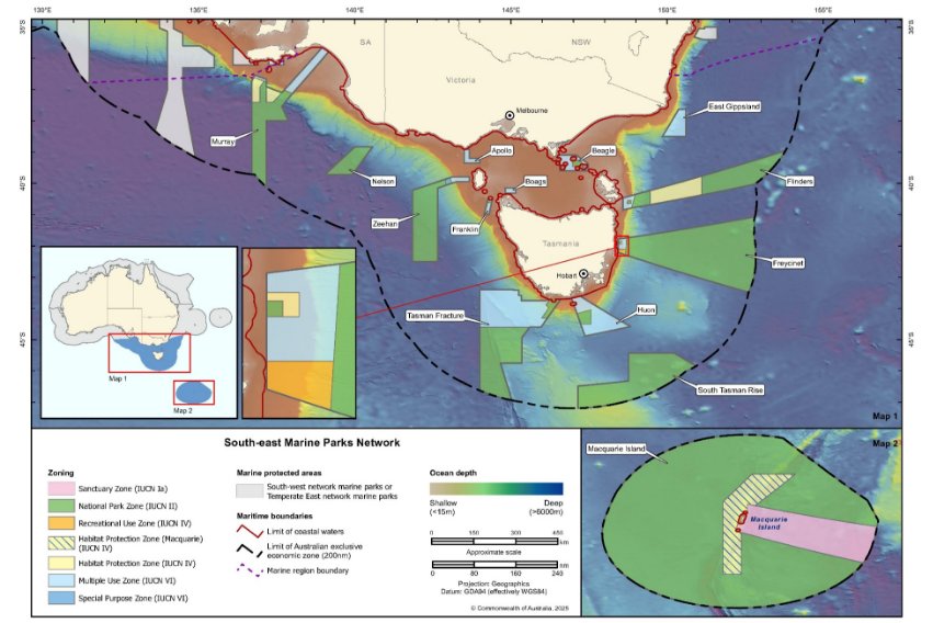
This plan enables a range of activities to be carried out in the South-east Network that would otherwise be prohibited or controlled by Division 4 of Part 15 of the EPBC Act and Part 12 of the EPBC Regulations.
Chapter 4 sets out, for marine parks of the South-east Network, which activities are:
- allowed, without the need for separate authorisation, where consistent with IUCN zone objectives (Section 4.1) and carried out in accordance with this chapter
- allowable and able to be carried out if a separate authorisation is issued (Section 4.5 Authorisation of activities); or
- not allowed, because they are not consistent with zone objectives (Section 4.1).
Chapter 4 also sets out:
- the assessment and decision-making process for authorising an activity (Section 4.4 Making decisions about activities)
- the types of authorisations that may be issued (permits, class approvals, activity licences and leases) (Section 4.5 Authorisation of activities)
- how activities must be undertaken in the South-east Network (Section 4.3 Prescriptions for activities).
The prescriptions support an adaptive management approach to respond to new information. Any changes to the management of activities would be made in accordance with Section 4.4.1 (Decision-making). The Director may provide additional guidance (for example, consultation guidelines) outside this plan to support the assessment process.
Under the EPBC Regulations, the Director may make a determination to place additional restrictions on activities that are allowed or allowable according to this plan, if park objectives are not being met.
In accordance with section 359A of the EPBC Act, this plan does not prevent Indigenous people from continuing, in accordance with law, the traditional use of an area in a marine park for non‑commercial hunting or food gathering and for ceremonial and religious purposes. Section 8 of the EPBC Act provides that this plan does not affect the operation of the Native Title Act 1993 (Cth), which also includes provisions that preserve customary rights to use land and waters (Schedule 2).
Depending on the type of activity, other provisions of the EPBC Act, EPBC Regulations or other legislation (for example, fisheries laws) may also apply to an allowed or allowable activity (Schedule 2).
It is the responsibility of the person proposing to take the action to obtain any required approvals under the EPBC Act, EPBC Regulations or other legislation. This includes:
- determining whether the proposed action should be referred to the Minister in accordance with Parts 7 and 8 of the EPBC Act to determine whether it is a controlled action
- if it is a controlled action, obtaining the required approvals for the action under Part 9 of the EPBC Act.
The Director may also refer a proposed action to the Minister to determine whether it is a controlled action under Parts 7 and 8 of the EPBC Act.
Interactions with cetaceans such as whales, dolphins and porpoises in the Australian Whale Sanctuary (which the South-east Network is a part of) are additionally, and separately, regulated under Part 8 of the EPBC Regulations. This plan does not purport to provide authorisation or exemption for any offences under Part 8 of the EPBC Regulations for commercial tourism activity taking place in any section of the South-east Network that overlaps with the Australian Whale Sanctuary.
This plan enables activities to be carried out in zones consistent with the zone objectives (Section 4.1) while enabling the impacts to be effectively managed. Prescriptions for these activities are summarised in Table 4.2.
The prescriptions in this plan relate to activities that are either:
- not regulated by the EPBC Act or Regulations and need to be regulated to meet the objectives of this plan, or
- prohibited by the EPBC Act or Regulations but enabled by this plan, which overrides the offence provisions in relation to those activities set out in the EPBC Act and Regulations (section 362(3) of the EPBC Act).
For activities not regulated under this plan, the EPBC Act and Regulations continue to set out the rules in the South-east Network (Section 2.1.3 in Schedule 2 provides an overview of activities regulated in Commonwealth reserves). In broad terms, these activities are prohibited by the EPBC Act and Regulations, unless an exemption applies.
All activity tables in this chapter should be read in conjunction with the relevant prescriptions.
Table 4.2 Summary of prescriptions for activities in the South-east Network (Note: this is a high-level summary table. For detailed prescriptions, refer to Sections 4.3.1–4.3.14).
Activity | Multiple Use Zone
(IUCN VI) | Special Purpose Zone (VI) | Habitat Protection Zone
(IUCN IV) | Habitat Protection Zone (Macquarie) (IV) | Recreational Use Zone (IUCN IV) | National Park Zone (IUCN II) | Sanctuary Zone
(IUCN Ia) | |
GENERAL USE,
ACCESS AND
WASTE
MANAGEMENT (Section 4.3.1) (Section XX)
(Section XX)
(Section XX)
| ✓ | ✓ | ✓ | ✓ | ✓ | ✓ | ✓ | |
COMMERCIAL
FISHING (Section 4.3.2) | A | x | A | A | x | x | x | |
COMMERCIAL AQUACULTURE (Section 4.3.3) | x | x | x | x | x | x | x | |
COMMERCIAL
TOURISM (Section 4.3.4)
| A | A | A | A | A | A | x | |
COMMERCIAL
MEDIA (Section 4.3.5)
| A | A | A | A | A | A | A | |
RECREATIONAL
USE (Section 4.3.6) | ✓ | ✓ | ✓ | ✓ | ✓ | ✓ | x | |
OFFSHORE WIND ENERGY (Section 4.3.7) | x | x | x | x | x | x | x | |
MINING (Section 4.3.8) | xP | xP | x | x | x | x | x | |
CARBON CAPTURE AND STORAGE (Section 4.3.9) | x | x | x | x | x | x | x | |
SPACE ACTIVITIES (Section 4.3.10) | A | A | x | x | x | x | x | |
STRUCTURES
AND WORKS (Section 4.3.11) | A | A | A | A | A | A | x | |
RESEARCH AND
MONITORING (Section 4.3.12) | A | A | A | A | A | A | A | |
NATIONAL
SECURITY AND
EMERGENCY
RESPONSE (Section 4.3.13) | ✓ | ✓ | ✓ | ✓ | ✓ | ✓ | ✓ | |
| | | | | | | | |
✓ Activity is allowed in accordance with the prescriptions of this plan without the need for a permit, class approval or activity licence or lease issued by the Director.
x Activity is not allowed.
A Authorisation is required. Activity is allowable, subject to assessment, in accordance with a permit, class approval or activity licence or lease issued by the Director.
xP Only allowable in Zeehan Marine Park, where the activity is within an Existing petroleum title that was granted under the Offshore Petroleum and Greenhouse Gas Storage Act 2006 (Cth) prior to the commencement of this plan, or subsequent title in the same area.
This section (4.3.1) applies to all marine park users of the South-east Network, including those carrying out activities provided for under this plan. These are summarised in Table 4.3.
The EPBC Act and EPBC Regulations permit or enable the Director to control a range of activities in marine parks. Some provisions apply to particular classes of activities, such as commercial activities, mining operations or research. Other provisions (Schedule 2) relate to activities generally and include provisions enabling the Director to:
- determine areas where waste may be disposed of
- prohibit or restrict entry or activities
- determine adventurous activities and areas where adventurous activities may be done
- make determinations about the use of vessels, including to prohibit use, control anchoring and mooring, and set speed limits
- make determinations about the use of aircraft in and over marine parks.
The taking-off and landing of an aircraft in a marine park can only be carried out in an area determined by the Director (regulation 12.58, EPBC Regulations).
Australia is a party to a number of international agreements relevant to commercial shipping in particular, the United Nations Convention on the Law of the Sea (UNCLOS) and International Convention for the Prevention of Pollution from Ships (MARPOL) (Schedule 2). UNCLOS provides a right of innocent passage through the territorial sea for foreign vessels and a right of freedom of navigation through Australia’s Exclusive Economic Zone. This section (4.3.1) places some limits on the exercise of these rights in some zones. The limitations are necessary to protect marine park values, apply to all commercial shipping and are intended to be consistent with Australia’s rights and obligations under UNCLOS.
There are also a range of national laws, policies and procedures relevant to commercial shipping including the National Plan for Maritime Environmental Emergencies in relation to maritime pollution incidents and the Biosecurity Act 2015 (Cth) and Australian ballast water management requirements in relation to ballast water discharge. Prescriptions dealing with waste disposal and ballast water discharge and exchange are also covered in this section (4.3.1).
Vessel transiting and anchoring will be managed in accordance with this section (4.3.1) subject to relevant conditions in commercial fishing (Section 4.3.2), commercial tourism (Section 4.3.4), recreational use (Section 4.3.6), research and monitoring (Section 4.3.12) and national security and emergency response (Section 4.3.13).
The EPBC Regulations prohibit disposal of domestic and industrial waste, and the operation of aircraft (including drones), in Australian Marine Parks unless authorised by or under a management plan. This section (4.3.1) outlines how these activities can be carried out in the South-east Marine Park Network and any authorisations that may be required.
Waste from normal operations of vessels must be compliant with the requirements under MARPOL as they exist at the time this management plan comes into effect, the International Maritime Organization convention covering prevention of pollution of the marine environment by ships from operational or accidental causes. Ballast water discharge and exchange must be compliant with ballast water management requirements under the Biosecurity Act 2015.
Table 4.3 Summary of prescriptions for general use, access and waste management in the South-east Network
GENERAL USE, ACCESS AND WASTE MANAGEMENT | Multiple Use
Zone (VI) | Special Purpose Zone (VI) | Habitat Protection Zone (IV) | Habitat Protection Zone (Macquarie) (IV) | Recreational Use
Zone (IV) | National Park Zone (II) | Sanctuary Zone (Ia) |
Vessel transiting | ✓ | ✓ | ✓ | ✓ | ✓ | ✓ | x |
Anchoring | ✓ | ✓ | xC | xC | xC | xC | x |
Ballast water discharge and exchange (compliant with Australian ballast water requirements) | ✓ | ✓ | ✓ | ✓ | ✓ | ✓ | x |
Disposal of waste from normal operations of vessels (compliant with MARPOL requirements) | ✓ | ✓ | ✓ | ✓ | ✓ | ✓ | x |
Disposal of domestic and industrial waste | A | A | x | x | x | x | x |
Non-commercial remote piloted aircraft, drones etc. | ✓ | ✓ | ✓ | ✓ | ✓ | ✓ | x |
✓ Activity is allowed in accordance with the prescriptions of this plan without the need for a permit, class approval or activity licence or lease issued by the Director.
A Authorisation required. Activity is allowable, subject to assessment, in accordance with a permit, class approval or activity licence or lease issued by the Director.
x Activity is not allowed.
xC Anchoring is not allowed except in anchoring areas determined under regulation 12.56 of the EPBC Regulations.
Prescriptions
4.3.1.1 The Director may issue an authorisation for an activity that would otherwise be prohibited, restricted or the subject of a determination under the EPBC Regulations.
4.3.1.2 Vessels may transit through the South-east Network except the Sanctuary Zone (Ia) for the purpose of conducting activities in or outside the network, subject to compliance with the prescriptions in this section (4.3.1) and relevant prescriptions in Sections 4.3.2–4.3.13 relating to specific activities.
4.3.1.3 Vessels may stop and anchor:
a) in a Multiple Use Zone (VI) and Special Purpose Zone (VI)
b) in anchoring areas determined under regulation 12.56 of the EPBC Regulations in a Habitat Protection Zone (IV), Habitat Protection Zone (Macquarie) (IV), Recreational Use Zone (IV) and National Park Zone (II).
4.3.1.4 The limitations on anchoring in this section (4.3.1) do not apply to anchoring that occurs as part of activities that are allowed or allowable under Sections 4.3.24.3.12 of this plan and regulation 12.56 of the EPBC Regulations.
4.3.1.5 Disposal of domestic and industrial waste may be carried out in a Multiple Use Zone (VI) or Special Purpose Zone (VI) in the South-east Network under:
a) a permit issued under Section 4.5.2 (Permits)
b) a class approval issued under Section 4.5.3 (Class approvals)
c) an activity licence issued under Section 4.5.4 (Activity licences and leases) to a person who is not covered by a class approval.
4.3.1.6 Without limiting Section 4.3.1.5, the disposal of domestic and industrial waste must also comply with any determinations made under regulations 12.14–12.14B of the EPBC Regulations.
4.3.1.7 Waste from normal vessel operations must be disposed of in accordance with the relevant requirements of MARPOL as it exists in force on the date this plan comes into effect.
4.3.1.8 Ballast water can only be discharged or exchanged if in compliance with the Biosecurity Act 2015 (Cth).
4.3.1.9 Disposal of waste in connection with activities authorised under Section 4.3.11 (Structures and works) will be managed in accordance with that section.
4.3.1.10 Overnight stays on vessels do not require a permit to camp.
4.3.1.11 Remotely piloted aircraft may be operated for non-commercial purposes in all zones;
a) without further authorisation from the Director, except in a Sanctuary Zone (Ia), where it is not permitted at all, and
b) subject to Sections 4.3.1.13 and 4.3.1.14
4.3.1.12 Remotely piloted aircraft may be operated for commercial purposes;
a) in accordance with a relevant authorisation granted for an activity in Sections 4.3.2–4.3.14, and
b) subject to Sections 4.3.1.13 and 4.3.1.14.
4.3.1.13 All remotely piloted aircraft will need to be in accordance with and subject to:
a) applicable aviation safety laws as administered by the Civil Aviation Safety Authority
b) relevant provisions of Part 8 of the EPBC Regulations relating to whale watching and other interactions with cetaceans
c) other Commonwealth and state legislation relevant to remotely piloted aircraft
d) any relevant determinations made under the EPBC Regulations.
4.3.1.14 Pilots of remotely piloted aircraft must ensure their aircraft:
a) does not approach birds from higher than a 60-degree angle or at speeds exceeding 3 m per second,
b) is launched and operated as far as practicable from groups of birds and nesting birds, and
c) is immediately landed if wildlife exhibits signs of disturbance for example fleeing, sudden alteration of course or direction, attacking the remotely piloted aircraft (drone) or being put to flight.
This section (4.3.2) sets out the rules for commercial fishing activities in the South-east Network, including the types of fishing gear and methods allowed in different zones and requirements for real-time location data. These are summarised in Table 4.4.
Commercial fishing is managed for sustainability by the Australian Government and state and territory fisheries management agencies. In the South-east Network, commercial fishing is
subject to regulation under the Fisheries Management Act 1991 (Cth), or South Australian, Tasmanian or Victorian fisheries laws (under arrangements made under Part V of the Fisheries Management Act).
Table 4.4 Summary of prescriptions for commercial fishing activities in the
South-east Network
COMMERCIAL FISHING | Multiple Use
Zone (VI) | Special Purpose Zone (VI) | Habitat Protection Zone (IV) | Habitat Protection Zone (Macquarie) (IV) | Recreational Use
Zone (IV) | National Park Zone (II) | Sanctuary Zone (Ia) |
Danish seine | x | x | x | x | x | x | x |
Dropline | A | x | x | x | x | x | x |
Hand collection (including using hookah, scuba, snorkel) | A | x | A | x | x | x | x |
Hand net (hand, barrier, skimmer, cast, scoop, drag, lift) | A | x | A | x | x | x | x |
Longline (demersal, auto-longline) | A | x | x | A | x | x | x |
Longline (pelagic) | A | x | A | x | x | x | x |
Minor line (handline, rod and reel, trolling, squid jig, poling) | A | x | A | x | x | x | x |
Net (demersal) | A | x | x | x | x | x | x |
Net (pelagic) | x | x | x | x | x | x | x |
Purse seine | A | x | A | x | x | x | x |
Scallop dredging | x | x | x | x | x | x | x |
Trap, pot | A | x | x | A | x | x | x |
Trawl (demersal) | x | x | x | x | x | x | x |
Trawl (midwater) | A | x | A | x | x | x | x |
Trotline | A | x | x | x | x | x | x |
A Authorisation is required. Activity is allowable, subject to assessment, in accordance with a permit, class approval or activity licence issued by the Director.
x Activity is not allowed.
Note: Commercial fishing methods not listed in Table 4.5 will require assessment and approval in accordance with Section 4.3.14 (New activities and authorisations).
Note: A class approval or activity licence may be varied under Section 4.5 (Authorisation of activities) to specify additional fishing methods and gear types following satisfactory assessment in accordance with Section 4.4.1 (Decision-making).
Note: Transit by commercial fishing vessels will be managed in accordance with Section 4.3.1 (General use, access and waste management) and prescriptions 4.3.2.4 and 4.3.2.6 in this section. Anchoring is allowed as part of activities authorised under this section (4.3.2).
Note: Research in connection with commercial fishing activities will be managed in accordance with Section 4.3.12 (Research and monitoring).
Prescriptions
4.3.2.1 Commercial fishing activities must only be carried out in a Multiple Use Zone (VI), Habitat Protection Zone (IV), or Habitat Protection Zone (Macquarie) (IV), and are subject to the prescriptions in this section (4.3.2).
4.3.2.2 Commercial fishing activities (including fish processing and the towing of caught fish) may be carried out in the South-east Network under:
a) a permit issued under Section 4.5.2 (Permits)
b) a class approval issued under Section 4.5.3 (Class approvals)
c) an activity licence issued under Section 4.5.4 (Activity licences and leases) to a person who is not covered by a class approval.
4.3.2.3 Without limiting prescription 4.3.2.2, all commercial fishing activities must also comply with:
a) the prescriptions in Section 4.3.1 (General use, access and waste management), where applicable,
b) any determinations made under regulation 12.34 of the EPBC Regulations, and
c) any commercial fishing concession issued under Commonwealth, state or territory fisheries laws to the extent those laws are capable of operating concurrently with this plan.
4.3.2.4 All commercial fishing vessels are required to provide real-time location data when operating or transiting through an Australian Marine Park in accordance with the conditions of the relevant class approval.
4.3.2.5 Where commercial fishing activities involve the below, the following prescriptions apply:
a) The following fishing gear must not be used anywhere in the network:
i. Danish seine
ii. net (pelagic)
iii. scallop dredging
iv. trawl (demersal).
b) Towing of caught fish and fish processing may be carried out in all zones except a Sanctuary Zone (IUCN Ia), in accordance with any conditions in an approval granted under Section 4.5.
c) Longline (demersal, auto-longline) and traps and pots may only be used in a Multiple Use Zone (VI) and Habitat Protection Zone (Macquarie) (IV).
d) Hand collection, hand net, longline (pelagic), minor line, purse seine and midwater trawl may only be used in a Multiple Use Zone (VI) and Habitat Protection Zone (IV).
e) dropline, net (demersal) and trotline may only be used in a Multiple Use
Zone (VI).
4.3.2.6 Fishing gear that is:
a) not allowed in the South-east Network (4.3.2.5(a)) or a certain zone within the South-east Network (4.3.2.5(c)(e))
b) not specified in a permit, class approval or activity licence as gear that may be used, or
c) prohibited by a determination under regulation 12.34 of the EPBC Regulations,
must be kept stowed and secured at all times during transit through, or while stopping and anchoring in, zones in which that gear is not allowed.
This section (4.3.3) sets out the rules for commercial aquaculture in the South-east Network. These are summarised in Table 4.5.
Commercial aquaculture in the region is managed under Victorian, Tasmanian and South Australian laws. These laws apply to the extent that they can operate consistently with the
EPBC Act, the EPBC Regulations and this plan.
Commercial intensive aquaculture is not allowed in the South-east Network.
The Director may make determinations under regulation 12.34 of the EPBC Regulations relating to the conduct of commercial aquaculture.
Table 4.5 Summary of prescriptions for commercial aquaculture activities in the
South-east Network
COMMERCIAL AQUACULTURE | Multiple Use
Zone (VI) | Special Purpose Zone (VI) | Habitat Protection Zone (IV) | Habitat Protection Zone (Macquarie) (IV) | Recreational Use
Zone (IV) | National Park Zone (II) | Sanctuary Zone (Ia) |
Commercial intensive aquaculture | x | x | x | x | x | x | x |
Commercial aquaculture (other) | A | x | A | x | x | x | x |
A Authorisation is required. Activity is allowable, subject to assessment, in accordance with a permit, class approval or activity licence issued by the Director.
x Activity is not allowed.
Note: Examples of commercial aquaculture (other) may include seaweed, shellfish or bivalves.
Note: Anchor and transit by commercial aquaculture vessels will be managed in accordance with Section 4.3.1 (General use, access and waste management) and prescription 4.3.3.5.
Note: Cage towing will be managed in accordance with Section 4.3.2 (Commercial fishing).
Note: Research in connection with commercial aquaculture activities will be managed in accordance with Section 4.3.12 (Research and monitoring).
Prescriptions
- Commercial intensive aquaculture is not allowed in the South-east Network.
- Commercial aquaculture (that does not include intensive aquaculture) may be carried out in a Multiple Use Zone (VI) and Habitat Protection Zone (IV) and is subject to the prescriptions in this section (4.3.3).
- Commercial aquaculture (that does not include intensive aquaculture) may only be carried out under:
a) a class approval issued under Section 4.5.3 (Class approvals), or
b) an activity licence or lease issued under Section 4.5.4 (Activity licences and leases).
- Without limiting prescription 4.3.3.3, commercial aquaculture (that does not include intensive aquaculture) must be carried out in accordance with:
a) any determinations made under regulation 12.34 of the EPBC Regulations, and
b) any applicable Commonwealth and state laws to the extent those laws are capable of operating concurrently with this plan.
- Commercial aquaculture equipment not authorised for use by a class approval or activity licence as gear that may be used or that is prohibited by a determination under regulation 12.34 of the EPBC Regulations must be kept stowed and secured at all times during transit through, or while stopping and anchoring in, zones in which that gear is not allowed.
This section (4.3.4) sets out the rules for commercial tourism in the South-east Network. These are summarised in Table 4.6.
Table 4.6 Summary of prescriptions for commercial tourism (includes charter fishing tours) in the South-east Network
COMMERCIAL TOURISM | Multiple Use
Zone (VI) | Special Purpose Zone (VI) | Habitat Protection Zone (IV) | Habitat Protection Zone (Macquarie) (IV) | Recreational Use
Zone (IV) | National Park Zone (II) | Sanctuary Zone (Ia) |
Non-fishing related commercial tourism (including nature watching, scuba/snorkel tours) | A | A | A | A | A | A | x |
Commercial charter fishing tours (including spear diving tours) | A | x | A | A | A | x | x |
Commercial aviation tours (up to 3,000 m above sea level) | A | A | A | A | A | A | A |
A Authorisation is required. Activity is allowable, subject to assessment, in accordance with a permit, class approval or activity licence or lease issued by the Director.
x Activity is not allowed.
Note: Transit by commercial tourism vessels will be managed in accordance with Section 4.3.1 (General use, access and waste management) and prescription 4.3.4.4. Anchoring is allowed as part of activities authorised under this section (4.3.4).
Note: The prescriptions in Section 4.3.6 (Recreational use) apply to the clients of charter fishing tours.
Note: The prescriptions in Section 4.3.11 (Structures and works) apply to the installation and maintenance of moorings and other structures and works as part of commercial tourism activities.
Note: The EPBC Act and EPBC Regulations do not apply to commercial aviation tours in airspace over 3,000 m above sea level.
Prescriptions
4.3.4.1 Commercial tours, other than aviation tours up to 3,000 m above
sea level and charter fishing tours, can be carried out in all zones except the Sanctuary Zone (Ia).
4.3.4.2 Commercial aviation tours up to 3,000 m above sea level can be carried out in
all zones.
4.3.4.3 Commercial charter fishing tours can be carried out in all zones except the Special Purpose Zone (VI), National Park Zone (II) and Sanctuary Zone (Ia).
4.3.4.4 Commercial tourism activities, including aviation tours carried out in the airspace up to 3,000 m above sea level and charter fishing tours, may only be carried out in the South-east Network in accordance with and subject to:
a) a permit issued under Section 4.5.2 (Permits),
b) a class approval issued under Section 4.5.3 (Class approvals), or
c) an activity licence or lease issued under Section 4.5.4 (Activity licences and leases).
4.3.4.5 Without limiting prescription 4.3.4.4, all commercial tourism activities must comply with:
a) the prescriptions in Section 4.3.1 (General use, access and waste management) where applicable, and
b) if the commercial tourism activity involves charter fishing – the prescriptions in Section 4.3.6 (Recreational use).
4.3.4.6 Fishing gear on charter fishing vessels must be kept stowed and secured at all times during transit through, or stopping and anchoring in, zones in which charter fishing tours are not allowed.
This section (4.3.5) sets out the rules for commercial media in the South-east Network. These are summarised in Table 4.7.
Table 4.7 Summary of prescriptions for commercial media activities in the
South-east Network
COMMERCIAL MEDIA | Multiple Use
Zone (VI) | Special Purpose Zone (VI) | Habitat Protection Zone (IV) | Habitat Protection Zone (Macquarie) (IV) | Recreational Use
Zone (IV) | National Park Zone (II) | Sanctuary Zone (Ia) |
Commercial media | A | A | A | A | A | A | A |
News of the day reporting | ✓ | ✓ | ✓ | ✓ | ✓ | ✓ | ✓ |
✓ Activity is allowed in accordance with the prescriptions of this plan without the need for a permit, class approval or activity licence or lease issued by the Director.
A Authorisation is required. Activity is allowable, subject to assessment, in accordance with a permit, class approval or activity licence or lease issued by the Director.
Note: Transit by commercial media vessels will be managed in accordance with Section 4.3.1 (General use, access and waste management).
Note: Anchoring is allowed as part of activities allowed or authorised under this section (4.3.5).
Prescriptions
4.3.5.1 Commercial media activities, other than reporting news of the day, can only be carried out under:
a) a permit issued under Section 4.5.2 (Permits)
b) an activity licence issued under Section 4.5.4 (Activity licences and leases).
4.3.5.2 Without limiting prescription 4.3.5.1, all commercial media activity must comply with the prescriptions in Section 4.3.1 (General use, access and waste management).
4.3.5.3 Commercial media activities for the purposes of reporting news of the day may be undertaken without an authorisation. However, persons undertaking news of the day reporting must comply with any written or verbal directions issued by the Director in relation to the conduct of those activities.
This section (4.3.6) sets out the rules for recreational use (including non-commercial fishing) in the South-east Network. These are summarised in Table 4.8.
Table 4.8 Summary of prescriptions for recreational use (including fishing) activities in the South-east Network
RECREATIONAL USE (INCLUDING FISHING) | Multiple Use
Zone (VI) | Special Purpose Zone (VI) | Habitat Protection Zone (IV) | Habitat Protection Zone (Macquarie) (IV) | Recreational Use
Zone (IV) | National Park Zone (II) | Sanctuary Zone (Ia) |
Recreational fishing | ✓ | x | ✓ | ✓ | ✓ | x | x |
Recreational use (non-fishing, nature watching, boating, etc.) | ✓ | ✓ | ✓ | ✓ | ✓ | ✓ | x |
Activity is allowed in accordance with the prescriptions of this plan without the need for a permit, class approval or activity licence or lease issued by the Director.
x Activity is not allowed.
Note: Transit by recreational use vessels will be managed in accordance with Section 4.3.1 (General use, access and waste management) and prescription 4.3.6.6.
Note: Anchoring is allowed as part of activities allowed under this section (4.3.6).
Note: Research in connection with recreational fishing will be managed in accordance with Section 4.3.12 (Research and monitoring).
Prescriptions
4.3.6.1 Recreational use (including fishing) may be carried out in the South-east Network in accordance with:
a) the prescriptions in Section 4.3.1 (General use, access and waste management)
b) any determinations made under regulation 12.35 of the EPBC Regulations.
4.3.6.2 Recreational use that is not fishing may be carried out in all zones except the Sanctuary Zone (Ia).
4.3.6.3 Recreational fishing may be carried out in all zones except the Special Purpose Zone (VI), National Park Zone (II) and Sanctuary Zone (Ia).
4.3.6.4 Recreational fishing must be carried out in accordance with relevant laws of South Australia, Tasmania or Victoria applying to the area of the South-east Network in which the activity is carried out to the extent those laws are capable of operating concurrently with this plan.
4.3.6.5 Fishing gear must be kept stowed and secured at all times during transit through, or stopping and anchoring in, zones in which recreational fishing is not allowed.
This section (4.3.7) sets out the rules for offshore wind energy operations and infrastructure (including substations, infrastructure related to research and demonstration licences, generation and intra-field infrastructure, instrument moorings, and geotechnical drilling and coring) in the South-east Network. These are summarised in Table 4.9.
Offshore wind energy operations and infrastructure are not allowed anywhere in the South-east Network. The construction and operation of transmission cables that have a licence issued under the Offshore Electricity Infrastructure Act 2021 (Cth) may be carried out in accordance with Section 4.3.11 (Structures and works).
Table 4.9 Summary of prescriptions for renewable energy operations in the
South-east Network
OFFSHORE WIND ENERGY OPERATIONS | Multiple Use
Zone (VI) | Special Purpose Zone (VI) | Habitat Protection Zone (IV) | Habitat Protection Zone (Macquarie) (IV) | Recreational Use
Zone (IV) | National Park Zone (II) | Sanctuary Zone (Ia) |
Offshore wind energy operations | x | x | x | x | x | x | x |
x Activity is not allowed.
Note: Transit and anchor by offshore wind operational vessels will be managed in accordance with Section 4.3.1 (General use, access and waste management).
Note: Other renewable energy operations (e.g. tidal and wave energy operations and infrastructure) will be assessed and managed under Section 4.3.14 (New activities and authorisations).
Note: Scientific research and environmental monitoring in connection with offshore wind energy operations and infrastructure may be carried out in all zones in accordance with Section 4.3.12 (Research and monitoring).
Note: For the avoidance of doubt, research and monitoring does not include operations or infrastructure related to demonstrating the capabilities of a technology, system or process.
Prescriptions
- Offshore wind energy operations and infrastructure (including substations, infrastructure related to research and demonstration licences, generation and intra‑field infrastructure, instrument moorings, and geotechnical drilling and coring for the purpose of installing wind turbines) are not allowed in the South-east Network.
- The construction, operation and decommissioning of transmission cables and any associated operations or works (including geotechnical drilling and coring) within the network may be carried out under Section 4.3.11 (Structures and works).
Sections 355 and 355A of the EPBC Act and regulation 12.16 of the EPBC Regulations prohibit mining operations in Australian Marine Parks unless carried out in accordance with a management plan in operation for the marine park.
This section (4.3.8) sets out the rules for mining operations in the South-east Network. These are summarised in Table 4.10.
For the purpose of this plan, ‘mining operations’ has the meaning in section 355(2) of the
EPBC Act and also includes:
- operations or activities connected with, or incidental to, the mining or recovery of minerals or the production of material from minerals,
- exploration, processing, storage and disposal, and the construction of structures for operational purposes, and
- offshore exploration or mining activity as defined in the Offshore Minerals Act 1994 (Cth).
This plan does not affect any mining operations in the South-east Network where:
- the specific mining operation is permitted under a usage right, or any rights arising from the usage right, that was held before the proclamation of the relevant marine parks in the South-east Network (section 359 of the EPBC Act), or
- the Director has approved the specific mining operation under section 359B(2) in a period where there was no management plan in operation in the South-east Network.
Petroleum activities
Petroleum activities authorised by a title granted under the Offshore Petroleum and Greenhouse Gas Storage Act 2006 (Cth) (OPGGS Act) prior to the commencement of this plan, or a subsequent title in the same area, in Zeehan Marine Park (Existing petroleum titles), may be conducted in accordance with this section (4.3.8) and approval by the Director. This includes petroleum exploration activities under the existing exploration permits and any petroleum exploration and production activities under any subsequent production licence, infrastructure licence, pipeline licence or retention lease, and short-term titles (access authorities (AA) and scientific investigation consents (SIC)) within the authorised areas of the Existing petroleum titles.
Petroleum exploration and production activities will not be authorised in the South-east Network
if they are proposed to be undertaken outside of the authorised areas of Existing petroleum titles. This includes any petroleum exploration permit or special prospecting authority (SPA), granted under the OPGGS Act after the commencement of this plan.
The Director may authorise petroleum activities related to the installation and operation of pipelines in the network in accordance with this section (4.3.8). These include those associated with pipeline licences or AAs granted under the OPGGS Act.
Offshore petroleum activities under the NOPSEMA EPBC Program
The program report, Strategic assessment of the environmental management authorisation process for petroleum and greenhouse gas storage activities administered by the National Offshore Petroleum Safety and Environmental Management Authority under the Offshore Petroleum and Greenhouse Gas Storage Act 2006, was developed in February 2014 to streamline environmental approvals arrangements that are in place for offshore petroleum projects and activities.
The program is administered by the National Offshore Petroleum Safety and Environmental Management Authority (NOPSEMA) and was endorsed by the then Minister for the Environment on 7 February 2014 under Part 10 of the EPBC Act.
On 27 February 2014, the then Minister for the Environment provided a class approval under section 146B of the EPBC Act for the taking of actions in accordance with the program (Minister’s class approval). The effect of this is that actions falling under the Minister’s class approval do not require separate referral, assessment or approval under Chapter 4 of the EPBC Act (subject to any exceptions in the Minister’s class approval).
Petroleum activities may be carried out within the Zeehan Marine Park Multiple Use Zone (VI) and Special Purpose Zone (VI) if the petroleum activity:
- is under an Existing petroleum title (or subsequent title in the existing title area),
- is carried out in accordance with the program, including compliance with any environmental plan accepted by NOPSEMA under the program
- falls within the Minister’s class approval, or
- falls within a class approval issued by the Director under this plan.
In the above circumstances, the activities do not require additional assessment or authorisation by the Director because the endorsed program takes account of impacts and risks to marine park values in a manner that satisfies the Director. Further, where the proposed activity is within an Australian Marine Park or may impact the marine park values, the Director is consulted in the preparation of environmental plans under the Offshore Petroleum and Greenhouse Gas Storage (Environment) Regulations 2023 (Cth).
Other mining activities
Offshore geological storage of greenhouse gas emissions, such as carbon dioxide, is not allowed in the South-east Network as per Section 4.3.9 (Offshore geological storage of carbon dioxide). Mineral seabed mining is also not allowed in the South-east Network as per prescription 4.3.8.1.
Research that is a mining operation as defined in section 355 of the EPBC Act or is incidental to such an operation is covered by prescriptions in this section (4.3.8). Mining-related research activities that do not require an environment plan under the OPGGS Act are covered by prescriptions in Section 4.3.12 (Research and monitoring).
Table 4.10 Summary of prescriptions for mining operations in the South-east Network
MINING | Multiple Use
Zone (VI) | Special Purpose Zone (VI) | Habitat Protection Zone (IV) | Habitat Protection Zone (Macquarie) (IV) | Recreational Use
Zone (IV) | National Park Zone (II) | Sanctuary Zone (Ia) |
Petroleum exploration and production | xP | xP | x | x | x | x | x |
Construction and operation of pipelines | AB | AB | AB | AB | AB | AB | x |
Mineral seabed mining | x | x | x | x | x | x | x |
AB Authorisation is required. Activity is allowable, subject to assessment, in accordance with a permit, class approval or activity licence or lease issued by the Director. The construction and operation of pipelines associated with petroleum exploration and production, may only be authorised if the Director is satisfied that alternative routes are not feasible or practicable (prescription 4.3.8.8).
x Activity is not allowed.
xP Only allowable in Zeehan Marine Park, where the activity is within an Existing petroleum title that was granted under the OPGGS Act prior to the commencement of this plan, or subsequent title in the same area.
Note: Exploration permits granted under the OPGGS Act prior to the commencement of this management plan may progress to a retention lease or production licence. Activities associated with those subsequent titles (or a relevant short-term title such as an AA or SIC) will be allowable inside Zeehan Marine Park as an existing petroleum title, where they are to be conducted within the original title area.
Note: Proposed mining operations carried out under usage rights that existed immediately before the declaration of a marine park do not require approval from the Director.
Note: Transit by mining vessels will be managed in accordance with Section 4.3.1 (General use, access and waste management). Anchoring is allowed as part of activities authorised under this section (4.3.8).
Note: Scientific research and environmental monitoring in connection with a particular mining operation may be carried out in all zones in accordance with Section 4.3.12 (Research and monitoring).
Note: For the avoidance of doubt, research and monitoring does not include activities or operations for the purpose of prospecting or exploration for minerals.
Prescriptions
- Mineral seabed mining is not allowed anywhere in the South-east Network.
- Petroleum activities authorised under new petroleum titles that are exploration permits or special prospecting authorities granted after the commencement of this plan are not allowed in the South-east Network.
- Petroleum activities to be carried out under Existing petroleum titles (including subsequent titles resulting from an Existing petroleum title such as a retention lease or production licence, or relevant short-term title) may be carried out in the South-east Network subject to prescription 4.3.8.4. These petroleum activities are referred to as ‘Existing petroleum activities’ and include:
a) those authorised by exploration permits issued under section 98 of the OPGGS Act and any subsequent title that may result from the exploration permit (for example, retention lease, production licence)
b) access authorities and petroleum scientific investigation consents.
- Allowable petroleum activities must only be carried out under:
a) a permit issued under Section 4.5.2 (Permits)
b) a class approval issued under Section 4.5.3 (Class approvals), or
c) an activity licence issued under Section 4.5.4 (Activity licences and leases) for mining operations that are the construction and operation of pipelines.
- Without limiting prescription 4.3.8.4, all allowable petroleum activities must comply with the prescriptions in Section 4.3.1 (General use, access and waste management).
- Existing petroleum activities, that are not the construction and operation of pipelines, must only be carried out in a Multiple Use Zone (VI) and Special Purpose Zone (VI) in Zeehan Marine Park and subject to prescription 4.3.8.7.
- Allowable petroleum activities:
a) that have been approved under Part 9 of the EPBC Act must be carried out in accordance with conditions of that approval and a class approval issued under Section 4.5.3,
b) that are approved under the Minister’s class approval must be carried out under a class approval under Section 4.5.3,
c) that are the subject of a decision under Part 7 of the EPBC Act and are not a controlled action if taken in a particular manner must be carried out under a class approval issued under Section 4.5.3, and
d) that are not covered by paragraphs a) to c) must be carried out in accordance with an authorisation issued under Section 4.5 (Authorisation of activities).
- If the Director is satisfied that alternative routes are not feasible or practicable, construction and operation of pipelines and the carrying out of other activities for the purposes of mining operations (for example, surveys) can be carried out in all zones in the network except the Sanctuary Zone (Ia) under an authorisation issued by the Director under Section 4.5 (Authorisations of activities).
- Allowable petroleum activities, including the construction and operation of pipelines, must be carried out in accordance with relevant Commonwealth legislation to the extent those laws can operate concurrently with this plan.
- Actions required to respond to oil pollution incidents, including environmental monitoring and remediation, in connection with mining operations authorised under the OPGGS Act may be carried out in all zones without an authorisation issued by the Director and in accordance with Section 4.3.13 (National security and emergency response).
This section (4.3.9) sets out the rules for offshore geological storage operations in the South-east Network. These are summarised in Table 4.11. Geological storage operations are the permanent storage of carbon dioxide under the seabed and are not allowed anywhere in the South-east Network.
Geological storage operations within Commonwealth waters are regulated by the OPGGS Act and Environmental Protection (Sea Dumping) Act 1981 (Cth) (Sea Dumping Act) (Schedule 2) and associated regulations. Carbon capture and storage operations that are likely to have an impact on Matters of National Environmental Significance are also subject to the referral, assessment and approval provisions of Chapters 7 to 9 of the EPBC Act. At the time of commencement of this plan, no greenhouse gas titles (granted under the OPGGS Act) intersect with the South-east Network.
Table 4.11 Summary of prescriptions for greenhouse gas storage operations in the
South-east Network
GEOLOGICAL STORAGE | Multiple Use
Zone (VI) | Special Purpose Zone (VI) | Habitat Protection Zone (IV) | Habitat Protection Zone (Macquarie) (IV) | Recreational Use
Zone (IV) | National Park Zone (II) | Sanctuary Zone (Ia) |
Permanent storage of carbon dioxide under the seabed | x | x | x | x | x | x | x |
Construction and operation of pipelines | AB | AB | AB | AB | AB | AB | x |
Geological storage surveys | x | x | x | x | x | x | x |
AB Authorisation is required. Activity is allowable, subject to assessment, in accordance with a permit, class approval or activity licence or lease issued by the Director. The construction and operation of pipelines associated with geological storage, may only be authorised if the Director is satisfied that alternative routes are not feasible or practicable (prescription 4.3.9.3).
x Activity is not allowed.
Note: Transit and anchor by vessels undertaking geological storage operations will be managed in accordance with Section 4.3.1 (General use, access and waste management).
Note: Any carbon management technologies not described in Table 4.11 and the prescriptions of this section (4.3.9) will be assessed and authorised by the Director in accordance with Section 4.3.14 (New activities and authorisations).
Note: Scientific research and environmental monitoring in connection with a particular geological storage operation may be carried out in all zones in accordance with Section 4.3.12 (Research and monitoring).
Note: For the avoidance of doubt, research and monitoring does not include activities or operations for the purpose of exploring for suitable carbon dioxide storage sites.
Prescriptions
4.3.9.1 The permanent storage of carbon dioxide under the seabed is not allowed in the South-east Network.
4.3.9.2 Surveys for the identification of suitable sites for the permanent storage of carbon dioxide under the seabed are not allowed in the South-east Network.
4.3.9.3 If the Director is satisfied that alternative routes are not feasible or practicable, construction and operation of pipelines and the carrying out of other activities for the purposes of carbon capture and storage operations can be carried out in all zones except the Sanctuary Zone (Ia) under an authorisation under Section 4.5 (Authorisation of activities).
4.3.9.4 The construction and operation of pipelines must be carried out in accordance with relevant Commonwealth legislation to the extent those laws can operate concurrently with this plan.
4.3.9.5 Actions required to respond to pollution incidents, including environmental monitoring and remediation, in connection with geological storage operations authorised under relevant Commonwealth legislation may be carried out in all zones without an authorisation issued by the Director and in accordance with Section 4.3.13 (National security and emergency response).
This section (4.3.10) sets out the rules for space activities in the South-east Network and are summarised in Table 4.12.
The Australian Space Agency administers the Space (Launches and Returns) Act 2018 (Cth), which establishes a system for regulating civil space and high-power rocket activities in Australia.
Space activities not described in this section (4.3.10), such as launch and return of space objects, high-power rockets and retrieval of space debris, will be managed in accordance with Section 4.3.14 (New activities and authorisations).
Table 4.12 Summary of prescriptions for space activities in the South-east Network
SPACE ACTIVITIES | Multiple Use
Zone (VI) | Special Purpose Zone (VI) | Habitat Protection Zone (IV) | Habitat Protection Zone (Macquarie) (IV) | Recreational Use
Zone (IV) | National Park Zone (II) | Sanctuary Zone (Ia) |
Disposal of large debris (e.g. component part of a space object or high-power rocket) | A | A | x | x | x | x | x |
Disposal of small and dispersed particulate matter | A | A | A | A | A | A | x |
A Authorisation is required. Activity is allowable, subject to assessment, in accordance with a permit, class approval or activity licence or lease issued by the Director.
x Activity is not allowed.
Note: Transit by space activity vessels will be managed in accordance with Section 4.3.1 (General use, access and waste management). Anchoring is allowed as part of activities authorised under this section (4.3.10).
Note: Research in connection with space activities will be managed in accordance with Section 4.3.12 (Research and monitoring).
Prescriptions
4.3.10.1 Space activities that are the disposal of large debris or small particles from space activities must only be carried out under:
a) a permit issued under Section 4.5.2 (Permits)
b) a class approval issued under Section 4.5.3 (Class approvals), or
c) an activity licence or lease issued under Section 4.5.4 (Activity licences and leases).
4.3.10.2 Without limiting prescription 4.3.10.1, all space activities that are the disposal of large debris or small particles must comply with:
a) the prescriptions in Section 4.3.1 (General use, access and waste management)
b) an authorisation issued under the Space (Launches and Returns) Act 2018 (Cth) if required, to the extent those laws can operate concurrently with this plan.
4.3.10.3 Space activities that are the disposal of large debris (for example, component parts of a space object or high-power rocket) may be carried out in a Multiple Use Zone (VI) and Special Purpose Zone (VI).
4.3.10.4 The towing of large debris may be carried out in all zones except the Sanctuary Zone (Ia) and must be in accordance with Section 4.3.1 (General use, access and waste management).
4.3.10.5 Space activities that are the disposal of small and dispersed particulate matter may be carried out in all zones except the Sanctuary Zone (Ia).
Sections 354(1)(c)(f) and 354A(3) of the EPBC Act, and regulation 12.11 of the EPBC Regulations, prohibit excavations, erection of buildings or structures, and carrying out works unless it is carried on in accordance with a management plan in operation for that marine park.
This section (4.3.11) sets out the rules for structures and works in the South-east Network where the activity is not already covered by Sections 4.3.14.3.10. These are summarised in Table 4.13.
The prescriptions do not affect any structures or works that were installed in a marine park under a usage right relating to the seabed that existed immediately before the proclamation of the South-east Network (section 359 of the EPBC Act).
Table 4.13 Summary of prescriptions for structures and works in the South-east Network
STRUCTURES AND WORKS | Multiple Use
Zone (VI) | Special Purpose Zone (VI) | Habitat Protection Zone (IV) | Habitat Protection Zone (Macquarie) (IV) | Recreational Use
Zone (IV) | National Park Zone (II) | Sanctuary Zone (Ia) |
Excavation (other than dredging), erection and maintenance of structures, and works | A | A | A | A | A | A | xS |
Dredging and disposal of dredged materials | A | A | x | x | x | x | x |
Artificial reefs | A | A | A | A | A | xE | x |
Fish aggregating devices | A | x | x | A | A | x | x |
A Authorisation is required. Activity is allowable, subject to assessment, in accordance with a permit, class approval or activity licence or lease issued by the Director.
x Activity is not allowed.
xS Activity is allowable only for human safety, aids to navigation or compliance purposes.
xE Activity is allowable only for the protection, conservation or restoration of habitats.
Note: Structures may include, but are not limited to, moorings, submarine cables and electricity transmission cables. The erection and maintenance of structures associated with mining operations must be carried out in accordance with Section 4.3.8 (Mining operations).
Note: Transit and anchor by vessels carrying out structures and works operations will be managed in accordance with Section 4.3.1 (General use, access and waste management).
Note: Research in connection with structures and works will be managed in accordance with Section 4.3.12 (Research and monitoring).
Prescriptions
- Excavations (including dredging), erecting a structure (including artificial reefs) or carrying out works including maintenance of structures and associated activities (including disposal of dredged material) can only be carried out under:
a) a permit issued under Section 4.5.2 (Permits)
b) a class approval issued under Section 4.5.3 (Class approvals), or
c) an activity licence or lease issued under Section 4.5.4 (Activity licences and leases).
- Without limiting prescription 4.3.11.1, all excavations, erection of structures and carrying out of works and associated activities must comply with the prescriptions in Section 4.3.1 (General use, access and waste management).
- Subject to Prescriptions 4.3.11.4 and 4.3.11.5, an authorisation may be issued for excavations (including dredging), erecting a structure (including artificial reefs), works and maintenance, and associated activities (including disposal of dredged material), other than in relation to fish aggregating devices, in the South-east Network where the action is necessary for:
a) maritime or visitor safety, including aiding navigation, or
b) maintaining the values of the South-east Network, or
c) research and monitoring, or
d) critical infrastructure in the national interest, or
e) commercial tourism, and
f) if is not practicable for the action to be taken outside the zone.
- Excavations (including dredging), erecting a structure, and works and maintenance, and associated activities, including in relation to fish aggregating devices, the disposal of dredged material and the installation of artificial reefs:
a) that have been approved under Part 9 of the EPBC Act may be carried out in accordance with conditions of that approval and a class approval issued under Section 4.5.3 (Class approvals)
b) that are authorised by a policy, plan or program that has been endorsed under Part 10 of the EPBC Act may be carried out in accordance with the conditions of that authorisation and a class approval issued under Section 4.5.3 (Class approvals)
c) that have been authorised by a permit under the Sea Dumping Act may be carried out in accordance with the conditions of that permit and a class approval issued under Section 4.5.3 (Class approvals)
d) that are the subject of a decision under Part 7 of the EPBC Act and are not a controlled action or not a controlled action if taken in a particular manner may be carried out in that manner and in accordance with the conditions of a class approval issued under Section 4.5.3 (Class approvals)
e) that are not covered by paragraphs a) to d) may be carried out in accordance with a permit issued under Section 4.5.2 (Permits) or an activity licence or lease issued under Section 4.5.4 (Activity licences and leases).
- Subject to the conditions set out in prescription 4.3.11.4:
a) excavations (other than dredging), erecting a structure, and works and maintenance, and associated activities, may be carried out in all zones. However, they may only be carried out in a Sanctuary Zone (Ia) for human safety, aids to navigation or compliance purposes
b) dredging and the disposal of dredged material may be carried out in a Multiple Use Zone (VI) and Special Purpose Zone (VI)
c) artificial reefs may be installed in all zones except Sanctuary Zones (Ia). However, artificial reefs may only be installed in a National Park Zone (II) to assist with the protection, conservation and restoration of habitats
d) fish aggregating devices may be installed in all zones except in a Special Purpose Zone (VI), National Park Zone (II) and Sanctuary Zone (Ia).
Regulation 12.10 of the EPBC Regulations prohibits scientific research in an Australian Marine Park except in accordance with a management plan in operation for that marine park.
This section (4.3.12) sets out the rules for research and monitoring activities (including surveying) in the South-east Network. These are summarised in Table 4.14.
Activities or operations that would have otherwise been managed under another section of Section 4.3 but are undertaken for the primary purposes of research and monitoring are managed as research and monitoring activities under this section (4.3.12).
Research and monitoring activities that affect listed threatened species or ecological communities, listed migratory species, cetaceans or listed marine species must also comply with the provisions of Part 13 of the EPBC Act.
Where biological resources are sought for the purpose of research and development on their genetic or biochemical components, a permit is required under Part 8A of the EPBC Regulations and is subject to the prescriptions in this plan.
Table 4.14 Summary of prescriptions for research and monitoring activities in the
South-east Network
RESEARCH AND MONITORING | Multiple Use
Zone (VI) | Special Purpose Zone (VI) | Habitat Protection Zone (IV) | Habitat Protection Zone (Macquarie) (IV) | Recreational Use
Zone (IV) | National Park Zone (II) | Sanctuary Zone (Ia) |
Research | A | A | A | A | A | A | A |
A Authorisation is required. Activity is allowable, subject to assessment, in accordance with a permit, class approval or activity licence or lease issued by the Director.
Note: Transit and anchoring are allowed as part of activities allowed and authorised under this section (4.3.12).
Prescriptions
4.3.12.1 Research and monitoring activities, which includes any actions that would have otherwise been prohibited under sections 354 and 354A of the EPBC Act and Division 12 of the EPBC Regulations, may be carried out in all zones in the
South-east Network and are subject to the prescriptions in this section (4.3.12).
4.3.12.2 Any research and monitoring activities must be carried out under:
a) a permit issued under Section 4.5.2 (Permits)
b) a class approval issued under Section 4.5.3 (Class approvals), noting that a
class approval will not be issued for research and monitoring that involves activities covered by Section 4.3.12.6, or
c) an activity licence or lease issued under Section 4.5.4 (Activity licences
and leases).
4.3.12.3 Without limiting prescription 4.3.12.2, research and monitoring activities must comply with the prescriptions in Section 4.3.1 (General use, access and waste management).
4.3.12.4 Research activities that involve access to biological resources within the meaning of Part 8A of the EPBC Regulations must comply with the requirements of that Part (in addition to the requirements of this section (4.3.12)).
4.3.12.5 Before issuing an authorisation for research and monitoring activities under Section 4.5, the Director must:
a) consider the aim of the proposed activity or class of activities, ethical issues and how knowledge from the proposed activity or class of activities might benefit the understanding and management of the South-east Network
b) be satisfied that the activity is relevant to, or a priority for, the management of the South-east Network.
4.3.12.6 Before issuing an authorisation under Section 4.5 for research and monitoring that involves commercial fishing activities that would otherwise be prohibited under Section 4.3.2 (Commercial fishing), the Director must be satisfied that:
a) the project is proposed to be carried out in an area where the same or similar research and monitoring has been carried out previously
b) it is not practicable for the project to be carried out outside the proposed area
c) the activity will provide information relevant to understanding the impacts of activities on the marine environment, or to supporting sustainable use in the marine environment
d) the activity is relevant to, or a priority for, the management of the South-east Network
e) the project activities will not have an unacceptable impact on the values of the area in which the research and monitoring will be carried out
f) the project will be carried out in a manner not inconsistent with achieving the objectives of this plan.
4.3.12.7 Authorisation holders will be required to make results of research and monitoring available to the Director (in a specific format where relevant) if the Director is satisfied that the information will improve the knowledge and understanding of the values and management of the South-east Network.
This section (4.3.13) sets out the rules for defence, border protection, law enforcement and emergency response activities in the South-east Network. These are summarised in Table 4.15.
Provisions of the EPBC Act and EPBC Regulations (Division 12.2) relating to Australian Marine Parks generally apply to the Commonwealth and its agencies. In addition, section 362(2) of the EPBC Act requires the Commonwealth and Commonwealth agencies to perform functions and exercise powers in relation to Australian Marine Parks in a way that is not inconsistent with this plan. The Director will build on existing partnerships with Commonwealth agencies, including under the National Plan for Maritime Environmental Emergencies.
Table 4.15 Summary of prescriptions for national security and emergency response activities in the South-east Network
NATIONAL SECURITY AND EMERGENCY RESPONSE | Multiple Use
Zone (VI) | Special Purpose Zone (VI) | Habitat Protection Zone (IV) | Habitat Protection Zone (Macquarie) (IV) | Recreational Use
Zone (IV) | National Park Zone (II) | Sanctuary Zone (Ia) |
Actions by or under direction of the Commonwealth and Commonwealth agencies defence, border protection, law enforcement and emergency response | ✓ | ✓ | ✓ | ✓ | ✓ | ✓ | ✓ |
Actions by or under direction of the Commonwealth and Commonwealth agencies not covered elsewhere by this plan | A | A | A | A | A | A | A |
✓ Activity is allowed in accordance with the prescriptions of this plan without the need for a permit, class approval or activity licence or lease issued by the Director.
A Authorisation is required. Activity is allowable, subject to assessment, in accordance with a permit, class approval or activity licence or lease issued by the Director.
Note: Transit and anchoring are allowed as part of activities allowed and authorised under this section (4.3.13).
Prescription
4.3.13.1 Actions by or under direction of the Commonwealth and Commonwealth agencies in the South-east Network that would otherwise be prohibited by sections 354 and 354A and Part 13 of the EPBC Act, Division 12.2 of the EPBC Regulations and regulated under this plan:
a) for the purposes of training and operations for defence, customs, border protection, law enforcement or emergency response (including response to pollution events resulting from mining or geological storage activities) may be carried out without the need for authorisation under Section 4.5 (Authorisation of activities)
b) for any other purposes may be carried out under a permit or class approval issued by the Director in accordance with Section 4.5 (Authorisation of activities).
New activities may be required or proposed in the South-east Network during the life of this plan that are not covered by the prescriptions in this plan. The prescriptions in this section (4.3.14) enable the Director to consider and authorise new activities in the South-east Network. This could include activities whose details are not known at the time of plan publication, such as actions required to restore habitats and support climate adaptation. They also enable the Director to authorise activities in new ways that are identified to be more efficient and effective and reduce unnecessary administrative burden.
Prescription
4.3.14.1 The Director may authorise (by a permit, class approval, activity licence or lease under Section 4.5 Authorisation of activities) actions that are not covered by specific prescriptions in this plan, including actions prohibited under sections 354 and 354A of the EPBC Act and Division 12 of the EPBC Regulations.
The prescriptions in this section (4.4) outline the approach and considerations of the Director when assessing and making decisions about what activities will be authorised in marine parks.
This section (4.4) applies to all assessments and decisions made by the Director under
Section 4.5 (Authorisation of activities).
Prescriptions
- Before authorising a proposed activity, the Director must consider:
a) the potential impacts, risks and benefits to marine park values, marine parks users, First Nations people and stakeholders
b) whether the proposed activity is consistent with the objectives of the marine
park, objectives of the zone or zones in which the activity will be or is being carried out and the applicable reserve management principles (Schedule 8 of
the EPBC Regulations).
- Before authorising a proposed activity, the Director must be satisfied that:
a) potential impacts on and risks to marine park values will be avoided or reduced to as low as reasonably practicable
b) the potential impacts and risks of the activity on marine park values and representativeness are acceptable
c) the applicant has the capacity to comply with the conditions of the authorisation
d) relevant regulatory requirements have been or will be met.
Note: The Director will develop and maintain publicly available resources to support the interpretation of these decision-making prescriptions (Section 4.4).
Prescription
4.4.2.1 For the purposes of Section 4.4.1 (Decision-making) the Director may accept the assessment of activities made under Chapter 4 of the EPBC Act, the Sea Dumping Act or under a government or industry policy, plan or program where the Director is satisfied that:
a) the assessment is done in a manner consistent with prescriptions 4.4.1.1 and 4.4.1.2, and
b) the assessment process provides for appropriate consultation with the Director and consideration of the Director’s views in relation to activities in the South-east Network or potential impacts on the network or marine park values.
This section (4.4.3) outlines the processes for seeking a review of a decision.
A person whose interests are affected by a decision about a permit under Part 17 of the EPBC Regulations and who is dissatisfied with that decision, may ask the Director to reconsider the decision in accordance with regulation 14.16 of the EPBC regulations.
This plan extends the rights and processes for reconsideration under regulation 14.16 of the EPBC Regulations to all other decisions made under Section 4.5 of this plan. This includes the right to apply to the Administrative Review Tribunal for merits review of the reconsideration decision under regulation 14.16(8) of the EPBC Regulations.
Without liming the operation of regulation 14.16 of the EPBC Regulations, a person may only apply to the Administrative Review Tribunal for the review of the reconsideration decision.
Prescriptions
- The process for reconsideration of a Director’s decision about a permit under Section 4.5.2 is provided for in Division 14.3 of the EPBC Regulations.
- The process for reconsideration in Division 14.3 of the EPBC Regulations apply to any decision of the Director under Section 4.5 of this Plan, including decisions about class approvals (Section 4.5.3) and activity licences and leases (Section 4.5.4).
- The Director will only reconsider a decision made under this Plan if the Director is asked to reconsider the decision in accordance with Division 14.3 of the EPBC Regulation.
- Without limiting the operation of Division 14.3 of the EPBC Regulation, the person requesting the reconsideration must:
a) have their interest affected by the decision and be dissatisfied with the decision,
b) provide written notice to the Director, asking the Director to reconsider the decision, within 21 days after the decision first comes to the notice of the person, and
c) set out in the written notice the reasons for making the request.
- The Director will follow the process in Division 14.3 of the EPBC Regulations when reconsidering a decision made under Section 4.5 of this Plan.
- A person may apply to the Administrative Review Tribunal for the review of the Director’s reconsideration decision.
The prescriptions in this section (4.5) describe the types of authorisations that can be
granted under this plan, the specific processes and consideration for issuing those types
of authorisations, and the conditions that may be imposed by the Director.
Prescriptions
4.5.1.1 The Director may authorise allowable activities through a permit, class approval, activity licence or lease in accordance with this section (4.5).
4.5.1.2 The Director may authorise an activity that would otherwise not be allowed under this management plan, through a permit, class approval, activity licence or lease in accordance with this section (4.5), only where:
a) the activity is required to address a threat or emergency to Australia as a whole,
b) the proponent has demonstrated, to the satisfaction of the Director, that the threat or emergency cannot be mitigated or addressed by undertaking the activity outside of the marine park,
c) the activity cannot be postponed until the management plan expires or an amendment is made to the management plan to allow the proposed activity, and
d) the proponent has demonstrated, to the satisfaction of the Director, that the potential impacts and risks from the activity to the park values are reduced and mitigated to as low as is reasonably practicable.
4.5.1.3 For any activity authorised under prescription 4.5.1.2, the Director will publish the reasons for making the decision on the Parks Australia website.
The Director may issue a permit under Part 17 of the EPBC Regulations to authorise a person or persons to conduct an allowable activity for example, for an activity that is one-off, time bound or not carried out in the same way by all operators.
Prescriptions
4.5.2.1 The Director may issue a permit for an allowable activity, where prescribed by Section 4.3 (Prescriptions for activities) of this plan in accordance with Part 17 of the EPBC Regulations and subject to the prescriptions (if any) relating to the particular activity.
4.5.2.2 In assessing a permit application, the Director may ask the applicant for more information if the Director considers there is insufficient information to decide whether to issue the permit.
4.5.2.3 In assessing a permit application for an activity that has been subject to a referral under Part 7 of the EPBC Act or an assessment under the Sea Dumping Act, the Director will consider any referral or assessment documents and related information.
4.5.2.4 A permit may be subject to conditions including but not limited to (and depending on the type of activity):
a) specifying the area in which, and the periods during which, the approved activity may be carried out,
b) requiring the impacts of the permitted activity to be mitigated by specified actions developed in consultation with the Director,
Note: The Director will issue guidance specific to activity types on requirements for mitigation.
c) regulating the use of, or requiring the use of, vessel identification and monitoring systems,
d) the provision of, or consent for access to, data for compliance and monitoring purposes,
e) making results of data collection, research and monitoring available to the Director (and in a specific format where relevant),
f) requiring reporting or auditing,
g) complying with other Commonwealth, state or territory laws and authorisations issued under such laws,
h) allowing for the Director or representativeto board vessels, accompany tours or enter premises for the purpose of evaluating compliance with permit conditions,
i) requiring, restricting, or prohibiting the use of specified gear, equipment or practices, and
j) providing for the payment of fees.
4.5.2.5 A permit may be suspended or cancelled and permit conditions may be varied or revoked in accordance with Part 17 of the EPBC Regulations.
This plan provides for the Director to issue class approvals to authorise activities by a specified person or class of persons where the activities are generally done in the same way by persons conducting the activity. This can include, but is not limited to, activities that have been authorised under Chapter 4 of the EPBC Act or the Sea Dumping Act or assessed and authorised under other government or industry processes. Class approvals will be published on the Parks Australia website (Section 4.5.5).
Issuing class approvals can reduce regulatory burden by avoiding duplication in assessment and approval processes and would be introduced in consultation with the relevant person or class of persons.
Prescriptions
4.5.3.1 The Director may issue a class approval for activities where prescribed by Section 4.3 (Prescriptions for activities) of this plan, subject to the prescriptions
(if any) relating to the particular activity,
4.5.3.2 A class approval may be subject to conditions including but not limited to (and depending on the class of activities);
a) specifying the area in which, and the periods during which, the approved activity may be carried out,
b) requiring the impacts of the authorised activity to be mitigated by specified actions developed in consultation with the Director,
c) regulating the use of or requiring the use of vessel identification and
monitoring systems,
d) the provision of, or consent for access to, data for compliance and
monitoring purposes,
e) making results of data collection, research and monitoring available to the Director (and in a specific format where relevant),
f) requiring reporting or auditing,
g) complying with other Commonwealth, state or territory laws and authorisations issued under such laws,
h) requiring, restricting or prohibiting the use of specified gear, equipment or practices,
i) allowing for the Director or representativeto board vessels, accompany tours or enter premises for the purpose of evaluating compliance with class approval conditions or
j) providing for the payment of fees.
4.5.3.3 A class approval may be varied, suspended or cancelled and approval conditions may be varied or revoked, or further conditions imposed, if the Director is satisfied that:
a) the activities, or an activity in the class of activities, to which the approval relates have not been, are not being, or likely will not be carried out in accordance with the approval or a condition of the approval,
b) assessment of impacts under a policy, plan or program to which Section 4.4.2 (Assessments under other processes) applies is not being made, or is not being made in accordance with the approval or a condition of the approval,
c) the impacts of the activities, or an activity in the class of activities, to which the approval relates are no longer acceptable (Section 4.4.1 Decision-making),
d) activities, or an activity in the class of activities, to which the approval relates are likely to cause an unacceptable risk to public health and safety, or
e) there are reasonable grounds for believing that, if the decision to issue the approval were being considered again, the approval would not be issued or would not be issued in the same terms or subject to the same conditions (for example, because of new information or if a relevant matter that the Director took into account in deciding to issue an approval has changed or no longer exists).
It would more efficiently or effectively manage the activities to which the approval relates, provided the impacts of the activities to which the approval relates will remain acceptable (Section 4.4.1 Decision-making),
4.5.3.4 A class approval or conditions may be varied or revoked to remove a person from the class of approved persons:
a) at the request of that person, or
b) if the Director is satisfied that the person has breached a condition of the approval or has in the previous 10 years been convicted of, or is subject to proceedings for, an offence under the EPBC Act, EPBC Regulations or any other law of Commonwealth about the protection, conservation or management of native species or ecological communities.
Note: Where a person has been removed from a class approval, they may apply for a permit under Section 4.5.2 (Permits) or an activity licence under Section 4.5.4 (Activity licences and leases).
Note: Part VIIC of the Crimes Act 1914 (Cth) includes provisions that, in certain circumstances, relieve persons from the requirement to disclose spent convictions and require persons aware of such convictions to disregard them.
Under section 358(2) of the EPBC Act, the Director may grant a lease or licence relating to
the land or seabed of a marine park only in accordance with a management plan in operation
for the park. Further, activities that are otherwise prohibited under Division 12 of the EPBC Regulations may be carried out in accordance with a lease or licence granted by the Director (regulation 12.06(1)(l)(i), EPBC Regulations).
An activity licence or lease may be issued to authorise an activity where it is more appropriate than the use of a permit or class approval, such as for tourism activities or activities that involve the installation of infrastructure (such as moorings or marker buoys). For most of these types of activities a licence will be the most suitable form of authorisation; however, this plan also provides for the Director to grant leases over the seabed. Licences and leases are transferable and generally granted for a longer term than permits. They may include agreed fees reflecting the commercial value of the authorisation and, in the case of leases, provide security of tenure over seabed to support investment in infrastructure.
An activity licence authorises the holder to conduct their activities in the area to which the licence relates. A lease provides exclusive possession of the area in which an activity is to be carried out. Licences and leases enable continued growth of marine park services and allow for the growth of appropriate commercial business opportunities and partnerships with the Director that will maintain and promote marine park values.
Prescriptions
4.5.4.1 The Director may grant an activity licence or lease in accordance with section 358 (2) of the EPBC Act, where prescribed by Section 4.3 (Prescriptions for activities) and subject to the prescriptions (if any) relating to the particular activity.
4.5.4.2 An activity licence or lease may be subject to conditions including but not limited to:
a) specifying the area in which, and the periods during which, the authorised activity may be carried out,
b) requiring the impacts of the authorised activity to be prevented or mitigated by specified actions developed in consultation with the Director,
c) regulating the use of or requiring the use of vessel identification and monitoring systems,
d) the provision of or consent for access to data for compliance and monitoring purposes,
e) making results of data collection, research and monitoring available to the Director (and in a specific format where relevant),
f) requiring reporting or auditing,
g) complying with other Commonwealth, state or territory laws and authorisations issued under such laws,
h) requiring, restricting, or prohibiting the use of specified gear, equipment or practices,
i) allowing for the Director or representativeto board vessels, accompany tours or enter premises for the purpose of evaluating compliance with licence conditions, or
j) providing for the payment of fees.
Prescription
4.5.5.1 The Director will publish on the Parks Australia website a list of all authorisations issued under this plan, which may include the name of the authorised person or class of persons, the period for which the authorisation is issued and a description of the authorised activities.

Image: Royal penguins preening at Macquarie Island (Kerry Steinberner/Australian Antarctic Division)
S1.1 South-east Network overview
Most of the marine parks of the South-east Network were proclaimed under the Environment Protection and Biodiversity Conservation Act 1999 (Cth) (EPBC Act) in June 2007, came into effect on 1 September 2007 and were renamed on 11 October 2017. The exceptions were Macquarie Island Marine Park, which was proclaimed in October 1999, and the part of the Huon Marine Park that was the Tasmanian Seamounts Marine Reserve, which was proclaimed in May 1999. Proclamation dates for each park are provided in Section S1.3.
Throughout this section (S1.1) the parks are presented in a clockwise geographical order starting off in north-eastern Victoria, moving around Tasmania up to Cape Otway in western Victoria and across to South Australia, then to the sub-Antarctic.
Table S1.1 Overview of the South-east Network
Marine park name | Zones, IUCN categories and zone area | Marine park IUCN category | Total marine park area |
East Gippsland | Multiple Use Zone (VI) 4,137 km² | VI | 4,137 km² |
Beagle | National Park Zone (II) 479 km² Multiple Use Zone (VI) 2,448 km² | VI | 2,928 km² |
Flinders | National Park Zone (II) 15,024 km² Habitat Protection Zone (IV) 10,892 km² Multiple Use Zone (VI) 1,129 km² | II | 27,046 km² |
Freycinet | National Park Zone (II) 56,825 km² Recreational Use Zone (IV) 323 km² Habitat Protection Zone (IV) 68 km2 Multiple Use Zone (VI) 725 km² | II | 57,941 km² |
Huon | National Park Zone (II) 1,433 km² Multiple Use Zone (VI) 8,558 km² | VI | 9,991 km² |
South Tasman Rise | National Park Zone (II) 27,704 km² | II | 27,704 km² |
Tasman Fracture | National Park Zone (II) 22,536 km² Multiple Use Zone (VI) 19,965 km² | II | 42,501 km² |
Zeehan | National Park Zone (II) 18,663 km² Special Purpose Zone (VI) 301 km² Multiple Use Zone (VI) 933 km² | II | 19,897 km² |
Franklin | National Park Zone (II) 123 km² Multiple Use Zone (VI) 548 km² | VI | 671 km² |
Boags | Multiple Use Zone (VI) 537 km² | VI | 537 km² |
Apollo | Multiple Use Zone (VI) 1,184 km² | VI | 1,184 km² |
Nelson | National Park Zone (II) 6,123 km² | II | 6,123 km² |
Murray | National Park Zone (II) 17,168 km² Habitat Protection Zone (IV) 3,678 km² Multiple Use Zone (VI) 4,957 km² | II | 25,804 km² |
Macquarie Island | Sanctuary Zone (Ia) 57,137 km² National Park Zone (II) 385,133 km² Habitat Protection Zone (Macquarie) (IV) 33,196 km² | II | 475,465 km² |
Note: Each marine park extends from 100 m below the seabed to 3,000 m above sea level.
Note: Zone and total marine park areas are rounded to the nearest km2; therefore, the sum of areas may not equate to the total marine park or network areas in some instances.
S1.2 Key natural values of the South-east Network
Key natural values are habitats or species that are particularly important from a park management perspective due to their uniqueness, functional importance, vulnerability to pressures, biological productivity, diversity or ability to provide social and economic benefits. At the time this plan was made, 13 key natural values have been described (Table S1.2).
Note: Key natural values criteria may be updated throughout the life of this plan, and new values may be recorded as understanding of the parks continues to improve. Values information will be periodically updated on the Parks Australia website.
Table S1.2 Description of key natural values in the South-east Network
Key natural value | Park | Ecosystem | Description |
Diverse sponge community on rare mesophotic reef habitat in Bass Strait | Beagle | Mesophotic rocky reefs | Mesophotic reef is a rare ecosystem in the bioregions within Bass Strait. This reef is exposed to large currents leading to high biological productivity and provides habitat for a diverse range of sponge species. |
Deep-sea coral communities on Huon seamounts | Huon | Seamount reefs | The Huon seamounts, Australia’s largest known cluster of seamounts, support globally significant, diverse, and fragile deep-sea coral communities. |
Basketwork eel aggregation on Patience Seamount | Huon | Seamount reefs; seamount sediments | This aggregation of basketwork eels is the only known spawning site for oceanic eels globally. Basketwork eels are apex scavengers and an important species of ecosystem functioning. |
Fragile rare communities of black corals and octocorals | Flinders | Upper-slope reefs; shelf-incising canyons | The Flinders canyons and upper slope reef supports a high abundance of rare black corals and octocorals and conservation‑dependent shark species including the Harrisons dogfish and southern dogfish. The area is highly productive due to the current flowing from the Bass and Banks Straits. |
Joe’s Reef | Freycinet | Mesophotic rocky reefs; rariphotic shelf reefs | This structurally complex mesophotic/rariphotic reef is covered in a diverse invertebrate fauna including sponges, gorgonian fans, mushroom corals, and rare and vulnerable tree-forming black corals. It is a unique feature within the South-east Network. |
Unique fish communities associated with rare outcroppings of shelf break reefs | Freycinet and Flinders | Rariphotic shelf reefs | Shelf break reefs, a rare habitat within the typically sediment-draped shelf break, are a key habitat for striped trumpeter and blue eye trevalla. |
Fish aggregation Main Matt | Tasman Fracture | Seamount reefs; seamount sediments | The large aggregation of orange roughy, oreo dories and a diverse range of deep‑sea sharks at Main Matt seamount is unique to the South-east Network. These species are likely key species for ecosystem functioning. |
High biomass deep sea communities in a unique geomorphic fracture zone | Tasman Fracture | Lower-slope reefs and sediments | The Tasman Fracture Zone, an extensive ridge and trench complex in 2,000 m to 4,000 m water depth, is a unique geomorphic feature for the South-east Network. It provides habitat for a range of fauna not found elsewhere in the network, including habitat forming species such as anemones and barnacles. |
Rare outcroppings of upper slope reef | Zeehan | Upper-slope reefs | The Zeehan upper slope reef is a rare reef habitat within the mud-draped slope landscape of western Tasmania. This reef is biologically diverse relative to other upper slope areas on the west coast. |
Rock lobster | Huon Tasman Fracture | Mesophotic rocky reefs; rariphotic reefs Rariphotic reefs | Rock lobster is an apex predator important for ecosystem functioning and is an important fishery species for the region. |
Handfish | Huon Tasman Fracture | Mesophotic rocky reefs; rariphotic reefs Rariphotic reefs | Handfish are endemic to southern Australia and are predominantly found in waters around Tasmania. Handfish have been recorded in Tasman Fracture and Huon Marine Parks. Species identifications are yet to be confirmed but likely include the vulnerable Ziebell’s handfish, the pink handfish listed as Endangered under the Tasmanian Threatened Species Protection Act 1995, the warty handfish and the Australian handfish and potentially other species, some of which may be undescribed species new to science. |
Golden kelp forests | Huon and Franklin | Mesophotic rocky reefs | Golden kelp forests have only been recorded in 2 marine parks in the South‑east Network. These offshore kelp forests are a rare habitat in the South-east region, where most kelp forest is associated with coastal areas or offshore islands. |
Shy albatross | Boags Franklin Murray Zeehan and Tasman Fracture | On-shelf epipelagic | The endangered shy albatross is an endemic Australian seabird which breeds exclusively on 3 offshore Tasmanian Islands. Boags, Franklin and Zeehan Marine Parks are core foraging areas for early incubating shy albatross from Albatross Island. Boags, Murray and Tasman Fracture Marine Parks provide core foraging areas for post‑fledgling shy albatross from Albatross Island. |
S1.3 Overview of marine parks of the South-east Network
Section S1.3 provides an overview, a summary of values, social and economic benefits and map of each marine park in the South-east Marine Parks Network (South-east Network).
Note: The summary tables in Schedule 1.3 are based on the information available at the time of making this plan. As understanding of park values improves over time these summaries may become outdated. Updated information on the marine park values will be on the Parks Australia website.
East Gippsland Marine Park |
Proclaimed 28 June 2007 and came into effect on 1 September 2007 |
Assigned zones in park Multiple Use Zone (VI) 4,137 km² |
Depth range 604 m–5,276 m |
Total area 4,137 km2 |
Overview and summary of values The East Gippsland Marine Park (Figure S1.1) is south-east of the New South Wales Victoria border at Cape Howe. The park contains deepwater ecosystems extending from the upper slope to the abyssal plain. The main seabed features include a dome-shaped plateau on the mid slope, 2 large box canyons and several large, tilted blocks. The western section of the park intersects with the offshore edge of the upwelling east of Eden, which is defined as a key ecological feature, as it is an area of high productivity. The East Australian Current brings warm subtropical water from the north and forms large eddies around Cape Howe which interact with the varied seafloor terrain, causing upwelling of cooler waters. The mixing of cool and warm water creates phytoplankton blooms that support an abundance of zooplankton, fish, marine mammals and seabirds. The park includes biologically important foraging areas for 7 species of albatross (including the endangered shy albatross; the vulnerable black browed, Campbell, Indian yellow nosed and wandering albatrosses; and the Bullers albatross), wedge-tailed shearwaters, white faced storm petrels and the pygmy blue whale. The lower slope, in depths of 2,500 m to 3,850 m, supports a diverse invertebrate fauna, including large red spiny king crab, squat lobsters, finned octopus, sea cucumbers, sea stars, sea spiders, shrimp, crinoids and sea whips, polychaetes and bivalves. The park contains habitats, species and ecological communities associated with the Southeast Transition provincial bioregion. The key ecological features represented in the park include: |
Social and economic benefits At the time of making this plan, the only commercial fishery operating in the park is the Commonwealth-managed Eastern Tuna and Billfish Fishery. |
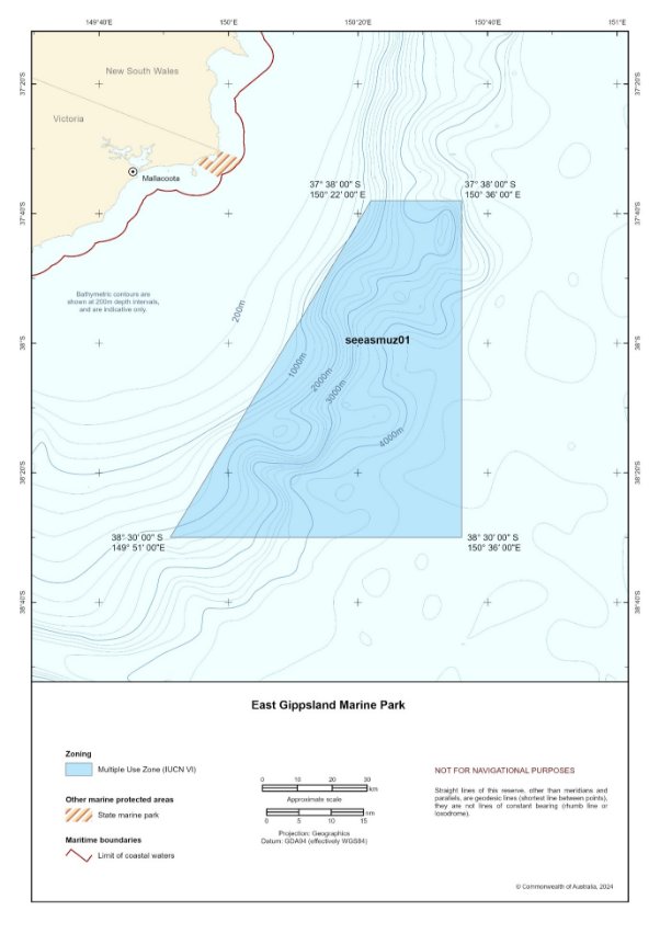
Figure S1.1 East Gippsland Marine Park
Beagle Marine Park |
Proclaimed 28 June 2007 and came into effect on 1 September 2007 |
Assigned zones in park National Park Zone (II) 479 km² Multiple Use Zone (VI) 2,448 km² |
Depth range 46 m–77 m |
Total area 2,928 km2 |
Overview and summary of values Beagle Marine Park (Figure S1.2), in Bass Strait off Wilson’s Promontory, surrounds Tasmania’s Kent Group Marine Park and the Hogan and Curtis Island groups. The seafloor of the park was part of the Ancient Land Bridge a landscape that once connected Lutruwita/Tasmania to the mainland and was used by First Nations people before it was submerged at the end of the last glacial period about 10,000 years ago. First Nations communities hold knowledge, oral traditions, stories and songlines that connect to the times of the land bridge that have been passed down through the generations, giving unique insights into the flooding of this Country. In the centre of the park, spanning much of the distance between the Kent Group and Hogan Island Group, are mesophotic (middle-light) reefs that rise 2 m to 5 m above the seabed.
They are thought to be relict coastal dunes that formed on the Ancient Land Bridge. These mesophotic reefs, which are a rare ecosystem within Bass Strait, support a sessile invertebrate assemblage comprised of bryozoans, hydroids and a high diversity of temperate sponges. Abundant and diverse fish communities are associated with these mesophotic reefs and are dominated by butterfly perch, barber perch, jackass morwong, common gurnard perch, Melbourne silverbelly, Degen’s leatherjacket, and rosy wrasse. At the time of making this plan, aggregations of many hundreds of predominantly female Port Jackson sharks have been observed in 2018 and 2024, indicating that these reef features are important for the species during winter foraging migrations to Bass Strait. Rubble fields, comprised of broken bryozoan skeletons and dead and alive scallops, occur in the centre of the park and function as reefs in the hard substrate limited environment of Bass Strait. They provide important habitat for sessile filter feeding invertebrates including bryozoans, hydroids and sponges. The shallower eastern section of the park is dominated by linear ridges less than 1 m in height that extend several kilometres. These low-profile ridges are sometimes covered by shell hash and gravel that support a diverse sessile filter feeding invertebrate community dominated by bryozoans and sponges. The deeper, south-western part of the park is sediment-dominated and contains extensive mobile dune fields less than 1 m high with patches of doughboy scallops. The park includes biologically important foraging areas for many seabirds, including 6 species of albatross (including the endangered shy albatross; the vulnerable black browed, Campbell, Indian yellow nosed and wandering albatrosses; and Bullers albatross), white faced storm petrel, common diving petrel, short-tailed shearwater and little penguin. There are also biologically important areas in the park for white shark, southern right whale and pygmy
blue whale. Humpback whales and short-tailed shearwaters (mutton birds) are culturally significant species, as their seasonal movements are in songlines and dreaming for some First Nations groups. The park contains habitats, species and ecological communities associated with the Southeast Shelf Transition provincial bioregion and the Twofold Shelf and Flinders mesoscale bioregions. The key ecological features represented in the park include: - shelf rocky reefs and hard substrate – includes mesophotic reefs between the Kent Group and Hogan Island Group.
Two historic shipwrecks occur in the park. In the north-west of the park lies the SS Queensland an iron screw steamship which sank in 1876 after colliding with another steamer while enroute from Melbourne to China. The SS Cambridge, a British cargo ship which sank on 7 November 1940 after hitting a World War II mine, lies in the north of the park in 67 m depth. Other shipwrecks may occur in the park, as 3 other ships have been lost in the vicinity of the park but are yet to be found. |
Social and economic benefits At the time of making this plan, one commercial tour operator held a licence for whale watching in the park and the main commercial fisheries operating in the park include: - South-east Scalefish and Shark Fishery gillnet, hook and trap sector (Commonwealth managed)
- Tasmanian and Victorian octopus fisheries
- Tasmanian and Victorian rock lobster fisheries
- Tasmanian Scalefish Fishery
- Victorian Ocean General Fishery
- Victorian Wrasse (Ocean) Fishery
- Victorian Commercial Permit and Small Sales Commercial Permit Fishery.
Two important commercial shipping routes to the Port of Melbourne go through the north and north-western sections of the park. |
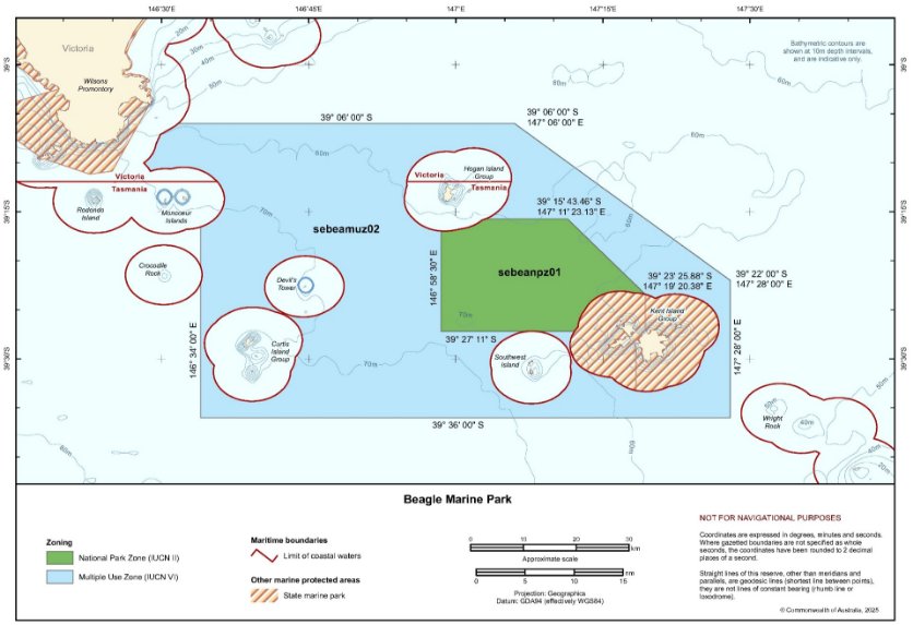
Figure S1.2 Beagle Marine Park
Flinders Marine Park |
Proclaimed 28 June 2007 and came into effect on 1 September 2007 |
Assigned zones in park National Park Zone (II) 15,024 km² Habitat Protection Zone (IV) 10,892 km² Multiple Use Zone (VI) 1,129 km² |
Depth range 34 m–5,041 m |
Total area 27,046 km2 |
Overview and summary of values Flinders Marine Park (Figure S1.3) is off the north-east tip of Tasmania near Flinders Island. The park extends from the mid-continental shelf eastwards to the outer limit of Australia’s Exclusive Economic Zone and protects a range of ecosystems, including mesophotic (middle‑light) reefs; rariphotic (rare light) reefs; shelf sediments; upper-, mid-, and lower-slope reefs and sediments; canyons; and seamounts. The seafloor of the western area of the park was part of the Ancient Land Bridge a landscape that once connected Lutruwita/Tasmania to the mainland and was used by First Nations people before it was submerged at the end of the last glacial period about 10,000 years ago. First Nations communities hold knowledge, oral traditions, stories and songlines that connect to the times of the land bridge that have been passed down through the generations, giving unique insights into the flooding of this Country. Across the park mesophotic reefs differ. In the north-west corner of the park in 40 m to 45 m depth, low-profile mesophotic reefs support a diverse benthic community of sponges, cnidarians, hydroids, gorgonian fans and soft corals. The large gorgonian fans and soft coral species have not been found elsewhere in the South-east Network. Near the centre of the western boundary mesophotic reefs are dominated by red cup sponges. Bleached red cup sponges were recorded during surveys in 2017 at this site, likely associated with a significant marine heatwave in the summer of 2015–2016 one of the few reports of bleaching in temperate sponges. On the outer shelf, in depths of 60 m to 70 m, mesophotic reefs are characterised by linear ledges that extend for kilometres or hundreds of metres long. These ledges, which are often undercut forming small caves, support a diverse sessile invertebrate community of hydrozoans, bryozoans, ascidians and sponges as well as southern rock lobsters and reef‑associated fish, including jackass morwong, velvet leatherjacket, reef ocean perch, draughtboard shark, and common gurnard perch. In contrast, between these ledges the reef is flat and sand inundated with no sessile invertebrate communities and few fish or southern rock lobster. The shelf break, in depths of about 120 m, is largely sediment draped with few reef features, although midway along the shelf break are 2 canyon incisions with exposed reef, including cliffs up to 60 m high. Fish communities associated with these features are dominated by reef ocean perch, jackass morwong and striped trumpeter. The upper slope reefs and canyons support an abundance of rare black corals and octocorals and several species of conservation-dependent deepwater sharks, including the Harrisons dogfish and southern dogfish. The park includes biologically important foraging areas for many seabirds, including 7 species of albatross (including the endangered shy albatross; the vulnerable antipodean, black browed, Campbell, Indian yellow nosed and wandering albatrosses; and Bullers albatross), white faced storm petrel, common diving petrel and short-tailed shearwater. There are also biologically important areas in the park for white shark, southern right whale and pygmy blue whale. The park contains habitats, species and ecological communities associated with 3 provincial bioregions – Southeast Transition, Southeast Shelf Transition and Tasmanian Shelf Province – and the Flinders and Freycinet mesoscale bioregions. The key ecological features represented in the park include: - shelf rocky reefs and hard substrate – includes rariphotic reefs in the north-west of the park
- east Tasmania subtropical convergence zone.
At the time of making this plan the consultation Tayaritja Milaythina Muka Indigenous Protected Area (IPA) overlaps Flinders Marine Park. This is the first Sea Country IPA consultation project in the South-east Network. It extends from north-east Lutruwita/Tasmania over the submerged land bridge and surrounds Tayaritja/Bass Strait Islands. The aim of the Tayaritja Milaythina Muka IPA consultation project is to protect culturally and ecologically important habitats and species. |
Social and economic benefits At the time of making this plan, the main commercial fisheries operating in the park include: - South-east Scalefish and Shark Fishery gillnet, hook and trap sector (Commonwealth managed)
- Tasmanian Octopus Fishery
- Tasmanian Giant Crab Fishery
- Tasmanian Rock Lobster Fishery
- Tasmanian Scalefish Fishery.
|
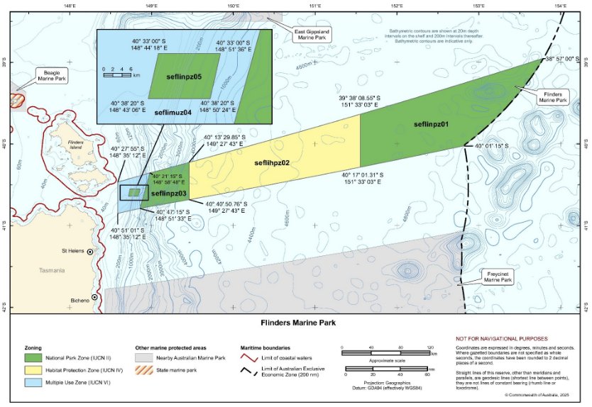
Figure S1.3 Flinders Marine Park
Freycinet Marine Park |
Proclaimed 28 June 2007 and came into effect on 1 September 2007 |
Assigned zones in park National Park Zone (II) 56,825 km² Recreational Use Zone (IV) 323 km² Habitat Protection Zone (IV) 68 km² Multiple Use Zone (VI) 725 km² |
Depth range 40 m–5,230 m |
Total area 57,941 km2 |
Overview and summary of values Freycinet Marine Park (Figure S1.4) is located east of Tasmania, 6 km–12 km offshore from the Freycinet Peninsula. It extends from the mid-continental shelf eastwards to the outer limit of Australia’s Exclusive Economic Zone. The park protects a range of ecosystems, including mesophotic (middle-light) reefs; rariphotic (rare-light) reefs; shelf sediments; upper-, mid-, and lower-slope reefs and sediments; and seamounts. Several different hard substrate features, primarily rariphotic (rare light) reef ecosystems, are present on the shelf. A highlight of the park is Joe’s Reef an isolated granite reef that rises about 20 m above the surrounding seabed near the western boundary of the park. This structurally complex reef is about 200 m by 200 m and occurs in depths of 59 m to 83 m, so the top of the reef extends into the mesophotic (middle light) rocky reef ecosystem. It is covered in a diverse invertebrate fauna of sponges, gorgonian fans, mushroom corals and rare but distinctive tree-forming black corals up to 3 m tall. Fish assemblages associated with Joe’s Reef are dominated by reef-associated species such as jackass morwong, ocean perch, butterfly perch, splendid perch, rosy wrasse and striped trumpeter. In the north-west corner of the park there are lower profile, fragmented, isolated patch reefs in depths of about 80 m. Fish assemblages associated with these patch reefs are dominated by jackass morwong, barred grubfish, ocean perch and common gurnard perch. There are several small, distinct areas of reef on the shelf-break, likely scoured of sand cover by currents associated with adjacent canyons. They are steep mudstone ledge/cliffs without significant reef complexity. Fish assemblages associated with these features include relatively high abundances of jackass morwong, ocean perch and striped trumpeter. Sawtail catshark have also been observed at these shelf break reefs. Between 70 m80 m and 120 m200 m the habitat is primarily soft sediment. Fish assemblages in these habitats are dominated by flathead and barred grubfish. Toothy flathead is the most common flathead species and is widely distributed across the shelf. Tiger flathead is found across the shelf to the shelf breaks but predominantly in the Multiple Use Zone and in lower numbers. Sand flathead is found in shallower shelf sites in the Multiple Use Zone. Much of the shelf between 80 m and 120 m is covered by low-profile dune-like ridge features that are orientated in a northsouth direction parallel to the coast and extend 3 km to 5 km. They are likely consolidated relic glacial coastal dune features drowned by sea level rise following the last glacial period. These systems are intermediate between reef and soft sediment. Despite being consolidated they rarely have hard-rock outcropping and are typically covered in a fine layer of sand or silt with emergent small sponges and bryozoan/hydroid turf matrix. Fish assemblages include jackass morwong, common gurnard perch, spikey dogfish, gummy shark and draughtboard shark. The park includes biologically important seabird foraging areas for 7 species of albatross (including the endangered shy albatross; the vulnerable antipodean, black browed, Campbell, Indian yellow nosed and wandering albatrosses; and Bullers albatross), white faced storm petrel, common diving petrel, soft plumaged petrel, and short-tailed shearwater. There are also biologically important areas in the park for vulnerable white shark and endangered southern right and pygmy blue whales. The park contains habitats, species, and ecological communities associated with 3 provincial bioregions – Tasmania Province, Tasmanian Shelf Province, and Southeast Transition – and the Freycinet mesoscale bioregion. The key ecological features represented in the park include: - shelf rocky reefs and hard substrate – includes rariphotic reefs in the north-west of the park
- seamounts, east and south of Tasmania
- east Tasmania subtropical convergence zone.
|
Social and economic benefits At the time of making this plan, the main commercial fisheries operating in the park include: - South-east Scalefish and Shark Fishery gillnet, hook and trap sector (Commonwealth managed)
- Tasmanian Scalefish Fishery
- Tasmanian Octopus Fishery
- Tasmanian Giant Crab Fishery
- Tasmanian Rock Lobster Fishery.
This park is one of the parks in the South-east Network most used by recreational fishers due to its proximity to the coastal town of Bicheno, but use is low relative to state waters nearer shore. Recreational fishing is focused on the shelf, shelf break and upper slope areas of the park. The spectacular Joe’s Reef is occasionally dived by deepwater technical recreational
scuba divers. |

Figure S1.4 Freycinet Marine Park
Huon Marine Park |
Proclaimed 28 June 2007 and came into effect on 1 September 2007. Incorporated the entire Tasmanian Seamounts Marine Reserve proclaimed on19 May 1999. |
Assigned zones in park National Park Zone (II) 1,433 km² Multiple Use Zone (VI) 8,558 km² |
Depth range 50 m–4,040 m |
Total area 9,991 km² |
Overview and summary of values Huon Marine Park (Figure S1.5) lies south-east of Tasmania and extends from the outer limit of state coastal waters to abyssal depths over 4,000 m. It protects a range of ecosystems, including mesophotic (middle-light) reefs; rariphotic (rare-light) reefs; shelf sediments; upper-, mid-, and lower-slope reefs and sediments; and Australia’s largest known cluster of seamounts. The area is dominated by cool sub-Antarctic waters in winter but by subtropical waters in summer, when the East Australian Current extends further south. In the north-east of the park in depths of 35 m to 100 m are medium- to high-profile mesophotic (middle-light) and rariphotic (rare-light) reefs, which provide habitat for rock lobster. The shallowest parts of the reef support small patches of golden kelp with an understory of red algae. The deeper areas of the reef support an extensive low-profile sessile invertebrate matrix and soft bryozoans, gorgonian and bramble corals, sea whips, colonial anemones and a diverse range of sponges. The fish community is dominated by butterfly perch, cosmopolitan leather jacket, splendid perch, jackass morwong, morid cod species, ocean perch, rosy wrasse, striped trumpeter and draughtboard shark. Handfish have been recorded in the park. Species identifications are yet to be confirmed but appear to include the vulnerable Ziebell’s handfish and the pink handfish and potentially other species, some of which may be undescribed species new to science. Approximately 150 seamounts (undersea ancient volcanoes) occur in the park. They rise several hundred metres above the seafloor, with their summits reaching between 600 m and 2,400 m below the sea surface. Benthic communities are dominated by fragile, slow-growing deep-sea coral communities on seamounts shallower than 1,350 m and by urchins in deeper waters. The deep-sea coral communities, globally recognised for their diversity, include stony reef building corals and octocorals, which provide habitat for a variety of other species. Some of the deep-sea coral communities were damaged by deep-sea bottom trawling for orange roughy in the 1990s. Patience seamount provides spawning grounds for basketwork eels the only reported spawning aggregation of oceanic eels globally. Basketwork eels are scavengers and important species for nutrient cycling and ecosystem function. The park includes biologically important foraging areas for many seabirds, including 7 species of albatross (including the antipodean, black browed, Bullers, Campbell, Indian yellow nosed, shy and wandering albatrosses), sooty and short-tailed shearwaters, soft plumaged petrels, common diving petrel and Australasian gannet. There are also biologically important areas in the park for white shark, southern right whale and pygmy blue whale. The park contains habitats, species, and ecological communities associated with 2 provincial bioregions – Tasmanian Shelf Province and Tasmania Province and the Bruny and Davey mesoscale bioregions. The key ecological features represented in the park include: - shelf rocky reefs and hard substrate – includes the rariphotic reefs in the north of the park
- seamounts, east and south of Tasmania
- east Tasmania subtropical convergence zone.
The Tasmanian Seamounts Commonwealth Heritage Area lies within the Huon Marine Park. The seamounts were listed because they support a deep-sea benthic community characterised by high biodiversity and endemism, and long-lived, slow-growing species vulnerable to disturbance. |
Social and economic benefits At the time of making this plan, the main commercial fisheries operating in the park include: - South-east Scalefish and Shark Fishery gillnet, hook and trap sector (Commonwealth managed)
- Eastern Tuna and Billfish Fishery (Commonwealth managed)
- Southern Bluefin Tuna Fishery (Commonwealth managed)
- Tasmanian Rock Lobster Fishery
- Tasmanian Giant Crab Fishery
- Tasmanian Scalefish Fishery.
The recreational fishing hotspot for southern bluefin tuna near Pedra Branca may extend into the park. |

Figure S1.5 Huon Marine Park
South Tasman Rise Marine Park |
Proclaimed 28 June 2007 and came into effect on 1 September 2007 |
Assigned zones in park National Park Zone (II) 27,704 km² |
Depth range 804 m–5,022 m |
Total area 27,704 km² |
Overview and summary of values The remote South Tasman Rise Marine Park (Figure S1.6) is about 240 km south-east of Tasmania and extends to the outer limit of Australia’s Exclusive Economic Zone about 370 km from land. The South Tasman Rise Marine Park protects mid-slope, lower-slope, abyssal and seamount ecosystems. The western section of the park includes a large, submerged plateau of continental rock believed to be the last remnant of the link between Australia and Antarctica, when the Australian continent moved north around 100 million years ago. This plateau includes the largest area of mid-slope ecosystem in the South-east Network. Deep-sea coral communities may occur on the shallower parts of this plateau, as they have been found in similar habitats just south of the park. The eastern section of the park contains several guyots, flat-topped seamounts, rising about 2,300 m above the seafloor. The flat tops are evidence they were once above the ocean’s surface, where they were shaped by wind and wave erosion. The guyot tops are now about 2,000 m to 2,300 m below the sea surface – which is likely too deep to support live deep-sea coral communities. In the Tasman Fracture and Huon Marine Parks live deep-sea coral communities are not found deeper than about 1,350 m. The park contains habitats, species and ecological communities associated with the Tasmania Province provincial bioregion. The key ecological features represented in the park include: - seamounts, east and south of Tasmania.
|
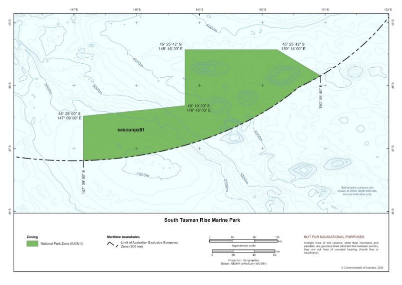
Figure S1.6 South Tasman Rise Marine Park
Tasman Fracture Marine Park |
Proclaimed 28 June 2007 and came into effect on 1 September 2007 |
Assigned zones in park National Park Zone (II) 22,536 km² Multiple Use Zone (VI) 19,965 km² |
Depth range 60 m – 5,559 m |
Total area 42,501 km² |
Overview and summary of values Tasman Fracture Marine Park (Figure S1.7), off south-west Tasmania, extends from the outer limit of state coastal waters southwards to the outer limit of Australia’s Exclusive Economic Zone. It protects a wide range of ecosystems, including rariphotic (rare-light) reefs; shelf sediments; upper, mid, and lower slope reefs and sediments; seamount reefs and sediments; and abyssal plains. It is an area of high productivity due to a combination of ocean currents and upwelling from nearby canyons. Several small high-profile rariphotic reefs occur in the park mainly in depths of 100 m to 140 m. They are covered by a diverse sessile invertebrate community, which differs from other rariphotic reefs in the network in having a high abundance of soft corals. These reefs support a fish community dominated by splendid perch, butterfly perch, ocean perch, rosy wrasse, morid cod species, draughtboard shark, jackass morwong and striped trumpeter. They also provide important habitat for rock lobster a keystone species that plays an important role in reef systems and is an important commercial species. Handfish have been recorded in the park in depths between 92 m and 145 m. Species identifications are yet to be confirmed but likely include the pink handfish, vulnerable Ziebell’s handfish, warty handfish and the Australian handfish. At the time of the first sighting of pink handfish in 2021, this species had not been seen in the wild for over 22 years. A collar seahorse has also been recorded from the park. This is only the third ever sighting of this species globally – the other sightings being in Lord Howe Island and New Zealand. The small cluster of seamounts in the park are part of the key ecological feature seamounts south and east of Tasmania. Their peaks reach between 635 m and about 1,500 m below the sea surface. Seamounts shallower than 1,350 m support fragile deep-sea coral communities. A large fish aggregation occurs on Main Matt seamount – dominant species include orange roughy, oreo dories and a diverse range of deep-sea sharks (including Plunkets dogfish, longnose velvet dogfish, freckled catshark and several species of lantern shark). An egg case nursery of the boreal skate occurs on seamount Z110, with egg cases typically found on living stony coral Solenosmilia variabilis in depths between 950 m and 1,350 m. The largest breeding colony of the Tasmanian endemic endangered shy albatross is at Mewstone an uninhabited offshore island that is surrounded by the Tasman Fracture
Marine Park. The shelf area of the park provides foraging grounds for shy albatross from the Mewstone colony and post-fledgling shy albatross from the breeding colony at Albatross Island. The park also includes biologically important foraging areas for 6 other species of albatross (including the antipodean, black browed, Bullers, Campbell, Indian yellow nosed, and wandering albatrosses), sooty and short-tailed shearwaters, soft plumaged petrels, common diving petrel and Australasian gannet. There are also biologically important areas for white shark, southern right whale and pygmy blue whale. Fur seals also feed in the park. The park contains habitats, species, and ecological communities associated with 3 provincial bioregions the West Tasmania Transition, Tasmania Province and Tasmanian Shelf Province and the Davey mesoscale bioregion. The key ecological features represented in the park include: - shelf rocky reefs and hard substrate – includes the rariphotic reefs in the north of the park
- seamounts, east and south of Tasmania
- west Tasmanian canyons.
|
Social and economic benefits At the time of making this plan, the main commercial fisheries operating in the park include: - South-east Scalefish and Shark Fishery gillnet, hook and trap sector (Commonwealth managed)
- Eastern Tuna and Billfish Fishery (Commonwealth managed)
- Tasmanian Rock Lobster Fishery
- Tasmanian Giant Crab Fishery
- Tasmanian Scalefish Fishery.
|
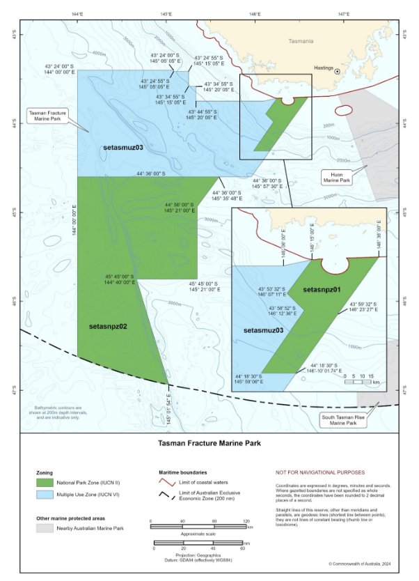
Figure S1.7 Tasman Fracture Marine Park
Zeehan Marine Park |
Proclaimed 28 June 2007 and came into effect on 1 September 2007 |
Assigned zones in park National Park Zone (II) 18,663 km² Special Purpose Zone (VI) 301 km² Multiple Use Zone (VI) 933 km² |
Depth range 91 m–5,174 m |
Total area 19,897 km² |
Overview and summary of values Zeehan Marine Park (Figure S1.8), off north-west Tasmania, lies in a high wave energy area. The park protects shelf unvegetated sediments; rariphotic (rare-light) reefs; canyons; upper, mid and lower slope reefs and sediments; and abyssal plain ecosystems. On the continental shelf, the eastern third of the park is dominated by bare rippled sand. The middle third has flat pavement rariphotic rocky reef with step features several kilometres long and is characterised by a distinct community of fan worms and hard bryozoans. In the western third the reef is fractured into distinctly elevated blocks up to 5 m high and covered in bryozoan turf and thicket interspersed with large sponges, sea whips and large hard bryozoans. The shelf-edge communities are characterised by a low relief turf and thicket (up to 200 mm high) of bryozoans, sponges and ascidians (sea squirts) that provide habitat for a variety of other fauna, including corals, hydroids, crustaceans, sea stars, brittle stars, molluscs and fish. Elongate rocky terraces on the upper slope (200 m–700 m) provide rare rocky habitat on the mud-draped slope landscape of western Tasmania. They provide habitat for diverse sessile fauna and associated mobile fauna, including giant crabs. It is one of the few upper-slope areas in the western part of the south-east marine region that has not been trawled. The park contains 5 canyons that extend from the shelf edge to the abyssal plain – part of the West Tasmanian canyons key ecological feature. They are predominantly mud-filled, but the rocky outcrops that occur support a highly diverse sponge community and associated fauna. The biodiversity and productivity in the park are influenced by the southward-flowing Zeehan Current (an extension of the Leeuwin Current from Western Australia) interacting with the canyons. Zeehan Marine Park provides core foraging areas for early incubating endangered Tasmanian endemic shy albatross from Albatross Island. The park also includes biologically important foraging areas for 6 other species of albatross (including the antipodean, black browed, Bullers, Campbell, Indian yellow nosed, and wandering albatrosses), wedge-tailed and short‑tailed shearwaters and common diving petrel. There are also biologically important areas in the park for white shark, southern right whale and pygmy blue whale. The park contains habitats, species, and ecological communities associated with 3 provincial bioregions the West Tasmania Transition, the Western Bass Strait Shelf Transition, and the Tasmania Province – and the Otway mesoscale bioregion. The key ecological features represented in the park include: - west Tasmanian canyons
- shelf rocky reefs and hard substrate – includes the rariphotic reefs on the mid and outer shelf.
|
Social and economic benefits At the time of making this plan, the main commercial fisheries operating in the park include: - Tasmanian Rock Lobster Fishery
- Tasmanian Giant Crab Fishery.
Zeehan Marine Park lies in the Otway Basin a highly prospective natural gas reserve. Six existing petroleum titles (exploration permits at the commencement of this plan) overlap the northern section of the park. |
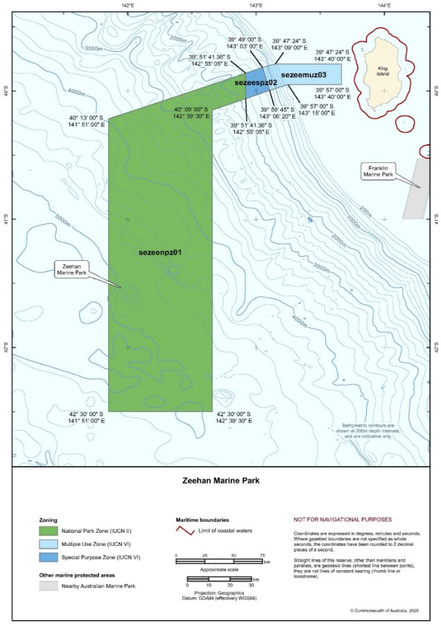
Figure S1.8 Zeehan Marine Park
Franklin Marine Park |
Proclaimed 28 June 2007 and came into effect on 1 September 2007 |
Assigned zones in park National Park Zone (II) 123 km² Multiple Use Zone (VI) 548 km² |
Depth range 49 m–116 m |
Total area 671 km² |
Overview and summary of values Franklin Marine Park (Figure S1.9) is west of the north-western corner of Tasmania. The area is subject to large swells driven by westerly winds. The north-east corner of the park contains a complex mesophotic (middle-light) reef likely formed by volcanic lava flows. At its shallowest depths of 35 m, Ecklonia radiata kelp forests occur – a habitat only found in 2 parks within the South-east Network. The deeper parts of this reef are covered in red macroalgae, sponges, gorgonians, hard bryozoans and tube worms. Another area of mesophotic reef occurs midway along the eastern boundary of the park, but at the time of making this plan its extent is unknown, as the area is not fully mapped. Patchy mesophotic and rariphotic (rare-light) reef habitats occur in the northern section of the park, to the west and south of the complex volcanic reef. These are also covered in brown and red macroalgae, gorgonians and sponges but have lower diversity than the complex mesophotic reefs. The southern end of the park contains low-profile rariphotic reefs in depths of about 80 m to 90 m. These are likely limestone pavement and are often sand inundated except at step features which support a diverse sponge community. The park is a core foraging area for early incubating Tasmanian endemic endangered shy albatross from the nearby Albatross Island breeding colony. It also includes biologically important foraging areas for 6 other species of albatross (including the vulnerable antipodean, black browed, Campbell, Indian yellow nosed and wandering albatrosses, and Bullers albatross), white faced storm petrel, common diving petrel, little penguin, Australasian gannet, and short-tailed shearwater. Biologically important areas for white shark, southern right whale and pygmy blue whale also occur in the park. The park contains habitats, species, and ecological communities associated with 2 provincial bioregions Tasmanian Shelf Province and Western Bass Shelf Province – and the Otway and Franklin mesoscale bioregions. The key ecological features represented in the park include: - shelf rocky reefs and hard substrate – includes the mesophotic and rariphotic reefs in the north, east and south sections of the park.
|
Social and economic benefits At the time of making this plan, the main commercial fisheries operating in the park include: - South-east Scalefish and Shark Fishery gillnet, hook and trap sector (Commonwealth managed)
- Tasmanian Octopus Fishery
- Tasmanian Rock Lobster Fishery
- Tasmanian Giant Crab Fishery
- Tasmanian Scalefish Fishery.
|
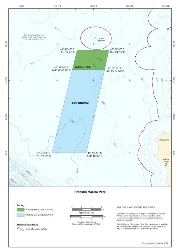
Figure S1.9 Franklin Marine Park
Boags Marine Park |
Proclaimed 28 June 2007 and came into effect on 1 September 2007 |
Assigned zones in park Multiple Use Zone (VI) 537 km² |
Depth range 10 m–62 m |
Total area 537 km² |
Overview and summary of values Boags Marine Park (Figure S1.10) is off the north-west tip of Tasmania, north of Three Hummock Island. The marine park represents an area of shallow ecosystems contained
within western Bass Strait. The park is dominated by extensive, mobile dune fields caused by the combination of shallow depths and strong tidal currents. Some of the dunes are over
10 m high. The mobile dunes are unlikely to support complex sessile invertebrate communities and are more likely dominated by crustaceans, polychaete worms and molluscs that live on and in sediments. The area is known to support relatively large populations of pale octopus. The seafloor of the park was part of the Ancient Land Bridge a landscape that once connected Lutruwita/Tasmania to the mainland and was used by First Nations people before
it was submerged at the end of the last glacial period about 10,000 years ago. First Nations communities hold knowledge, oral traditions, stories and songlines that connect to the times of the land bridge that have been passed down through the generations, giving unique insights into the flooding of this Country. The park is a core foraging area for juvenile Tasmanian endemic endangered shy albatross from the nearby Albatross Island breeding colony. It also includes biologically important foraging areas for many seabirds, including 5 other species of albatross (including the vulnerable black browed, Campbell, Indian yellow nosed and wandering albatrosses, and Bullers albatross), white faced storm petrel, common diving petrel, little penguin and the culturally significant short-tailed shearwater (mutton birds). Biologically important areas for white shark, southern right whale and pygmy blue whale also occur in the park. The park contains habitats, species and ecological communities associated with one provincial bioregion – the Bass Strait Shelf Province – and Central Bass Strait and Boags mesoscale bioregions. |
Social and economic benefits At the time of making this plan, the main commercial fisheries operating in the park include: - South-east Scalefish and Shark Fishery gillnet, hook and trap sector (Commonwealth managed)
- Tasmanian Octopus Fishery
- Tasmanian Scalefish Fishery.
|
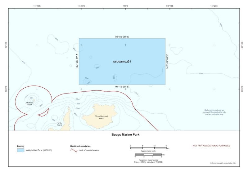
Figure S1.10 Boags Marine Park
Apollo Marine Park |
Proclaimed 28 June 2007 and came into effect on 1 September 2007 |
Assigned zones in park Multiple Use Zone (VI) 1184 km2 |
Depth range 47 m–101 m |
Total area 1,184 km2 |
Overview and summary of values The Apollo Marine Park (Figure S1.11) is located at the western entrance to Bass Strait about 6 km south of Cape Otway. The area is subject to large south-westerly swells and strong tidal flows, and wind-driven upwelling sometimes occurs during summer. The park protects several ecosystems on the continental shelf, including mesophotic (middle-light) and rariphotic (rare‑light) reefs and sediments. An area of mesophotic reef approximately 11 km2 occurs in the north-west corner of the park in depths between 47 m and 70 m. The deepest edge of the reef is likely to be a paleo‑shoreline. The reef supports benthic communities dominated by sponges, with some octocorals, bryozoans and encrusting macroalgae. Fish communities are dominated by velvet leatherjackets, six spine leatherjackets, jackass morwong, rosy wrasse, butterfly perch, bluethroat wrasse and gummy shark. The reef provides habitat for southern rock lobsters an apex predator important for ecosystem function. They are more abundant at deeper mesophotic depths than the shallowest areas of the reef. In depths of 70 m to 80 m, a ridge of low-profile rariphotic (rare-light) reef runs parallel to the paleo-shoreline separated by a 3 km wide sand dominated trough. The benthic community is largely sparse, erect sponges and occasional octocorals. Fish communities are dominated by velvet leatherjackets, Degen’s leatherjackets, pink snapper and gummy shark. In the south-east section of the park, mapping shows distinct ledge features in depths of
about 80 m to 90 m. These are likely to be rariphotic reef habitats, but ground truthing surveys are required to confirm this and the composition of the benthic fauna associated with these features. Sediment habitats comprised of fine and coarse sand are a dominant feature of the park, particularly in depths below 75 m. In the north of the park there are several sand waves that
lie eastwest. Fish communities are dominated by common gurnard perch, barracouta, sand flathead, draughtboard shark and spikey dogfish. The northern section of the park may be a nursery for spikey dogfish, as only juvenile and sub-adults were detected in surveys. The park includes biologically important foraging areas for several seabirds, including 7 species of albatross (including the endangered shy albatross; the vulnerable black browed, Campbell, Indian yellow nosed and wandering albatrosses; and the Bullers albatross), common diving petrel and the culturally significant wedge-tailed and short-tailed shearwaters. There are also biologically important areas in the park for the vulnerable white shark and endangered southern right and pygmy blue whales. The park contains habitats, species and ecological communities associated with the 2 provincial bioregions – Western Bass Strait Shelf Transition and Bass Strait Shelf Province – and the Central Bass Strait mesoscale bioregion. The key ecological features represented in the park include: - shelf rocky reefs and hard substrate – includes the mesophotic and rariphotic reefs in the north-west corner of the park.
The MV City of Rayville shipwreck, an American freighter, lies near the western boundary of the park in a depth of 80 m. It was the first American vessel sunk during World War II – on 8 November 1940 after hitting a mine. |
Social and economic benefits At the time of making this plan, the main commercial fisheries operating in the park include: - South-east Scalefish and Shark Fishery gillnet, hook and trap sector (Commonwealth managed)
- Southern Bluefin Tuna Fishery (Commonwealth managed)
- Victorian Rock Lobster Fishery
- Victorian Ocean General Fishery
- Victorian Wrasse (Ocean) Fishery
- Victorian Commercial Permit and Small Sales Commercial Permit Fishery.
Moderate-use commercial shipping routes into and out of Melbourne extend over most
of the park. |
 Figure S1.11 Apollo Marine Park
Nelson Marine Park |
Proclaimed 28 June 2007 and came into effect on 1 September 2007. |
Assigned zones in park National Park Zone (II) 6,123 km² |
Depth range 2,557 m–5,612 m |
Total area 6,123 km2 |
Overview and summary of values Nelson Marine Park (Figure S1.12) lies 200 km off the coast of eastern South Australia. It protects primarily abyssal ecosystems and an area of lower slope dissected by canyon features in the northern section of the park. Little is known about the benthic habitat and biodiversity in Nelson Marine Park, as no benthic surveys have been undertaken in this very remote and very deep park. Based on surveys undertaken in the Great Australian Bight and off south-eastern Australia, it appears that the composition of faunas associated with lower slope and abyssal ecosystems change over scales of 12,000 km. The faunas in the Great Australian Bight are compositionally distinct from those off both south-eastern and north-eastern Australia. Surveys will be required to determine if the faunas in Nelson Marine Park are compositionally similar to those in the Great Australian Bight or off south-eastern Australia, or whether they are compositionally distinct. Many whales migrate through the park when travelling between the cold food-filled southern waters and the warmer waters north where they breed. The park contains habitats, species and ecological communities associated with the West Tasmanian Transition provincial bioregion. |

Figure S1.12 Nelson Marine Park
Murray Marine Park |
Proclaimed 28 June 2007 and came into effect on 1 September 2007 |
Assigned zones in park National Park Zone (II) 17,168 km² Habitat Protection Zone (IV) 3,678 km² Multiple Use Zone (VI) 4,957 km² |
Depth range 24 m–5,729 m |
Total area 25,804 km2 |
Overview and summary of values Murray Marine Park (Figure S1.13) is south of Kangaroo Island, South Australia. It extends from state coastal waters adjacent to South Australia’s Encounter Marine Park to the outer boundary of Australian waters. It protects a wide range of ecosystems, including rariphotic (rare-light) reefs; shelf sediments; canyons; upper-, mid-, and lower-slope reefs and sediments; and abyssal plains. Most of the shelf area of the park appears to be sediment. Towards the shelf break there are rariphotic reefs that are largely sand inundated but support a sessile invertebrate community dominated by soft corals. The shelf is a core foraging area for post-fledgling Tasmanian endemic endangered shy albatross from Albatross Island, western Bass Strait. The northern section of the park is a breeding area for endangered southern right whales and a foraging area for male endangered Australian sea lions. The park includes several canyons that are part of the Murray Canyons group, including west Sprigg Canyon, east Sprigg Canyon, Seal Canyon, Kangaroo Canyon and Gantheaume Canyon. West Sprigg Canyon, the deepest and one of the largest, is about 60 km long, 30 km wide and 2 km deep. Upwelling of nutrient-rich waters occurs in this area, which is a feeding and nursing aggregation area for endangered pygmy blue whales and likely a sperm whale feeding area. The park contains habitats, species and ecological communities associated with 3 provincial bioregions – Spencer Gulf Shelf Province, Southern Province and West Tasmania Transition – and the Coorong mesoscale bioregion. |
Social and economic benefits At the time of making this plan, the main commercial fisheries operating in the park include: - South-east Scalefish and Shark Fishery gillnet, hook and trap sector (Commonwealth managed)
- Southern Bluefin Tuna Fishery (Commonwealth managed)
- Small Pelagic Fishery (Commonwealth managed)
- South Australian Sardine Fishery
- South Australian Rock Lobster Fisheries
- South Australian Marine Scalefish Fishery
- South Australian Giant Crab Fishery.
This park is one of the parks in the South-east Network most used by recreational fishers due to its proximity to the coastal town of Victor Harbour, but use is low relative to state waters nearer shore. Recreational fishing is focused in the nearshore northern section of the park. |
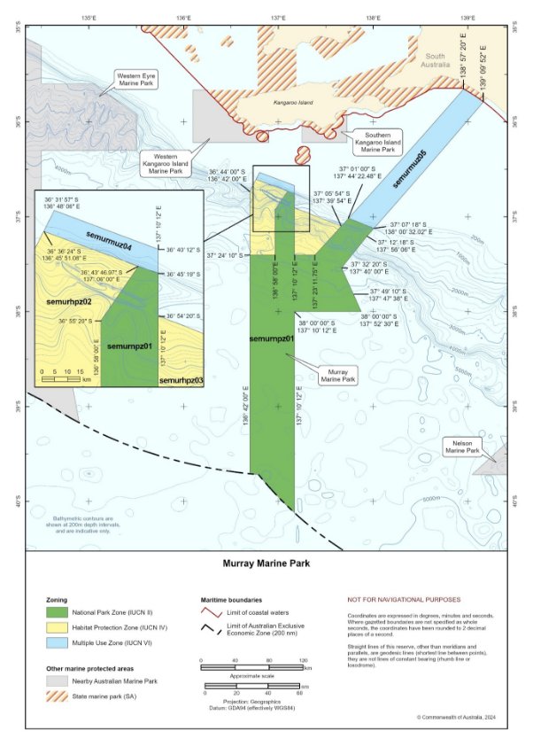
Figure S1.13 Murray Marine Park
Macquarie Island Marine Park |
Proclaimed 20 October 1999 and expanded 1 July 2023 |
Assigned zones in park Sanctuary Zone (IUCN Ia) 57,137 km² National Park Zone (IUCN II) 385,133 km² Habitat Protection Zone (Macquarie) (IUCN IV) 33,196 km² |
Depth range 86 m–6,341 m |
Total area 475,465 km² |
Overview and summary of values Macquarie Island Marine Park (Figure S1.14) is in the Southern Ocean, 1,500 km south-east of Tasmania and approximately halfway between Australia and Antarctica. A dominant feature of the park is the Macquarie Ridge, which runs northsouth through the middle of the park. This oceanic ridge, the boundary between the Indo-Australian Plate and the Pacific Plate, impedes the eastward flow of the Antarctic Circumpolar Current, creating significantly different oceanic conditions and biology on the west and east sides of the ridge. From north to south there are 3 distinct bodies of water separated by 2 major oceanographic fronts (boundaries between distinct water masses) which run eastwest through the park.
The Sub-Antarctic Zone, with water temperatures greater than 8°C, is north of the Subantarctic Front. The Polar Frontal Zone, with water temperatures between 5.5°C and 8°C, lies between the 2 fronts. The Antarctic Zone, with water temperatures less than 5.5°C, is south of the
Polar Front. The Subantarctic Front is the transition between calcareous phytoplankton to the north and siliceous phytoplankton to the south. The area between the fronts has high nutrients but low phytoplankton productivity due to limited availability of iron. Macquarie Island and ridge provide a source of iron, so productivity is elevated downstream, to the north-east
of the island. The park contains habitats, species and ecological communities associated with one provincial bioregion – Macquarie Province. This bioregion is characterised by sub-Antarctic organisms and is very distinct from other bioregions in the south-east region. The limited sampling and research of the benthic habitats has been focused on Macquarie Ridge and the seamounts. The benthic fauna on the ridge tends to be separated into 3 groups: the northern section (4852°S) is a New Zealand subantarctic fauna, the southern section (5557°S) is an Antarctic fauna, and the central section (5354°S) is a mixed zone with a few endemic species. Along the Macquarie Ridge, the habitat-forming benthic fauna of stony corals and gorgonians mainly occur on the tops of the ridge north and south of Macquarie Island. These areas also have a higher diversity of sponges, crustaceans and echinoderms than areas to the east and west of Macquarie Island. The slopes of the Macquarie Ridge are very steep with rubble fields and tend to have low levels of biodiversity, likely due to their instability. However, overhangs and ledges provide habitats for sponges, gorgonian corals, hydrocorals and anemones. In depths of 200 m to 500 m east and west of Macquarie Island, the fauna is dominated by brachiopods, solitary ascidians and bivalve molluscs. The more sheltered eastern side of the island also has sediment-related fauna, such as sea pens. The bottoms of canyons and troughs are typically sediment dominated, with minimal habitat forming invertebrates. The peaks of the 5 seamounts surveyed are in depths between about 90 m and 750 m below the sea surface. Each of the seamounts has different faunal assemblages. Fauna on the seamounts include gorgonian corals, bubblegum corals, hydrocorals, stony corals, black corals, sponges, anemones, bryozoans, sea stars, brittle stars, sea cucumbers and crabs. Based on the limited animal tracking data available at the time of making the plan, several seabird species that breed on Macquarie Island during the summer likely forage in the Macquarie Island Marine Park. The vulnerable black-browed albatross tend to forage in the parts of the park closest to Macquarie Island or travel further offshore through the north‑eastern sector of the park. The vulnerable wandering albatrosses tend to predominantly use the northern sector of the park. The endangered grey-headed albatrosses tend to use areas due east of the island to the outer boundary of Australia’s Exclusive Economic Zone and light-mantled sooty albatrosses tend to use the south-western sector of the park. Royal penguins, which are endemic to Macquarie Island, and king penguins both tend to forage in and transit through the south-eastern sector of the park. Grey petrels, which breed during winter, tend to forage and transit through the northern sector of the park, particularly in the ridge area north of the island. Seals breeding on Macquarie Island also utilise the marine park. During the summer breeding season, Antarctic fur seals tend to forage around the islands and in an area within about 200 km to the north-east of the islands. During the spring/early summer breeding season, adult vulnerable southern elephant seals transit through most areas of the park on their way to their main foraging grounds outside the park. However, during the moulting season, in January to March, they tend to use the southern sector of the park. Humpback whales and endangered southern right whales have been recorded migrating through the marine park during November to December and winter, respectively. Parts of Macquarie Island Marine Park, from the inshore boundary out to about 16.7 km (the edge of the territorial seas), intersect with the Macquarie Island World Heritage Area, which was listed for its outstanding geological values and wild natural beauty, including large aggregations of king penguins, elephant seals and royal penguins – a species endemic to Macquarie Island and the nearby Bishop and Clerk Islets. This area is also on the National Heritage List.
The shipwreck of Nella Dan, a 75 m supply and research ship used by Australia’s Antarctic research program between 1961 and 1987, lies at 5,000 m depth within the Sanctuary Zone. |
Social and economic benefits At the time of making this plan, the only commercial fishery operating in the park is the Macquarie Island Toothfish Fishery a sustainable demersal longline fishery for Patagonian toothfish. The fishery has been operating since 1994, initially as a trawl fishery, but it has only used longline since 2010. Only 2 companies have a right of access to the fishery. At the time of making this plan, the fishery is certified by the international Marine Stewardship Council. |
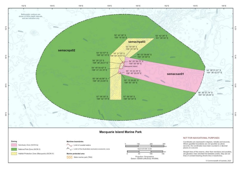
Figure S1.14 Macquarie Island Marine Park
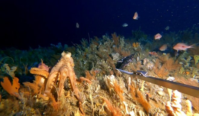
Image: An octopus explores an expansive coral bed in Tasman Fracture Marine Park (Institute for Marine and Antarctic Studies)
S2.1 The EPBC Act and EPBC Regulations
At the commencement of this plan, the Australian Government is implementing its commitment to reforming Australia’s environmental laws as set out under the Nature Positive Plan: better for the environment, better for business (Nature Positive Plan). The Nature Positive Plan will involve amendments to the Environment Protection and Biodiversity Conservation Act 1999 (Cth) (EPBC Act), and we acknowledge these amendments may impact the provisions in this schedule.
At the commencement of this plan, the EPBC Act is Australia’s primary environmental legislation.
S2.1.1 Commonwealth reserves
Commonwealth reserves are areas of land or sea that:
- the Commonwealth owns or leases
- are in a Commonwealth marine area, or
- are outside Australia, that the Commonwealth has international obligations to protect,
and which are proclaimed by the Governor-General to be a Commonwealth reserve under section 344 of the EPBC Act.
A proclamation must assign the Commonwealth reserve to an International Union for the Conservation of Nature (IUCN) category and may also divide the reserve into zones and assign each zone to an IUCN category (section 340(1)(2) and (2), EPBC Act).
For the purposes of this plan, all 14 marine parks in the South-east Marine Parks Network (South-east Network) are Commonwealth reserves proclaimed over an area of sea under section 344 of the EPBC Act.
Commonwealth marine areas are a Matter of National Environment Significance and are also subject to the environment assessment and approval process outlined in Section 2.1.5 (Environmental assessment and approval).
The environment of the Commonwealth marine area is considered a Matter of National Environmental Significance and is protected by Part 3 of the EPBC Act.
The Director of National Parks (Director) holds any usage rights that relate to land or seabed in the Commonwealth reserve (section 345A, EPBC Act) and is responsible for the administration and management of Commonwealth reserves under Division 5 of Part 19 of the EPBC Act.
S2.1.2 Management plans
Under section 366 of the EPBC Act, the Director must prepare a management plan for each Commonwealth reserve in accordance with EPBC Act, which must be approved by the Minister under section 370 of the EPBC Act.
Under section 362 of the EPBC Act:
- the Director must manage a Commonwealth reserve to give effect to a management plan for the reserve, and
- Commonwealth agencies must act so as not to contravene a management plan.
Additionally, a management plan may limit or prohibit the exercise of a power of function under the EPBC Act or Environment Protection and Biodiversity Conservation Regulations 2000 (EPBC Regulations) (section 362(3), EPBC Act).
A management plan is a ‘legislative instrument’ for the purposes of the Legislation Act 2003 (Cth) (formerly the Legislative Instruments Act 2003).
S2.1.3 Control of actions in Commonwealth reserves
The EPBC Act and EPBC Regulations prohibit a range of actions being taken in Commonwealth reserves except where the actions are taken in accordance with a management plan in operation for the Commonwealth reserve.
These prohibited actions include those actions in:
- sections 354355A of the EPBC Act
- Division 12 of the EPBC Regulations.
The prohibited activities in Division 12 of the EPBC Regulations also do not apply if carried out in accordance with the exceptions provided in regulation 12.06(1), including where the activity:
- is carried out by:
- the Director, and wardens or rangers appointed under the EPBC Act (para (b)),
- a Commonwealth agency, or
- an agency of a state or self-governing territory and is reasonably necessary for law enforcement (para (j))
- is authorised by a permit issued by the Director under Part 17 of the EPBC Regulations (para (c))
- is carried out by an Indigenous person under paragraphs (d) or (e)
- is approved under Part 9 for certain actions in Commonwealth marine areas and Commonwealth land (para (f))
- is in a class of actions declared by the Minister not to require approval in Commonwealth marine areas and Commonwealth land and is taken in accordance with an accredited management plan for the purposes of that declaration (para (g))
- is carried out in accordance with a wildlife conservation plan, a recovery plan or a threat abatement plan in force under Division 5 of Part 13 of the EPBC Act (para (h))
- is reasonably necessary to deal with an emergency under paragraph (j) or occurs because of unavoidable accident under paragraph (k), or
- is carried out in accordance with a lease or licence granted by the Director (para (I)).
The Director may also grant a lease or a licence relating to land or seabed in a Commonwealth reserve in accordance with a management plan (section 358, EPBC Act).
S2.1.4 Access to biological resources
Access to biological resources in Commonwealth areas, which includes Commonwealth reserves, and the sharing of benefits that arise from their use is regulated by the Minister under Part 8A of the EPBC Regulations. To access biological resources in a Commonwealth area, approval needs to be sought from the Minister under Part 8 of the EPBC Regulations or a person the Minister has delegated his or her powers to. At the commencement of this plan, this includes the Director.
Access to biological resources in Commonwealth reserve may additionally be regulated by the Director under the provisions of the EPBC Act and Regulations related to Commonwealth reserves. This can include where the access to biological resources:
- involves the killing, injuring, taking, trading, keeping or moving of a member of a
native or non-native species (section 354(1)(a) and 354A of the EPBC Act,
regulations 12.19A12.19B of EPBC Regulations) - involves removal of shells (regulation 12.19)
- is for a commercial purpose (sections 354(1)(f) and 354A(5) of EPBC Act and
regulation 12.36 of EPBC Regulations) - is for scientific research (regulation 12.10), or
- involves cultivation of plants (regulation 12.21).
S2.1.5 Environmental assessment and approval
The EPBC Act also provides the legal framework to protect and manage Matters of National Environmental Significance.
Under the EPBC Act, a person must not take any action that has, or will have, a significant impact on a Matter of National Environmental Significance without environment assessment and approval under Chapter 4 of the EPBC Act. Some relevant parts under this chapter include:
- Part 7, which deals with whether approval of an action is needed
- Part 8, which deals with the assessment of controlled actions
- Part 9, which deals with the approval of actions and conditions.
There are some circumstances where environment assessment and approval may not be required. These are provided in Part 4 of the EPBC Act.
S2.1.6 EPBC Act and Indigenous traditional rights and native title rights
Native title rights may exist in offshore waters within Australia’s jurisdiction. Native title determinations need not have been made for native title rights to exist.
The EPBC Act (section 8) does not affect the operation of the:
- Aboriginal Land Rights (Northern Territory) Act 1967 (Cth)
- Native Title Act 1993 (Cth) in particular, section 211, which in certain circumstances allows native title holders to hunt (and undertake other activities) in the exercise of native title rights without a permit or licence.
Section 359A of the EPBC Act further provides that the provisions in the EPBC Act and regulations dealing with Commonwealth reserves (Division 4, Part 15 in EPBC Act and Division 12 of the EPBC Regulations) do not prevent Indigenous people from continuing their traditional use of an area in a reserve for hunting or food gathering (except for purposes of sale) or for ceremonial and religious purposes.
S2.1.7 Penalties
Civil and criminal penalties may be imposed for breaches of the EPBC Act and criminal penalties may be imposed for breaches of the EPBC Regulations.
S2.2 Other relevant legislation – Commonwealth
Environment Protection (Sea Dumping) Act 1981 (Cth)
This Act regulates the loading and dumping of waste at sea and the creation of artificial reefs in Australian waters. The Act gives effect to Australia’s obligations under the 1996 Protocol to the Convention on the Prevention of Marine Pollution by Dumping of Wastes and Other Matter 1972. Under the Act, dumping at sea is prohibited except for acceptable wastes or other matter that may be considered under a permit.
Protection of the Sea (Prevention of Pollution from Ships) Act 1983 (Cth) and Navigation Act 2012 (Cth)
These Acts address the protection of the marine environment from ship-sourced pollution. These Acts implement the International Convention for the Prevention of Pollution from Ships (MARPOL) and certain other international maritime obligations. The Australian Maritime Safety Authority administers the implementing legislation in Commonwealth waters. State and territory governments may implement MARPOL requirements in their coastal waters.
Fisheries Management Act 1991 (Cth)
This Act regulates fishing activities in the Australian Fishing Zone, from the Australian coastline to 200 nm, including waters surrounding external territories.
Underwater Cultural Heritage Act 2018 (Cth)
This Act protects Australia’s shipwrecks, sunken aircraft and other types of underwater cultural heritage, including Australia’s Aboriginal and Torres Strait Islander Underwater Cultural Heritage in Commonwealth waters.
The Australasian Underwater Cultural Heritage Database serves as the register of protected underwater cultural heritage for the Act and provides a portal for the public to submit notifications and permit applications required under the Act. The database contains historical and environmental information about shipwrecks, sunken aircraft and other types of underwater heritage sites located in the Oceania and South-East Asian regions.
Offshore Minerals Act 1994 (Cth)
This Act establishes the regulatory framework for offshore exploration and recovery of minerals within Commonwealth waters. Management of these activities within coastal waters is the responsibility of the relevant state or territory government.
Offshore Petroleum and Greenhouse Gas Storage Act 2006 (Cth)
This Act is the regulatory framework for offshore exploration and production of petroleum and for greenhouse gas storage activities in Commonwealth waters. Management of these activities within coastal waters is the responsibility of the relevant state or territory government.
Offshore Electricity Infrastructure Act 2021 (Cth)
This Act sets out a licensing and regulatory framework for the construction, operation and decommissioning of offshore renewable energy infrastructure and offshore electricity and transmission infrastructure in Commonwealth waters.
Space (Launches and Returns) Act 2018 (Cth)
This Act establishes a system for regulating civil space and high-power rocket activities in Australia.
S2.3 Other relevant legislation – state
Living Marine Resources Management Act 1995 (Tas)
This Act is Tasmania’s principal legislation to promote the sustainable development of living marine resources.
Fisheries Act 1995 (Vic)
This Act is the legislative framework for the regulation, management and conservation of Victorian fisheries, including aquatic habitats.
Fisheries Management Act 2007 (SA)
This Act and its regulations provide the legislative framework, objectives and guiding principles for the management of fisheries in South Australia.
S2.4 International agreements
This plan takes into account Australia’s obligations under international agreements relevant to the South-east Network. These include:
- Convention Concerning the Protection of World Cultural and Natural Heritage
- Convention on International Trade in Endangered Species of Wild Fauna and Flora
- Unites Nations Convention on Biological Diversity and the Kunming-Montreal Global Biodiversity Framework
- MARPOL
- 1996 Protocol to the Convention on the Prevention of Marine Pollution by Dumping of Wastes and Other Matter 1972 (The London Protocol)
- International Convention for the Regulation of Whaling
- UNESCO Convention on the Protection of Underwater Cultural Heritage 2001
- United Nations Convention on the Law of the Sea
- United Nations Framework on Climate Change 1992
- 2030 Agenda for Sustainable Development/Sustainable Development Goals (2030 Agenda)
- Agreement on the Conservation of Albatrosses and Petrels
- Convention on the Conservation of Migratory Species of Wild Animals (Bonn Convention)
- Agreement between the Government of Australia and the Government of Japan for the Protect on of Migratory Birds and Birds in Danger of Extinction and their Environment (JAMBA)
- Agreement between the Government of Australia and the Government of the People’s Republic of China for the Protection of Migratory Birds and their Environment (CAMBA)
- Agreement between the Government of Australia and the Government of the Republic of Korea for the Protection of Migratory Birds 2007 (RoKAMBA)

Image: Diverse temperate sponge communities in Beagle Marine Park (Institute for Marine and
Antarctic Studies)
In this Schedule:
- Geographic coordinates are expressed in terms of the Geocentric Datum of Australia 1994.
Note: The Geocentric Datum of Australia 1994 (also known as GDA94) was published in Gazette No, GN 36 of 6 September 1995.
- ‘State waters’ has the same meaning as ‘coastal waters’ of the state in section 3(1) of the Coastal Waters (State Powers) Act 1980 (Cth).
- The offshore area in relation to each state is the area the boundary of which is described under the Offshore Petroleum and Greenhouse Gas Storage Act 2006.
- The Exclusive Economic Zone in relation to Australia and its external territories has been declared under the Seas and Submerged Lands Act 1973 (Cth) in accordance with the United Nations Convention on the Law of the Sea (Proclamation dated 26 July 1994 published in the Commonwealth of Australia Gazette S290 of 29 July 1994).
- East Gippsland Marine Park
- Area of marine park
The East Gippsland Marine Park consists of an area within the Tasman Sea bounded by the line commencing at the point described in item 1 of the following table and running progressively as described in the table.
| Area of marine park |
Item | Description |
1 | The point of latitude 37° 38’ 00” S, longitude 150° 22’ 00” E |
2 | East along the parallel of latitude 37° 38’ 00” S, to its intersection with the meridian
of longitude 150° 36’ 00” E |
3 | South along the meridian of longitude 150° 36’ 00” E, to its intersection with the parallel of latitude 38° 30’ 00” S |
4 | West along the parallel of latitude 38° 30’ 00” S, to its intersection with the meridian
of longitude 149° 51’ 00” E |
5 | North-easterly along the geodesic to the point of commencement |
- Zone (seeasmuz01) of the marine park
The East Gippsland Marine Park has the following zone:
- the Multiple Use Zone (VI) as described in Section 1.1 of this Schedule.
- Beagle Marine Park
- Area of marine park
The Beagle Marine Park consists of an area within the Bass Strait, excluding any coastal waters in relation to the State of Tasmania or the State of Victoria, bounded by the line commencing
at the point described in item 1 of the following table and running progressively as described
in the table.
| Area of Marine Park |
Item | Description |
1 | The point of latitude 39° 06’ 00” S, longitude 147° 11’ 23.13” E |
2 | South-easterly along the geodesic to the point of latitude 39° 22’ 00” S, longitude 147° 28’ 00” E |
3 | South along the meridian of longitude 147° 28’ 00” E, to its intersection with the parallel of latitude 39° 36’ 00” S |
4 | West along the parallel of latitude 39° 36’ 00” S, to its intersection with the meridian
of longitude 146° 34’ 00” E |
5 | North along the meridian of longitude 146° 34’ 00” E, to its intersection with the outer limit of the coastal waters of Tasmania at approximate latitude 39° 16’ 32” S |
6 | Easterly and generally northerly along the outer limit of the coastal waters of Tasmania then Victoria to its intersection with the parallel of latitude 39° 06’ 00” S |
7 | East along the parallel of latitude 39° 06’ 00” S to the point of commencement |
Zones of the marine park
The Beagle Marine Park is divided into the following zones:
- the National Park Zone (II), described at Section 2.1.1 of this Schedule
- the Multiple Use Zone (VI), described at Section 2.1.2 of this Schedule.
- Zone 1 (sebeanpz01) of the marine park – National Park Zone (II)
Zone 1 (sebeanpz01) of the marine park consists of an area, excluding any coastal waters, in relation to the State of Tasmania or the State of Victoria, bounded by the line commencing at the point described in item 1 of the following table and running progressively as described in
the table.
| Zone 1 (sebeanpz01) – National Park Zone (II) |
Item | Description |
1 | The point of latitude 39° 15’ 43.46” S, longitude 147° 11’ 23.13” E |
2 | South-easterly along the geodesic to the intersection of the meridian of longitude 147° 19’ 20.38” E, with the outer limit of the coastal waters of Tasmania, at approximate latitude 39° 23’ 25.88” S |
3 | Westerly and generally southerly along the outer limit of the coastal waters of Tasmania to its intersection with the parallel latitude of 39° 27’ 11” S |
4 | West along the parallel of latitude 39° 27’ 11” S, to its intersection with the meridian
of longitude 146° 58’ 30” E |
5 | North along the meridian of longitude 146° 58’ 30” E, to its intersection with the outer limit of the coastal waters of Tasmania |
6 | Easterly and generally northerly and along the outer limit of the coastal waters of Tasmania to its intersection with the parallel of latitude 39° 15’ 43.46” S |
7 | East along the parallel of latitude 39° 15’ 43.46” S to the point of commencement |
- Zone 2 (sebeamuz02) of the marine park – Multiple Use Zone (VI)
Zone 2 (sebeamuz02) of the marine park consists of the area described in Section 2.1 of this schedule, excluding the zone described in Section 2.1.1 of this schedule.
- Flinders Marine Park
- Area of marine park
The Flinders Marine Park consists of an area within the Tasman Sea bounded by the line commencing at the point described in item 1 of the following table and running progressively as described in the table.
| Area of marine park |
Item | Description |
1 | The point of latitude 40° 27’ 55” S, longitude 148° 35’ 12” E |
2 | North-easterly along the geodesic to the point of latitude 40° 21’ 15” S, longitude 148° 58’ 48” E |
3 | North‑easterly along the geodesic to the intersection of the parallel of latitude 38° 57’ 00” S, with the outer limit of the Exclusive Economic Zone |
4 | Generally south-westerly along the outer limit of the Exclusive Economic Zone to its intersection with the parallel of latitude 40° 01’ 15” S |
5 | South-westerly along the geodesic to the point of latitude 40° 47’ 15” S, longitude 148° 51’ 33” E |
6 | South-westerly along the geodesic to the point of latitude 40° 51’ 01” S, longitude 148° 35’ 12” E |
7 | North along the meridian of longitude 148° 35’ 12” E, to the point of commencement |
- Zones of the marine park
The Flinders Marine Park has the following zones:
- the National Park Zones (II) described at Sections 3.2.1, 3.2.3 and 3.2.5 of this schedule
- the Habitat Protection Zone (IV) described at Section 3.2.2 of this schedule
- the Multiple Use Zone (VI) described at Section 3.2.4 of this schedule.
- Zone 1 (seflinpz01) of the marine park – National Park Zone (II)
Zone 1 (seflinpz01) of the marine park consists of an area bounded by the line commencing
at the point described in item 1 of the following table and running progressively as described
in the table.
| Zone 1 (seflinpz01) – National Park Zone (II) |
Item | Description |
1 | The point of latitude 39° 38’ 08.55” S, longitude 151° 53’ 03” E |
2 | North‑easterly along the geodesic to the intersection of the parallel of latitude 38° 57’ 00” S, with the outer limit of the Exclusive Economic Zone |
3 | Generally south-westerly along the outer limit of the Exclusive Economic Zone to its intersection with the parallel of latitude 40° 01’ 15” S |
4 | South-westerly along the geodesic to the point of latitude 40° 17’ 01.31” S, longitude 151° 33’ 03” E |
5 | North along the meridian of longitude 151° 33’ 03” E, to the point of commencement |
- Zone 2 (seflihpz02) of the marine park – Habitat Protection Zone (IV)
Zone 2 (seflihpz02) of the marine park consists of an area bounded by the line commencing
at the point described in item 1 of the following table and running progressively as described
in the table.
| Zone 2 (seflihpz02) – Habitat Protection Zone (IV) |
Item | Description |
1 | The point of latitude 40° 13’ 29.85” S, longitude 149° 27’ 43” E |
2 | North-easterly along the geodesic to the point of latitude 39° 38’ 08.55” S, longitude 151° 33’ 03” E |
3 | South along the meridian of longitude 151° 33’ 03” E to its intersection with the parallel of latitude 40° 17’ 01.31” S |
4 | South-westerly along the geodesic to the point of latitude 40° 40’ 50.76” S, longitude 149° 27’ 43” E |
5 | North along the meridian of longitude 149° 27’ 43” E to the point of commencement |
- Zone 3 (seflinpz03) of the marine park – National Park Zone (II)
Zone 3 (seflinnpz03) of the marine park consists of an area bounded by the line commencing
at the point described in item 1 of the following table and running progressively as described
in the table.
| Zone 3 (seflinpz03) – National Park Zone (II) |
Item | Description |
1 | The point of latitude 40° 21’ 15” S, longitude 148° 58’ 48” E |
2 | North-easterly along the geodesic to the point of latitude 40° 13’ 29.85” S, longitude 149° 27’ 43” E |
3 | South along the meridian of longitude 149° 27’ 43” E to its intersection with the parallel of latitude 40° 40’ 50.76” S |
4 | South-westerly along the geodesic to the point of latitude 40° 47’ 15” S, longitude 148° 51’ 33” E |
5 | North-easterly along the geodesic to the point of commencement |
- Zone 4 (seflimuz04) of the marine park – Multiple Use Zone (VI)
Zone 4 (seflimuz04) of the marine park consists of an area, excluding the zone described in Section 3.2.5, bounded by the line commencing at the point described in item 1 of the following table and running progressively as described in the table.
| Zone 4 (seflimuz04) – Multiple Use Zone (VI) |
Item | Description |
1 | The point of latitude 40° 27’ 55” S, longitude 148° 35’ 12” E |
2 | North-easterly along the geodesic to the point of latitude 40° 21’ 15” S, longitude 148° 58’ 48” E |
3 | South-westerly along the geodesic to the point of latitude 40° 47’ 15” S, longitude 148° 51’ 33” E |
4 | South-westerly along the geodesic to the point of latitude 40° 51’ 01” S, longitude 148° 35’ 12” E |
5 | North along the meridian of longitude 148° 35’ 12” E to the point of commencement |
- Zone 5 (seflinpz05) of the marine park – National Park Zone (II)
Zone 5 (seflinpz05) of the marine park consists of an area bounded by the line commencing at the point described in item 1 of the following table and running progressively as described in
the table.
| Zone 5 (seflinpz05) – National Park Zone (II) |
Item | Description |
1 | The point of latitude 40° 33’ 00” S, longitude 148° 44’ 18” E |
2 | East along the parallel of latitude 40° 33’ 00” S to its intersection with the meridian
of longitude 148° 51’ 36” E |
3 | South-westerly along the geodesic to the point of latitude 40° 38’ 20” S, longitude 148° 50’ 24” E |
4 | West along the parallel of latitude 40° 38’ 20” S; to the intersection with the meridian of longitude 148° 43’ 06” E |
5 | North along the geodesic to the point of commencement |
- Freycinet Marine Park
- Area of marine park
The Freycinet Marine Park consists of an area within the Tasman Sea, excluding any coastal waters in relation to the State of Tasmania, bounded by the line commencing at the point described in item 1 of the following table and running progressively as described in the table.
| Area of Marine Park |
Item | Description |
1 | The point of latitude 41° 46’ 42” S, longitude 148° 25’ 45” E |
2 | Easterly along the geodesic to the point of latitude 41° 44’ 40” S, longitude 148° 42’ 06” E |
3 | North‑easterly along the geodesic to the intersection of the parallel of latitude 41° 04’ 00” S, with the outer limit of the Exclusive Economic Zone |
4 | Generally southerly along the outer limit of the Exclusive Economic Zone to its intersection with the parallel of latitude 43° 29’ 00” S |
5 | North‑westerly along the geodesic to the point of latitude 42° 17’ 17” S, longitude 148° 40’ 00” E |
6 | North‑westerly along the geodesic to the point of latitude 42° 12’ 36” S, longitude 148° 25’ 45” E |
7 | North along the meridian of longitude 148° 25’ 45” E, to the point of commencement |
- Zones of the marine park
The Freycinet Marine Park is divided into the following zones:
- the National Park Zones (II) described at Sections 4.2.2 and 4.2.3 of this schedule
- the Habitat Protection Zone (IV) described at Section 4.2.5 of this schedule.
- the Recreational Use Zone (IV) described at 4.2.1 of this schedule
- the Multiple Use Zone (VI) described at Section 4.2.4 of this schedule
- Zone 1 of the marine park – Recreational Use Zone (IV)
Zone 1 (sefreruz01) of the marine park consists of an area, excluding any coastal waters in relation to the State of Tasmania, bounded by the line commencing at the point described in item 1 of the following table and running progressively as described in the table.
| Zone 1 (sefreruz01) – Recreational Use Zone (IV) |
Item | Description |
1 | The point of latitude 42° 06’ 20” S, longitude 148° 25’ 45” E |
2 | East along the parallel of latitude 42° 06’ 20” S, to its intersection with the meridian of longitude 148° 40’ 45” E |
3 | Southerly along the geodesic to the point of latitude 42° 17’ 17” S, longitude 148° 40’ 00” E |
4 | North‑westerly along the geodesic to the point of latitude 42° 12’ 36” S, longitude 148° 25’ 45” E |
5 | North along the meridian of longitude 148° 25’ 45” E, to the point of commencement |
- Zone 2 (sefrenpz02) of the marine park – National Park Zone (II)
Zone 2 (sefrenpz02) of the marine park consists of an area bounded by the line commencing at the point described in item 1 of the following table and running progressively as described in
the table.
| Zone 2 (sefrenpz02) – National Park Zone (II) |
Item | Description |
1 | The point of latitude 41° 44’ 40” S and longitude 148° 42’ 06” E |
2 | North‑easterly along the geodesic to the intersection of the parallel of latitude 41° 04’ 00” S, with the outer limit of the Exclusive Economic Zone |
3 | Generally southerly along the outer limit of the Exclusive Economic Zone to its intersection with the parallel of latitude 43° 29’ 00” S |
4 | North‑westerly along the geodesic to the point of latitude 42° 17’ 17” S, longitude 148° 40’ 00” E |
5 | Northerly along the geodesic to the point of latitude 42° 06’ 20” S, longitude 148° 40’ 45” E |
6 | Northerly along the geodesic to the point of commencement |
| | |
- Zone 3 (sefrenpz03) of the marine park – National Park Zone (II)
Zone 3 (sefrenpz03) of the marine park consists of an area bounded by the line commencing at the point described in item 1 of the following table and running progressively as described in
the table.
| Zone 3 (sefrenpz03) – National Park Zone (II) |
Item | Description |
1 | The point of latitude 41° 52’ 53” S and longitude 148° 25’ 45” E |
2 | East along the parallel of latitude 41° 52’ 53” S, to its intersection with the meridian
of longitude 148° 29’ 22” E |
3 | South along the meridian of longitude 148° 29’ 22” E, to its intersection with the parallel of latitude 41° 56’ 24” S |
4 | West along the parallel of latitude 41° 56’ 24” S, to its intersection with the meridian
of longitude 148° 25’ 45” E |
5 | North along the meridian of longitude 148° 25’ 45” E to the point of commencement |
- Zone 4 (sefremuz04) of the marine park Multiple Use Zone (VI)
Zone 4 (sefremuz04) of the marine park consists of an area bounded by the line commencing at the point described in item 1 of the following table and running progressively as described in
the table.
| Zone 4 (sefremuz04) – Multiple Use Zone (VI) |
Item | Description | |
1 | The point of latitude 41° 46’ 42” S, longitude 148° 25’ 45” E | |
2 | Easterly along the geodesic to the point of latitude 41° 44’ 40” S, longitude 148° 42’ 06” E | |
3 | Southerly along the geodesic to the point of latitude 42° 06’ 20” S, longitude 148° 40’ 45” E | |
4 | West along the parallel of latitude 42° 06’ 20” S, to its intersection with the meridian of longitude 148° 25’ 45” E | |
5 | North along the meridian of longitude 148° 25’ 45” E, to its intersection with the parallel of latitude 41° 56’ 24” S | |
6 | East along the parallel of latitude 41° 56’ 24” S, to its intersection with the meridian of longitude 148° 33’ 00” E | |
7 | North along the meridian of longitude 148° 33’ 00” E, to its intersection with the parallel of latitude 41° 51’ 00” S | |
8 | West along the parallel of latitude 41° 51’ 00” S, to its intersection with the meridian of longitude 148° 25’ 45” E | |
9 | North along the meridian of longitude 148° 25’ 45” E to the point of commencement | |
| | | |
- Zone 5 (sefrehpz05) of the marine park – Habitat Protection Zone (IV)
Zone 5 (sefrehpz05) of the marine park consists of an area bounded by the line commencing at the point described in item 1 of the following table and running progressively as described in
the table.
| Zone 5 (sefrenpz05) – Habitat Protection Zone (IV) |
Item | Description |
1 | The point of latitude 41° 51’ 00” S and longitude 148° 25’ 45” E |
2 | East along the parallel of latitude 41° 51’ 00” S, to its intersection with the meridian
of longitude 148° 33’ 00” E |
3 | South along the meridian of longitude 148° 33’ 00” E, to its intersection with the parallel of latitude 41° 56’ 24” S |
4 | West along the parallel of latitude 41° 56’ 24” S, to its intersection with the meridian
of longitude 148° 29’ 22” E |
5 | North along the meridian of longitude 148° 29’ 22” E, to its intersection with the parallel of latitude 41° 52’ 53” S |
6 | West along the parallel of latitude 41° 52’ 53” S, to its intersection with the meridian of longitude 148° 25’ 45” E |
7 | North along the meridian of longitude 148° 25’ 45” E to the point of commencement. |
- Huon Marine Park
- Area of marine park
The Huon Marine Park consists of an area within the Southern Ocean and Tasman Sea, excluding any coastal waters in relation to the State of Tasmania, bounded by the line commencing at the point described in item 1 of the following table and running progressively
as described in the table.
| Area of marine park |
Item | Description |
1 | The intersection of the meridian of longitude 146° 56’ 17” E, with the outer limit of the coastal waters of Tasmania at approximate latitude 43° 40’ 30” S |
2 | Generally easterly along the outer limit of the coastal waters of Tasmania to its intersection with the meridian of longitude 147° 13’ 06” E |
3 | South‑easterly along the geodesic to the point of latitude 44° 34’ 44” S, longitude 148° 49’ 41” E |
4 | South‑westerly along the geodesic to the point of latitude 44° 53’ 05” S, longitude 147° 22’ 17” E |
5 | North‑westerly along the geodesic to the point of latitude 44° 30’ 00” S, longitude 147° 14’ 00” E |
6 | North‑westerly along the geodesic to the point of latitude 44° 18’ 50” S, longitude 147° 10’ 00” E |
7 | North‑westerly along the geodesic to the point of commencement |
- Zones of the marine park
The Huon Marine Park is divided into the following zones:
- the National Park Zone (II) described at Section 5.2.1 of this Schedule
- the Multiple Use Zone (VI) described at Section 5.2.2 of this Schedule.
- Zone 1 (sehuonpz01) of the Marine Park – National Park Zone (II)
Zone 1 (sehuonpz01) of the marine park consists of an area bounded by the line commencing
at the point described in item 1 of the following table and running progressively as described in the table.
| Zone 1 (sehuonpz01) – National Park Zone (II) |
Item | Description |
1 | The point of latitude 44° 10’ 00” S, longitude 147° 06’ 48.72” E |
2 | North-easterly along the geodesic to the point of latitude 44° 02’ 30” S, longitude 147° 34’ 20” E |
3 | South along the meridian of longitude 147° 34’ 20” E, to its intersection with the parallel of latitude 44° 30’ 00” S |
4 | West along the parallel of latitude 44° 30’ 00” S, to its intersection with the meridian of longitude 147° 14’ 00” E |
5 | North‑westerly along the geodesic to the point of latitude 44° 18’ 50” S, longitude 147° 10’ 00” E |
6 | North-westerly along the geodesic to the point of commencement |
| | |
- Zone 2 (sehuomuz02) of the Marine Park – Multiple Use Zone (VI)
Zone 2 (sehuomuz02) of the marine park consists of an area bounded by the line commencing at the point described in item 1 of the following table and running progressively as described in
the table.
| Zone 2 (sehuomuz02) – Multiple Use Zone (VI) |
Item | Description |
1 | The intersection of the meridian of longitude 146° 56’ 17” E, with the outer limit of the coastal waters of Tasmania at approximate latitude 43° 40’ 30” S |
2 | Generally easterly along the outer limit of the coastal waters of Tasmania to its intersection with the meridian of longitude 147° 13’ 06” E |
3 | South‑easterly along the geodesic to the point of latitude 44° 34’ 44” S, longitude 148° 49’ 41” E |
4 | South‑westerly along the geodesic to the point of latitude 44° 53’ 05” S, longitude 147° 22’ 17” E |
5 | North‑westerly along the geodesic to point of latitude 44° 30’ 00” S, longitude 147° 14’ 00” E |
6 | West along the parallel of latitude 44° 30’ 00” S, to its intersection with the meridian of longitude 147° 34’ 20” E |
7 | North along the meridian of longitude 147° 34’ 20” E, to its intersection with the parallel of latitude 44° 02’ 30” S |
8 | South-westerly along the geodesic to the point of latitude 44° 10’ 00” S, longitude 147° 06’ 48.72” E |
9 | North-westerly along the geodesic to the point of commencement |
| | |
- South Tasman Rise Marine Park
- Area of marine park
The South Tasman Rise Marine Park consists of an area within the Southern Ocean and Tasman Sea bounded by the line commencing at the point described in item 1 of the following table and running progressively as described in the table.
| Area of marine park |
Item | Description |
1 | The point of latitude 46° 29’ 00” S, longitude 147° 09’ 00” E |
2 | Easterly along the geodesic to the point of latitude 46° 19’ 00” S, longitude 148° 46’ 00” E |
3 | North along the meridian of longitude 148° 46’ 00” E, to its intersection with the parallel of latitude 45° 25’ 42” S |
4 | East along the parallel of latitude 45° 25’ 42” S, to its intersection with the meridian of longitude 150° 14’ 00” E |
5 | South‑easterly along the geodesic to the intersection of the meridian of longitude 150° 55’ 40” E, with the outer limit of the Exclusive Economic Zone |
6 | Generally south‑westerly along the outer limit of the Exclusive Economic Zone to its intersection with the meridian of longitude 147° 09’ 00” E |
7 | North along the meridian of longitude 147° 09’ 00” E, to the point of commencement |
- Zone (sesounpz01) of the marine park
The South Tasman Rise Marine Park has the following zone:
- the National Park Zone (II), described at Section 6.1 of this schedule.
- Tasman Fracture Marine Park
- Area of marine park
The Tasman Fracture Marine Park consists of an area within the Southern Ocean, excluding any coastal waters in relation to the State of Tasmania, bounded by the line commencing at the point described in item 1 of the following table and running progressively as described in the table.
| Area of marine park |
Item | Description |
1 | The point of latitude 43° 24’ 00” S, longitude 144° 00’ 00” E |
2 | East along the parallel of latitude 43° 24’ 00” S, to its intersection with the meridian of longitude 145° 05’ 05” E |
3 | South along the meridian of longitude 145° 05’ 05” E, to its intersection with the parallel of latitude 43° 24’ 55” S |
4 | East along the parallel of latitude 43° 24’ 55” S, to its intersection with the meridian of longitude 145° 15’ 05” E |
5 | South along the meridian of longitude 145° 15’ 05” E, to its intersection with the parallel of latitude 43° 34’ 55” S |
6 | East along the parallel of latitude 43° 34’ 55” S, to its intersection with the meridian of longitude 145° 20’ 05” E |
7 | South along the meridian of longitude 145° 20’ 05” E, to its intersection with the parallel of latitude 43° 44’ 55” S |
8 | East along the parallel of latitude 43° 44’ 55” S, to its intersection with the meridian of longitude 146° 06’ 00” E |
9 | Easterly along the geodesic to the intersection of the meridian of longitude 146° 15’ 00” E, with the outer limit of the coastal waters of Tasmania at approximate latitude 43° 43’ 00” S |
10 | Generally easterly along the outer limit of the coastal waters of Tasmania to its intersection with the meridian of longitude 146° 36’ 00” E |
11 | South‑westerly along the geodesic to the point of latitude 43° 59’ 32” S, longitude 146° 23’ 27” E |
12 | South‑westerly along the geodesic to the point of latitude 44° 36’ 00” S, longitude 145° 57’ 30” E |
13 | West along the parallel of latitude 44° 36’ 00” S, to its intersection with the meridian of longitude 145° 35’ 48” E |
14 | South‑westerly along the geodesic to the point of latitude 44° 56’ 00” S, longitude 145° 21’ 00” E |
15 | South along the meridian of longitude 145° 21’ 00” E, to its intersection with the parallel of latitude 45° 45’ 00” S |
16 | West along the parallel of latitude 45° 45’ 00” S, to its intersection with the meridian of longitude 144° 40’ 00” E |
17 | South‑easterly along the geodesic to the intersection of the meridian of longitude 145° 01’ 54” E, with the outer limit of the Exclusive Economic Zone |
18 | Generally westerly along the outer limit of the Exclusive Economic Zone to its intersection with the meridian of longitude 144° 00’ 00” E |
19 | North along the meridian of longitude 144° 00’ 00” E, to the point of commencement |
| | |
- Zones of the marine park
The Tasman Fracture Marine Park is divided into the following zones:
- the National Park Zones (II), described at Sections 7.2.1 and 7.2.2 of this schedule
- the Multiple Use Zone (VI), described at Section 7.2.3 of this schedule.
- Zone 1 of the Marine Park – National Park Zone (II)
Zone 1 (setasnpz01) of the marine park consists of an area bounded by the line commencing
at the point described in item 1 of the following table and running progressively as described in the table.
| Zone 1 (setasnpz01) – National Park Zone (II) |
Item | Description |
1 | The intersection of the meridian of longitude 146° 15’ 00” E, with the outer limit of the coastal waters of Tasmania at approximate latitude 43° 43’ 00” S |
2 | Generally easterly along the outer limit of the coastal waters of Tasmania to its intersection with the meridian of longitude 146° 36’ 00” E |
3 | South‑westerly along the geodesic to the point of latitude 43° 59’ 32” S, longitude 146° 23’ 27” E |
4 | South‑westerly along the geodesic to the point of latitude 44° 18’ 30” S, longitude 146° 10’ 01.74” E |
5 | West along the parallel of latitude 44° 18’ 30” S, to its intersection with the meridian of longitude 145° 59’ 06” E |
6 | North-easterly along the geodesic to the point of latitude 43° 58’ 52” S, longitude 146° 12’ 36” E |
7 | North-westerly along the geodesic to the point of latitude 43° 53’ 32” S, longitude 146° 07’ 11” E |
8 | North‑easterly along the geodesic to the point of commencement |
| | |
- Zone 2 (setasnpz02) of the marine park – National Park Zone (II)
Zone 2 (setasnpz02) of the marine park consists of an area bounded by the line commencing at the point described in item 1 of the following table and running progressively as described in
the table.
| Zone 2 (setasnpz02) – National Park Zone (II) |
Item | Description | |
1 | The point of latitude 44° 36’ 00” S, longitude 144° 00’ 00” E | |
2 | East along the parallel of latitude 44° 36’ 00” S, to its intersection with the meridian of longitude 145° 35’ 48” E | |
3 | South-westerly along the geodesic to the point of latitude 44° 56’ 00” S, longitude 145° 21’ 00” E | |
4 | South along the meridian of longitude 145° 21’ 00” E, to its intersection with the parallel of latitude 45° 45’ 00” S | |
5 | West along the parallel of latitude 45° 45’ 00” S, to its intersection with the meridian of longitude 144° 40’ 00” E | |
6 | South-easterly along the geodesic to the intersection of the meridian of longitude 145° 01’ 54” E, with the outer limit of the Exclusive Economic Zone | |
7 | Generally westerly along the outer limit of the Exclusive Economic Zone to its intersection with the meridian of longitude 144° 00’ 00” E | |
8 | North along the meridian of longitude 144° 00’ 00” E, to the point of commencement | |
| | | |
- Zone 3 (setasmuz03) of the Marine Park – Multiple Use Zone (VI)
Zone 3 (setasmuz03) of the marine park consists of an area bounded by the line commencing at the point described in item 1 of the following table and running progressively as described in
the table.
| Zone 3 (setasmuz03) – Multiple Use Zone (VI) |
Item | Description |
1 | The point of latitude 43° 24’ 00” S, longitude 144° 00’ 00” E |
2 | East along the parallel of latitude 43° 24’ 00” S, to its intersection with the meridian of longitude 145° 05’ 05” E |
3 | South along the meridian of longitude 145° 05’ 05” E, to its intersection with the parallel of latitude 43° 24’ 55” S |
4 | East along the parallel of latitude 43° 24’ 55” S, to its intersection with the meridian of longitude 145° 15’ 05” E |
5 | South along the meridian of longitude 145° 15’ 05” E, to its intersection with the parallel of latitude 43° 34’ 55” S |
6 | East along the parallel of latitude 43° 34’ 55” S, to its intersection with the meridian of longitude 145° 20’ 05” E |
7 | South along the meridian of longitude 145° 20’ 05” E, to its intersection with the parallel of latitude 43° 44’ 55” S |
8 | East along the parallel of latitude 43° 44’ 55” S, to its intersection with the meridian of longitude 146° 06’ 00” E |
9 | Easterly along the geodesic to the intersection of the meridian of longitude 146° 15’ 00” E, with the outer limit of the coastal waters of Tasmania at approximate latitude 43° 43’ 00” S |
10 | South-westerly along the geodesic to the point of latitude 43° 53’ 32” S, longitude 146° 07’ 11” E |
11 | South-easterly along the geodesic to the point of latitude 43° 58’ 52” S, to its intersection with the meridian of longitude 146° 12’ 36” E |
12 | South-westerly along the geodesic to the point of latitude 44° 18’ 30” S, longitude 145° 59’ 06” E |
13 | East along the parallel of latitude 44° 18’ 30” S, to its intersection with the meridian of longitude 146° 10’ 01.74” E |
14 | South-westerly along the geodesic to the point of latitude 44° 36’ 00” S, longitude 145° 57’ 30” E |
15 | West along the parallel of latitude 44° 36’ 00” S, to its intersection with the meridian of longitude 144° 00’ 00” E |
16 | North along the meridian of longitude 144° 00’ 00” E, to the point of commencement |
| | |
- Zeehan Marine Park
- Area of marine park
The Zeehan Marine Park is north-west of Tasmania and consists of an area in the Southern Ocean bounded by the line commencing at the point described in item 1 of the following table and running progressively as described in the table.
| Area of marine park |
Item | Description |
1 | The point of latitude 39° 47’ 24” S, longitude 143° 40’ 00” E |
2 | South along the meridian of longitude 143° 40’ 00” E, to its intersection with the parallel of latitude 39° 57’ 00” S |
3 | West along the parallel of latitude 39° 57’ 00” S, to its intersection with the meridian of longitude 143° 15’ 00” E |
4 | South‑westerly along the geodesic to the point of latitude 39° 59’ 45” S, longitude 143° 06’ 20” E |
5 | South‑westerly along the geodesic to the point of latitude 40° 09’ 00” S, longitude 142° 39’ 30” E |
6 | South along the meridian of longitude 142° 39’ 30” E to its intersection with the parallel of latitude 42° 30’ 00” S |
7 | West along the parallel of latitude 42° 30’ 00” S, to its intersection with the meridian of longitude 141° 51’ 00” E |
8 | North along the meridian of longitude 141° 51’ 00” E, to its intersection with the parallel of latitude 40° 13’ 00” S |
9 | North‑easterly along the geodesic to the point of latitude 39° 49’ 00” S, longitude 143° 03’ 00” E |
10 | North‑easterly along the geodesic to the point of latitude 39° 47’ 24” S, longitude 143° 09’ 00” E |
11 | East along the parallel of latitude 39° 47’ 24” S, to the point of commencement |
- Zones of the marine park
The Zeehan Marine Park is divided into the following zones:
- the National Park Zone (II), described at Section 8.2.1 of this schedule
- the Special Purpose Zone (VI), described at Section 8.2.2 of this schedule
- the Multiple Use Zone (VI), described at Section 8.2.3 of this schedule.
- Zone 1 (sezeenpz01) of the marine park – National Park Zone (II)
Zone 1 (sezeenpz01) of the marine park consists of an area bounded by the line commencing at the point described in item 1 of the following table and running progressively as described in
the table.
| Zone 1 (sezeenpz01) – National Park Zone (II) |
Item | Description |
1 | The point of latitude 39° 51’ 41.36” S, longitude 142° 55’ 05” E |
2 | South along the meridian of longitude 142° 55’ 05” E, to its intersection with the parallel of latitude 40° 03’ 38.75” S |
3 | South‑westerly along the geodesic to the point of latitude 40° 09’ 00” S, longitude 142° 39’ 30” E |
4 | South along the meridian of longitude 142° 39’ 30” E, to its intersection with the parallel of latitude 42° 30’ 00” S |
5 | West along the parallel of latitude 42° 30’ 00” S, to its intersection with the meridian of longitude 141° 51’ 00” E |
6 | North along the meridian of longitude 141° 51’ 00” E, to its intersection with the parallel of latitude 40° 13’ 00” S |
7 | North-easterly along the geodesic to the point of commencement |
| | |
- Zone 2 of the marine park – Special Purpose Zone (VI)
Zone 2 of the marine park (also identified as sezeespz02) consists of an area bounded by the line commencing at the point described in item 1 of the following table and running progressively as described in the table.
| Zone 2 (sezeespz02) – Special Purpose Zone (VI) |
Item | Description | |
1 | The point of latitude 39° 51’ 41.36” S, longitude 142° 55’ 05” E | |
2 | North‑easterly along the geodesic to the point of latitude 39° 49’ 00” S, longitude 143° 03’ 00” E | |
3 | South-easterly along the geodesic to the point of latitude 39° 59’ 45” S, longitude 143° 06’ 20” E | |
4 | South‑westerly along the geodesic to the point of latitude 40° 03’ 38.75” S, longitude 142° 55’ 05” E | |
5 | North along the meridian of longitude 142° 55’ 05” E, to the point of commencement | |
| | | |
- Zone 3 of the marine park – Multiple Use Zone (VI)
Zone 3 of the marine park (also identified as sezeemuz03) consists of an area bounded by the line commencing at the point described in item 1 of the following table and running progressively as described in the table.
| Zone 3 (sezeemuz03) – Multiple Use Zone (VI) |
Item | Description |
1 | The point of latitude 39° 47’ 24” S, longitude 143° 40’ 00” E |
2 | South along the meridian of longitude 143° 40’ 00” E, to its intersection with the parallel of latitude 39° 57’ 00” S |
3 | West along the parallel of latitude 39° 57’ 00” S, to its intersection with the meridian of longitude 143° 15’ 00” E |
4 | South‑westerly along the geodesic to the point of latitude 39° 59’ 45” S, longitude 143° 06’ 20” E |
5 | North‑westerly along the geodesic to the point of latitude 39° 49’ 00” S, longitude 143° 03’ 00” E |
6 | North‑easterly along the geodesic to the point of latitude 39° 47’ 24” S, longitude 143° 09’ 00” E |
7 | East along the parallel of latitude 39° 47’ 24” S, to the point of commencement |
| | |
- Franklin Marine Park
- Area of marine park
The Franklin Marine Park consists of an area within the Southern Ocean bounded by the line commencing at the point described in item 1 of the following table and running progressively as described in the table.
| Area of marine park |
Item | Description |
1 | The point of latitude 40° 31’ 45” S, longitude 144° 15’ 27” E |
2 | East along the parallel of latitude 40° 31’ 45” S, to its intersection with the meridian of longitude 144° 24’ 15” E |
3 | Southerly along the geodesic to the point of latitude 40° 59’ 54” S, longitude 144° 18’ 00” E |
4 | West along the parallel of latitude 40° 59’ 54” S, to its intersection with the meridian of longitude 144° 08’ 30” E |
5 | Northerly along the geodesic to the point of commencement |
- Zones of the marine park
The Franklin Marine Park has the following zones:
- the National Park Zone (II), described at Section 9.2.1 of this schedule
- the Multiple Use Zone (VI), described at Section 9.2.2 of this schedule.
- Zone 1 (sefranpz01) of marine park – National Park Zone (II)
Zone 1 (sefranpz01) of the marine park consists of an area bounded by the line commencing at the point described in item 1 of the following table and running progressively as described in
the table.
| Zone 1 (sefranpz01) – National Park Zone (II) |
Item | Description |
1 | The point of latitude 40° 31’ 45’ S, longitude 144° 15’ 27” E |
2 | East along the parallel of latitude 40° 31’ 45” S, to its intersection with the meridian of longitude 144° 24’ 15” E |
3 | Southerly along the geodesic to the point of latitude 40° 37’ 04” S, longitude 144° 23’ 04.58” E |
4 | West along the parallel of latitude 40° 37’ 04” S, to its intersection with the meridian of longitude 144° 14’ 08.70” E |
5 | Northerly along the geodesic to the point of commencement |
- Zone 2 (seframuz02) of marine park – Multiple Use Zone (VI)
Zone 2 (seframuz02) of the marine park consists of an area bounded by the line commencing at the point described in item 1 of the following table and running progressively as described in
the table.
| Zone 2 (seframuz02) – Multiple Use Zone (VI) |
Item | Description |
1 | The point of latitude 40° 37’ 04” S, longitude 144° 14’ 08.70” E |
2 | East along the parallel of latitude 40° 37’ 04” S, to its intersection with the meridian of longitude 144° 23’ 04.58” E |
3 | Southerly along the geodesic to the point of latitude 40° 59’ 54” S, longitude 144° 18’ 00” E |
4 | West along the parallel of latitude 40° 59’ 54” S, to its intersection with the meridian of longitude 144° 08’ 30” E |
5 | Northerly along the geodesic to the point of commencement |
- Boags Marine Park
- Area of marine park
The Boags Marine Park consists of an area within the Bass Strait bounded by the line commencing at the point described in item 1 of the following table and running progressively as described in the table.
| Area of marine park |
Item | Description |
1 | The point of latitude 40° 08’ 30” S, longitude 144° 49’ 30” E |
2 | East along the parallel of latitude 40° 08’ 30” S, to its intersection with the meridian of longitude 145° 09’ 00” E |
3 | South along the meridian of longitude 145° 09’ 00” E, to its intersection with the parallel of latitude 40° 19’ 00” S |
4 | West along the parallel of latitude 40° 19’ 00” S, to its intersection with the meridian of longitude 144° 49’ 30” E |
5 | North along the meridian of longitude 144° 49’ 30” E, to the point of commencement |
- Zone (seboamuz01) of the marine park
The Boags Marine Park has the following zone:
- the Multiple Use Zone (VI) as described in Section 10.1 of this Schedule.
- Apollo Marine Park
- Area of marine park
The Apollo Marine Park consists of an area within the Southern Ocean and Bass Strait, excluding any coastal waters in relation to the State of Victoria, bounded by the line commencing at the point described in item 1 of the following table and running progressively as described in the table.
| Area of marine park |
Item | Description |
1 | The point of latitude 38° 54’ 40” S, longitude 143° 30’ 05” E |
2 | East along the parallel of latitude 38° 54’ 40” S, to its intersection with the meridian of longitude 143° 40’ 05” E |
3 | South along the meridian of longitude 143° 40’ 05” E, to its intersection with the parallel of latitude 39° 11’ 55” S |
4 | East along the parallel of latitude 39° 11’ 55” S, to its intersection with the meridian of longitude 144° 00’ 00” E |
5 | South along the meridian of longitude 144° 00’ 00” E, to its intersection with the parallel of latitude 39° 21’ 00” S |
6 | West along the parallel of latitude 39° 21’ 00” S, to its intersection with the meridian of longitude 143° 30’ 05” E |
7 | North along the meridian of longitude 143° 30’ 05” E, to the point of commencement |
- Zone (seapomuz01) of the marine park
The Apollo Marine Park has the following zone:
- the Multiple Use Zone (VI), described in Section 11.1 of this schedule.
- Nelson Marine Park
- Area of marine park
The Nelson Marine Park consists of an area within the Southern Ocean bounded by the line commencing at the point described in item 1 of the following table and running progressively as described in the table.
| Area of marine park |
Item | Description | |
1 | The point of latitude 38° 50’ 00” S, longitude 139° 59’ 47” E | |
2 | East along the parallel of latitude 38° 50’ 00” S, to its intersection with the offshore area boundary between South Australia and Victoria | |
3 | South‑westerly along that offshore area boundary to its intersection with the parallel of latitude 39° 43’ 00” S | |
4 | West along the parallel of latitude 39° 43’ 00” S, to its intersection with the meridian of longitude 139° 02’ 42” E | |
5 | North‑easterly along the geodesic to the point of commencement | |
| | |
- Zone (senelnpz01) of the marine park
The Nelson Marine Park has the following zone:
- the National Park Zone (II), described in Section 12.1 of this Schedule.
- Murray Marine Park
- Area of marine park
The Murray Marine Park consists of an area within the Southern Ocean, excluding any coastal waters in relation to the State of South Australia, bounded by the line commencing at the point described in item 1 of the following table and running progressively as described in the table.
| Area of marine park |
Item | Description |
1 | The point of latitude 36° 31’ 57” S, longitude 136° 48’ 06” E |
2 | South‑easterly along the geodesic to the point of latitude 36° 40’ 12” S, longitude 137° 10’ 12” E |
3 | South along the meridian of longitude 137° 10’ 12” E, to its intersection with the parallel of latitude 36° 54’ 20” S |
4 | South‑easterly along the geodesic to the point of latitude 37° 05’ 54” S, longitude 137° 39’ 54” E |
5 | North‑easterly along the geodesic to the intersection of the meridian of longitude 138° 57’ 20” E, with the outer limit of the coastal waters of South Australia |
6 | Generally south‑easterly along the outer limit of the coastal waters of South Australia to its intersection with the meridian of longitude 139° 09’ 52” E |
7 | South‑westerly along the geodesic to the point of latitude 37° 12’ 18” S, longitude 137° 56’ 06” E |
8 | South‑westerly along the geodesic to the point of latitude 37° 32’ 20” S, longitude 137° 40’ 00” E |
9 | South‑easterly along the geodesic to the point of latitude 37° 49’ 10” S, longitude 137° 47’ 38” E |
10 | South‑easterly along the geodesic to the point of latitude 38° 00’ 00” S, longitude 137° 52’ 30” E |
11 | West along the parallel of latitude 38° 00’ 00” S, to its intersection with the meridian of longitude 137° 10’ 12” E |
12 | South along the meridian of longitude 137° 10’ 12” E, to its intersection with the outer limit of the Exclusive Economic Zone |
13 | Generally north‑westerly and westerly along the outer limit of the Exclusive Economic Zone to its intersection with the meridian of longitude 136° 42’ 00” E |
14 | North along the meridian of longitude 136° 42’ 00” E, to its intersection with the parallel of latitude 36° 44’ 00” S |
15 | North‑easterly along the geodesic to the point of commencement |
- Zones of the marine park
The Murray Marine Park is divided into the following zones:
- the National Park Zone (II) described at Section 13.2.1 of this schedule
- the Habitat Protection Zones (IV) described at Sections 13.2.2 and 13.2.3 of this schedule
- the Multiple Use Zones (VI) described at Sections 13.2.4 and 13.2.5 of this schedule.
- Zone 1 (semurnpz01) of the marine park – National Park Zone (II)
Zone 1 (semurnpz01) of the marine park consists of an area bounded by the line commencing at the point described in item 1 of the following table and running progressively as described in
the table.
| Zone 1 (semurnpz01) – National Park Zone (II) |
Item | Description |
1 | The point of latitude 37° 24’ 10” S, longitude 136° 42’ 00” E |
2 | East along the parallel of latitude 37° 24’ 10” S, to its intersection with the meridian of longitude 136° 58’ 00” E |
3 | North along the meridian of longitude 136° 58’ 00” E, to its intersection with the parallel of latitude 36° 55’ 20” S |
4 | North-easterly along the geodesic to the point of latitude 36° 43’ 46.97” S, longitude 137° 06’ 00” E |
5 | South‑easterly along the geodesic to the point of latitude 36° 45’ 19” S, longitude 137° 10’ 12” E |
6 | South along the meridian of longitude 137° 10’ 12” E, to its intersection with the parallel of latitude 37° 24’ 10” S |
7 | East along the parallel of latitude 37° 24’ 10” S, to its intersection with the meridian of longitude 137° 23’ 11.75” E |
8 | North-easterly along the geodesic to the point of latitude 37° 05’ 54” S, longitude 137° 39’ 54” E |
9 | North-easterly along the geodesic to the point of latitude 37° 01’ 00” S, longitude 137° 44’ 22.48” E |
10 | South-easterly along the geodesic to the point of latitude 37° 07’ 18” S, longitude 138° 00’ 32.02” E |
11 | South‑westerly along the geodesic to the point of latitude 37° 12’ 18” S, longitude 137° 56’ 06” E |
12 | South-westerly along the geodesic to the point of latitude 37° 32’ 20” S, longitude 137° 40’ 00” E |
13 | South‑easterly along the geodesic to the point of latitude 37° 49’ 10” S, longitude 137° 47’ 38” E |
14 | South-easterly along the geodesic to the point of latitude 38° 00’ 00” S, longitude 137° 52’ 30” E |
15 | West along the parallel of latitude 38° 00’ 00” S, to its intersection with the meridian of longitude 137° 10’ 12” E |
16 | South along the meridian of longitude 137° 10’ 12” E, to its intersection with the outer limit of the Exclusive Economic Zone |
17 | Generally north‑westerly and westerly along the outer limit of the Exclusive Economic Zone to its intersection with the meridian of longitude 136° 42’ 00” E |
18 | North along the meridian of longitude 136° 42’ 00” E, to the point of commencement |
- Zone 2 (semurhpz02) of the marine park – Habitat Protection Zone (IV)
Zone 2 (semurhpz02) of the marine park consists of an area bounded by the line commencing at the point described in item 1 of the following table and running progressively as described in
the table.
| Zone 2 (semurhpz02) – Habitat Protection Zone (IV) |
Item | Description |
1 | The point of latitude 36° 36’ 24” S, longitude 136° 45’ 51.08” E |
2 | South-easterly along the geodesic to the point of latitude 36° 43’ 46.97” S, longitude 137° 06’ 00” E |
3 | South-westerly along the geodesic to the point of latitude 36° 55’ 20” S, longitude 136° 58’ 00” E |
4 | South along the meridian of longitude 136° 58’ 00” E, to its intersection with the parallel of latitude 37° 24’ 10” S |
5 | West along the parallel of latitude 37° 24’ 10” S, to its intersection with the meridian of longitude 136° 42” 00’ E |
6 | North along the meridian of longitude 136° 42’ 00” E, to its intersection with the parallel of latitude 36° 44’ 00” S |
7 | North-easterly along the geodesic to the point of commencement |
| | |
- Zone 3 of the Marine Park – Habitat Protection Zone (IV)
Zone 3 (semurhpz03) of the marine park consists of an area bounded by the line commencing at the point described in item 1 of the following table and running progressively as described in
the table.
| Zone 3 (semurhpz03) – Habitat Protection Zone (IV) |
Item | Description |
1 | The point of latitude 36° 54’ 20” S, longitude 137° 10’ 12” E |
2 | South-easterly along the geodesic to the point of latitude 37° 05’ 54” S, longitude 137° 39’ 54” E |
3 | South-westerly along the geodesic to the point of latitude 37° 24’ 10” S, longitude 137° 23’ 11.75” E |
4 | West along the parallel of latitude 37° 24’ 10” S, to its intersection with the meridian of longitude 137° 10’ 12” E |
5 | North along the meridian of longitude 137° 10’ 12” E, to the point of commencement |
| | |
- Zone 4 (semurmuz04) of the Marine Park – Multiple Use Zone (VI)
Zone 4 (semurmuz04) of the marine park consists of an area bounded by the line commencing at the point described in item 1 of the following table and running progressively as described in
the table.
Zone 4 (semurmuz04) – Multiple Use Zone (VI) |
Item | Description | |
1 | The point of latitude 36° 31’ 57” S, longitude 136° 48’ 06” E | |
2 | South‑easterly along the geodesic to the point of latitude 36° 40’ 12” S, longitude 137° 10’ 12” E | |
3 | South along the meridian of longitude 137° 10’ 12” E, to its intersection with the parallel of latitude 36° 45’ 19” S | |
4 | North-westerly along the geodesic to the point of latitude 36° 43’ 46.97” S, longitude 137° 06’ 00” E | |
5 | North-westerly along the geodesic to the point of latitude 36° 36’ 24” S, longitude 136° 45’ 51.08” E | |
6 | North-easterly along the geodesic to the point of commencement | |
| | |
- Zone 5 of the Marine Park – Multiple Use Zone (VI)
Zone 5 (semurmuz05) of the marine park consists of an area bounded by the line commencing at the point described in item 1 of the following table and running progressively as described in
the table.
Zone 5 (semurmuz05) – Multiple Use Zone (VI) |
Item | Description | |
1 | The point of latitude 37° 01’ 00” S, longitude 137° 44’ 22.48” E | |
2 | North‑easterly along the geodesic to the intersection of the meridian of longitude 138° 57’ 20” E, with the outer limit of the coastal waters of South Australia | |
3 | Generally south‑easterly along the outer limit of the coastal waters of South Australia to its intersection with the meridian of longitude 139° 09’ 52” E | |
4 | South‑westerly along the geodesic to the point of latitude 37° 07’ 18” S, longitude 138° 00’ 32.02” E | |
5 | North-westerly along the geodesic to the point of commencement | |
| | |
- Macquarie Island Marine Park
- Area of marine park
The Macquarie Island Marine Park consists of an area in the Southern Ocean bounded by:
- the boundary of the outer limit of Australia’s Exclusive Economic Zone adjacent to Macquarie Island
- the boundary of the outer limit of the coastal waters around Macquarie Island.
- Zones of the marine park
The Macquarie Island Marine Park is divided into the following zones:
- the Sanctuary Zone (Ia), described in Section 14.2.1 of this schedule
- the National Park Zone (II), described in Section 14.2.2 of this schedule
- the Habitat Protection Zone (Macquarie) (IV), described in Section 14.2.3 of this schedule.
- Zone 1 (semacsan01) of marine park – Sanctuary Zone (Ia)
Zone 1 (semacsan01) of the marine park consists of an area east of Macquarie Island bounded by the line commencing at the point described in item 1 of the following table and running progressively as described in the table.
| Zone 1 (semacsan01) – Sanctuary Zone (Ia) |
Item | Description |
1 | The point of latitude 54° 00’ 00” S, longitude 159° 05’ 00” E |
2 | South-easterly along the geodesic to its intersection with the outer limit of the Exclusive Economic Zone closest to the point of latitude 54° 58’ 01.01” S, longitude 164° 38’ 42.07” E |
3 | Generally southerly along the outer limit of the Exclusive Economic Zone to the point closest of latitude 56° 30’ 37.74” S, longitude 164° 03’ 25.04” E |
4 | North-westerly along the geodesic to the point on the outer limit of the coastal waters around Bishop and Clerk Islets closest to latitude 55° 10’ 23.16” S, longitude 158° 40’ 35.03” E |
5 | Anticlockwise around the outer limit of the coastal waters around Bishop and Clerk Islets to the point closest to latitude 55° 06’ 40.56” S, longitude 158° 35’ 23.65” E |
6 | North-easterly along the geodesic to the point on the outer limit of the coastal waters around Macquarie Island closest to latitude 54° 45’ 04.42” S, longitude 158° 41’ 24.15” E |
7 | Anticlockwise around the outer limit of the coastal waters around Macquarie Island to the point closest to latitude 54° 29’ 23.00” S, longitude 158° 46’ 29.01” E |
8 | North-easterly along the geodesic to the point on the outer limit of the coastal waters around Judge and Clerk Islands closest to latitude 54° 21’ 25.00” S, longitude 158° 54’ 24.61” E |
9 | Anticlockwise around the outer limit of the coastal waters around Judge and Clerk Islands to the point closest to latitude 54° 20’ 58.75” S, longitude 159° 05’ 00” E |
10 | North along that meridian of longitude 159° 05’ 00” E, to the point of commencement |
- Zone 2 (semacnpz02) of marine park – National Park Zone (II)
Zone 2 (semacnpz02) of the marine park consists of an area bounded by the line commencing at the point described in item 1 of the following table and running progressively as described in
the table.
| Zone 2 (semacnpz02) – National Park Zone (II) |
Item | Description |
1 | The point of latitude 52° 42’ 26” S, longitude 161° 09’ 04” E |
2 | South‑westerly along the geodesic to the point of latitude 54° 03’ 59.68” S, longitude 159° 25’ 00” E |
3 | South‑easterly along the geodesic to its intersection with the outer limit of the Exclusive Economic Zone closest to the point of latitude 54° 58’ 01.01” S, longitude 164° 38’ 42.07” E |
4 | Anti‑clockwise along the outer limit of the Exclusive Economic Zone to the point closest to latitude 56° 30’ 37.74” S, longitude 164° 03’ 25.04” E |
5 | North‑westerly along the geodesic to the point of latitude 55° 13’ 00.65” S, longitude 158° 50’ 00” E |
6 | South along the meridian of longitude 158° 50’ 00” E, to its intersection by the parallel of latitude 57° 00’ 00” S |
7 | West along the parallel of latitude 57° 00’ 00” S, to its intersection by the meridian of longitude 158° 02’ 15” E |
8 | North along the meridian of longitude 158° 02’ 15” E, to its intersection by the parallel of latitude 53° 53’ 57” S |
9 | North‑easterly along the geodesic to the point latitude 52° 42’ 26” S, longitude 159° 16’ 50” E |
10 | East along the parallel of latitude 52° 42’ 26” S, to the point of commencement |
- Zone 3 (semachpz03) of marine park – Habitat Protection Zone (Macquarie) (IV)
Zone 3 (semachpz03) of the marine park consists of an area bounded by the line commencing at the point described in item 1 of the following table and running progressively as described in
the table.
| Zone 3 (semachpz03) Habitat Protection Zone (Macquarie) (IV) |
Item | Description |
1 | The point of latitude 52° 42’ 26” S, longitude 159° 16’ 50” E |
2 | East along the parallel of latitude 52° 42’ 26” S, to its intersection by the meridian of longitude 161° 09’ 04” E |
3 | South‑westerly along the geodesic to the point of latitude 54° 03’ 59.68” S, longitude 159° 25’ 00” E |
4 | North‑westerly along the geodesic to the point of latitude 54° 00’ 00” S, longitude 159° 05’ 00” E |
5 | South along that meridian of longitude 159° 05’ 00” E, to the point on the outer limit of the coastal waters around Judge and Clerk Islands closest to latitude 54° 20’ 58.75” S, longitude 159° 05’ 00” E |
6 | Anticlockwise around the outer limit of the coastal waters around Judge and Clerk Island to the point closest to latitude 54° 21’ 25.00” S, longitude 158° 54’ 24.61” E |
7 | South‑westerly along the geodesic to the point on the outer limit of the coastal waters around Macquarie Island closest to latitude 54° 29’ 23.00” S, longitude 158° 46’ 29.01” E |
8 | Anticlockwise around the outer limit of the coastal waters around Macquarie Island to the point closest to latitude 54° 45’ 04.42” S, longitude 158° 41’ 24.15” E |
9 | South‑westerly along the geodesic to the point on the outer limit of the coastal waters around Bishop and Clerk Islets closest to latitude 55° 06’ 40.56” S, longitude 158° 35’ 23.65” E |
10 | Anticlockwise around the outer limit of the coastal waters around Bishop and Clerk Islets to the point closest to latitude 55° 10’ 23.16” S, longitude 158° 40’ 35.03” E |
11 | South‑easterly along the geodesic to the point of latitude 55° 13’ 00.65” S, longitude 158° 50’ 00” E |
12 | South along the meridian of longitude 158° 50’ 00” E to its intersection by the parallel of latitude 57° 00’ 00” S |
13 | West along the parallel of latitude 57° 00’ 00” S to its intersection by the meridian of longitude 158° 02’ 15” E |
14 | North along the meridian of longitude 158° 02’ 15” E to its intersection by the parallel of latitude 53° 53’ 57” S |
15 | North‑easterly along the geodesic to the point of commencement |
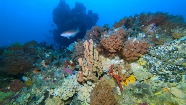
Image: A rosy wrasse swims among diverse sessile invertebrates in Franklin Marine Park (Institute for Marine and Antarctic Studies)
S4.1 Supporting information
ANZECC (Australian and New Zealand Environment and Conservation Council) (1998) Guidelines for establishing the National Representative System of Marine Protected Areas, ANZECC Task Force on Marine Protected Areas, Canberra.
ANZECC (Australian and New Zealand Environment and Conservation Council) (1999) Strategic plan of action for the National Representative System of Marine Protected Areas: a guide for action for Australian Governments, ANZECC Task Force on Marine Protected Areas, Canberra.
Barrett N, Monk J, Nichol S, Falster G, Carroll A, Siwabessy J, Deane A, Nanson R, Picard K, Dando N and Hulls J (2020) Beagle Marine Park: post survey report. Report to the National Environmental Science Program, Marine Biodiversity Hub, University of Tasmania.
Burne R, Cresswell I, Thackway R, Lyne V, Last P, Hamilton N, Blake S, Muldoon J, Phillips J Pollard D, Brown I, Billyard R, Stevens T, Edyvane K, Fotheringham D, Bosworth P, Peters D, Edgar G, Hough D and Simpson C (2006) A guide to the Integrated Marine and Coastal Regionalisation of Australia, IMCRA version 4.0.
Butler I, Patterson H, Bromhead D, Galeano D, Timmiss T, Woodhams J and Curtotti R (2024) Fishery status reports 2024, Australian Bureau of Agricultural and Resource Economics and Sciences, Canberra.
Commonwealth of Australia (2000) Environment Protection and Biodiversity Conservation Regulations 2000, Environment Australia, Canberra.
Creswell ID, Bax NJ, Constable AJ, Reid K and Smith ADM (2023) The unique marine ecosystem surrounding Macquarie Island, independent report, Australian Marine Conservation Society and Pew Charitable Trusts.
Davey C, Barrett N and Bastiaansen A (2022) Hydrographic survey of Zeehan and Franklin marine parks, west coast Tasmania, University of Tasmania.
Day J, Dudley N, Hockings M, Holmes G, Laffoley D, Stolton S and Wells S (2012) Guidelines for applying the IUCN protected area management categories to marine protected areas, IUCN, Gland, Switzerland.
Department of Environment (2014) Final approval decision for the taking of actions in accordance with an endorsed program under the Environment Protection and Biodiversity Conservation Act 1999 (Clth) (EPBC Act), Australian Government.
Department of Environment (2014) Streamlining offshore petroleum environmental approvals – program report – strategic assessment of the environmental management authorisation process for petroleum and greenhouse gas storage activities administered by the National Offshore Petroleum Safety and Environmental Management Authority under the Offshore Petroleum and Greenhouse Gas Storage Act 2006, Australian Government.
Department of Environment (2015) South-east marine region profile: a description of the ecosystems, conservation values and uses of the South-east Marine Region, Australian Government.
Devine C, Scoulding B, Althaus F and Williams A (2023) Basketwork Eel Survey 3 (October 2023) – Patience Seamount, Huon Marine Park, Voyage report NV202303, CSIRO, Australia.
Edgar GJ, Stuart-Smith RD, Willis TJ, Kininmonth S et al. (2014) Global conservation outcomes depend on marine protected areas with five key features, Nature 506:216220.
Environment Australia (2002) Australian IUCN reserve management principles for Commonwealth MPAs, National Heritage Trust, Canberra.
Hamacher D, Nunn P, Gantevoort M, Taylor R, Lehman G, Law K, Miles M (2023) The archaeology of orality: Dating Tasmania Aboriginal oral traditions to the Late Pleistocene, Journal of Archaeological Science 159:105819.
Hayes KR, Dunstan P, Woolley S, Barrett N, Howe SA, Samson CR, Bowling R, Ryan MP, Foster S, Monk J, Peel D, Hosack GR and Francis SO (2021) Designing a targeted monitoring program to support evidence based management of Australian Marine Parks: a pilot on the South-East Marine Parks Network, report to Parks Australia and the National Environmental Science Program, Marine Biodiversity Hub, Parks Australia, University of Tasmania and CSIRO, Hobart, Australia.
Hill NA, Barrett N, Lawrence E, Hulls J, Dambacher JM, Nichol S, Wiliams A and Hayes KR (2014) Quantifying fish assemblages in large, offshore marine protected areas: an Australian case study, PLoS ONE 9(10):e110831.
Hobday AJ and Pecl GT (2014) Identification of global marine hotspots: sentinels for change and vanguards for adaptation action, Reviews in Fish Biology and Fisheries 24:415425.
Ierodiaconou D, Young M and O’Brien S (2020) Hydrographic survey of Apollo Marine Park, final report to Parks Australia, Deakin University
Lawrence E, Hayes KR, Lucieer VL, Nichol SL, Dambacher JM, Hill NA, Barrett N, Kool J and Siwabessy J (2015) Mapping habitats and developing baselines in offshore marine reserves with little prior knowledge: a critical evaluation of a new approach, PLoS ONE 10(10):e0141051.
Lucieer V, Monk J, Huang Z, Nichol S, Miller K. Barrett N and Williams A (2019) An eco-narrative of Huon Marine Park: south-east marine region, report to the National Environmental Science Programme, Marine Biodiversity Hub.
Lynch TP, Foster S, Devine C, Hegarty A, McEnnulty F, Burton M and Lyle JM (2020) Trail camera video systems: investigating their utility in interpreting patterns of marine, recreational, trailer-boat fishers’ access to an offshore marine park in differing weather conditions, ICES Journal of Marine Science, 77(78):3110–3126.
Maguire K, O’Neill H, Althaus F, White W and Williams A (2023) Seamount coral reefs are egg case nurseries for deep-sea skates, Fish Biology 102(6):14551469.
Mason C, Alderman R, McGowan J, Possingham HP, Hobday AJ, Sumner M and Shaw J (2018) Telemetry reveals existing marine protected areas are worse than random for protecting the foraging habitat of threatened shy albatross (Thalassarche cauta), Diversity and Distributions 24:17441755.
May A, Mackenzie E, Davis N and Thatcher N (2022) South-East Commonwealth Marine Reserves Network Management Plan evaluation: final report, report to the Director of National Parks, Australian Government Department of Agriculture, Water and the Environment, Sustineo Pty Ltd.
McInnes J, Travers T, Pascoe P, Thalmann S, Lea M, Bird J and Raymond B (2024) The utilisation of the Macquarie Island Marine Park by seabirds and marine mammals – a review of current knowledge and future directions, draft report to Parks Australia, University of Tasmania.
Monk J, Barrett N and Bastiaansen A (2023) Zeehan and Franklin Marine Park multibeam mapping and drop-camera validation for Parks Australia, report to Parks Australia, Institute for Marine and Antarctic Studies, University of Tasmania.
Monk J, Barrett NS, Hill NA, Lucieer VL, Nichol SL, Siwabessy JPW and Williams SB (2016) Outcropping reef ledges drive patterns of epibenthic assemblage diversity on cross-shelf habitats, Biodiversity and Conservation 25:485502.
Monk J, Barrett NS, Hulls J, James L, Hosack G, Oh E, Martin T, Edwards S, Nau A, Heaney B and Foster S (2016) Seafloor biota, rock lobster and demersal fish assemblages of the Tasman Fracture Commonwealth Marine Reserve Region: determining the influence of the shelf sanctuary zone on population demographics, report to the National Environmental Research Program, Marine Biodiversity Hub, University of Tasmania.
Monk J, Williams J, Barrett N, Jordan A, Lucieer V, Althaus F and Nichol S (2017) Biological and habitat feature descriptions for the continental shelves of Australia’s temperate-water marine parks including collation of existing mapping in all AMPs, report to the National Environmental Science Programme, Marine Biodiversity Hub, Institute of Marine and Antarctic Studies, University of Tasmania.
Navarro M, Langlois TJ, Burton M, Hegarty A, Aston C, Kragt ME and Rogers A (2021) Social and economic benchmarks of the Australian Marine Parks, report to the National Environmental Science Program, Marine Biodiversity Hub, University of Western Australia.
O’Hara T (2019) The eastern Australian Marine Parks: biodiversity, assemblage structure, diversity and origin, report to Parks Australia, National Environmental Science Program Marine Biodiversity Hub, Museums Victoria.
O’Hara TD, Smith PJ, Mills VS, Smirnov I and Steinke D (2013) Biogeographical and phylogeographical relationships of the bathyal ophiuroid fauna of the Macquarie Ridge, Southern Ocean, Polar Biology 36:321–333.
O’Hara TD, Williams A, Althaus F, Ross AS and Bax NJ (2020) Regional-scale patterns of deep seafloor biodiversity for conservation assessment, Biodiversity Research 26(4):479494.
Perkins N, Monk J and Barrett N (2021) Analysis of a time-series of benthic imagery from the South-east Marine Parks Network, report to Parks Australia, University of Tasmania.
Perkins N, Monk J, Bastiaansen A, Hulls J and Barrett N (2024) Fish assemblages on the continental shelves of Freycinet and Huon Marine Parks: insights from stereo BUV and ROV surveys, report to Parks Australia, University of Tasmania.
Perkins N, Monk J, Wong R, Bento de Almeida J and Barrett N (2024) Autonomous Underwater Vehicle-based benthic fauna surveys and monitoring of Huon Marine Park and Freycinet Marine Park shelf habitats 2022/2023, report to Parks Australia, University of Tasmania.
Perkins N, Monk J, Wong R, Willis S, Bastiaansen A and Barrett N (2022) Changes in rock lobster, demersal fish, and sessile benthic organisms in the Tasman Fracture Marine Park: comparisons between 2015 and 2021, report to the Parks Australia, Institute for Marine and Antarctic Studies, University of Tasmania.
Rowden AA and Voyage Participants (2008) Voyage report, McRidge 2 – TAN0803, National Institute of Water and Atmospheric Research, New Zealand.
Terauds A, Gales R, Barry Baker G and Alderman R (2006) Foraging areas of black-browed and grey-headed albatrosses breeding on Macquarie Island in relation to marine protected areas, Aquatic Conservation: Marine and Freshwater Ecosystems 16(2):133–146.
Thresher RE, Guinotte JM, Matear RJ and Hobday AJ (2015) Options for managing impacts of climate change on a deep-sea community, Nature Climate Change 5:635639.
Thresher RE, Althaus F, Adkins J, Gowlett-Holmes K, Alderslade P, Dowdney J, Cho W, Gagnon A, Staples D, McEnnulty F and Williams A (2014) Strong depth-related zonation of megabenthos on a rocky continental margin (~700-4000m) off southern Tasmania, Australia, PLoS ONE 9(1):e85872.
Thresher RE, Tilbrook B, Fallon S, Wilson NC and Adkins J (2011) Effects of chronic low carbonate saturation levels on the distribution, growth and skeletal chemistry of deep-sea corals and other seamount megabenthos, Marine Ecology Progress Series 442:8799.
Trebilco R, Fischer M, Hunter C, Hobday A, Thomas L and Evans K (2021) Australia state of the environment 2021: marine, independent report to the Australian Government Minister for the Environment, Commonwealth of Australia, Canberra.
Vandenbossche P and Davey C (2018) Hydrographic survey of the Boags Commonwealth Marine Reserve in southwestern Bass Strait, report to the Institute for Marine and Antarctic Studies, University of Tasmania and Parks Australia.
Wienecke B and Robertson G (2002) Foraging areas of king penguins from Macquarie Island in relation to a marine protected area, Environmental Management 29(5):662672.
Williams A, Althaus F, Barker B, Kloser R and Keith G (2007) Using data from the proposed Zeehan MPA to provide an inventory of benthic habitats and biodiversity, and evaluate prospective indicators for monitoring and performance assessment: research and monitoring for benthic ecosystems in marine protected areas of the South-east Marine Region, final report to the Department of the Environment and Water Resources.
Williams A, Althaus F, Green M, Maguire K, Untiedt C, Mortimer N, Jackett CJ, Clark M, Bax N, Pitcher R and Schlacher T (2020) True size matters for conservation: a robust method to determine the size of deep-sea coral reefs shows they are typically small on seamounts in the southwest Pacific Ocean, Frontiers in Marine Science 7:187.
Williams A, Althaus F, Maguire K, Green M, Untiedt C, Alderslade P, Clark MR, Bax N and Schlacher TA (2020) The fate of deep-sea coral reefs on seamounts in a fishery-seascape: what are the impacts, what remains, and what is protected?, Frontiers in Marine Science 7:567002.
Williams A, Green M, Untiedt C, Maguire K, Althaus F, Alderslade P and Bax N (2020) Status of deep-sea seamount coral and fish communities, and recovery from trawling, in the Tasman Fracture Marine Park and Huon Marine Park, final report to Parks Australia.
Williams A, Osterhage D, Althaus F, Ryan T, Green M and Pogonoski J (2021) A very large spawning aggregation of a deep-sea eel: magnitude and status, Journal of Marine Science and Engineering 9(7):723.
Young M, Doran T, Simmons H, Cardilini A, Ierodiaconou D and Whitmarsh S (2024) Apollo Marine Park: habitat mapping and biodiversity assessment, draft report to Parks Australia, Deakin University.
S4.2 Map data sources
Spatial data sources for individual park maps:
DCCEEW (2024): Australian Marine Parks
DCCEEW (2023): Collaborative Australian Protected Areas Database 2022
Geoscience Australia (2020): Australian Maritime Boundaries
Geoscience Australia (2006): GEODATA TOPO 2050K
Geoscience Australia (2005): Australian Bathymetry and Topography
Aeronautical Information Services – Airforce (2016): Danger and restricted airspace
regions over Australia
Australian Fisheries Management Authority (2014): Commonwealth Fishing Activity
(Status Report)
Australian Maritime Safety Authority (2015): Automatic Identification System (Shipping)
Department of the Environment and Energy (2018): Australia’s Network of Marine Parks
Department of the Environment and Energy (2015): Key Ecological Features
Department of the Environment and Energy (2016): Collaborative Australian Protected
Areas Database
Department of the Environment and Energy (2012): Commonwealth Marine Regions
Department of the Environment and Energy (2011): Bathomes within Australian waters
Department of the Environment and Energy (2006): Integrated Marine and Coastal Regionalisation of Australia v.4.0 Provincial Bioregions
Department of Prime Minister and Cabinet (Environment branch – Indigenous Employment
and Recognition Division) (2017): Indigenous Protected Areas – dedicated
ESRI Australia Pty Ltd (1992): ARCWORLD World Dataset 1:3 million
Geoscience Australia (2014): Australian Maritime Boundaries (AMB) v3
Geoscience Australia (2006): GEODATA TOPO 250K
Geoscience Australia (2006): GEODATA TOPO 2.5 M
Geoscience Australia (2005): Australian Bathymetry and Topography
Geoscience Australia (2004): Geomorphic Features of the EEZ
Geoscience Australia (2004): GEODATA TOPO 100k – Coastline
National Geospatial – Intelligence Agency (2012): World Port Index
PBEncom Petroleum Information (2017): GPInfo petroleum exploration database.
action | Has the meaning given by section 523 of the EPBC Act. |
artificial reef | Has the meaning given by the Environment Protection (Sea Dumping) Act 1981 namely, a structure or formation placed on the seabed: (a) for the purpose of increasing or concentrating populations of marine plants and animals, or (b) for the purpose of being used in human recreational activities. |
Australian Government or the Government | The Government of the Commonwealth of Australia. |
Australian IUCN reserve management principles | The EPBC Act (section 348) requires the EPBC Regulations to prescribe principles for each IUCN category. These principles are the Australian IUCN reserve management principles and are found in Schedule 8 of the EPBC Act. |
Australian Marine Parks or marine park | Protected areas in Commonwealth waters, managed to protect natural and cultural values and support ecologically sustainable use.
They are Commonwealth reserves, named as Marine Parks, declared by the Governor-General by Proclamation under section 344 of the EPBC Act. |
authorisation | As described in Section 4.5 (Authorisation of activities) of this plan. |
ballast water | Water taken on board by vessels to maintain stability and trim. |
bathomes | Large spatial areas characterised by bathymetric (depth-related) distribution of biota. |
benthic | Anything associated with or occurring on the bottom of a body of water. |
biodiversity or biological diversity | Has the meaning given by section 528 of the EPBC Act. |
biologically important areas | Areas where a protected species displays a biologically important behaviour such as breeding, foraging, resting or migration. These areas serve to highlight the parts of a marine region that are particularly important for the conservation of protected species. |
bioregion (provincial and mesoscale) | A large area that has similar types of plants, animals and ocean conditions compared with other similarly sized areas and, in this document, those bioregions as defined in the Integrated Marine and Coastal Regionalisation of Australia Version 4.0. Australia’s marine environment is divided into 41 provincial bioregions in waters deeper than 200 m, and 60 mesoscale bioregions in waters shallower than 200 m. |
bioregional plan | Has the meaning given by section 528 of the EPBC Act. |
CAR | Comprehensiveness – includes the full range of ecosystems recognised at an appropriate scale within and across each bioregion. Adequacy – the maintenance of the ecological viability and integrity of populations, species and communities. Representativeness – those marine areas that are selected for inclusion in reserves should reasonably reflect the biotic diversity of the marine ecosystems from which they derive. |
class approval | As described in Section 4.5.3 (Class approvals) of this plan. |
climate change | A change in the Earth’s long-term climate conditions and patterns caused by human activities, such as burning fossil fuels and deforestation, altering the composition of the global atmosphere. |
commercial aquaculture | Farming and culturing of aquatic organisms, such as fish, crustaceans and molluscs. |
commercial fishing | Has the meaning given by section 390SC(1A) of the EPBC Act: a fishing activity that is engaged in for a commercial purpose and, to avoid doubt, does not include an activity that constitutes recreational fishing. |
Commonwealth marine area | Has the meaning given by section 24 of the EPBC Act. |
Commonwealth marine environment | The environment in the Commonwealth marine area. |
Commonwealth reserve | A reserve established and managed under Division 4 of Part 15 of the EPBC Act, including Australian Marine Parks. |
Commonwealth waters | Commonwealth waters that start at the outer edge of state and territory waters, generally 3 nm (approximately 5.5 km) from the shore and extend to the outer boundary of Australia’s Exclusive Economic Zone, 200 nm (approximately 370 km) from the shore. |
Cultural values | Cultural values are broadly understood to be the tangible and intangible aspects of culture that people may want to protect, maintain, and pass on to future generations – including places, objects, collections and archives, knowledge and cultural practices. |
department | The Australian Government department responsible for administering the EPBC Act. At the time of preparing this plan, this is the Department of Climate Change, Energy, the Environment and Water or such other department or agency that succeeds to the functions of the department. |
Director of National Parks (Director) | The Director of National Parks (Director) as established under section 514A of the EPBC Act and described in Section 1.4 of this plan, including any person to whom the Director has delegated powers and functions under the EPBC Act in relation to the
South-east Marine Parks Network. |
dropline | A line that is vertically set or suspended in the water column between a weight (normally in contact with the seabed) and a vessel or a buoy on the water surface. Baited hooks are attached to the mainline via smaller lines (branch-lines or snoods). |
ecologically sustainable use | Has the meaning given by section 528 of the EPBC Act. |
ecosystem | Has the meaning given by section 528 of the EPBC Act. |
endemic/endemism | Native to or confined to a certain region. |
environment | Has the meaning given by section 528 of the EPBC Act. |
EPBC Act | Environment Protection and Biodiversity Conservation Act 1999 (Cth). |
EPBC Regulations | Environment Protection and Biodiversity Conservation Regulations 2000 (Cth). |
Exclusive Economic Zone (EEZ) | Marine area beyond the territorial sea over which Australia has sovereign rights for the purpose of exploring and exploiting, conserving and managing all natural resources. |
fish aggregating device | Has the meaning given by the Sea Installation Act 1987: (a) a man‑made structure that, when in, or brought into, physical contact with the seabed or when floating, is used solely for the purpose of attracting populations of fish so as to facilitate the taking of those fish, or (b) any electronic or other equipment designed or intended to be ancillary to, or associated with, such a structure while it is being used, or in order to facilitate the use of the structure, for that purpose, but does not include a net, trap or other equipment for taking, catching or capturing fish. |
hand collection | Removing species from rocks, crevices, the seafloor or other benthic substrate by hand using dive hookah, self-contained underwater breathing apparatus (scuba) or snorkel. |
hand net (hand, barrier, skimmer, cast, scoop, drag, lift) | A small mesh net that is operated by hand to trap fish, including a hand net, barrier net, skimmer net, cast net, scoop net, drag net and lift net. |
Indigenous Protected Area (IPA) | An area voluntarily dedicated for protection by Indigenous groups on Indigenous owned or managed land or Sea Country. IPAs are recognised by the Australian Government as part of the National Reserve System, protecting the nation’s biodiversity for the benefit of all Australians. Most IPAs are dedicated to promoting a balance between conservation and other sustainable uses to deliver social, cultural and economic benefits for local Indigenous communities. IPAs combine traditional and contemporary knowledge into a framework to leverage partnerships with conservation and commercial organisations and provide employment, education and training opportunities for Indigenous people. |
Integrated Marine and Coastal Regionalisation of Australia (IMCRA) | A spatial framework for classifying Australia’s marine environment into bioregions that forms the basis for the development of a National Representative System of Marine Protected Areas. |
International Convention for the Prevention of Pollution from Ships (MARPOL) | The International Maritime Organisation (IMO) convention covering prevention of pollution of the marine environment by ships from operational or accidental causes. This is the main international convention for the prevention of ship-sourced pollution in the marine environment. MARPOL addresses pollution that might result from accidents such as collisions or groundings, as well as all types of waste generated during the normal operation of a ship. Ships are permitted to discharge small quantities of certain wastes, subject to very strict controls. |
International Maritime Organization (IMO) | The United Nations specialised agency with responsibility for the safety and security of shipping and the prevention of marine and atmospheric pollution by ships. |
International Union for the Conservation of Nature (IUCN) | A democratic union that brings together member states (countries), non-government organisations, United Nations agencies, companies and local communities to discuss and promote solutions to international environment and development challenges. |
key ecological feature | Elements of the Commonwealth marine environment that, based on best available scientific understanding, are considered to be of regional importance for either the region's biodiversity or ecosystem function and integrity. |
longline (demersal, auto-longline) | A line that is horizontally set along the seafloor between weights to maintain contact with the seafloor. The main line has a vertical line attached at each end which is connected to buoys on the water surface. Baited hooks are attached to the main line via smaller lines (branch-lines or snoods). An auto-longline is a longline where the hooks are baited by a machine rather than manually. |
longline (pelagic) | A line that is horizontally set near the surface of the water and avoids contact with the seafloor. The main line has a vertical line attached at each end which is connected to buoys on the surface of the water. Baited hooks are attached to the main line via smaller lines (branch-lines or snoods). Buoys are generally used intermittently along the main line to help maintain buoyancy in the water column. The line may be left to drift in the water or be anchored by vertical lines to the seafloor. |
management actions | Actions that park managers and partners can take to reduce the pressures affecting key values, directly improve the condition of values or enhance benefits to park users. |
management category | An IUCN category prescribed by Schedule 8 of the EPBC Regulations. |
management principles | Australian IUCN reserve management principles prescribed by regulation 10.04 and Schedule 8 of the EPBC Regulations. |
mesophotic | Meaning ‘middle-light’ or marine ecosystems at depths ranging from 30 m to 70 m. |
mining operations | Has the meaning given by section 355(2) of the EPBC Act. |
Minister | The Minister responsible for administering the EPBC Act. |
minor line (handline, rod and reel, trolling, squid jig, poling) | Any line fishing with a small number of hooks, often just one (i.e. handline, rod and reel, squid jigging and pole fishing). Trolling is dragging a lure or baited hook behind a moving vessel and reeling it in (by hand, reel or winches). Poling is dragging a lure or baited hook on a fixed length of line behind a vessel and flicking or gaffing the fish into the boat. Squid jigging involves vertical lines with several barbless lures being mechanically jigged up and down to attract squid. |
native title | Has the meaning given by section 223 of the Native Title Act 1993 (Cth). |
net (demersal) | A rectangular mesh net anchored to the seafloor with weights. The net may have small floats along the upper line to maintain its shape in the water. Each end has a vertical line that is connected to buoys on the surface of the water. |
net (pelagic) | A rectangular mesh net set near the surface of the water that is not in contact with the seafloor. The net generally has floats along the upper line to maintain buoyancy. Each end is connected to a buoy on the surface of the water. The net can be left to drift or connected to a boat. |
news of the day | Contemporary reporting in relation to an unanticipated event that has occurred in or adjacent to a marine park. It does not include general items about a marine park or planned activities in the park. |
NOPSEMA | National Offshore Petroleum Safety and Environmental Management Authority. |
OPGGS Act | Offshore Petroleum and Greenhouse Gas Storage Act 2006 (Cth). |
plan, the plan, this plan or management plan | Means this management plan for the South-east Marine Parks Network unless otherwise stated. |
Parks Australia | The Australian Government organisation that supports the Director of National Parks. |
pelagic | The water column, not near the seafloor or the shore. |
pelagic fishing gear | Fishing gear that does not come in contact with the seabed during use. |
permit | As described in Section 4.5.2 (Permits) of this plan. |
prescription | Mandatory requirements for activities in the South-east Marine Parks Network as outlined in Chapter 4 of this plan. |
pressures | |
protected species | Species listed under the EPBC Act as threatened, migratory or marine species and/or cetaceans (whales, dolphins and porpoises). |
purse seine | A semi-rectangular mesh net with floats along the top and a weighted line along the bottom. A vessel or buoy is used to anchor one end of the net while it is set around a fish aggregation in a circular pattern. The bottom of the net has a cable threaded through it which, when pulled, brings the bottom of the net together like a purse trapping the fish inside. The net is then pulled toward the vessel and the fish are either lifted or pumped on board the vessel. |
Ramsar | The Convention on Wetlands of International Importance (the Ramsar Convention), signed in Ramsar, Iran, in 1971. The Ramsar Convention aims to halt the worldwide loss of wetlands and to conserve, through wise use and management, those that remain. |
rariphotic | Meaning ‘low-light’ or marine ecosystems at depths ranging from 71 m to 200 m. |
recreational fishing | Taking marine species, including shells, not for commercial purposes and that is not commercial fishing. |
Sea Country | The areas of the sea that Aboriginal and Torres Strait Islander groups are particularly affiliated with through their traditional lore and customs. |
seamounts | Underwater mountains that rise from the ocean floor without reaching the surface. Most are remnants of extinct volcanoes, while others are actively erupting and growing. |
social and economic benefits | Benefits to people, businesses and the economy arising from the protection and sustainable use of values. |
South-east Marine Parks Network, or South-east Network, or the network | The 14 marine parks described in Schedule 1 (South-east Marine Parks overview) and managed as a network. |
stowed and secured | All fishing apparatus, including nets and lines, are rendered inoperative in zones where fishing is not permitted, including that the apparatus is inboard the vessel and otherwise completely out of the water or as determined by the Director. |
Traditional Owners | A local descent group of Indigenous persons who have common spiritual affiliations to an area of Sea Country and are entitled by Indigenous traditions to fish and hunt in an area of Sea Country. |
transit | Continuous and expeditious passage through an area. However, passage includes stopping and anchoring, but only in so far as rendered necessary by force majeure or distress or for the purpose of rendering assistance to persons, ships or aircraft in danger or distress. |
trap, pot | Made in a variety of shapes and sizes from various materials. They are generally baited to attract fish or crustaceans through one or more entrances or openings. Traps and pots are set on the seafloor and connected to a vertical line with a buoy on the surface of the water. |
trawl (demersal) | A cone-shaped mesh net towed through the water column on or near the seabed that may come into contact with the seabed during use. The net is held open horizontally by otter boards or trawl doors while towing. The bottom of the net opening generally has chains, rubber or steel bobbins and spacers threaded along its length to help reduce snagging by slightly lifting the net off the seafloor. The last section of the net is a cod end, where the catch is retained. Long metal cables connect the net and boards to a vessel. The cable length and mesh size vary depending on the species being targeted (fish or prawns). These nets can be towed by one vessel in various configurations such as 1 or 4 nets. |
trawl (midwater) | A cone-shaped mesh net towed through the water column that does not come into contact with the seabed at any stage during use. The net is held open horizontally by otter boards or trawl doors while towing. The bottom of the net opening is weighted. The last section of the net is a cod end, where the catch is retained. Long metal cables connect the net and boards to a vessel. The cable length and mesh size vary depending on the species being targeted (fish or prawns). These nets can be towed by one vessel in various configurations, such as 1 or 4 nets. |
trotline | Very similar to a demersal longline. It is a line that is horizontally set along the seafloor. The main line has a vertical line attached at each end which is connected to buoys on the surface of the water. Baited hooks are attached to the main line via smaller lines (branch-lines or snoods). Buoys are used intermittently along the main line to lift baited hooks away from the seafloor. |
UNCLOS | United Nations Convention on the Law of the Sea, concluded at Montego Bay on 10 December 1982. |
values | The natural and cultural features in the parks that require protection and conservation. Defined in Section 2.3 of this plan. |
vessel identification and monitoring system (VMS) | A system whereby vessels are fitted with an electronic device that can transmit or provide information to a central management agency about the vessel’s course or position or other such information. |
zones | Set out what you can and cannot do in Australian Marine Parks, as outlined in Section 4.1 of this plan. |