Environment Protection and Biodiversity Conservation (Cocos (Keeling) Islands Marine Park Management Plan) Instrument 2025
I, Tanya Plibersek, Minister for the Environment and Water, approve, under subparagraph 370(3)(b)(i) of the Environment Protection and Biodiversity Conservation Act 1999, this instrument, that is a legislative instrument made by me on the day of this approval under subsection 371(1) of that Act.
Dated 17 January 2025
Tanya Plibersek
Minister for the Environment

How to cite this document
Director of National Parks, Cocos (Keeling) Islands Marine Park Management Plan 2025
Director of National Parks Australian business number: 13 051 694 963
This plan is available online via parksaustralia.gov.au/marine.
This document is licensed under a Creative Commons Attribution-Non Commercial-No Derivatives 4.0 International licence, with the exception of the Coat of Arms of the Commonwealth of Australia, government agency logos, content supplied by third parties and all images.
For licence conditions see: https://creativecommons.org/licenses/by-nc-nd/4.0
ISBN: 978-0-646-89797-4
Cover photo: Hermit crab (Vikki Lauritsen)
Contents
Vision__________________________________________________________________________6
Objectives______________________________________________________________________7
Foreword_______________________________________________________________________7
Acknowledgements_______________________________________________________________8
1.0 Introduction_______________________________________________________________9
1.1 Introductory provisions_______________________________________________________10
1.2 Management plan overview___________________________________________________10
1.3 Australian marine parks______________________________________________________11
1.4 Context for management_____________________________________________________11
2.0 Cocos (Keeling) Islands Marine Park___________________________________________12
2.1 About Cocos (Keeling) Islands Marine Park________________________________________12
2.2 People and community_______________________________________________________17
2.3 Values of Cocos (Keeling) Islands Marine Park_____________________________________18
2.3.1 Natural values.........................................................19
2.3.2 Cultural values.........................................................25
2.3.3 Social and economic values...............................................29
2.4 Pressures and drivers in Cocos (Keeling) Islands Marine Park__________________________30
2.4.1 Climate and environmental change..........................................31
2.4.2 Marine debris and other pollution...........................................32
2.4.3 Water quality..........................................................33
2.4.4 Marine invasive species and disease.........................................33
2.4.5 Coastal development and infrastructure.......................................33
2.4.6 Fishing pressure.......................................................34
2.4.7 Recreational and tourism activities..........................................34
2.5 Pulu Keeling National Park____________________________________________________34
2.6 Management of values, pressures and drivers______________________________________35
3.0 Management programs and actions____________________________________________37
3.1 Management programs, goals, desired outcomes and actions.......................37
3.2 Monitoring, evaluation and reporting.........................................40
3.3 Community advisory committee............................................40
4.0 Management of activities____________________________________________________42
4.1 Zone categories, names and objectives___________________________________________43
4.2 Outline of activity management_________________________________________________43
4.3 Prescriptions for activities_____________________________________________________44
4.3.1 General use and access..................................................46
4.3.2 Commercial shipping....................................................47
4.3.3 Commercial fishing.....................................................48
4.3.4 Commercial aquaculture..................................................49
4.3.5 Commercial media......................................................49
4.3.6 Commercial tourism.....................................................50
4.3.7 Recreational fishing.....................................................50
4.3.8 Mining...............................................................51
4.3.9 Structures and works....................................................51
4.3.10 Research, monitoring and restoration........................................52
4.3.11 National security and emergency response....................................53
4.3.12 Waste management.....................................................53
4.3.13 Non-commercial remotely piloted aircraft (drones)...............................54
4.3.14 Red-footed booby (sula sula) harvest (Pengambilan burung maen‑maen).......55
4.3.15 Activities governed by the EPBC Regulations..................................55
4.3.16 New activities and authorisations...........................................56
4.4 Making decisions about activities_______________________________________________57
4.4.1 Decision making.......................................................57
4.4.2 Assessment under other processes..........................................57
4.4.3 Review of decisions.....................................................57
4.5 Authorisation of allowable activities______________________________________________58
4.5.1 Permits..............................................................58
4.5.2 Class approvals........................................................59
4.5.3 Activity licences and leases...............................................60
Schedule 1 International agreements______________________________________________62
Schedule 2 References and maps________________________________________________64
Select references_______________________________________________________________64
Maps________________________________________________________________________66
Glossary______________________________________________________________________71
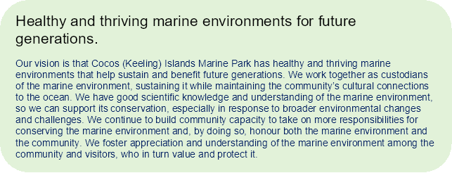

The vision statement was developed with input from a range of Cocos (Keeling) Island community members and is designed to reflect the island community’s aspirations for the local marine environment and Cocos (Keeling) Islands Marine Park.
Note on translations: Cocos Malay is the most commonly spoken language on Cocos (Keeling) Islands and an important part of Cocos Malay culture. The management plan recognises this by providing Cocos Malay translations for key passages of text, and for species and places where appropriate.
The objectives of Cocos (Keeling) Islands Marine Park are:
- To protect and conserve biodiversity and other natural and cultural values
- To provide for ecologically sustainable use that supports positive social and economic outcomes.
Tujuan Taman Lautan Pulu Cocos (Keeling) adalah untuk menyediakan:
- Untuk melindungi dan memelihara biodiversiti dan nilai alam semula-jadi dan kebudayaan yang lain.
- Untuk menyediakan penggunaan yang bertahanan dari segi ekologi yang menyokong hasil sosial dan ekonomi yang positif.
Emerging from the depths of the Indian Ocean, Cocos (Keeling) Islands and its surrounding waters are home to extensive coral reef and lagoon habitats that provide a haven for a diverse array of marine species, including migratory, threatened and endemic species. Cocos (Keeling) Islands Marine Park was proclaimed in March 2022 to protect this marine environment and support its sustainable use. The park extends across 467,054 km2 of ocean, safeguarding much of the islands’ inshore waters as well as deep, offshore seamounts, plains and ridgelines.
Cocos (Keeling) Islands Marine Park adjoins Pulu Keeling National Park, connecting and increasing protections across land and sea for seabirds, marine turtles and other species that require both environments for their survival.
The waters of Cocos (Keeling) Islands are not only a sanctuary for marine life; they are also critical for the local Cocos Malay community, which has an ongoing multigenerational connection to the marine environment that is of enormous cultural and socio-economic significance. For nearly 2 centuries, Cocos Malay people have relied on the waters of Cocos for their livelihoods, sustenance and general wellbeing. In recognition of the local community’s connection to the marine environment, the original design of Cocos (Keeling) Islands Marine Park and the preparation of this management plan have been undertaken collaboratively with local people.
The Director of National Parks is grateful to the Cocos (Keeling) Islands community as well as scientific experts and other stakeholders for their contribution to the creation of this significant marine park and its management. Together, we are entrusted with helping ensure Cocos (Keeling) Islands Marine Park is healthy and thriving for the benefit of future generations.
Timbul dari kedalaman Lautan Hindi, Pulu Cocos (Keeling) dan lautan sekitarnya adalah rumah kepada berbagai jenis karang dan tempat tinggal lagun yang luas, menyediakan tempat berlindung bagi berbagai jenis binatang laut, termasuk jenis yang menumpang, terancam dan endemik. Taman Lautan Pulu Cocos (Keeling) telah digelarkan pada March 2022 untuk menjaga persekitaran lautan ini dan menyokong penggunaannya yang bertahanan. Taman ini seluas lautan 467,054 kilometer persegi, melindungi sebahagian lautan dibahgian dalam pulu serta ayer dalam, seamount dilautan luaran, lapangan lautan dan pinggiran bukit dibawa laut.
Taman lautan bersebelahan Taman Negara Pulu Keeling, menyambung dan menambah penjagaan dipersekitaran tanah dan lautan untuk burung-burung, penyu dan jenis lain yang memerlukan kedua-dua alami untuk kehidupan mereka.
Lautan Pulu Cocos (Keeling) bukan hanya tempat perlindungan untuk binatang lautan, tetapi mereka juga penting untuk masyarakat Melayu Cocos, yang mempunyai perhubungan berberapa generasi kepada alami lautan yang menjadi kebudayaan dan kepentingan socio-ekonomik. Untuk hampir dua abad, orang Melayu Cocos bergantung dengan lautan Cocos untuk kehidupan, rezeki dan kesihatan mereka. Sebagai pengakuan atas hubungan masyarakat tempatan dengan persekitaran lautan, desain asli taman lautan dan persiapan rencana pengurusan ini dilakukan sebagai usaha kerjasama dengan masyarakat tempatan.
Director of National Parks merasa bangga terhadadp masyarakat Pulu Cocos (Keeling) serta juga ahli scientific dan pihak-pihak penting yang lain atas bantuan mereka terhadap pembinaan taman lautan yang penting ini serta penggurusannya. Bersama, kita diamanahkan dalam membantu memastikan Taman Lautan Pulu Cocos (Keeling) sihat dan berkembang untuk manfaat generasi yang akan datang.
The Director of National Parks thanks the many individuals and organisations from Cocos (Keeling) Islands and other stakeholders that contributed to the establishment of Cocos (Keeling) Islands Marine Park and to this management plan. The community’s willingness to engage proactively and positively in a genuine co-design process will help ensure that this marine park delivers the best possible outcomes. The Director acknowledges the work of the Cocos (Keeling) Islands Marine Park Management Plan Committee, members of which volunteered their time, knowledge and expertise over an 18‑month period to help prepare this management plan.
Director of National Parks berterima kasih kepada banyak orang-orang dan pihak-pihak dari Pulu Cocos (Keeling) dan pihak-pihak penting yang lain yang telah membantu dalam pertubuhan Taman Lautan Pulu Cocos (Keeling) dan juga hingga rencana pengurusan ini. Kesediaan masyarakat untuk melibatkan diri secara proaktif dan positif dalam proses desain bersama yang tulus akan membantu memastikan taman lautan ini memberikan hasil yang terbaik. Director mengakui kerja Komiti Rencana Pengurusan Taman Lautan Pulu Cocos (Keeling), yang menyumbangkan masa, pengetahuan dan kepakaran mereka secara voluntir dalam tempoh 18 bulan untuk membantu menyediakan rencana pengurusan ini.

Image: Burung maen-maen (red-footed booby) (sula sula) (Parks Australia)
Name
This instrument is the Environment Protection and Biodiversity Conservation (Cocos (Keeling) Islands Marine Park Management Plan) Instrument 2025.
Commencement
This instrument commences on the day after it is registered on the Federal Register of Legislation
Authority
This instrument is prepared by the Director of National Parks under sections 366 and 368 of the Environment Protection and Biodiversity Conservation Act 1999 (EPBC Act) and is approved by the Minister under sections 370(3) and 371(1) of the EPBC Act.

Figure 1.1 Overview of the management plan
Cocos (Keeling) Islands Marine Park is one of a national network of Australian marine parks managed by Parks Australia under the direction of the Commonwealth Director of National Parks. These marine parks have been established in Commonwealth waters across all Australian marine regions as part of Australia’s National Representative System of Marine Protected Areas (NRSMPA). Marine parks have also been established by state and territory governments in their respective waters as part of this system.
Pulu Keeling National Park is also managed by Parks Australia. It has protected North Keeling Island and a small marine area around the island since 1995. However, until March 2022, when Cocos (Keeling) Islands Marine Park and Christmas Island Marine Park were established, the waters of Australia’s Indian Ocean Territories were a key gap in the NRSMPA. Like Pulu Keeling National Park and other Australian marine parks, Cocos (Keeling) Islands Marine Park is a Commonwealth Reserve, proclaimed under the EPBC Act.
Cocos (Keeling) Islands is one of Australia’s Indian Ocean Territories (IOT) and is governed by the Australian Government. An Administrator appointed by the Governor-General of Australia represents the Australian Government in these territories.
At the time this plan is made, the Commonwealth Department of Infrastructure, Transport, Regional Development, Communications and the Arts (DITRDCA) is responsible for overseeing administration of the IOT, including the management of fisheries on Cocos (Keeling) Islands. Most state-level services such as education, water, electricity generation and distribution and community services are provided by Western Australian Government agencies through service delivery arrangements with the Commonwealth. Local government functions and services are provided by the Shire of Cocos (Keeling) Islands.
The Director of National Parks is required to prepare management plans for Australian marine parks. In recognition of the importance of the marine environment, Commonwealth marine areas, including marine park areas, are listed as matters of national environmental significance under the EPBC Act.
This plan complements a range of Commonwealth, state and territory laws, as well as international conventions and agreements that relate to protection of the marine environment (Schedule 1). Some of the ways in which the Australian Government protects the marine environment through national environmental law are management plans for Australian marine parks; recovery plans for threatened species; and threat abatement plans for key threats, such as invasive species and marine debris.
Effective management of Cocos (Keeling) Islands Marine Park will be achieved by working in partnership with local communities, marine park users and other government agencies. In particular:
- a locally based Community Advisory Committee will be established to advise on the implementation of this plan (Section 3.3 (Community advisory committee))
- the Director will build on existing relationships with the Shire of the Cocos (Keeling) Islands, research institutions and government agencies with relevant responsibilities in IOT waters, including DITRDCA, the Western Australian Department of Water and Environment Regulation, the Australian Maritime Safety Authority, the Department of Defence, Australian Border Force and the Department of Agriculture, Fisheries and Forestry.

Image: ‘Above and Below’ Cocos (Keeling) Islands (Mitch McNear)
Cocos (Keeling) Islands Marine Park covers 467,054 km2 of the Indian Ocean surrounding Cocos (Keeling) Islands nearly the entirety of Australia’s waters around this remote external territory. It protects a diversity of pelagic and seafloor features, with water depths from 0 m to over 6,000 m. The marine park is assigned 2 International Union for the Conservation of Nature (IUCN) categories across 4 zones: a large ‘green’ National Park Zone (IUCN II) covering the entirety of the islands’ offshore waters, 2 small green zones protecting important inshore habitats, and a ‘yellow’ Habitat Protection Zone (Cocos (Keeling) Islands) (IUCN IV) covering most of the islands’ inshore waters. Green zoning provides a high level of protection – for example, mining and fishing are not allowed. Yellow zoning also provides significant protection, while allowing locally important activities like recreational fishing to continue. The active port area over the northern half of the southern atoll lagoon and the seawalled shorelines of Home Island and West Island were not incorporated into the marine park, ensuring certainty for activities and infrastructure critical for community services and the operation of the islands, such as the ferry service, freight services, fuel loading and seawall maintenance.
The Cocos (Keeling) Islands marine region supports high levels of species richness and diversity, including varieties of marine fauna found nowhere else in the world. The southern atoll lagoon system and outer coral reefs provide habitat for species from both Indian and Pacific Ocean bioregions, and over 600 species of fish have been recorded. The overlap of these bioregions in this area has given rise to the evolution of hybrid marine fauna, as well as some endemic species.
The offshore deep-sea marine environment of the marine park is characterised by ridges, plains and seamounts, including Muirfield Seamount, around 130 km to the south‑west of Cocos (Keeling) Islands, which rises to within 20 m of the surface and is abundant with marine life.
The Cocos (Keeling) Islands marine environment supports species such as penyu (marine turtles), cucut (sharks) and ikan hijau (humphead Māori wrasse). The lagoon ecosystem provides shallow, sheltered waters for juvenile fish species, as well as deeper coral habitats that support them as they mature. The marine park adjoins Pulu Keeling National Park, connecting and increasing protection across land and sea for species like burung bebek (masked booby seabirds) and green turtles, which require both environments for their survival.

Figure 2.1 Cocos (Keeling) Islands Marine Park offshore National Park Zone (IUCN II)
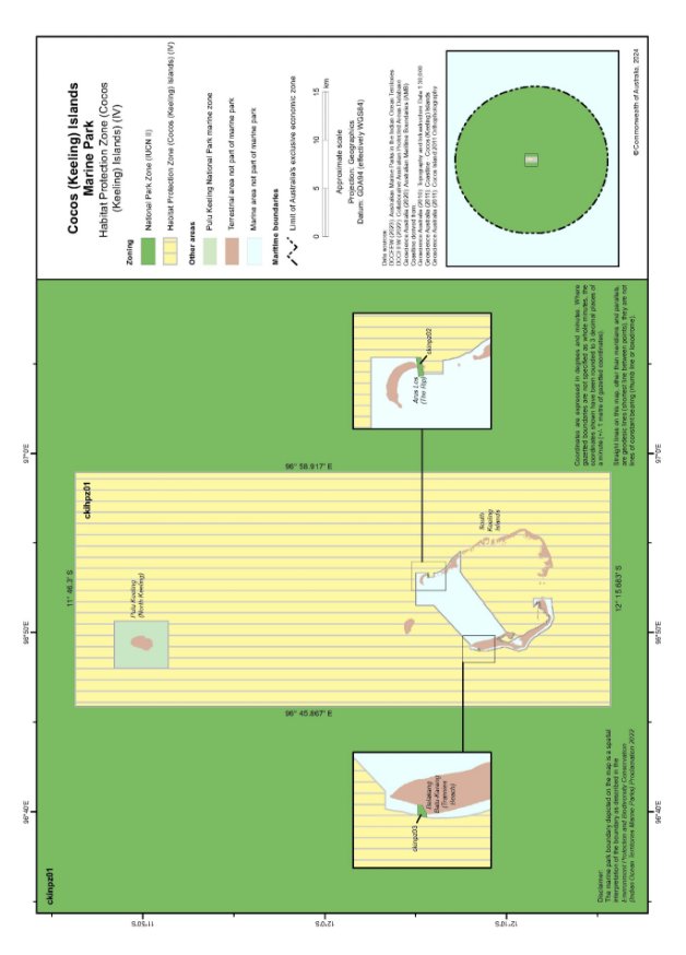
Figure 2.2 Cocos (Keeling) Islands Marine Park Habitat Protection Zone (Cocos (Keeling) Islands) (IUCN IV)
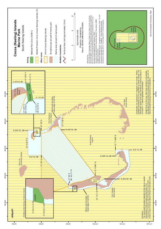
Figure 2.3 Cocos (Keeling) Islands Marine Park and port area
Cocos Malay people, who make up the majority of the Cocos (Keeling) Islands population, are descended from the original inhabitants the predominantly Malay workers who were brought to the islands by European settlers to plant and work coconut plantations, commencing in the 1820s. In 1955, the islands were proclaimed a territory of the Commonwealth, and the Australian Government purchased the title of the islands from the Clunies-Ross family in 1978. In 1984, the Cocos Malay community voted for integration with the Australian mainland in a United Nations supervised Act of Self Determination.
The small community on Cocos (Keeling) Islands has continued to live and work on the islands for over 150 years. The Cocos Malay community primarily resides on Home Island and maintains strong cultural traditions and connections to the surrounding marine environment. For Cocos Malay people, the southern atoll lagoon, with its variety of accessible habitats and species, fringing ocean waters and the passage to North Keeling Island, are key to this connection. These are places to catch food and share the company of family and friends. They are places that have strong stories attached to them and where traditional activities can continue and be passed on to future generations. Many families have pondoks (rustic shacks) on the unpopulated islands of Cocos these pondoks provide connection and access to the marine environment for many islanders.
On the other side of the lagoon is West Island, which is home to a predominantly non-Cocos Malay population of government service workers, businesses and tourism enterprises. For many West Islanders, the sea is also an important part of life. The idyllic waters of the lagoon are the basis of most tourism ventures on the island and a place for residents and visitors alike to relax and spend time with friends and family while fishing, snorkelling, diving, surfing, canoeing or kitesurfing. The marine environment links the entire Cocos community and is a critical connection to the rest of the world in terms of receiving the supplies that it needs.
Fishing may be the most common and strongest link of all between Cocos Islanders and the marine environment it is a pursuit shared across communities, cultures and generations. Someone is always fishing at Cocos. Depending on the weather and the day of the week, you might see small boats heading into the lagoon from Home Island for a catch of bodas (silveries) or belenak (mullet); West Islanders trolling for tuna and other pelagics on the ocean side of the islands; children trying their luck from the beach, rocks or seawalls; visiting groups wading into the shallows of the southern lagoon for the sport of catching and releasing a bandang (bonefish) on a fly rod; Home Islanders collecting gong gong (spider conch) in preparation for a wedding or other occasion; and others keen for adventure heading north of the lagoon into the deep waters between the southern atoll and North Keeling Island.
As the marine environment is important to the local community for many reasons, community engagement in the process to co-design and establish Cocos (Keeling) Islands Marine Park was extensive, with many local people and organisations making strong and constructive contributions. The process to prepare the Cocos (Keeling) Islands Marine Park management plan continued this engagement and collaboration, with goals to protect the environment while supporting local community views and aspirations.
In simple terms, ‘values’ are the things in or about a place that are important to people. Identifying them helps provide focus for park management. To help describe and understand values, it can be helpful to divide them into categories, even though many may overlap these categories. The values categories for Cocos (Keeling) Islands Marine Park are:
Natural values – species and the genetic diversity they contain, habitats, ecological communities, ecosystems, and geological and geomorphological features, and the processes that sustain them.
Cultural values – tangible and intangible aspects of culture that people want to protect, maintain and pass to future generations including knowledge, beliefs, practices, language, traditions, places, objects, collections, stories and oral histories.
Social and economic values – the benefits for people, communities, businesses and the economy.
A summary of the values of Cocos (Keeling) Islands Marine Park is provided below. Values are not static new values may be identified and the relative importance of different values may change over time. The Director will consider the benefits and risks to park values when making management decisions.
Cocos (Keeling) Islands Marine Park supports important habitats for a range of marine species, many of which breed, forage or rest in the park’s waters. The marine park also contains significant features, such as reef systems and seamounts, that are important for biodiversity and ecosystem function and integrity.
Many of these values are found in the inshore waters of Cocos (Keeling) Islands themselves, while others are found in the open ocean and deep offshore waters.
Southern atoll lagoon
The extensive lagoon ecosystem at the southern atoll of Cocos (Keeling) Islands is a key ecological feature in the IOT marine region and in the Indian Ocean more broadly, where systems of this nature are rare. The lagoon covers an area of around 190 km2 and is the predominant shallow-water marine habitat in the IOT. The lagoon provides a diversity of ecosystems and habitat types that support a range of marine species, shallow and deep lagoon ecosystems and intertidal areas (Figure 2.4). Seagrass, macroalgae and coral are important structural organisms providing habitat for benthic communities not found elsewhere in the IOT. Deeper pools and channels such as those at Arus Les (The Rip) and Pulu Maraya provide important fish habitat. The marine park covers the south‑eastern half of the lagoon and the area between North Point on West Island and Horsburgh Island, capturing ecologically representative samples of all habitats in and around the lagoon. The southern atoll lagoon is very important for the ecosystem services it provides for the local community. It is also vulnerable and under pressure. This is discussed below in Section 2.4 (Pressures and drivers in Cocos (Keeling) Islands Marine Park).
Outer reef ecosystems
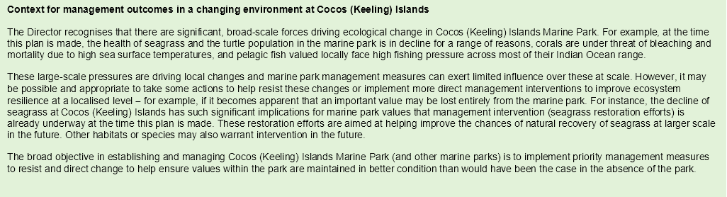
The reef system (outer reef flat, reef crest, reef slope and mesophotic reef) encircling the southern atoll (Figure 2.4) is important for a diversity of species, including hybrid and endemic coral reef fauna, popas bottlenose dan spinner (bottlenose and spinner dolphins), cucut (reef sharks), pareh (manta rays) and benthic organisms, such sponges and other invertebrates. The reef at Belakang Batu-Karang (Trannies Beach) is biodiverse and is of high conservation value. The outer reef is also important for species that are targeted by fishers for example, ikan hijau (humphead Māori wrasse), dongol (bumphead parrotfish), gelek burik (coral trout), udang (painted crayfish) and udang lepeh (slipper lobster), kakap (snappers and emperors), deepwater fishes (for example, cods, jobfishes) and resident pelagic species such as ikan tuna (dogtooth tuna).
The presence of hybrid and endemic coral reef fauna not found anywhere else on earth is of global conservation significance. Their evolution is largely due to their geographic position at the border of 2 marine bioregions, which are subject to a mixing of Indian and Pacific Ocean waters and species.
Reef fish communities
Cocos (Keeling) Islands supports a diverse community of reef fish, reflecting the diverse habitats and the islands’ unique biogeography. Habitats utilised by reef fishes include the inner lagoon, coral bommies, blue holes and the exposed outer reef. Wrasses, gobies, damselfishes and cods are found inhabiting the islands’ reef habitats, including high numbers of ikan hijau (humphead Māori wrasse).
The Cocos (Keeling) Islands marine environment also supports endemic and hybrid fishes, including the Cocos and lemonpeel angelfishes. Six varieties of hybrid reef fish and 2 endemic reef fish have been recorded on the outer reef ecosystems of the islands. High levels of endemism and hybridisation contribute to the islands’ significant biodiversity by creating new genetic combinations which may enhance ecosystem resilience to environmental changes.
Figure 2.4 Southern atoll lagoon and surrounding habitat types
Kolam (blue holes)
The kolam (blue holes) are an ecologically important habitat within the southern atoll lagoon ecosystem. Scattered across the sandy habitats of the lagoon, the blue holes are encircled by coral and contain coral rubble in the centre, providing deeper and more complex habitats. They support cucut (sharks), gong gong (spider conch), gelek burik (coral trout), dongol (bumphead parrotfish) and ikan hijau (humphead Māori wrasse). The southern blue holes in particular provide shelter for invertebrates and juvenile fish at low tide when the shallow southern lagoon flats are exposed. The blue holes are also culturally important to Cocos Malay fishers, who have named each individual kolam and associate different holes with particular species.
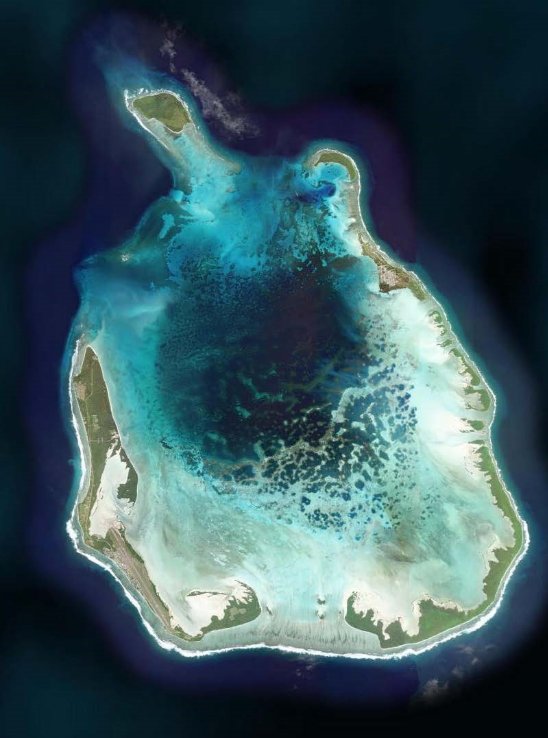
Image: Cocos (Keeling) Islands southern atoll showing the kolam (blue holes) (Esri, Maxar, Earthstar Geographics, and the GIS User Community)
Lumut (seagrass)
Seagrass is a key habitat of the lagoon it is important for many species, including penyu (green and hawksbill turtles), ikan terompet (pipefish), juvenile blacktip anak cucut (reef sharks), rajugan (mud crabs) and gerita (night octopus), and provides nursery habitat for a range of fish species. It is also important for the overall lagoon ecosystem, as it stabilises sediment and filters nutrients functions that help with water quality. Seagrass at Cocos (Keeling) Islands is under significant pressure, with around 80% of seagrass in the southern atoll lagoon estimated to have been lost between 2006 and 2018 due to multiple causes, including high temperature events, sediment disturbance from the development of the Rumah Baru Jetty and increased grazing pressure from turtles (Buckee et al. 2021). Given this concerning decline, at the time this plan is made, Parks Australia is working with partner organisations on seagrass restoration trials in the Cocos lagoon.
Cucut (sharks)
Cucut (sharks), including blacktip, cucut batu (whitetip reef sharks) and cucut itam (grey reef sharks), are common in and around Cocos (Keeling) Islands. Four other shark species have been recorded in the area: the tiger, scalloped hammerhead, pelagic thresher and silky. Sharks play a key role in marine ecosystems by helping to maintain balance in the food chain. The shallow inner lagoon provides important nursery habitat for juvenile blacktip reef sharks and the blue holes provide an important nursery habitat for grey reef sharks.

Image: Grey reef shark (Rohan Newton)
Penyu (marine turtles)
Cocos (Keeling) Islands provides important habitat for internationally significant populations of resident green and hawksbill turtles. Green turtles recruit from a diverse range of rookeries, including Pulu Keeling National Park, the Australian mainland, Indonesia and Malaysia. Hawksbill turtles recruit from rookeries to the west, including the Seychelles and the Chagos Archipelago. Cocos (Keeling) Islands Marine Park, together with Pulu Keeling National Park, captures areas that are important to both green and hawksbill turtles for foraging and resting. The moderate sized rookery at Pulu Keeling supports a unique genetic stock of green turtles that is isolated and has limited genetic transfer with other rookeries in the Indian Ocean. The preferred food of green turtles is seagrass and, in its absence, they rely on seaweed and animal material. Hawksbill turtles have a varied diet often relying on invertebrates, especially sponges supported by seagrass and coral reef habitat. Leatherback, loggerhead and olive ridley turtles are also observed in the waters of Cocos (Keeling) Islands from time to time. Actions under this management plan will contribute to the objectives of the Recovery Plan for Marine Turtles in Australia.
Open ocean ecosystem and seafloor features
The entirety of Cocos (Keeling) Islands’ offshore marine environment more than 400,000 km2 of ocean – is captured within Cocos (Keeling) Islands Marine Park. Within this vast area there are seamounts and seamount chains and a long ridgeline, among other deep-sea features. The variation in depth and seafloor habitat that these features provide supports a diversity of deep‑sea species. Gorgonian fans, seastars, crabs, anemones and many other marine invertebrates exhibiting unique and unusual features can be found in these deep-sea environments. The open ocean pelagic environment also supports a range of species such as oceanic sharks, large pelagic fish like yellowfin tuna, ikan terbang (flying fish) and seabirds. Nine species of cetaceans (whales and dolphins) have been recorded in the marine environment around Cocos (Keeling) Islands.

Figure 2.5 Proposed offshore key ecological features of Cocos (Keeling) Islands Marine Park
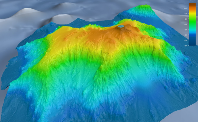
Image: Muirfield Seamount – around 130 km south-west of Cocos (Keeling) Islands (CSIRO) (the coloured area represents the extent of the mapping undertaken by the RV Investigator in 2022)

Image: Tripod fish (Ocean Exploration Trust / NOAA)
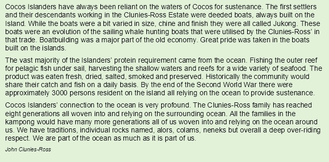
For nearly 2 centuries, Cocos Malay people have continuously relied on the southern atoll lagoon and ocean environment for their livelihood and sustenance. The Cocos Malay people’s interdependence with the marine environment has significantly shaped their way of life and contributed to their unique cultural identity.
Cultural knowledge
The Cocos Malay people’s strong connection to the marine environment is evident through their traditional fishing practices, in which they have harnessed their knowledge of marine life, tides and navigation skills to sustain themselves for generations. Over time, Cocos Malay elders have observed ecological changes in the marine environment. They have valuable insights into the natural features of their environment, providing a useful knowledge base for researchers and Parks Australia. The intergenerational transfer of this knowledge is also highly valued by the Cocos Malay community.

Cocos Malay cultural sites
Specific areas within the marine park hold a cultural importance to members of the Cocos Malay community. One example is the 142 kolam (blue holes) that are individually named in the Cocos Malay language and associated with different species.

Traditions and ceremonies
The marine environment plays a significant role in the Cocos Malay people’s religious beliefs, traditions and ceremonies. It is a cultural tradition to catch and serve ikan hijau (humphead Māori wrasse), gong gong (spider conch), bodas (silveries), belenak (mullet) at Hari Raya (a significant time of celebration and reconciliation for the local Cocos Malay community), weddings and other celebrations.
Another important species that has cultural importance as a food during celebration events is burung maen-maen (red-footed booby). These seabirds were legally harvested up until the late 1990s, when changes to environmental legislation saw the practice outlawed. At the time this plan is made, some members of the Cocos Malay community are keen to reinstitute a sustainable cultural harvest of these birds under current environmental laws. This management plan allows for such a harvest to occur within the marine park should it be approved under those laws (Section 4.3.14 (Red-footed booby (sula sula) harvest)).
Kebudayaan dan perayaan
Satu lagi jenis yang mempunyai kepentingan dalam kebudayaan sebagai makanan dimasa upacara perayaan adalah sula sula (burung maen-maen). Burung lautan ini dahulunya boleh diamek hingga penghujung 1990an bila petukaran undang-undang alam sekitar mulai melarang kebiasaan ini. Berberapa penduduk masyarakat Melayu Cocos sangat maukan untuk mengembalikan kebiasaan untuk mengamek burung dengan cara yang bertahanan menurut undang-undang alam sekitar sekarang — rancangan pengurusan ini mengizinkan untuk pengamekkan sedemikian untuk berlaku dalam taman lautan kalau ianya diluluskan dibawa undang-undang itu.
Maritime skills and traditions
Cocos Malay people built small timber vessels for use in the lagoon during the very early days of settlement and developed world-class boat-building skills and knowledge over time. Boat building was a core need for the remote islands in the years before regular shipping and air travel. Large 19th century ocean-going timber vessels built at Cocos were highly regarded. Small island‑built jukung (jukongs) (keel-less timber sailing vessels) continued to be used for fishing and other purposes around the islands and were commonly sailed all the way to North Keeling Island. While jukongs have been replaced by modern vessels for fishing, the jukong tradition has been passed on to and is maintained today by younger generations weekend morning jukong races off Home Island attract a crowd of spectators and the competition is strong.
Kepandaian dan tradisi belayar
Orang Melayu Cocos membuat kapal kecil untuk digunakan dalam lagun dimasa awal perkampungan bermula dan memajukan kepandaian membuat kapal dan pengetahuan yang bertaraf dunia. Membuat kapal adalah kepentingan yang besar untuk pulu-pulu yang jauh dimasa kapal laot dan penerbangan belom menjadi kebiasaan. Kapal-kapal kayu besar abad ke-19 yang dibina di Cocos dipandang tinggi. Jukong buatan pulau kecil (kapal layar kayu tanpa lunas yang dalam) terus digunakan untuk mancing dan tujuan lain di sekitar pulu dan kadang-kadang belayar hingga ke Pulau Keeling. Tradisi jukong telah diteruskan dan dikekalkan hari ini oleh generasi muda perlumbaan jukong dimasa hari cuti di Home Island menarik ramai penonton dan pertandingannya kuat.
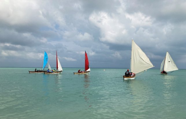
Image: A jukong race departs the Home Island foreshore in calm conditions (Allyn White)
For younger Cocos Malay men, jukung (jukong) racing today provides an important cultural connection with traditional cultural practices of their ancestors and showcases Cocos Malay historical boat-building skills.
Fishing
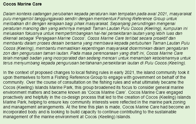
The southern atoll lagoon supports important sources of food that have sustained the community since settlement. Fishing and the communal sharing of food have continued to play an important role in the Cocos Malay culture and lifestyle. Maintaining these practices now and into the future holds considerable value for the Cocos Malay community. The marine park’s yellow zone allows established fishing practices to continue in accordance with fishing rules administered by DITRDCA. Fisheries management arrangements at Cocos (Keeling) Islands include the employment of a local fisheries ranger by the Shire of Cocos (Keeling) Islands, the establishment of Cocos Marine Care (a local fisheries management body) and a ministerially appointed Fisheries Advisory Committee. The membership of Cocos Marine Care and the Fisheries Advisory Committee is drawn from the local community.

Image: Fishing is an important cultural and recreational activity at Cocos (Keeling) Islands
(Justin Gilligan)
Oral histories and stories
The Cocos Malay community has passed down many stories and oral histories through generations which demonstrate its connection to the marine environment. These narratives encompass seafaring expeditions, cultural traditions and experiences of their ancestors, as well as detailed ecological knowledge, such as changes to the marine environment. Oral storytelling helps to preserve and share the Cocos Malay culture, and this ecological knowledge is also an important resource for researching and managing the marine park.

The Cocos (Keeling) Islands marine environment and its natural values support a range of important social and economic uses that underpin the livelihoods and wellbeing of many members of the community.
Recreational activities
The marine environment is a place of recreation and relaxation for most Cocos (Keeling) Islanders, with residents and visitors drawn to the water for fishing, boating, canoeing, sailing, paddleboarding, snorkelling, scuba diving, surfing, kitesurfing and swimming.

Commercial activities
The mainstays of the Cocos (Keeling) Islands economy are the government services and the private businesses that help ensure the critical needs of Cocos (Keeling) Islanders are met. Next to these, tourism is the most significant economic activity on the islands, and the marine environment is key to this. Most commercial tour enterprises are focused on the water and include scuba diving, snorkelling, boating, charter fishing, kitesurfing and windsurfing. These marine tourism businesses help to drive the Cocos (Keeling) Islands visitor economy, with flow-on economic benefits for other businesses in the community.
The marine environment also supports local small-scale commercial fishing involving hand collection of high-value aquarium species for export.
Employment, education and research
Management of marine parks generates opportunities for employment for local people and broader opportunities to be involved in research activities. Cocos (Keeling) Islands Marine Park supports education and research activities for example, education and engagement opportunities for the local school, community members and visitors; and research to identify and protect park values.
The marine park also offers opportunities for nationally and internationally significant research by individuals and research institutions already attracted to Cocos (Keeling) Islands for the uniqueness of its environment.

Wellbeing
The marine environment is a significant contributor to the wellbeing of many members of the Cocos (Keeling) Islands community. In a location where land-based recreation opportunities are more limited than in many other places in Australia, many people look to the sea as a wellbeing outlet. Everyone’s goal or experience from this is unique, but most gain intangible benefits from their interaction with the sea, not just physical ones.

Pressures are events and activities – often human-driven – that may impact negatively on marine park values. Some pressures can be mitigated by management actions, but others, such as those associated with climate change, cannot always be addressed by park management.
Drivers are phenomena which can influence the state or condition of values and benefits and in some cases may also influence pressures. Drivers can be divided into biophysical, and social and economic categories. Biophysical drivers are mostly of natural origin and are not easily influenced by management actions. Examples include natural variations in climate and weather patterns and ocean currents and tides. Social and economic drivers are usually of human origin. Some management actions can have an influence over a subset of social and economic drivers, such as promoting environmental awareness or compliance with regulations.
Key pressures on Cocos (Keeling) Islands Marine Park are outlined below. Chapter 3 outlines a range of programs and actions that will be taken to address pressures and Chapter 4 outlines how different activities will be managed in the marine park in the context of these pressures. However, the Director also recognises that management actions will need to adjust to changes in pressures and drivers over time to ensure optimal protection of the marine park and its values.
The impacts of climate change on the marine environment are complex and may include longer lasting marine heatwaves, continued rise in sea level, further ocean acidification, changes to ocean currents, altered storm frequency and intensity and species range extensions or local extinctions. These multifaceted changes have the potential to significantly impact on marine park values. Moreover, climate changes will intricately interact with and amplify many non-climate threats to marine park values.
The marine park values in the southern atoll lagoon in particular are under pressure from sustained and ongoing changes in environmental conditions, partly influenced by anthropogenic climate change, including changes in hydrological and wind regimes that drive circulation, sedimentation and lagoon infilling and subsequently the water quality in the lagoon. Historically, the lagoon has been subject to multiple ‘die-off’ events, with major effects on fish, invertebrates, corals, lumut (seagrasses) and macroalgae. These events generally coincide with extended periods of warm temperatures and calm, westerly wind conditions, resulting in reduced flushing, elevated water temperatures and reduced dissolved oxygen in the southern lagoon and blue holes areas. When dissolved oxygen levels become critically low, organisms begin to die, which causes further oxygen reduction and mortality. Some die-off events are associated with coral spawning and can occur naturally. However, if the conditions which lead to die-off events become more frequent and severe as a consequence of climate change, it is likely that mass die-off events within the lagoon will increase in their frequency and severity.
Warmer water temperatures and extreme heat events also have potential to bleach coral in Cocos (Keeling) Islands Marine Park, and this pressure is predicted to increase into the future. Physical features and microclimates, which provide short-term refuges and longer term refugia for some climate‑sensitive species, will play an important role in protecting species. Seagrass and coral, primary habitat-forming species in the lagoon and coral reef ecosystems, are particularly vulnerable to climate change. If habitats and ecosystems are damaged, this can have ripple effects on species dependent on these, such as reef fish and sharks.
The marine park is likely to undergo ecological changes as a result of climate change. For example, coral bleaching could reduce the amount of suitable habitat for species to occupy. Highly mobile species ranges are likely to expand as they track their climatic preferences in search of suitable habitats, causing an increased likelihood of non-native and marine invasive species entering the Cocos (Keeling) Islands marine environment. This may lead to variations in species abundance, distribution and diversity, resulting in changes in food chain interactions and potential shifts in the community structure within marine environments. The isolation of Cocos (Keeling) Islands will also limit species’ ability to move ranges in line with their climatic preferences, increasing the likelihood of local extinctions. The timing and intensity of natural events, including cyclones and storms, may be altered, affecting the marine environment’s ability to recover through changes in demography and regeneration. These environmental changes could have flow-on effects for the cultural, social and economic values of the marine park by affecting populations of culturally significant species, impacting cultural fishing traditions or causing declines in ecosystems that are popular attractions for tourists and valued by the community.
Cocos (Keeling) Islands faces the imminent threat of sea-level rise and intensified erosive processes due to heightened rainfall, increased temperatures and extreme weather events, including storms and cyclones. Cyclones and storms can cause significant loss of coral cover. Inundation of Cocos (Keeling) Islands will have implications for the water quality and health of the lagoon and threatens the cultural and socio-economic activities tied to these remote islands.
Changes to the marine environment will create challenges for management and the wellbeing and livelihoods of Cocos (Keeling) Islands residents, visitors and other users. Flexible and adaptable management approaches will be adopted in order to respond to shifting and potentially unpredictable conditions, to help ensure the marine environment is protected in the most effective way possible.
The Director acknowledges that climate change threatens much more than the marine environment at Cocos (Keeling) Islands it also threatens the islands themselves and the communities that live there. The Director will seek to support the work of other government agencies with primary responsibility for managing local climate change impacts.
Marine debris, such as general plastic waste, microplastics, ‘ghost nets’ (lost or discarded fishing nets), fish aggregating devices and other pollution, such as discharge of oil and chemicals, can affect water quality and can stem from sea- or land‑based activities. Cocos (Keeling) Islands’ location along major ocean currents and proximity to Australia’s northern neighbours makes it prone to substantial amounts of marine debris, especially plastic waste. Exposed ocean-facing beaches and rocky shorelines are local accumulation hotspots for marine debris. This debris threatens marine life and ecosystems through entanglement, disturbance of nesting habitats, ingestion and exposure to harmful pollutants and can act as a vector for marine invasive species. Marine debris can also affect the social and economic values of the marine park by diminishing the islands’ aesthetic appeal.
With most marine debris originating in other countries, there is little that small communities or marine park managers can do to prevent this debris arriving. Considerable efforts are made – mainly by volunteers – to remove this debris when it arrives. There are also efforts to ensure locally generated waste is managed well and does not enter the environment. The Australian Government more broadly is making efforts through direct engagement with neighbouring countries and through joining international efforts to develop a global plastics treaty. Actions under this management plan will support efforts to manage marine debris and contribute to the objectives of the Threat Abatement Plan for the Impacts of Marine Debris on the Vertebrate Wildlife of Australia’s Coasts and Oceans (2018).
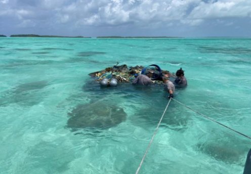
Image: Volunteers and Parks Australia work to remove marine debris in the southern atoll lagoon (Parks Australia / Sea Shepherd)
Linked to climate change, coastal development and marine pollution as well as natural processes, water quality in the southern atoll lagoon has deteriorated over the 20 years preceding the development of this management plan. Poor water quality can affect key species such as seagrass and corals, whose loss can contribute to further deterioration in water quality. Water quality and its associated drivers have been and are likely to continue to be major factors in the health of seagrass at the southern atoll and the broader lagoon ecosystem. Water quality monitoring and, where possible, work with other relevant authorities to improve water quality will be a focus for management of the marine park under this plan.
Marine invasive species present an ongoing threat to marine biodiversity. Potential sources of marine invasive species include climate-driven range changes, vessel ballast and bilge water discharge, vessel biofouling and accidental or deliberate transport of species. The introduction of new species and environmental stressors can also cause disease outbreaks affecting corals and other species. Given the islands’ proximity to high-risk areas in South‑East Asia and isolated nature, marine invasive species pose a significant threat to the marine park’s unique biodiversity, as well as to marine industries and amenity. As a First Point of Entry under the Biosecurity Act 2015 (Cth), the Cocos (Keeling) Islands Port is subject to biosecurity controls under this Act, which are administered by the Commonwealth Department of Agriculture, Fisheries and Forestry.
Islands, reefs and other shallow-water ecosystems are vulnerable to marine invasive species. Invasives can impact native species directly through predation or by damaging important habitats; and indirectly through competition for habitats and food. At the time this plan is made, no marine invasive species have established themselves in the Cocos (Keeling) Islands marine environment and a regular marine invasive species monitoring program is in place.
Coastal development and infrastructure on Cocos (Keeling) Islands helps to provide services critical to the islands and their people. For example, Cocos (Keeling) Islands is reliant on the port for the shipment of supplies, including, food, fuel and other necessities; and the seawalls of Home Island and West Island are essential for mitigating the impacts of storms, tides and climate change. The critical nature of this infrastructure is recognised in the marine park’s design the seawalls and active port area were not incorporated into the marine park to provide regulatory certainty for the island’s critical marine and coastal infrastructure operations. Even though these areas are not part of the marine park, Parks Australia will liaise with other agencies and authorities in relation to any developments that may have impacts on the marine park to ensure these are minimised to the extent practical.
Generally, coastal development and infrastructure require careful management to avoid impacts on the marine environment. Impacts on habitat in marine parks can occur directly though the physical removal or harm of species and habitats; or indirectly through reduction in light availability, smothering habitats or disturbance of animals in the vicinity as a result of increased sedimentation suspension and depositions from infrastructure. Parks Australia will carefully assess any proposals for coastal development and infrastructure activities within the marine park.
As discussed above, fishing is a significant part of life on Cocos (Keeling) Islands, and many residents rely on fish to meet their nutritional needs.
The southern atoll lagoon environment is unique within the eastern Indian Ocean and vulnerable to pressures, including fishing. To help ensure local fishing pressure is managed, recreational fishing rules have been developed through a community‑led process under DITRDCA, which is responsible for fisheries management at Cocos (Keeling) Islands. These fishing rules support the sustainability of island-based fishing activities. As is the case for other Australian marine parks, the inshore yellow Habitat Protection Zone (IV) allows recreational fishing that complies with the local fishing rules.
Fishing, including illegal, unregulated and unreported fishing, can modify natural populations of target species. Bycatch of non-target species and/or physical disturbance to habitats can result from certain fishing methods and may therefore impact on marine park values. The green National Park Zoning of the offshore waters of the marine park mean that no fishing of any kind is permitted across this large expanse of ocean. However, illegal fishing by foreign fishing vessels is a risk to the marine park, as the offshore waters surrounding Australia’s Exclusive Economic Zone in the Indo-Pacific are heavily targeted by international fleets. Partnerships with other government agencies with sea and air patrol compliance capability help Parks Australia to manage this risk.
Many Cocos (Keeling) Islands residents and visitors venture into the marine environment for activities such as beach and reef walking, boating, surfing, kitesurfing, diving, snorkelling and swimming. There are also a small number of tour operators, who offer scuba diving, snorkelling, kayaking and fishing experiences. While enjoying the marine environment, it is important to be aware of the potential impacts of increased human presence on the natural behaviour of wildlife and habitats, particularly in high-use areas such as Arus Les (The Rip), Pulu Maraya and the Coal Barge. Activities such as boating, fishing, diving and snorkelling have the potential to impact marine park values directly through direct contact with marine life or indirectly through changes in behaviour. Human presence may result in changes to wildlife behaviour such as nesting, breeding, feeding and resting or may damage fragile reef marine environments. Examples of habitats and species vulnerable to human disturbance include reef habitats, penyu (marine turtles) and cucut (sharks).
Activities understood to change the behaviour of wildlife in ways that can have negative impacts
(such as shark feeding) may require monitoring and management responses under this plan.
Pulu Keeling National Park covers the entirety of the remote and largely untouched North Keeling Island. The park also extends into the marine environment around 1.5 km seaward from the island’s shore, protecting the fringing reef.
Cocos (Keeling) Islands Marine Park surrounds and adjoins the marine zone of Pulu Keeling National Park (Figure 2.6), integrating this long-established national park into a wider seascape protection system. Providing contiguous protection across marine and terrestrial environments is important for the seabirds, turtles and other species that rely on both of these environments to survive. Parks Australia will work to ensure management of both parks is streamlined and integrated for the benefit of park users and other stakeholders and to enhance the effectiveness of management activities.

Image: Burung maen-maen (red-footed booby) (sula sula) chicks resting in Pulu Keeling National Park (Matthew Anderson)
The Director will need to make decisions about what activities can occur in the marine parks and the actions to manage them. This will involve the Director making decisions that carefully balance the need to protect natural, cultural and social and economic values of marine parks with enabling use and managing pressures.
In making these decisions, the Director will carefully consider the impacts and risks to natural, cultural and social and economic values for Cocos (Keeling) Islands Marine Park. The Director will also consider any positive impacts associated with allowing an activity and ensure that activities are undertaken in a manner that minimises negative impacts. Some examples of the types of values and pressures the Director may consider in their decision making are outlined in Section 2.3 (Values of Cocos (Keeling) Islands Marine Park) and Section 2.4 (Pressures and drivers in Cocos (Keeling) Islands Marine Park).
As understanding of marine park values improves, the Director may make new information about values and pressures available on the Parks Australia website.

Figure 2.6 Cocos (Keeling) Islands Marine Park and Pulu Keeling National Park boundary
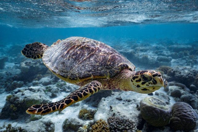
Image: Hawksbill turtle (Rohan Newton)
The Director will act to protect Cocos (Keeling) Islands Marine Park from pressures, minimise damage to values and improve the resilience of the marine environment. The programs and actions set out in Table 3.1 may need to be adapted as new information and approaches become available. This will occur in consultation with the community advisory committee and other stakeholders.
The desired outcomes set out in Table 3.1 indicate where the Director will focus monitoring efforts and what impacts are sought from management actions.
Table 3.1 Management programs, goals, outcomes and actions
Vision | Healthy and thriving marine environments for future generations |
Objectives | - To protect and conserve biodiversity and other natural and cultural values
- To provide for ecologically sustainable use that supports positive social and economic outcomes
|
Management programs | Science, monitoring and management effectiveness | Protection, resilience and adaptation | Visitor use and communication | Community and stakeholder benefits and engagement |
Goal | Improve understanding of marine species, habitats and ecosystems and associated pressures, resilience and changes | Reduce pressures and the impacts of environmental changes on marine species, habitats and ecosystems | Enhance visitor appreciation, understanding and sustainable use of the park | Engage with and support social and economic benefits for the community and stakeholders |
Desired outcomes | - Seagrass cover increases in the lagoon.
- Diverse corals continue to inhabit the outer reef, southern blue holes and lagoon ecosystems and support characteristic species.
- Green and hawksbill turtles are healthy and continue to inhabit the lagoon and outer reef of the marine park.
- Pelagic species diversity and abundance is maintained or increases.
- No new marine invasive species establish.
- Diversity of reef fish communities is maintained.
- There are low levels of inshore compliance incidents.
- The number of incursions of foreign fishing vessels remains steady or decreases.
- Community satisfaction with the management of the marine park is maintained.
- Awareness and understanding of the marine park increases among visitors to Cocos (Keeling) Islands and park users.
- Fishing experiences in the marine park are maintained or improved.
- The local community is supported to maintain marine cultural knowledge.
- Research, monitoring and restoration effort in the marine park is directed to areas of high management priority – e.g. ecosystem pressures, changes and causes of change.
- The marine park contributes to sustainable economic activity at Cocos (Keeling) Islands.
|
Actions | - Conduct and enable research and monitoring to improve understanding of:
- park values and associated pressures
- impacts of climate change and adaptation measures
- current and future ecosystem changes and how to enhance resilience.
- Develop ecosystem restoration and recovery methodologies for ecosystems under pressure.
- Monitor the condition and trend of priority values and pressures.
- Evaluate and report on the effectiveness of management actions to inform adaptive management.
- Develop and maintain data and information management systems, processes and reporting to support evidence-based park management.
- Continue to build and maintain collaborative and cost-effective partnerships to deliver quality science.
| - Regulate activities within the marine park, including by:
- assessing activity proposals in accordance with management plan prescriptions
- conducting surveillance and compliance operations in partnership with other agencies.
- Implement management actions to help:
- protect species, habitats, ecosystems and biodiversity under pressure
- enhance ecosystem resilience and adaptation in response to a changing climate and other environmental changes
- minimise pressures through engagement and collaboration with other management agencies.
- Monitor and manage marine invasive species.
- Monitor and support management of lagoon water quality.
- Prepare for a range of critical incidents and support maritime emergency agencies to respond to events.
- Support the collaborative management of marine debris.
- Explore effective approaches to ecosystem restoration and adaptation.
| - Communicate information about park values and management to visitors and park users.
- Educate visitors and park users about the marine park rules and sustainable practices.
- Support activities that enhance and promote sustainable, rewarding and safe recreational and tourism experiences.
| - Establish and maintain a marine park advisory committee.
- Engage and build the capacity of the community and local groups/organisations to support the management of the park.
- Develop and implement environmental educational programs for the local school.
- Establish and maintain partnerships and collaborative arrangements with key stakeholders.
- Support the collection and documentation of cultural and historical knowledge of the marine environment.
- Encourage the sharing of findings from research and monitoring work with island communities and other stakeholders.
- Liaise with other agencies and authorities on developments that may help improve waste management at Cocos (Keeling) Islands.
|
The Director, in consultation with the Cocos (Keeling) Islands Marine Park advisory committee and other relevant stakeholders and experts, will monitor, evaluate and report on the implementation of this plan. This will include:
Monitoring, evaluation and reporting will ensure park managers, the Cocos (Keeling) Islands Marine Park community advisory committee and other stakeholders have access to relevant information about park and management performance in line with the points outlined above. Specific arrangements will be developed in consultation with the advisory committee, stakeholders and experts and seek to complement the Director’s annual corporate planning and performance reporting requirements.
In the final 2 years of the management plan, a review will be undertaken to evaluate the effectiveness of the implementation of this plan and inform the next Cocos (Keeling) Islands Marine Park management plan.
A Cocos (Keeling) Islands based advisory committee was established to support the preparation of this management plan and advise on management activities following the marine park’s proclamation. A new Cocos (Keeling) Islands Marine Park advisory committee will be established under this plan to advise Parks Australia on the implementation of this plan. Cocos (Keeling) Islands community members will form the majority of the committee’s membership, with external scientific and other experts to be drawn in as needed.
Broadly, the role of the advisory committee will be to support Parks Australia’s management of the marine park by providing advice on:
- implementation of this management plan and associated management programs and actions
- community and park user views, knowledge and needs
- monitoring, evaluation and reporting in accordance with Section 3.2 (Monitoring, evaluation
and reporting).
Terms of reference, including membership details, for the committee will be finalised in consultation with stakeholders. Consultation will include consideration of how best to align community advisory arrangements in relation to both Cocos (Keeling) Islands Marine Park and Pulu Keeling National Park (any arrangements involving Pulu Keeling National Park would need to be consistent with the lease granted to the Director by the Cocos (Keeling) Islands community for North Keeling Island and its surrounding waters).
Committee meetings will be held at least twice per calendar year, and Parks Australia will provide the committee with documents and reports on the implementation of management programs and other material as appropriate to ensure the committee has the information necessary to fulfil its functions.

Image: Burung cuit-cuit (white tern) (Siddiq Juljali)
Zoning and related prescriptions for managing activities are important tools for managing marine parks to ensure protection of marine habitats and species, while supporting the continuation of important activities in the marine environment. In determining the zones and prescriptions, the Director has considered the best available science, the views and aspirations of the Cocos (Keeling) Islands community, advice from stakeholders, comments from the general public, the goals and principles of the National Representative System of Marine Protected Areas and the IUCN reserve management principles.
The EPBC Act requires this plan to assign an IUCN category to the marine park. The EPBC Act also allows this plan to divide a marine park into zones and to assign a category to each zone. The category for each zone may differ from the overall category of the marine park.
This section assigns an IUCN category to Cocos (Keeling) Islands Marine Park and sets out the objectives for each zone. The zoning of Cocos (Keeling) Islands Marine Park that is assigned under this plan is the same as the zoning that was assigned at the time the park was proclaimed in 2022. The maps in Chapter 2 show the zones assigned to Cocos (Keeling) Islands Marine Park.
Prescriptions
- Cocos (Keeling) Islands Marine Park is assigned overall to the IUCN category II and the following zones:
- National Park Zones (IUCN II), as shown in Section 2.1, Figure 2.1; and
- Habitat Protection Zone (Cocos (Keeling) Islands) (IUCN IV), as shown in Section 2.1, Figure 2.2.
- The objective of the National Park Zones (IUCN II) is to provide for the protection and conservation of ecosystems, habitats and native species in as natural a state as possible.
- The objectives of the Habitat Protection Zone (Cocos (Keeling) Islands) (IUCN IV) are to:
- provide for the conservation of ecosystems, habitats and native species, while allowing activities that do not harm seafloor habitats;
- support cultural, social and economic activity in the marine park that aligns with the views and aspirations of the Cocos (Keeling) Islands community.
This plan enables a range of activities to be carried out that would otherwise be prohibited or controlled by the EPBC Act and EPBC Regulations. This chapter sets out for Cocos (Keeling) Islands Marine Park which activities are:
- allowed: the activity can be carried out without the need for separate authorisation, where consistent with IUCN zone objectives and conducted in accordance with this chapter;
- allowable: the activity is able to be carried out if a separate authorisation is issued (Section 4.5 (Authorisation of allowable activities)); or
- not allowed: the activity is prohibited because it is not consistent with zone objectives.
For those activities that are allowed or allowable, this chapter also sets out:
- the assessment and decision-making process for authorising an activity (Section 4.4 (Making decisions about activities));
- the types of authorisations that may be issued (permits, class approvals, activity licences and leases) (Section 4.5 (Authorisation of allowable activities)); and
- how activities must be undertaken in Cocos (Keeling) Islands Marine Park (Section 4.3 (Prescriptions for activities)).
Other provisions of the EPBC Act or other legislation (for example, fishing rules) may also apply to an allowed or allowable activity.
This plan enables activities to be conducted in zones consistent with the zone objectives while enabling the impacts to be effectively managed. Rules for these activities are summarised in Table 4.1 and the detailed activity prescriptions are provided in Sections 4.3.1 to 4.3.14.
Table 4.1 Summary of prescriptions for activities in Cocos (Keeling) Islands Marine Park
Activity | Habitat Protection Zone (Cocos (Keeling) Islands) (IV) | National Park Zone (II) |
GENERAL USE AND ACCESS (Section 4.3.1) | Overnight stays on vessels | | |
Recreational use (nature watching, boating, walking, swimming etc.) | | a |
COMMERCIAL SHIPPING (Section 4.3.2) | Anchoring | b | X |
Transiting | | a |
COMMERCIAL FISHING (Section 4.3.3) | Dropline | A | X |
Hand collection (including using hookah, scuba, snorkel) | A | X |
Hand net (hand, barrier, skimmer, cast, scoop, drag, lift) | A | X |
Menjala (set net) | A | X |
Longline (demersal, auto-longline) | X | X |
Longline (pelagic) | A | X |
Minor line (handline, rod and reel, trolling, squid jig, poling) | A | X |
Net (demersal) | X | X |
Net (pelagic) | A | X |
Purse seine | A | X |
Bubuk (trap, pot) | A | X |
Trawl (demersal) | X | X |
Trawl (mid-water) | A | X |
Trotline | X | X |
COMMERCIAL AQUACULTURE (Section 4.3.4) | Aquaculture | A | X |
COMMERCIAL MEDIA (Section 4.3.5) | Media | A | A |
COMMERCIAL TOURISM (Section 4.3.6) | Non-fishing related tourism (including nature watching, scuba/snorkel tours) | A | Aa |
Charter fishing (including spearfishing) | A | X |
RECREATIONAL FISHING (Section 4.3.7) | Recreational fishing (including spearfishing) | | X |
MINING (Section 4.3.8) | Mining and similar or related activities (including oil and gas operations, seabed mineral mining, greenhouse gas storage, pipelines and exploration) | X | X |
STRUCTURES AND WORKS (Section 4.3.9) | Excavation, erection/maintenance of structures, works | A | A |
Artificial reefs | A | A |
Fish aggregating devices | A | X |
RESEARCH, MONITORING AND RESTORATION (Section 4.3.10) | Research, monitoring and restoration | A | A |
NATIONAL SECURITY AND EMERGENCY RESPONSE (Section 4.3.11) | National security and emergency response | | |
WASTE MANAGEMENT (Section 4.3.12) | Ballast water discharge and exchange (compliant with Australian ballast water requirements) | | |
Disposal of waste from normal operations of vessels (compliant with the MARPOL requirements as they exist at the commencement of this plan) | | |
NON-COMMERCIAL REMOTELY PILOTED AIRCRAFT (DRONES) (Section 4.3.13) | Non-commercial remote piloted aircraft, drones etc. | | |
RED FOOTED BOOBY (SULA SULA) HARVEST (Section 4.3.14) | Cultural harvest of burung maen-maen (red‑footed booby) | A | X |
– Activity is allowed in accordance with the prescriptions of this plan without separate authorisation by the Director.
X – Activity is not allowed.
A – Authorisation required. Activity is allowable, subject to assessment, in accordance with a permit, class approval or activity licence or lease issued by the Director (and other laws where applicable). Refer to Section 4.4 – Making decisions about activities and Section 4.5 – Authorisation of allowable activities.
a Motor and wind-powered vessels are not permitted in the National Park Zones at Arus Les (The Rip) and Belakang Batu-Karang (Trannies Beach).
b Anchoring is not allowed except in anchoring areas determined under regulation 12.56 of the EPBC Regulations. However, note that anchoring as part of most other activities under this plan (for example, recreational fishing) is allowed in the Habitat Protection Zone.
The prescriptions in this section set out the requirements for general use and access to Cocos (Keeling) Islands Marine Park and apply to all users of the park. The prescriptions are summarised in Table 4.1.
When accessing Cocos (Keeling) Islands Marine Park for any purpose, general care should be taken to avoid or minimise any damage to the marine environment. For example, wherever possible, touching or anchoring on corals should be avoided.
Prescriptions
- General recreational access to the marine park is allowed – for example, for the purposes of swimming, snorkelling, scuba diving, boating, nature watching, kitesurfing, kayaking, windsurfing, paddleboarding and walking in intertidal areas subject to the following:
- Fishing is not allowed in green National Park Zones (IUCN II) and elsewhere is subject to the prescriptions provided in Sections 4.3.7 (Recreational fishing) and 4.3.3 (Commercial fishing).
- Motor and wind-powered vessels are not permitted in the 2 nearshore National Park Zones (IUCN II) at Arus Les (The Rip) and Belakang Batu-Karang (Trannies Beach) (unless to assist persons in distress).
- Marine life, including corals, must not be touched, stood on or otherwise disturbed in green National Park Zones (IUCN II).
- Overnight stays on vessels are allowed.
- The operation of a motor vehicle is allowed in the yellow Habitat Protection Zone (Cocos (Keeling) Islands) (IUCN IV) for the purpose of launching or retrieving vessels.
- The Director may issue an authorisation for an activity that would otherwise be prohibited, restricted or the subject of a determination under the EPBC Regulations.
- The prescriptions in this section apply to all users of Cocos (Keeling) Islands Marine Park, including those carrying out other activities provided for in this plan.
The prescriptions in this section set out the requirements for commercial shipping in Cocos (Keeling) Islands Marine Park.
Australia is a party to a number of international agreements relevant to commercial shipping in particular, the United Nations Convention on the Law of the Sea (UNCLOS) and the International Convention for the Prevention of Pollution from Ships (MARPOL). UNCLOS provides a right of innocent passage through the territorial sea for foreign vessels and a right of freedom of navigation through Australia’s Exclusive Economic Zone. This section places some limits on the exercise of these rights in some zones. The limitations are necessary to protect marine park values, apply to all commercial shipping and are consistent with Australia’s rights and obligations under UNCLOS.
There are also a range of national laws, policies and procedures relevant to commercial shipping that continue to apply within the marine park. These include the National Plan for Maritime Environmental Emergencies in relation to maritime pollution incidents, and the Biosecurity Act 2015 (Cth) and the associated Australian ballast water management requirements and the Australian biofouling management requirements. Prescriptions dealing with waste disposal and ballast water discharge and exchange are in Section 4.3.12 (Waste management).
Prescriptions
4.3.2.1 Commercial ships, including those undertaking other activities in accordance with this plan, may transit in Cocos (Keeling) Islands Marine Park.
4.3.2.2 With the exception of Section 4.3.8 (Mining), persons conducting an activity in accordance with this plan under Sections 4.3.3 to 4.3.14 may anchor in the yellow Habitat Protection Zone (Cocos (Keeling) Islands). Other commercial ships may anchor only in areas determined as anchoring areas by a determination made by the Director under regulation 12.56 of the EPBC Regulations.
Note: This section does not prevent anchoring in any area of Cocos (Keeling) Islands Marine Park due to circumstances of distress or other unforeseen circumstances beyond the vessel’s control or for the purpose of rendering assistance to persons, ships or aircraft in danger or distress.
The prescriptions in this section set out the requirements for commercial fishing activities in Cocos (Keeling) Islands Marine Park, including the types of fishing gear and methods allowed. These are summarised in Table 4.1.
A key requirement is that commercial fishing in Cocos (Keeling) Islands Marine Park must be in accordance with a commercial fishing concession from the relevant fisheries management authority. The Director will prepare a class approval to facilitate the continuation of existing (at the time this plan is made) commercial fishing operations in the yellow Habitat Protection Zone (Cocos (Keeling) Islands).
Research in connection with commercial fishing activities will be managed in accordance with Section 4.3.10 (Research, monitoring and restoration).
Prescriptions
- Commercial fishing is not allowed in the green National Park Zones.
- Commercial fishing activities may be conducted in the yellow Habitat Protection Zone (Cocos (Keeling) Islands) in accordance with and subject to any determinations made by the Director under regulation 12.34 of the EPBC Regulations, and:
- a permit issued under Section 4.5.1 (Permits); or
- a class approval issued under Section 4.5.2 (Class approvals); or
- an activity licence issued under Section 4.5.3 (Activity licences and leases) to a person who is not covered by a class approval.
- Commercial fishing activities must be conducted in accordance with a commercial fishing concession issued under Commonwealth, state or territory fisheries laws to the extent those laws are capable of operating concurrently with this plan.
- The Director requires the views of the community advisory committee to be considered by the responsible fisheries management authority before any significant new commercial fishing activities (for example, fishing with the methods of purse seine, pelagic longline or mid‑water trawl) can occur in Cocos (Keeling) Islands Marine Park.
- The following fishing gear must not be used in Cocos (Keeling) Islands Marine Park, and, if carried onboard a commercial fishing vessel, must be kept stowed and secured at all times while in Cocos (Keeling) Islands Marine Park:
- longline (demersal, auto-longline);
- net (demersal), noting that this does not include menjala (set nets);
- trawl (demersal); and
- trotline.
- Fishing gear or methods not specified in a commercial fishing class approval or activity licence, or its conditions, must not be used.
- When transiting in the green offshore National Park Zone, all gear associated with commercial fishing operations must be stowed and secured.
The prescriptions in this section set out the requirements for commercial aquaculture in Cocos (Keeling) Islands Marine Park.
A key requirement is that commercial aquaculture in Cocos (Keeling) Islands Marine Park must be in accordance with other applicable laws for example, provisions of the EPBC Act and marine resources management laws.
Prescriptions
- Commercial aquaculture is not allowed in the green National Park Zones.
- Commercial aquaculture may be conducted in the yellow Habitat Protection Zone (Cocos (Keeling) Islands), in accordance with and subject to:
- a permit issued under Section 4.5.1 (Permits); or
- a class approval issued under Section 4.5.2 (Class approvals); or
- an activity licence issued under Section 4.5.3 (Activity licences and leases) to a person who is not covered by a class approval.
- Aquaculture activities must be conducted in accordance with an approval issued under Commonwealth, state or territory marine resource management laws, including biosecurity laws, to the extent those laws are capable of operating concurrently with this plan.
- The Director requires the views of the community advisory committee to be considered by the responsible marine resources management authority before any new aquaculture activities can occur in the marine park.
- When transiting in the green offshore National Park Zone, all gear associated with aquaculture operations must be stowed and secured.
The prescriptions in this section set out the requirements for commercial media in Cocos (Keeling) Islands Marine Park. The prescriptions are summarised in Table 4.1.
Prescriptions
- Commercial media activities may be conducted in Cocos (Keeling) Islands Marine Park in accordance with and subject to:
- a permit issued under Section 4.5.1 (Permits); or
- a class approval issued under Section 4.5.2 (Class approvals); or
- an activity licence issued under Section 4.5.3 (Activity licences and leases).
- Commercial media activities for the purposes of reporting news of the day may be undertaken without an authorisation. However, persons undertaking news of the day reporting must comply with any written or verbal directions issued by the Director in relation to the conduct of those activities.
At the time this plan is made, commercial marine tourism at Cocos (Keeling) Islands is small scale, with a limited number of operators. Constraints on visitor numbers, such as limited visitor accommodation, are likely to see marine tourism at Cocos (Keeling) Islands remain a small-scale, low-impact industry of high relative value to the local economy. In this context the Director will establish a class approval under this management plan with fit-for-purpose conditions for small-scale, local marine tourism operators. Operators not covered by the class approval may seek individual authorisation via a permit, or activity licence or lease.
The prescriptions in this section set out the requirements for commercial tourism in Cocos (Keeling) Islands Marine Park.
Prescriptions
- Commercial tourism activities may be conducted in Cocos (Keeling) Islands Marine Park in accordance with and subject to:
- a class approval issued under Section 4.5.2 (Class approvals); or
- a permit issued under Section 4.5.1 (Permits); or
- an activity licence or lease issued under Section 4.5.3 (Activity licences and leases).
- Commercial tourism activities that involve recreational fishing must also comply with the prescriptions in Section 4.3.7 (Recreational fishing).
- Motor and wind-powered vessels are not permitted in the inshore green National Park zones known as Arus Les (The Rip) and Belakang Batu-Karang (Trannies Beach).
The prescriptions in this section set out the requirements for recreational fishing in Cocos (Keeling) Islands Marine Park. The prescriptions have the effect of applying the Cocos (Keeling) Islands recreational fishing rules within the yellow Habitat Protection Zone of Cocos (Keeling) Islands Marine Park.
Research in connection with recreational fishing will be managed in accordance with Section 4.3.10 (Research, monitoring and restoration).
Prescriptions
- Recreational fishing is not allowed in the green National Park Zones.
- Recreational fishing (including spearfishing) is allowed in the yellow Habitat Protection Zone in accordance with and subject to:
- the laws governing recreational fishing at Cocos (Keeling) Islands (to the extent those laws are capable of operating concurrently with this plan); and
- any determinations made under regulation 12.35 of the EPBC Regulations.
Mining and similar or related activities are not allowed in Cocos (Keeling) Islands Marine Park.
Prescriptions
4.3.8.1 Mining and activities that are related to mining are not allowed in Cocos (Keeling) Islands Marine Park. This includes, but is not limited to:
- oil and gas mining;
- mineral seabed mining;
- greenhouse gas storage;
- construction and operation of pipelines; and
- exploration (including seismic testing).
4.3.8.2 Vessels involved in mining may transit through Cocos (Keeling) Islands Marine Park.
The prescriptions in this section set out the requirements for structures and works in Cocos (Keeling) Islands Marine Park, where the activity is not covered by Sections 4.3.1 to 4.3.8.
Research in connection with structures and works will be managed in accordance with Section 4.3.10 (Research, monitoring and restoration).
Note: Structures may include, but are not limited to, moorings, submarine cables, platforms (including any artificial structure at sea, whether floating or fixed to the seabed, but not including a vessel), jetties, seawalls and other infrastructure.
Prescriptions
4.3.9.1 Excavations, erecting a structure or other works, including maintenance of structures and associated activities, may only occur in Cocos (Keeling) Islands Marine Park in accordance with and subject to:
- a permit issued under Section 4.5.1 (Permits); or
- a class approval issued under Section 4.5.2 (Class approvals); or
- an activity licence or lease issued under Section 4.5.3 (Activity licences and leases).
4.3.9.2 Works activities may be carried out in Cocos (Keeling) Islands Marine Park where it is not practicable for the action to be taken outside the marine park, and the action has been assessed as necessary for:
- maritime or visitor safety, including aiding navigation; or
- maintaining the values of Cocos (Keeling) Islands Marine Park; or
- critical infrastructure; or
- research, monitoring and restoration; or
- commercial tourism.
4.3.9.3 Dredging and disposal of dredged material in the Habitat Protection Zone may only occur where the action has been assessed as necessary for:
- maritime or visitor safety, including aiding navigation;
- maintaining the values of Cocos (Keeling) Islands Marine Park; or
- critical infrastructure.
4.3.9.4 Artificial reefs may only be authorised in Cocos (Keeling) Islands Marine Park to assist the protection, conservation or restoration of habitats and in accordance with and subject to a permit under the Environment Protection (Sea Dumping) Act 1981 (Cth).
4.3.9.5 Works for the purposes of maintaining the existing (at the time this plan is made) seawall and associated infrastructure at Belakang Batu-Karang (Trannies Beach) are allowed without further authorisation from the Director.
4.3.9.6 Fish aggregating devices (FADs) may be installed in the Habitat Protection Zone in accordance with and subject to an authorisation issued under Section 4.5 (Authorisation of allowable activities).
4.3.9.7 The Director will consult with the community advisory committee as part of their assessment of any application for a permit or licence to install a FAD.
The prescriptions in this section set out the requirements for research, monitoring and restoration activities in Cocos (Keeling) Islands Marine Park.
Research, monitoring and restoration activities may also be subject to the provisions of Part 13 of the EPBC Act (research involving listed species) and Part 8A of the EPBC Regulations (research relating to biological resources).
Prescriptions
- The Director may conduct research, monitoring and restoration activities in Cocos (Keeling) Islands Marine Park that involve actions covered by sections 354 and 354A and Part 13 of the EPBC Act.
- A person other than the Director may conduct research, monitoring and restoration activities in Cocos (Keeling) Islands Marine Park, including taking actions that would otherwise be prohibited under sections 354 and 354A and Part 13 the EPBC Act, only in accordance with and subject to:
- a permit issued under Section 4.5.1 (Permits);
- a class approval issued under Section 4.5.2 (Class approvals); or
- an activity licence or lease issued under Section 4.5.3 (Activity licences and leases).
- Research activities that involve access to biological resources within the meaning of Part 8A of the EPBC Regulations must also comply with the requirements of that Part (in addition to the requirements of this section).
- The Director will require authorisation holders to make results of research, monitoring and restoration activities available to the Director, stakeholders and/or the general public (in a specific format where relevant).
- The Director will require activity proponents to consult with relevant stakeholders including individuals and organisations on Cocos (Keeling) Islands prior to and during the conduct of their activity, where the Director considers this appropriate.
- The clean-up of general marine debris (for example, plastic waste at sea or that has washed up on the shoreline) is allowed in Cocos (Keeling) Islands Marine Park and does not require a further authorisation.
The prescriptions in this section set out the requirements for defence, border protection, law enforcement and emergency response activities in Cocos (Keeling) Islands Marine Park.
Provisions of the EPBC Act and EPBC Regulations (Division 12.2) relating to Australian marine parks generally apply to the Commonwealth and its agencies. In addition, section 362(2) of the EPBC Act requires the Commonwealth and Commonwealth agencies to perform functions and exercise powers in relation to Australian marine parks in a way that is not inconsistent with this plan. The Director will build on existing partnerships with Commonwealth agencies, including under the National Plan for Maritime Environmental Emergencies.
Prescriptions
- Actions by or under direction of the Commonwealth and Commonwealth agencies in Cocos (Keeling) Islands Marine Park that are otherwise prohibited by sections 354 and 354A and Part 13 of the EPBC Act and covered by Division 12.2 of the EPBC Regulations are:
- allowed for the purposes of training and operations for defence, customs, border protection, law enforcement or emergency response and may be conducted without the need for a permit or class approval; and
- allowable for purposes other than those in (a), above, in accordance with a permit or class approval issued by the Director in accordance with Section 4.5 (Authorisation of allowable activities).
The prescriptions in this section set out the requirements for waste management activities in Cocos (Keeling) Islands Marine Park.
Waste from normal operations of vessels must be compliant with requirements under MARPOL the International Maritime Organization convention covering prevention of pollution of the marine environment by ships from operational or accidental causes (as those requirements exist at the commencement of this management plan). Ballast water discharge and exchange must be compliant with ballast water management requirements administered by other government agencies.
Prescriptions
- Disposal of domestic and industrial waste may be carried out in accordance with and subject to:
- a permit issued under Section 4.5.1 (Permits);
- a class approval issued under Section 4.5.2 (Class approvals); or
- an activity licence issued under Section 4.5.3 (Activity licences and leases); and
- relevant determinations made under regulation 12.14B of the EPBC Regulations.
Note: At the commencement of this plan a determination is in place under the EPBC Regulations that provides for the disposal of wastewater and desalination by-product from island-based treatment plants and the disposal of vessels in accordance with other applicable environmental laws. This determination supports the operation of critical island infrastructure, acknowledging the significant challenges faced in remote locations with respect to waste disposal; and supports the operations of other Australian Government agencies that help to address pressures on the marine park, such as illegal, unreported and unregulated foreign fishing.
- Waste from normal operations may be disposed of from vessels to which MARPOL applies, in accordance with the requirements of MARPOL (as those requirements exist at the commencement of this plan).
- Disposal of waste in connection with activities authorised under Section 4.3.9 (Structures and works) will be managed in accordance with that section.
- Ballast water may be discharged or exchanged subject to compliance with:
- the Biosecurity Act 2015 (Cth); and
- other relevant Commonwealth and state legislation or international agreements relevant to ballast water management.
- The prescriptions in this section apply to all users of Cocos (Keeling) Islands Marine Park, including those carrying out other activities provided for in this plan.
Note: Ballast water exchange should be conducted in at least 200 nm from nearest land and in waters 200 m deep. For voyages that cannot practically meet these requirements, ballast water exchange must occur at least 12 nm from the nearest land and in water at least 50 m deep.
The prescriptions in this section set out the requirements for the operation of non‑commercial remotely piloted aircraft (drones) in Cocos (Keeling) Islands Marine Park.
Prescriptions
4.3.13.1 Remotely piloted aircraft (drones) may be operated in all zones of Cocos (Keeling) Islands Marine Park for non‑commercial purposes without further authorisation from the Director, in accordance with and subject to:
- applicable aviation safety laws as administered by the Civil Aviation Safety Authority;
- relevant provisions of Part 8 of the EPBC Regulations relating to whale watching and other interactions with cetaceans;
- other Commonwealth and state legislation relevant to remotely piloted aircraft; and
- any relevant determinations made under the EPBC Regulations.
4.3.13.2 Pilots of remotely piloted aircraft must ensure that their aircraft:
- does not approach birds from higher than a 60‑degree angle or at speeds exceeding 3 m per second;
- is launched and operated as far as practicable from groups of seabirds and nesting seabirds;
- is immediately landed if wildlife exhibit signs of disturbance for example, fleeing, sudden alteration of a course or direction, attacking the remotely piloted aircraft (drone) or being put to flight.
Sula sula were legally harvested by members of the Cocos Malay community up until the late 1990s, when changes to environmental legislation saw the practice outlawed. Some members of the Cocos Malay community want to reinstitute a sustainable cultural harvest of these birds under current environmental laws. This management plan allows for such a harvest to occur within Cocos (Keeling) Islands Marine Park should it be approved under those laws.
Masyarakat Melayu Cocos dahulunya dibebaskan untuk mengamek burung maen-maen hingga penghujung 1990an bila petukaran undang-undang alam sekitar mulai melarang kebiasaan ini. Berberapa penduduk masyarakat Melayu Cocos sangat maukan untuk mengembalikan kebiasaan untuk mengamek burung dengan cara yang bertahanan menurut undang-undang alam sekitar sekarang rancangan pengurusan ini mengizinkan untuk pengamekkan sedemikian untuk berlaku dalam taman lautan kalau ianya diluluskan dibawa undang-undang itu.
Prescriptions
4.3.14.1. Should a harvest of sula sula be approved under the EPBC Act and/or other relevant laws, that harvest may proceed in accordance with the conditions of that approval in Cocos (Keeling) Islands Marine Park without the need for a permit, class approval or other authorisation from the Director.
Sekiranya pengamekkan burung maen-maen diluluskan menurut Akta EPBC/atau perundangan lain yang berkenaan dimasa penghidupan plan ini, pengamekkan burung boleh dijalankan menurut syarat-syarat yang dinyatakan dalam kelulusan yang diberikan dalam taman lautan tanpa keperluan sebuah permit, kelulusan kelas atau kebenaran daripada Director.
Many activities that could potentially occur in Cocos (Keeling) Islands Marine Park are not directly addressed in Chapter 4 of this plan but are the subject of rules under the EPBC Regulations. A list of some such activities potentially relevant to Cocos (Keeling) Islands Marine Park is provided in Table 4.2. In broad terms, these activities are prohibited by the EPBC Regulations unless otherwise allowed under this plan or the EPBC Regulations.
Table 4.2 Summary of EPBC Regulations for park users to be aware of
Activity | Relevant EPBC regulation(s) |
Damage and defacing natural features, objects, signs or structures | 12.12 |
Damage to heritage | 12.13 |
Dumping of industrial waste | 12.14 |
Dumping of domestic waste | 12.14A |
Use of poisonous substances | 12.15 |
Use of firearms, fireworks and other weapons and devices. However, note that there are provisions in the regulations to allow transport of such items through the marine park | 12.18 |
Taking animals (except assistance animals for use by a person with a disability) and plants into the park and cultivating plants | 12.19, 12.20, 12.21 |
Interfering with a native species. However, note provisions in this plan allowing fishing and approved seabird harvest activities | 12.19B |
Adventurous activities (e.g. hang gliding, paragliding, rock climbing, abseiling, bungee jumping, BASE jumping) | 12.26 |
Public nuisance – devices that produce loud noise | 12.27 |
Burials. However, note the scattering of ashes at sea does not constitute burial at sea for the purposes of the Environment Protection (Sea Dumping) Act 1981 | 12.32 |
The EPBC Regulations also provide the Director with a range of powers to address park management issues that may arise from time to time for example, the Director can prohibit or restrict access to an area of Cocos (Keeling) Islands Marine Park under regulation 12.23 of the EPBC Regulations.
New activities may be required or proposed in Cocos (Keeling) Islands Marine Park that are not covered by the prescriptions in this plan. The prescriptions in this section enable the Director to consider and authorise new activities in Cocos (Keeling) Islands Marine Park. They also enable the Director to authorise activities in new ways that are identified to be more efficient and effective.
Prescriptions
- The Director may take actions that are not covered by specific prescriptions in this plan, including actions otherwise prohibited or restricted by sections 354 and 354A of the EPBC Act (for example, keeping or moving a member of a native species).
- The Director may authorise (by a permit, class approval, activity licence or lease under Section 4.5 (Authorisation of allowable activities)) actions that are not covered by prescriptions in this plan, including actions covered by sections 354 and 354A of the EPBC Act and the EPBC Regulations.
- The Director may issue permits, class approvals, activity licences or leases, or other usage rights in place of existing authorisations under this plan.
The prescriptions in this section outline the approach and considerations of the Director when making decisions about what activities will be authorised in Cocos (Keeling) Islands Marine Park.
Prescriptions
- Decisions about activities will:
- consider the potential impacts, risks and benefits to the values of Cocos (Keeling) Islands Marine Park as set out in Section 2.3 of this plan, marine parks users and stakeholders; and
- be consistent with the objectives of Cocos (Keeling) Islands Marine Park as set out in Section 3.1 of this plan, objectives of the zone or zones in which the activity will be or is being carried out, and the applicable Australian IUCN reserve management principles as set out in Schedule 8 of the EPBC Regulations.
- Before authorising a proposed activity, the Director must be satisfied that:
- potential impacts on and risks to the values of Cocos (Keeling) Islands Marine Park will be avoided or reduced to as low as reasonably practicable;
- the proponent has consulted or will consult appropriately with stakeholders, including relevant representatives of the Cocos (Keeling) Islands community;
Note: The Director will provide guidance for proponents on what constitutes appropriate consultation where requested.
- the proponent has the capacity to comply with the conditions of the authorisation; and
- relevant regulatory requirements have been or will be met.
Prescriptions
- For the purposes of Section 4.4.1 (Decision making), the Director may consider the assessment of proposed activities made under Chapter 4 of the EPBC Act or the Environment Protection (Sea Dumping) Act 1981 or under a government or industry policy, plan, or program.
The prescriptions in this section outline the processes for seeking a review of a decision. A person whose interests are affected by a decision by the Director under this plan, including a decision about an authorisation, may seek review under the Administrative Review Tribunal Act 2024 (Cth) and in accordance with the review process set out in Division 14.3 of the EPBC Regulations.
Without limiting the operation of the EPBC Regulations, a person may only apply to the Administrative Review Tribunal for the review of the Director’s reconsideration of a decision under this plan.
This plan extends the same review rights to decisions on all authorisations made by the Director under this plan. Where the Director issues a class approval for an activity, review is limited to the making of the class approval.
Prescriptions
4.4.3.1 The process for reconsideration of a Director’s decision about a permit under Section 4.5.1 is provided for in regulation 14.3 of the EPBC Regulations.
4.4.3.2 The process for reconsideration in regulation 14.3 of the EPBC Regulations applies to any decision of the Director under Section 4.5 of this plan, including decisions about class approvals (Section 4.5.2) and activity licences and leases (Section 4.5.3).
4.4.3.3 Without limiting the operation of regulation 14.3 of the EPBC Regulations, the person requesting the reconsideration must:
- have their interest affected by the decision and be dissatisfied with the decision;
- provide written notice to the Director, asking the Director to reconsider the decision, within 21 days after the decision first comes to the notice of the person; and
- set out in the written notice the reasons for making the request.
4.4.3.4 The Director will follow the process in regulation 14.3 of the EPBC Regulations when reconsidering a decision made under Section 4.5 of this management plan.
4.4.3.5 A person may apply to the Administrative Appeals Tribunal for the review of the Director’s reconsideration decision.
The Director may authorise allowable activities through a permit, class approval, activity licence or lease in accordance with this chapter. The prescriptions in this section describe those types of authorisations, the processes and consideration for issuing them, and the conditions that may be imposed by the Director.
A permit can be issued to authorise a person or persons to conduct an allowable activity for example, an activity that is one-off, time bound and/or not generally conducted in a similar way.
Prescriptions
- A permit may be issued for an allowable activity where prescribed by Section 4.3 (Prescriptions for activities) of this plan, in accordance with Part 17 of the EPBC Regulations, subject to the prescriptions (if any) relating to the particular activity.
- In assessing a permit application, the Director may ask the applicant for more information if the Director considers there is insufficient information to decide whether to issue the permit.
- A permit may be subject to conditions including but not limited to (and depending on the type of activity):
- specifying the area in which, and the periods during which, the approved activity may be conducted;
- requiring the impacts of the permitted activity to be mitigated by specified actions developed in consultation with the Director;
- consultation with relevant Cocos (Keeling) Islands community members and/or organisations;
- the provision of, or consent for access to, data for compliance and monitoring purposes;
- making results of data collection, research and monitoring available to the Director (and in a specific format where relevant) and relevant stakeholders;
- requiring reporting or auditing;
- complying with other Commonwealth, state or territory laws and authorisations issued under such laws;
- allowing for the Director or representative to board vessels, accompany tours or enter premises for the purpose of evaluating compliance with permit conditions; and
- requiring, restricting or prohibiting the use of specified gear, equipment or practices.
- A permit may be suspended or cancelled, and permit conditions may be varied or revoked, in accordance with Part 17 of the EPBC Regulations.
This plan provides for the Director to issue class approvals to authorise activities by a specified person or class of persons where the activities are generally done in the same way by persons conducting the activity. This can include, but is not limited to, activities that have been authorised under Chapter 4 of the EPBC Act or the Environment Protection (Sea Dumping) Act 1981 or assessed and authorised under other government or industry processes. Class approvals will be published on the Parks Australia website.
Issuing class approvals can reduce regulatory burden by avoiding duplication in assessment and approval processes and would be introduced in consultation with the relevant person or class of persons.
Prescriptions
- The Director may issue a class approval for activities where prescribed by Section 4.3 (Prescriptions for activities).
- A class approval may be subject to conditions including but not limited to (and depending on the class of activities):
- specifying the area in which, and the periods during which, the approved activity or class of activities may be conducted;
- requiring the impacts of the authorised activity to be mitigated by specified actions developed in consultation with the Director;
- consultation with relevant Cocos (Keeling) Islands community members and/or organisations;
- the provision of, or consent for access to, data for compliance and monitoring purposes;
- making results of data collection, research and monitoring available to the Director (and in a specific format where relevant) and relevant stakeholders;
- requiring reporting or auditing;
- complying with other Commonwealth, state or territory laws and authorisations issued under such laws;
- requiring, restricting or prohibiting the use of specified gear, equipment or practices; and
- allowing for the Director or representative to board vessels, accompany tours or enter premises for the purpose of evaluating compliance with class approval conditions.
- A class approval may be varied, suspended or cancelled, and approval conditions may be varied or revoked, or further conditions applied by the Director. Generally, such a decision will be made in response to new information relevant to the activity and in consultation with the relevant person or class of persons.
- Class approval conditions may be varied or revoked, or have further conditions applied, if the Director is satisfied that it is necessary or appropriate to do so for the efficient or effective management of the activities to which the approval relates.
- A class approval may be varied to remove a person from the class of approved persons at the request of that person or if the Director is satisfied that the person has breached a condition of the approval.
Note: Where a person has been removed from a class approval, they may apply for a permit under Section 4.5.1 (Permits) or an activity licence under Section 4.5.3 (Activity licences and leases).
An activity licence or lease may be issued to authorise an activity where it is more appropriate than the use of a permit or class approval, such as for activities that involve the installation of infrastructure for the exclusive use of a commercial operation. Licences and leases are transferable and generally granted for a longer term than permits. They may include agreed fees reflecting the commercial value of the authorisation and, in the case of leases, provide security of tenure over an area to support investment in infrastructure.
Prescriptions
- An activity licence or lease may be granted where prescribed by Section 4.3 (Prescriptions for activities), subject to the prescriptions (if any) relating to the activity.
- An activity licence or lease may be subject to conditions including but not limited to:
- specifying the area in which, and the periods during which, the authorised activity may be conducted;
- requiring the impacts of the authorised activity to be prevented or mitigated by specified actions developed in consultation with the Director;
- consultation with relevant Cocos (Keeling) Islands community members and/or organisations;
- the provision of, or consent for access to, data for compliance and monitoring purposes;
- making results of data collection, research and monitoring available to the Director (and in a specific format where relevant) and relevant stakeholders;
- requiring reporting or auditing;
- complying with other Commonwealth, state or territory laws and authorisations issued under such laws;
- requiring, restricting or prohibiting the use of specified gear, equipment or practices;
- allowing for the Director or representative to board vessels, accompany tours or enter premises for the purpose of evaluating compliance with licence conditions; and
- providing for the payment of fees.
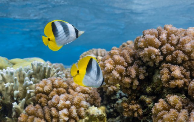
Image: Butterfly fish (Rohan Newton)
This plan takes into account Australia’s obligations and commitments under international agreements that are relevant to Cocos (Keeling) Islands Marine Park. These include:
- Agreement between the Government of Australia and the Government of Japan for the Protection of Migratory Birds and Birds in Danger of Extinction and their Environment (JAMBA)
- Agreement between the Government of Australia and the Government of the People’s Republic of China for the Protection of Migratory Birds and their Environment (CAMBA)
- Agreement between the Government of Australia and the Government of the Republic of Korea for the Protection of Migratory Birds 2007 (ROKAMBA)
- Agreement on the Conservation of Albatrosses and Petrels (ACAP)
- Convention on Biological Diversity (CBD)
- Convention on International Trade in Endangered Species of Wild Fauna and Flora (CITES)
- Convention on the Conservation of Migratory Species of Wild Animals (Bonn Convention)
- Indian Ocean-South-East Asian Marine Turtle Memorandum of Understanding
- International Convention for the Control and Management of Ships’ Ballast Water and Sediments
- International Convention for the Prevention of Pollution from Ships (MARPOL)
- International Convention for the Regulation of Whaling
- Kunming-Montreal Global Biodiversity Framework
- United Nations Convention on the Law of the Sea (UNCLOS)
- 1996 Protocol to the Convention on the Prevention of Marine Pollution by Dumping of Wastes and Other Matter 1972 (the London Protocol)
- 2030 Agenda for Sustainable Development and the Sustainable Development Goals (2030 Agenda).
Image: Manta ray (Rohan Newton)
Brewer DT, Potter A, Skewes TD, Lyne V, Andersen J, Davies C, Taranto T, Heap AD, Murphy NE, Rochester WA, Fuller M & Donovan A 2009, Conservation values in Commonwealth waters of the Christmas and Cocos (Keeling) Island remote Australian territories, CSIRO, https://australianmarineparks.gov.au/static/98f067cbf389235a7e47a068f686771a/amp-document-conservation-christmas-cocos.pdf, accessed 4 December 2024.
Buckee J, Hetzel Y, Nyegaard M, Evans S, Whiting S, Scott S, Ayvazian S, Keulen MV & Verduin J 2021, Catastrophic loss of tropical seagrass habitats at the Cocos (Keeling) Islands due to multiple stressors, vol. 170, no. 112602.
Director of National Parks 2021a, Director of National Parks report on public comments received on the draft proposal for the establishment of marine parks in Australia’s Indian Ocean Territories, Department of Climate Change Energy Environment and Water, https://api.parksaustralia.gov.au/sites/default/files/2022-11/document/amp-document-AMP-IOT-Report-on-draft-proposal-consultation-FA-Oct2021.pdf, accessed 4 December 2024.
Director of National Parks 2021b, Proclamation proposal for the establishment of marine parks in Australia’s Indian Ocean Territories (Cocos (Keeling) Islands and Christmas Island), Department of Climate Change, Energy, the Environment and Water, https://api.parksaustralia.gov.au/sites/default/files/2022-11/document/amp-document-AMP-Proclamation-Proposal-for-the-establishment-of-marine-parks-in-IOTs-Consultation-Paper-October-2021.pdf, accessed 4 December 2024.
Director of National Parks 2021c, Summary of initial community consultation on marine environment values and considerations, Department of Climate Change, Energy, the Environment and Water, https://parksaustralia.gov.au/marine/pub/iot/AMP-IOT-Report-on-draft-proposal-consultation-FA-Oct2021.pdf, accessed 28 June 2024.
Department of the Environment and Energy (DEE) 2017, Recovery Plan for Marine Turtles in Australia, DEE, https://www.agriculture.gov.au/sites/default/files/documents/recovery-plan-marine-turtles-2017.pdf, accessed 5 November 2024.
Department of the Environment and Energy (DEE) 2018, Threat Abatement Plan for the Impact of Marine Debris on the Vertebrate wildlife of Australia’s Coasts and Oceans, DEE, https://www.dcceew.gov.au/sites/default/files/documents/tap-marine-debris-2018.pdf, accessed 1 November 2024.
O’Hara TD 2023, An assessment of the offshore marine natural values of Australia’s Indian Ocean Territories, Museum Victoria, https://api.parksaustralia.gov.au/sites/default/files/2023-06/document/ohara-2023-iot-offshore-natural-values-final.pdf, accessed 4 December 2024.
O’Hara TD 2023, Proposed offshore key ecological features and biologically important areas of Australia’s Indian Ocean Territories, Museum Victoria, https://api.parksaustralia.gov.au/sites/default/files/2023-06/document/ohara-2023-proposed-offshore-iot-kef-bias-v3.02-final-for-publication.pdf, accessed 4 December 2024.
Pratchett M 2021, Natural values of inshore waters of Australia’s Indian Ocean Territories – Christmas & the Cocos (Keeling) Islands, James Cook University, Qld, https://api.parksaustralia.gov.au/sites/default/files/2022-11/document/amp-document-iot-natural-values-report-final-jan-2022.pdf, accessed 4 December 2024.
Travaille KT, Hobbs JP, Davies H, Pratchett M, Clohessy S & Brown K 2023, Conservation Action Plan for the Southern Atoll of the Cocos (Keeling) Islands, Sea Country Solutions, Canberra, Australia, https://australianmarineparks.gov.au/static/724e435c4a418e142e49fda77c3c2b5d/cki-conservation-action-plan.pdf, accessed 4 December 2024.

Figure S2.1 National Park IUCN II Arus Les (The Rip) boundary at Direction Island Cocos (Keeling)
Islands Marine Park
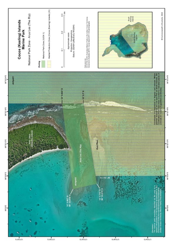
Figure S2.2 National Park Zone (IUCN II) Arus Les (The Rip)

Figure S2.3 National Park (IUCN II) Belakang Batu-Karang (Trannies Beach)

Figure S2.4 Satellite imagery of the National Park IUCN II (Belakang Batu-Karang) (Trannies Beach)
boundary in Cocos (Keeling) Islands Marine Park
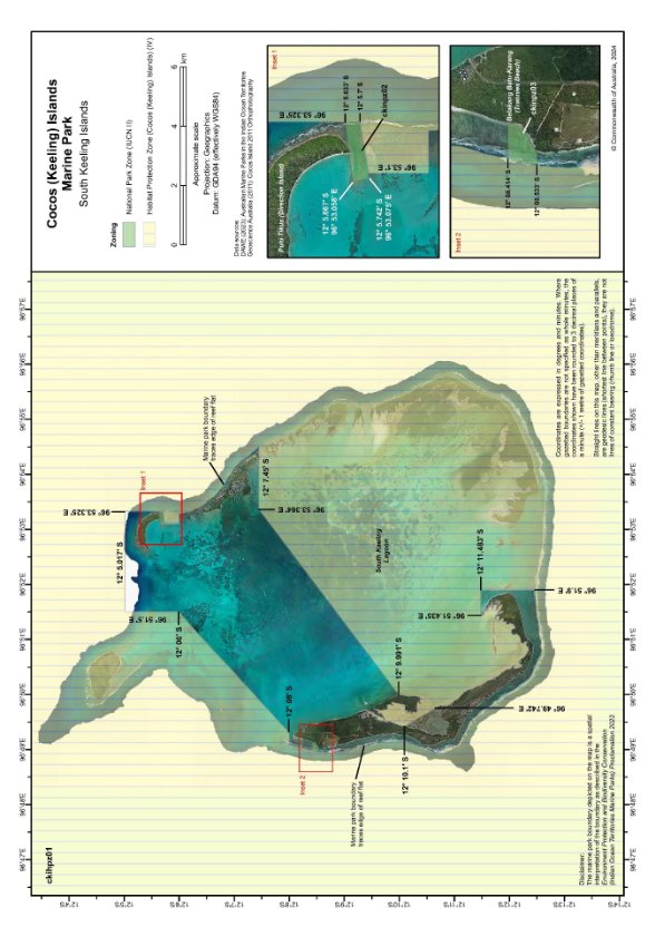
S2.5 Cocos (Keeling) Islands Marine Park – southern atoll
adaptive management | A systematic process for continual improvement of management practices that involves ongoing monitoring of management actions, evaluating their effectiveness in achieving stated objectives and adjusting management accordingly. |
artificial reef | Has the meaning given by the Environment Protection (Sea Dumping) Act 1981 (Cth) namely, a structure or formation placed on the seabed: (a) for the purpose of increasing or concentrating populations of marine plants and animals; or (b) for the purpose of being used in human recreational activities. |
Australian IUCN reserve management principles | The EPBC Act (section 348) requires the EPBC Regulations to prescribe principles for each IUCN category. These principles are the Australian IUCN reserve management principles and are found in Schedule 8 of the EPBC Act. |
Australian marine parks | Commonwealth Reserves, named as marine parks, declared by the Governor‑General by Proclamation under section 344 of the EPBC Act. |
authorisation | As described in Section 4.5 (Authorisation of allowable activities) of this plan. |
ballast water | Water taken on board by vessels to maintain stability and trim. |
biodiversity or biological diversity | Has the meaning given by section 528 of the EPBC Act. |
bioregion | A large area that has similar types of plants, animals and ocean conditions compared with other similarly sized areas and, in this document, those bioregions as defined in the Integrated Marine and Coastal Regionalisation of Australia Version 4.0. |
class approval | As described in Section 4.5.2 (Class approvals) of this plan. |
commercial aquaculture | Farming and culturing of aquatic organisms, such as fish, crustaceans and molluscs. |
commercial fishing | Has the meaning given by section 390SC(1A) of the EPBC Act: a fishing activity that is engaged in for a commercial purpose and, to avoid doubt, does not include an activity that constitutes recreational fishing. |
Commonwealth marine area | Has the meaning given by section 24 of the EPBC Act. |
Commonwealth Reserve | A reserve established and managed under Division 4 of Part 15 of the EPBC Act, including an Australian marine park. |
Director of National Parks (Director) | Established under section 514A of the EPBC Act, including any person to whom the Director has delegated powers and functions under the EPBC Act in relation to Cocos (Keeling) Islands Marine Park. |
dropline | A line that is vertically set or suspended in the water column between a weight (normally in contact with the seabed) and a vessel or a buoy on the water surface. Baited hooks are attached to the mainline via smaller lines (branch‑lines or snoods). |
ecologically sustainable use | Has the meaning given by section 528 of the EPBC Act. |
ecosystem | Has the meaning given by section 528 of the EPBC Act. |
endemic | Native to or confined to a certain region. |
environment | Has the meaning given by section 528 of the EPBC Act. |
Exclusive Economic Zone (EEZ) | Marine area beyond the territorial sea over which Australia has sovereign rights for the purpose of exploring and exploiting, conserving and managing all natural resources. |
fish aggregating device (FAD) | Has the meaning given by the Sea Installation Act 1987 (Cth), namely: (a) a man‑made structure that, when in, or brought into, physical contact with the seabed or when floating, is used solely for the purpose of attracting populations of fish so as to facilitate the taking of those fish; or (b) any electronic or other equipment designed or intended to be ancillary to, or associated with, such a structure while it is being used, or in order to facilitate the use of the structure, for that purpose. The definition does not include a net, trap or other equipment for taking, catching or capturing fish. |
hand collection | Removing species from rocks, crevices, the seafloor or other benthic substrate by hand using dive hookah, self-contained underwater breathing apparatus (scuba) or snorkel. |
hand net (hand, barrier, skimmer, cast, scoop, drag, lift) | A small mesh net that is operated by hand to trap fish, such as a hand net, barrier net, skimmer net, cast net, scoop net, drag net or lift net. |
International Maritime Organization (IMO) | The United Nations specialised agency with responsibility for the safety and security of shipping and the prevention of marine and atmospheric pollution by ships. |
International Union for the Conservation of Nature (IUCN) | A membership union comprising government and non-government organisations, with the goal of conserving the environment. |
marine invasive species | Species moved to an area outside their natural range, generally by human activities, and that threaten the environment, human health or economic values. |
key ecological feature | Elements of the Commonwealth marine environment that, based on best available scientific understanding, are considered to be of regional importance for either the region’s biodiversity or its ecosystem function and integrity. |
longline (demersal, auto-longline) | A line that is horizontally set along the seafloor between weights to maintain contact with the seafloor. The main line has a vertical line attached at each end which is connected to buoys on the water surface. Baited hooks are attached to the main line via smaller lines (branch-lines or snoods). An auto-longline is a longline where the hooks are baited by a machine rather than manually. |
longline (pelagic) | A line that is horizontally set near the surface of the water and avoids contact with the seafloor. The main line has a vertical line attached at each end which is connected to buoys on the surface of the water. Baited hooks are attached to the main line via smaller lines (branch-lines or snoods). Buoys are generally used intermittently along the main line to help maintain buoyancy in the water column. The line may be left to drift in the water or be anchored by vertical lines to the seafloor. |
MARPOL | The International Convention for the Prevention of Pollution from Ships. MARPOL is the International Maritime Organization (IMO) convention covering prevention of pollution of the marine environment by ships from operational or accidental causes. This is the main international convention for the prevention of ship-sourced pollution in the marine environment. MARPOL addresses pollution that might result from accidents such as collisions or groundings, as well as all types of waste generated during the normal operation of a ship. Ships are permitted to discharge small quantities of certain wastes, subject to very strict controls. Any reference to MARPOL is a reference to MARPOL as it existed at the commencement of this management plan. |
Minister | The Minister responsible for administering the EPBC Act. |
minor line (handline, rod and reel, trolling, squid jig, poling) | Any line fishing with a small number of hooks, often just one (i.e. handline, rod and reel, squid jigging and pole fishing). Trolling is dragging a lure or baited hook behind a moving vessel and reeling it in (by hand, reel or winches). Poling is dragging a lure or baited hook on a fixed length of line behind a vessel and flicking or gaffing the fish into the boat. Squid jigging involves vertical lines with several barbless lures being mechanically jigged up and down to attract squid. |
National Representative System of Marine Protected Areas (NRSMPA) | Australia’s comprehensive, adequate and representative system of marine protected areas that contributes to the long-term ecological viability of marine and estuarine systems, maintains ecological processes and systems and protects Australia’s biological diversity at all levels. |
net (demersal) | A rectangular mesh net anchored to the seafloor with weights. The net may have small floats along the upper line to maintain its shape in the water. Each end has a vertical line that is connected to buoys on the surface of the water. |
net (pelagic) | A rectangular mesh net set near the surface of the water that is not in contact with the seafloor. The net generally has floats along the upper line to maintain buoyancy. Each end is connected to a buoy on the surface of the water. The net can be left to drift or connected to a boat. |
news of the day reporting | Contemporary reporting in relation to an unanticipated event that has occurred in or adjacent to the park. |
Parks Australia | The Division in the Department of Climate Change, Energy, the Environment and Water that supports the Director of National Parks to deliver its responsibilities. |
pelagic | Open water. |
permit | As described in Section 4.5.1 (Permits) of this plan. |
prescription | Mandatory requirements for activities in Cocos (Keeling) Islands Marine Park. |
pressures | As described in Section 2.4 of this plan. |
protected species | Species listed under the EPBC Act as threatened, migratory or marine species and/or cetaceans (whales, dolphins and porpoises). |
purse seine | A semi-rectangular mesh net with floats along the top and a weighted line along the bottom. A vessel or buoy is used to anchor one end of the net while it is set around a fish aggregation in a circular pattern. The bottom of the net has a cable threaded through it which, when pulled, brings the bottom of the net together like a purse trapping the fish inside. The net is then pulled toward the vessel and the fish are either lifted or pumped onboard the vessel. |
Ramsar Convention | The Convention on Wetlands of International Importance. The Ramsar Convention was signed in Ramsar, Iran, in 1971. The convention aims to halt the worldwide loss of wetlands and to conserve, through wise use and management, those that remain. |
recreational fishing | Taking marine species, including shells, not for commercial purposes and to avoid doubt, does not include an activity that constitutes commercial fishing. |
stowed and secured | All fishing apparatus, including nets and lines, are rendered inoperative in zones where fishing is not permitted, including that the apparatus is inboard the vessel and otherwise completely out of the water or as determined by the Director. |
set net (menjala) | A length of net set between 2 poles and deployed in a semicircle before the
2 poles are brought together to form a full circle and capture the fish inside. Similar to haul netting. |
transit | Generally considered to be continuous and expeditious passage through an area. However, it also includes: - maintaining position (without anchoring) in an area when required – for example, when waiting to enter a port - stopping and anchoring when in distress or for the purpose of rendering assistance to persons, ships or aircraft in danger or distress. |
trap, pot (bubuk) | Traps and pots are made in a variety of shapes and sizes from various materials. They are generally baited to attract fish or crustaceans through one or more entrances or openings. Traps and pots are set on the seafloor and connected to a vertical line with a buoy on the surface of the water. |
trawl (demersal) | A cone-shaped mesh net towed through the water column on or near the seabed that may come into contact with the seabed during use. The net is held open horizontally by otter boards or trawl doors while towing. The bottom of the net opening generally has chains, rubber or steel bobbins and spacers threaded along its length to help reduce snagging by slightly lifting the net off the seafloor. The last section of the net is a cod end, where the catch is retained. Long metal cables connect the net and boards to a vessel. The cable length and mesh size vary depending on the species being targeted (fish or prawns). These nets can be towed by one vessel in various configurations such as 1 or 4 nets. |
trawl (mid-water) | A cone-shaped mesh net towed through the water column that does not come into contact with the seabed at any stage during use. The net is held open horizontally by otter boards or trawl doors while towing. The bottom of the net opening is weighted. The last section of the net is a cod end, where the catch is retained. Long metal cables connect the net and boards to a vessel. The cable length and mesh size vary depending on the species being targeted (fish or prawns). These nets can be towed by one vessel in various configurations, such as 1 or 4 nets. |
trotline | Very similar to a demersal longline a line that is horizontally set along the seafloor. The main line has a vertical line attached at each end which is connected to buoys on the surface of the water. Baited hooks are attached to the main line via smaller lines (branch-lines or snoods). Buoys are used intermittently along the main line to lift baited hooks away from the seafloor. |
UNCLOS | United Nations Convention on the Law of the Sea, concluded at Montego Bay on 10 December 1982. |
values | As described in Section 2.3 of this plan. |
Index
A
aquaculture, commercial, 49
activities
assessment, 56
authorisation of allowable, 58
class approvals, 59
commercial activities
aquaculture, 49
fishing, 48
media, 49
shipping, 47
tourism, 50
defence, border protection, and emergency response, 53
drones, 54
general use and access, 46
licences and leases, 60
mining, 51
new activities, 56
other activities, 55
permits, 58
recreational fishing, 50
red-footed booby (sula sula) harvest, 55
research, monitoring and restoration, 52
structures and works, 51
waste management, 53
administrator
appointment, 11
B
Biosecurity Act 2015 (Cth), 33
biodiversity, 13
habitats, map, 20
lumut (seagrass), 21
marine fauna see marine fauna
seagrass (lumut), 21
C
climate change, 31
Clunies-Ross family, 17
coastal development, 33
Cocos (Keeling) Islands Marine Park
about, 12-13
activity prescriptions see activities
biodiversity see biodiversity
boundary, map, 36
coastal development and infrastructure, 33
ecosystems see ecosystems
general use and access, 46
‘green’ National Park Zone (IUCN II), 12, 14
international agreements, 61
maps, 14-16, 65-69
objectives, 6
offshore ecological features, 23
pressures and drivers, 30
climate change, 31
fishing, 33
management, 35
marine debris and pollution, 32
recreational and tourism activities, 34
water quality, 33
vision, 6
‘yellow’ Habitat Protection Zone (Cocos (Keeling) Islands) (IUCN IV), 12, 15
Cocos (Keeling) Islands Shire
local government functions, 11
Cocos Malay people, 17
cultural knowledge, 25
cultural sites, 26
maritime skills and traditions, 26
oral histories and stories, 29
traditions and customs, 26
commercial activities
aquaculture, 49
fishing, 48
media, 49
shipping, 47
tourism, 50
Commonwealth Department of Infrastructure, Transport, Regional Development, Communications and the Arts (DITRDCA)
fishing pressures, management, 34
overseeing administration, 11
Commonwealth Director of National Parks
activities, assessment of, 57
authorisation of allowable activities, 58
review of decisions, 57
direction of marine parks, 11
management of values, pressures and drivers, 35-37
preparation of management plans, 11
Commonwealth Reserve
Cocos (Keeling) Islands Marine Park proclaimed, 11
community
cultural knowledge, 25
cultural sites, 25
fishing, 17, 27
pressure on environment, 33
history, 17
jukung (jukong) racing, 27
maritime skills and traditions, 26
oral histories and stories, 29
relationship to environment, 17-18
traditions and ceremonies, 26
values see values
Community Advisory Committee
establishment, 11, 40
role, 40
coral bleaching, 31
cultural values, 25
cultural knowledge, 25
cultural sites, 26
fishing, 27
maritime skills and traditions, 26
oral histories and stories, 29
traditions and ceremonies, 26
cyclones and storms, 31
D
disease, 33
drivers, 30
climate change, 31
fishing, 33
management, 35
marine debris and pollution, 32
recreational and tourism activities, 34
water quality, 33
drones, 54
E
ecosystems
climate change, effects of, 31
habitats, map, 20
open ocean, 23
outer reef, 19
Pulu Keeling National Park, 34
southern atoll lagoon, 19
kolam (blue holes), 20
zones see zones
education, 30
emergency response, 53
employment, 30
Environment Protection and Biodiversity Conservation (Cocos (Keeling) Islands Marine Park Management Plan) Instrument 2024, 10
activity management, 43
prescriptions for activities, 44
authority, 10
commencement, 10
marine parks, 11
name, 10
overview, 10
EPBC Regulations
activities governed by, 55
summary of, 56
F
fauna see marine fauna
fish
hybrid and endemic fish, 19
reef fish communities, 19
fishing, 27
commercial, 48
cultural significance, 17, 27
environmental impact, 33
pressure, 33
recreational, 50
G
green turtles, 13, 22
H
hawksbill turtles, 22, 37
humphead Māori wrasse, 13, 20
I
infrastructure, 33
international agreements, 61
Investigator, 24
K
kolam (blue holes), 20, 26
L
lumut (seagrass), 21
M
management plan
evaluation, 40
monitoring, 40
overview, 10
reporting, 40
management programs and actions
community advisory committee see community advisory committee
goals, desired outcomes and actions, 37-39
monitoring, evaluation and reporting, 40
marine debris, 32
marine fauna, 13, 19
burung maen-maen (red-footed booby), 26
cucut (sharks), 22
fish, 13, 19
habitats, map, 20
marine turtles (penyu), 13, 22
penyu (marine turtles), 13, 22
red-footed booby (burung maen-maen), 26
sharks (cucut), 22
tripod fish, 24
marine invasive species, 33
marine turtles (penyu), 13, 22
masked booby seabirds, 13
media, commercial, 49
mining, 51
Muirfield Seamount, 13, 24
N
National Representative System of Marine Protected Areas (NRSMPA), 11
national security, 53
O
open ocean ecosystem, 23
P
Parks Australia, 11, 25, 40
pollution, 32
pressures, 30
climate change, 31
fishing, 33
management, 35
marine debris and pollution, 32
recreational and tourism activities, 34
water quality, 33
Pulu Keeling National Park, 11, 13, 23, 34
R
recreational activities, 29, 34
red-footed booby (burung maen-maen), 9, 26, 35, 55
reef ecosystems, 19
reef fish communities, 19
remotely piloted aircraft, 54
research, 30
S
sea-level rise, 31
seafloor features, 23
seagrass (lumut), 21
sharks (cucut), 13, 22
shipping, commercial, 47
social and economic values, 29
commercial activities, 29
employment, education and research, 30
wellbeing, 30
southern atoll lagoon, 19
kolam (blue holes), 20
structures and works, 51
T
tourism
activities, 34
commercial, 50
environmental impact, 34
tripod fish, 24, 25
turtles (penyu), 22
V
values
cultural, 25
cultural knowledge, 25
cultural sites, 26
fishing, 27
maritime skills and traditions, 26
oral histories and stories, 29
traditions and ceremonies, 26
economic, 29
management, 35
meaning of, 18
natural, 19
overview, 18
social and economic, 29
commercial activities, 29
employment, education and research, 30
wellbeing, 30
vision, 6
W
waste management, 53
water quality, 33
water temperature, warmer, 31
wellbeing of community, 30
Z
zones
activities in, 44
categories, names and objectives, 43
Habitat Protection Zone, 12
map, 15
objectives, 43
National Park Zone, 12
map, 14
objectives, 43
Pulu Keeling National Park, marine zone, 34