A description of
Booderee National Park

Booderee is home to the Koori people of the Wreck Bay Aboriginal Community. It holds the evidence of the traditional owners’ ancestry and with the wind, the water and all life reflected in the past, it is the home and spirit of the Wreck Bay people. Koori people are born of the land and have lived off the land forever.
Booderee National Park is owned by the Wreck Bay Aboriginal Community Council. Inalienable freehold title to the lands and waters of the park (and the then separate botanic gardens) was handed back to the Council in December 1995 under the Aboriginal Land Grant (Jervis Bay Territory) Act 1986. A Memorandum of Lease between the Director of National Parks and the Council to jointly manage the park was signed in December 1995.
The park is a Commonwealth reserve under the Environment Protection and Biodiversity Conservation Act 1999 which replaced the National Parks and Wildlife Conservation Act 1975 (the Parks Act). The park was originally declared as Jervis Bay National Park on 27 February 1992 under the Parks Act, for the purposes of conservation and protection of terrestrial and marine wildlife and habitats, recreation, scientific research and education. The park was renamed as Booderee National Park on 29 October 1997 following its declaration as Aboriginal Land on 11 October 1995. The park is jointly managed by the Director and its traditional owners through a Board of Management which has a majority of members nominated by the Council.
Booderee has always been a significant place for Koori people. It has provided sustenance and shelter for Koori people for many hundreds of generations. It is also part of a network of sites, places and landscapes (both on land and in the water) that have helped provide these generations with knowledge and understanding of how to properly manage and live with these lands and waters.
Traditional knowledge of the land and sea, the important places within and the plants, animals, foods and medicines is still being passed through new generations of Koori people at Wreck Bay.
The management and learning is continuing.
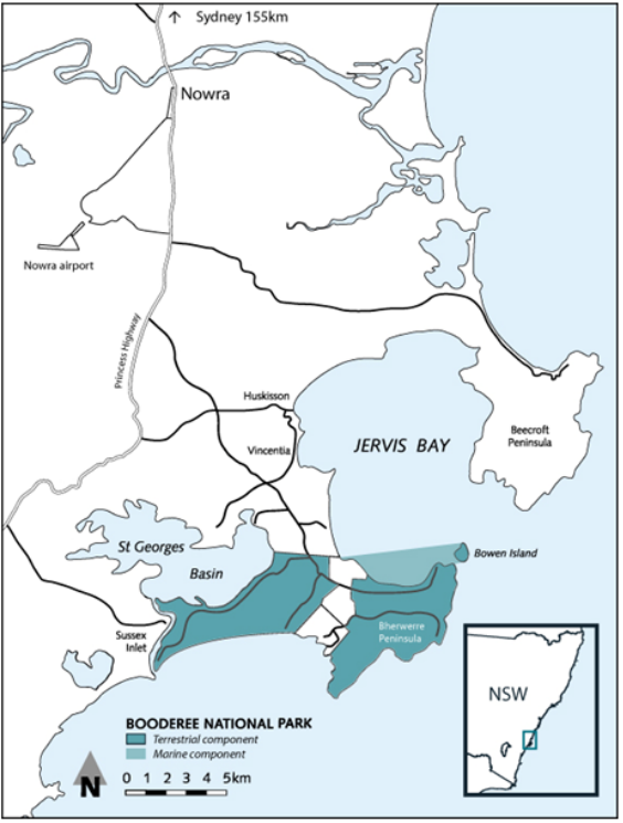
Booderee National Park is located on the south-east coast of Australia, within the Jervis Bay Territory. It comprises most of the Bherwerre Peninsula on the southern side of Jervis Bay and St Georges Basin and includes part of the waters of Jervis Bay (Map 1).
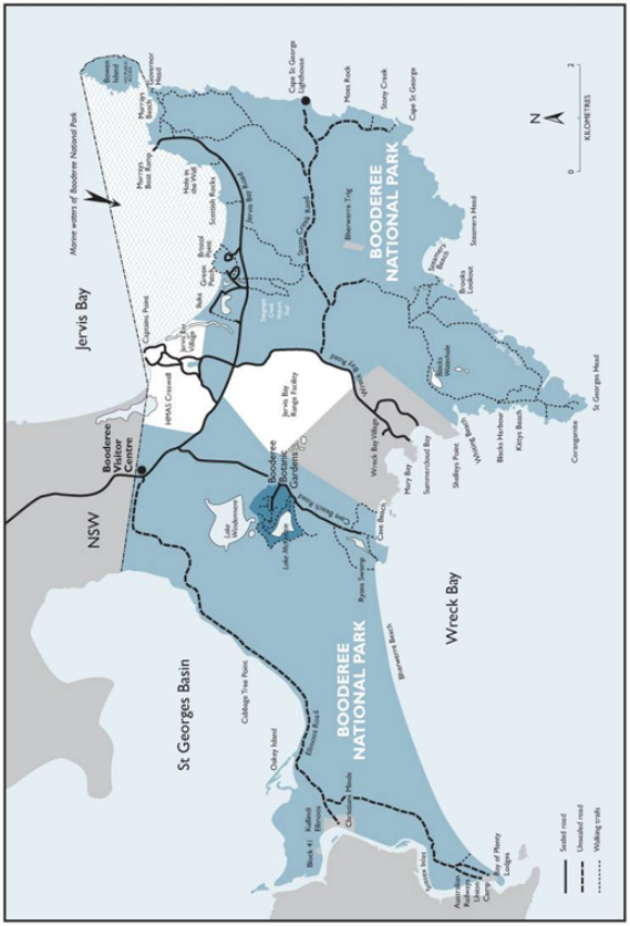
The park itself covers an area of 6,379 hectares which includes 875 hectares of marine environment (Map 2). The park is adjacent to 403 hectares of land owned by the Wreck Bay Aboriginal Community Council and to Commonwealth land used for residential and Defence purposes; the NSW Jervis Bay Marine Park and NSW Jervis Bay National Park also border much of the park.
Map 1: Location of Booderee National Park
Map 2: Booderee National Park
History
Koori people of Wreck Bay have always strongly pursued and been committed to the recognition of ownership of their traditional home in the Jervis Bay area. This commitment and pursuit of recognition have not wavered and have persevered through a number of changes to government administration and management of the area.
Aboriginal people lived in the Jervis Bay region long before the sea rose to its current level 6,000 years ago and the present Bherwerre Peninsula was created. Much evidence of coastal Aboriginal communities would have been submerged as sea levels rose; the oldest archaeological evidence of Aboriginal occupation in the region includes a site at Burrill Lake, about 30 kilometres south of Jervis Bay, dating to more than 20,000 years ago. More than 100 prehistoric Aboriginal sites have been recorded on the Bherwerre Peninsula, the majority shell middens but also rock shelters, burial sites, ceremonial grounds and stone-flaking sites. Axe-sharpening tools have also been found.
The land and waters now covered by Booderee National Park has been the subject of a range of uses since European settlement began in the region in the early 1800s. The first management plan for the park contained a summary of the area’s diverse European history which has included farming, forestry, tourism, Defence activities and the proposed development of a nuclear reactor, as well as nature conservation.
The Wreck Bay Aboriginal Community history and the processes leading to the establishment of Booderee National Park are outlined in Table 2. Following declaration of the Jervis Bay National Park by the Australian Government in 1992, title to the land and water covered by the park was conferred on the Wreck Bay Aboriginal Community Council in 1995, provided the area was leased back to the Director of National Parks to be managed as a national park.
In 1997, in line with provisions of the Lease, the Wreck Bay Aboriginal Community Council chose Booderee National Park as the new name for the park. 'Booderee' is an Aboriginal word from the Dhurga language meaning 'bay of plenty'.
Booderee’s significance is attributable to its rich natural and cultural heritage, the inclusion of both land and seascapes within a single protected area and its location.
How Booderee is significant locally
Booderee is home to the people of Wreck Bay. Koori people have always lived in the area and have strong cultural ties. These ties are evidenced today in oral cultural history, the knowledge and practice of the use of natural resources for food, for making of utensils and crafts, and in respect for country. Koori people of Wreck Bay are proud of their association with the area and have passed on the ancestral stories and creation stories throughout time. Parents recite such stories today to their children.
Many people from the local non-Aboriginal community also value Booderee as a place for recreation and a place where they can appreciate and learn about the park’s natural and cultural heritage. Some of the features used by local visitors include the best surf beaches in the region, excellent diving, snorkelling and kayaking opportunities, seasonal whale watching, regulated recreational fishing and great educational activities.
How Booderee is significant regionally
Booderee National Park lies in the southern portion of the Sydney Basin Bioregion. The park protects coastal dune systems and their associated habitats which are otherwise disturbed or potentially threatened in the bioregion. The area is scientifically valuable as it has not undergone the degradation that similar coastal sites (such as those surrounding Sydney) have suffered and Jervis Bay is registered as a type locality for many marine invertebrates and algal habitats.
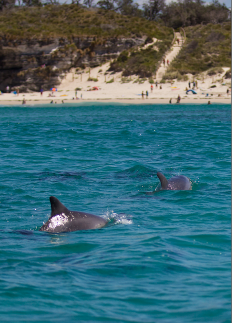
Jervis Bay supports a resident population of dolphins and the seasonal whale migration is an increasingly common feature as whale numbers recover. The preservation of a southern representative of the sandstone ecosystems of the Sydney Basin Bioregion is highly important as a contribution to the regional conservation of species and landscapes.
The area of the park has long been a popular destination for visitors. Christian’s Minde guest house on Sussex Inlet provided the first tourist accommodation in the area in 1896. Since then, the park has become a major tourist destination attracting over 450,000 visitors each year and making a significant contribution to the regional economy. Booderee also makes an important contribution to cooperative efforts to conserve the landscape of the Jervis Bay region. The conservation and enhancement of natural corridors in the wider region is important to the ongoing conservation of the park’s fauna and flora.
How Booderee is significant nationally
Jervis Bay is an important biogeographic area in Australia which contains a variety of relatively undisturbed marine and terrestrial habitats within a bioregion which is generally becoming highly urbanised. Booderee National Park protects a significantly large area of species-rich heath, a diversity of wetlands and saltmarshes. The park also protects one of the largest Posidonia seagrass meadows along the New South Wales coast, and unique algal communities of high conservation value. Lying between bioregions, the park’s marine diversity is exceptional. Jervis Bay is highly productive, driven by upwelling off the nearby continental shelf. This supports exceptionally large populations of baitfish and associated predators. The large breeding colony of little penguins (Eudyptula minor) on Bowen Island is one of the most significant in Australia, with exceptionally high breeding success and intact breeding habitat. The Jervis Bay area, particularly the area of the park, is an outstanding scenic location.
A number of plant and animal species which occur in Booderee have significant conservation status and warrant special protection because they are at the edge of their range, have limited distribution or are considered rare or threatened. The park is a major stronghold for the nationally endangered eastern bristlebird (Dasyornis brachypterus), and a substantial number of other fauna species are listed on New South Wales and Australian Government threatened species schedules or are subject to international treaties. Syzygium paniculatum and Cryptostylis hunteriana are the only known naturally occurring plant species in the park that are nationally threatened. The striking Grevillea macleayana is a naturally occurring endemic species, restricted to the Jervis Bay region. Four other plant species are considered rare nationally and the status of another is too poorly known to classify. Management prescriptions in this plan reflect the conservation requirements of these species.
The management arrangements in the park between the Wreck Bay Aboriginal Community Council and Parks Australia are increasingly being recognised for their significance as an effective example of joint management. The area is one of the few places in south-eastern Australia where recent and contemporary Koori lifestyles have continued in the setting of a substantially natural environment. The opportunities to educate visitors about the region’s Koori culture are among Booderee’s most important assets. The traditional owners have extensive experience in cultural interpretation and pride themselves on providing a quality and informative experience.
Geology
The underlying rock of the Bherwerre Peninsula is Permian sandstone of the southern Sydney Basin (about 260 million years old), while in a few small areas there is evidence of a Tertiary or older landscape (more than two million years old) which overlaid the Permian rocks. During the last ice age (20,000–15,000 years ago) the sea level was about 120 metres lower than it is now and the coastline was about 20 kilometres further east, near the edge of the continental shelf. Jervis Bay was then an open, vegetated valley more than 90 metres above sea level. The landscape as we know it, with its present coastline, dates from the stabilisation of the sea level about 6,000 years ago. Most of the surface of the Bherwerre Peninsula and Bowen Island is Quaternary sediments—sand dunes, swamp deposits and alluvium—younger than 10,000 years overlying the Permian sandstone.
Climate
Being coastal, temperature extremes are rare at Jervis Bay. Maximum temperatures range from an average of 24ºC in February to 16ºC in July, while average minimum temperatures range from 18ºC to 9.5ºC. Annual rainfall is approximately 1,200 millimetres which is relatively evenly distributed throughout the year although there is usually more rain in winter and less in spring. The prevailing winds in summer are north-easterly, while the main winter winds are from the south-west, but a clear daily cycle in wind patterns is superimposed on the seasonal changes.
Flora
The park contains a diverse range of well-preserved coastal plant communities including remnant rainforest, heath communities, woodland and coastal littoral communities; some 625 naturally occurring terrestrial plant species have been recorded. Jervis Bay also has some of the largest and most pristine seagrass meadows on the NSW coast. Seagrass meadows affect physical and chemical processes and play major roles in the biology of coastal ecosystems.
Fauna
Booderee is home to more than 30 native terrestrial and marine mammal species. There is also a diverse bird fauna with some 200 species recorded. In addition to some 35 terrestrial reptile species, four marine turtle species and one sea-snake species have been recorded. There are also 17 amphibian species. At least 308 fish and marine macroinvertebrate taxa were recorded during shallow water surveys in Jervis Bay. The bay’s macrobenthic fauna encompasses more than 500 species, including more than 150 polychaete species, 190 molluscs and 180 crustaceans.
Living collection
The living collection of the Booderee Botanic Gardens contains open ground plantings of some 1,200 taxa, which are cultivated and displayed to facilitate the study, conservation, promotion and enjoyment of Australia’s plant heritage, concentrating on species of the coastal regions of south-eastern Australia. Since the 1980s, the Botanic Gardens has been increasingly involved in ex-situ conservation of threatened species. More recent is the promotion of the Botanic Gardens as a centre for interpreting the cultural use of plants.
Heritage listings
In 2004 a number of sites in or including the park were listed as places in the Commonwealth Heritage List established under the EPBC Act:
- Cape St George Lighthouse Ruins and Curtilage for historical importance to maritime navigation history.
- Booderee Botanic Gardens for its importance to the traditional owners who have strong cultural and traditional ties to the area and as an important example of mid-twentieth century botanic gardens established to display native plants.
- The wider area of Jervis Bay Territory in recognition of its outstanding landscape features, its diversity of flora, fauna and archaeological sites and its value to past and present communities for recreational activities.
Appendix A lists the Commonwealth Heritage values of these places.
Two other sites in the Jervis Bay Territory adjacent to but outside the park are also included on the Commonwealth Heritage List—Christians Minde Settlement and the Royal Australian Naval College.
All the above sites, together with Bowen Island, the former Jervis Bay Nature Reserve and land owned by the Wreck Bay Aboriginal Community Council are listed on the Register of the National Estate. The register was frozen in February 2007 which means that no new places can be added or removed; it will continue to be a statutory register until February 2012 but has been replaced by other heritage lists under the EPBC Act.
The Wreck Bay people are the long-term custodians of the area. It is in our interest that the Wreck Bay people are involved in the management of the park. The Wreck Bay Aboriginal Community will ensure that important values, customs and beliefs will be maintained, promoted and enhanced at Booderee.
The Wreck Bay Aboriginal Community Council’s interests in Booderee are morally, ethically and legally reflected in the Council vision, the Lease, the Environment Protection and Biodiversity Conservation Act 1999 (EPBC Act) and the Aboriginal Land Grant (Jervis Bay Territory) Act 1986 (Land Grant Act).
The EPBC Act and Land Grant Act provide for traditional use of the land in the park for hunting, food gathering, ceremonial and religious purposes. The Environment Protection and Biodiversity Conservation Regulations 2000 (EPBC Regulations) permit the Director of National Parks to make areas of the park available for use by the traditional owners. Wreck Bay Aboriginal Community Council members are committed to promoting their traditional skills and knowledge in the workplace and to park visitors.
The Lease agreement (Appendix B) places obligations on the Director of National Parks to manage the park and to promote the interests of the traditional owners. The EPBC Act, Land Grant Act and the Lease set out the terms and conditions governing joint management, and the Lease provides for payment to the Council of annual rent and a proportion of income generated by the park. The Lease covers a period of 99 years and requires the Director to discuss possible variations with the Wreck Bay Aboriginal Community Council every five years.
The Director of National Parks is a Commonwealth statutory authority under the EPBC Act. The Director’s main functions are to administer, manage and control Commonwealth reserves, including Booderee. The Director is responsible for controlling activities in Commonwealth reserves, for example by issuing permits and making determinations under the EPBC Regulations.
The Booderee Board of Management (the Board), with a majority of representatives of the traditional owners, makes decisions relating to the management of the park and, in conjunction with the Director of National Parks, prepares the management plan. Other Board members are the Director of National Parks; a representative of the Australian Government department responsible for Jervis Bay Territory; a scientist familiar with the conservation values of the Jervis Bay region; the Commanding Officer of HMAS Creswell which is located in the Jervis Bay Territory; and a tourism representative familiar with the Jervis Bay region.
The Wreck Bay Aboriginal Community Council concerns are wider than park management and extend into community development, housing and other social issues. Although these are not directly the responsibility of the Director of National Parks, these issues and how the Council deals with them have an impact on the joint management arrangements and the success of joint management. The Council’s focus on park issues often relates to its aim of achieving outcomes that enhance the sound and economic development of the Wreck Bay Aboriginal Community.
The implementation of joint management at Booderee continues to evolve. The joint management structure is set out in the EPBC Act. The Act sets out the establishment of the Board and the basic philosophy of the working relationship between the Australian Government and the Wreck Bay Aboriginal Community Council. The success of the arrangements depends on a number of things, including implementation of this second management plan for Booderee which reflects the objectives and provisions of the Lease and the aspirations of the Wreck Bay people; further development of a shared decision-making relationship; and the increasing involvement of the Wreck Bay people in the management of the park.
The primary function of this management plan is to provide for the protection and conservation of the reserve. This plan clarifies management arrangements, provides for increased Community involvement in managing Booderee and sets out how Booderee will be managed for biodiversity conservation.
Sole management
The Wreck Bay Aboriginal Community is working towards sole management of Booderee National Park. The requirements of the Lease support progress towards this goal. The Director is providing training and employment opportunities for Community members, which are enhancing the Community’s opportunities to manage the park.
Maintaining Australian Government commitments
As part of the negotiations for joint management in 1995, the Australian Government made a number of funding and other commitments to the Community. Those commitments were made on the basis that the joint management arrangements for the park follow the model established for Uluru–Kata Tjuta National Park, namely grant of a 99-year lease in return for payment by the Australian Government of annual rent and a 25 per cent share of park income. That is the model under which Booderee has been jointly managed.
A particular commitment was to fund the design and construction of a cultural/visitors centre to be owned/operated by the Council, comparable to those at Uluru–Kata Tjuta and Kakadu National Parks and to be operable by the 2000 Olympics. At the time of preparing this plan, the design and construction of a new centre had not commenced. The Community is still endeavouring to ensure the Australian Government honours this commitment.
Contracts and employment
The Lease requires the Director, subject to the management plan, to:
- contract the Council’s services and engage as many Community members as is practicable to provide services in and in relation to the park
- encourage appropriate business and commercial initiatives and enterprises by the Council and Community members within the park.
At the time of preparing this plan, about half the park staff are Community members. In addition, Community members are employed in the park through contracts for management of the entry station, road maintenance, horticultural maintenance and cleaning.
The Community is keen to gain further contracts, which the Director supports. In line with the Lease, the Director will engage businesses owned by traditional owners and/or their associations to provide contract services in the park and work towards contracting out management of the visitor centre and the botanic gardens, consistent with relevant Australian Government purchasing procedures.
Budget
The Community is keen to increase revenue from and increase business opportunities in the park. Taking account of the requirements of the EPBC Act and the Lease, the Director, in conjunction with the Board, will consider and pursue new activities for the park that have potential to supplement the park’s annual budget. The Director will work collaboratively with the Community to develop strategies for sustainable business development and growing business which employs Community members.
Commercial opportunities
In 1999 the Community established Wreck Bay Enterprises Limited, a commercial company responsible for undertaking contracts awarded to the Council. The company operated for over ten years and provided services for the park including operation of the entry station, cleaning and road maintenance. The company was disbanded at the end of 2010 and its functions are now undertaken by the Council. The engagement of the Council for providing certain services to the park is seen as a means of developing new Community business opportunities and securing further contracts, both in and outside the park, creating more employment opportunities for Community members.
Training
The commitments made to the Community by the Australian Government as part of the negotiations regarding joint management included support for training Community members in park management and other forms of land management. In particular the Lease requires the Director to establish and implement a program for training reasonable numbers of the Community in skills relevant to the administration, management and control of the park. This is recognised as a critical part of progress towards the Community’s sole management vision. A training officer is employed in the park with a primary role of developing and implementing the training strategy for the park and Wreck Bay Aboriginal Community Council. The training officer is assisted by the Training Committee, made up of senior representatives of Parks Australia, and the Council. The Director will continue to initiate training opportunities for members of the Community through implementation of the Training Strategy.
Lease
The Lease provides for discussion between the Director and the Council about possible variations to the lease every five years. An existing management plan cannot be amended other than by a new plan. Therefore, if changes arising from review of the Lease require any change to the management plan, a new management plan incorporating the changes will be required.
Water
Fresh water for use in the Territory is extracted from the only natural exposed water table lake in the park, Lake Windermere. The lake has a restricted catchment, is shallow and subject to significant loss through evaporation, and is subject to changes in the water table. As such, lake levels vary greatly and reduced significantly prior to the preparation of this plan. Water conservation principles will continue to be applied to all water use in the park. As opportunities arise, facilities which use less water will replace existing facilities, particularly where water use is greatest. Water use efficiency will be considered when planning new buildings and horticultural infrastructure.
Table 2: Wreck Bay Aboriginal Community timeline and the establishment of Booderee National Park

Always…. Koori people have always used Bherwerre because of its rich diversity. It has always been a place of great significance to our people because of its unique location and its abundance of foods and medicines. It has provided us with an area where we can continue to pass on our traditional knowledge.
Early 1800s Europeans are given estates on the South Coast of New South Wales which starts the dispossession of land from the local Aboriginal people.
1830–1840 Local Aboriginal people are listed in the record for distribution of blankets and rations.
1880s Aboriginal reserves are established on the South Coast due to the dispossession of traditional lands.
1912 Royal Australian Naval College is established at Jervis Bay.
1915 Commonwealth acquires the Bherwerre Peninsula, which becomes a part of the Australian Capital Territory. Efforts are made at that stage to relocate the Aboriginal Community at Wreck Bay.
1924 First school is built at Wreck Bay.
1925 New South Wales Aboriginal Protection Board accepts the Australian Government offer to administer the Wreck Bay ‘reserve’ under the provision of the Aboriginal Protection Act 1909 (NSW). First manager is appointed.
1929–1949 Fish Protection Ordinance 1929–1949 has a provision that excludes Aboriginal residents of Jervis Bay Territory from paying fishing licence fees. Aboriginal initiative to establish a fishing industry in the region.
1940 Aboriginal Protection Act 1940 reflects shift from protectionism to assimilation policies in New South Wales. Aboriginal people are issued with ‘dog tags’. Cultural expression continues to be outlawed to fit in with the assimilation policy of the day.
1954 Wreck Bay Reserve is gazetted under the provisions of the Aborigines Welfare Ordinance 1954 (ACT). Provisions of the Aborigines Protection Act 1940 (NSW) no longer apply.
1965 Aborigines Welfare Ordinance 1954 (ACT) is repealed, thus effecting the transfer of the ‘reserve’ from the Aborigines Welfare Board to the Commonwealth Department of Interior. At the same time, the reserve is abolished and declared an ‘open village’. Assimilation policy of the day brings about attempts to house non-Aboriginals at Wreck Bay, which the Community opposes. Efforts are again made to relocate the Community once again. Wreck Bay School is moved to Jervis Bay.
 1965–1966 Wreck Bay Progress Association is formed to counter the open village status and to secure land tenure, thus securing the Community’s future.
1971 Proclamation under the Public Parks Ordinance 1928 (ACT) of the Jervis Bay Nature Reserve over the majority of the Jervis Bay Territory includes the non-residential land of the reserve.
1973–1974 The Wreck Bay Housing Company and the Wreck Bay Women's Committee are formed. Land rights issues are the main subject for discussion between the Community and the Commonwealth Government.
1979 Blockade of the Summercloud Bay Road prevents the general public’s access to the Summercloud Bay day visitor area. This action is taken as a result of the land ownership issue.
1985 Announcement by the Prime Minister of plans to transfer the Fleet Base and Armaments Depot to Jervis Bay. The Wreck Bay people oppose this decision because of the impact on the cultural and natural environment of the region. The land rights movement accelerates.
1986 The Aboriginal Land Grant (Jervis Bay Territory) Act 1986 is enacted. The Wreck Bay Aboriginal Community secures tenure of 403 hectares of land via the Land Grant Act and the Wreck Bay Aboriginal Community Council is established.
1992 The Jervis Bay Nature Reserve, additional Commonwealth lands and the waters of the Jervis Bay Territory are proclaimed as the Jervis Bay National Park under the National Parks and Wildlife Conservation Act 1975 (Parks Act). The Wreck Bay Aboriginal Community is offered two positions on a Board of Management of the newly declared park. The offer is rejected.
1993 Commonwealth Government announces that the Armaments Depot will be built in Victoria. The Native Title Act 1993 is enacted.
1994 The Commonwealth Government Ministers for Aboriginal and Torres Strait Islander Affairs and the Environment announce their intention to make a land grant of the Jervis Bay National Park to the Wreck Bay Aboriginal Community. Amendments to the Land Grant Act and the Parks Act are introduced to facilitate the land grant.
1995 Amendments pass both houses of Parliament and the Wreck Bay Aboriginal Community Council is granted freehold title to Jervis Bay National Park and the Jervis Bay annex of the Australian National Botanic Gardens. Park and gardens are leased back to the Director of National Parks.

1996 The Jervis Bay National Park Board of Management is established with a majority of Wreck Bay Aboriginal Community representatives. For the first time the Wreck Bay people have a real say on how traditional lands are managed.
1997 The Wreck Bay Aboriginal Community Council lodges a land claim for the remaining areas in the Jervis Bay Territory, which are not Aboriginal land.
1997 To reflect Aboriginal ownership the name Jervis Bay National Park is changed to Booderee National Park.
1999 Wreck Bay Enterprises Limited is established.
2000 Interdepartmental Committee is established to look at a number of issues in Jervis Bay Territory including the Wreck Bay land claim.
2000 Booderee Botanic Gardens are legally incorporated into Booderee National Park in May 2000.
2000 Parks Act is replaced by the Environment Protection and Biodiversity Conservation Act 1999 in July 2000.
2002 First plan of management is produced for Booderee National Park.
2003 Wreck Bay enters into a Service Agreement with the Director of National Parks, marking the first step towards the sole management vision.
2008 Implementation of the first management plan is completed and reported to the Board of Management through an audit.
2008 Draft Cultural Heritage Strategy is completed for the Wreck Bay Aboriginal Community Council and a working group established by the Community to identify cultural heritage priorities for the next ten years.
2009 Second phase of outsourcing commences. Discussion begins about developing an Aboriginal business enterprise in the park focusing on cultural heritage.
2009 Formation of a Junior Ranger program as a joint Wreck Bay/Booderee National Park initiative.
Management Plan for
Booderee National Park


Part 1 – Introduction
This part of the plan sets out the context in which this second management plan for Booderee National Park was prepared. It describes the previous plan and the network of legislative requirements, international agreements and the Lease which underpin the content of the plan.
This is the second management plan for Booderee National Park. The first plan came into operation in 2002 and ceased to have effect on 3 April 2009. Section 357 of the Environment Protection and Biodiversity Conservation Act 1999 (EPBC Act) allows the Director to manage a Commonwealth reserve following the expiration of a management plan in accordance with the IUCN management principles for the IUCN category to which the reserve was assigned under an expired management plan.
In August 2008, the Booderee National Park Board of Management resolved to use the first management plan as a guide for developing the second plan.
Section 366 of the EPBC Act requires that the Director of National Parks and the Board of Management (if any) for a Commonwealth reserve prepare management plans for the reserve. In addition to seeking comments from members of the public, the relevant land council and the relevant state or territory government, the Director and the board are required to take into account the interests of the traditional owners of land in the reserve and of any other Indigenous persons interested in the reserve.
Other stakeholders consulted during the preparation of this management plan included Australian Government agencies (Defence, Department of Infrastructure and Regional Development); NSW agencies (National Parks and Wildlife Service, Marine Parks Authority, Fisheries); Shoalhaven City Council; and regional tourism bodies.
The outcomes in the plan are developed against the following key result areas reflected in the Strategic Planning and Performance Assessment Framework:
- Natural heritage management (see Section 6 of the plan)
- Cultural heritage management (see Section 6)
- Joint management and working with Indigenous communities
(see Section 4 and 5) - Use and appreciation of protected areas (see Section 7)
- Stakeholders and partnerships (see Section 8)
- Business management (see Section 9)
Management plans for reserves managed by Parks Australia operate in the context of both wider strategic plans and work plans for individuals involved in delivering management plan prescriptions. During the life of the first management plan, Booderee National Park developed a planning and implementation system which included works programs based on plan prescriptions and recording of effort against those prescriptions. The planning component of the system allowed for the preparation of annual implementation plans that prioritised prescriptions and assigned projects to individual staff and work teams. These work plans were in turn attached to individuals’ performance development plans.
Towards the end of the first plan, a technical audit of the plan’s implementation was made using this planning and implementation system. Actions taken against each prescription in the plan were audited to see how those actions had contributed to achieving the plan’s specified aims. This was done through data analysis or expert opinion. Status and trend (stable, positive or negative) were assessed for each of the values specified in management plan aims, to assist with understanding the current state of these values and with prioritising future management activities.
The Booderee National Park Board of Management has endorsed this approach and has resolved that annual reports on the status and trend of key issues would assist them to redirect management efforts over the life of the plan. This is an important adaptive management process.
Sections 3 to 9 of this plan begin with a summary of performance under the first plan, as a baseline for defining future management activities. Measures are also identified for assessing performance under this second plan against the key result areas and reporting to the Board.
This management plan should be cited as the Booderee National Park Management Plan or the Booderee Management Plan.
This management plan will come into operation following approval by the Minister under s.370 of the EPBC Act, on a date specified by the Minister or the date it is registered under the Legislative Instruments Act 2003, and will cease to have effect ten years after commencement, unless revoked sooner or replaced with a new plan.
In this management plan:
Aboriginal means a person who is a member of the Aboriginal race of Australia
Aboriginal tradition means the body of traditions, observances, customs and beliefs of Aboriginals generally or of a particular group of Aboriginals and includes those traditions, observances, customs and beliefs as applied in relation to particular persons, sites, areas of Booderee National Park, things and relationships
Australian Government means the Government of the Commonwealth of Australia
Board of Management (or Park Board or Board) means the Booderee National Park Board of Management established under the National Parks and Wildlife Conservation Act 1975 (Parks Act) and continued under the EPBC Act by the Environmental Reform (Consequential Provisions) Act 1999
Booderee Botanic Gardens (or Botanic Gardens) means that part of Booderee National Park formerly part of the Australian National Botanic Gardens and included in Booderee National Park by proclamation on 25 May 2000
Booderee National Park (or Booderee or Park) means the area declared as Jervis Bay National Park under the Parks Act, later renamed as Booderee National Park under the Parks Act and continued as a Commonwealth reserve under the EPBC Act by the Environmental Reform (Consequential Provisions) Act 1999
Commonwealth reserve means a reserve declared under Division 4 of Part 15 of the EPBC Act
Community means the community known as the Wreck Bay Aboriginal Community
Council means the Wreck Bay Aboriginal Community Council established and constituted by the Land Grant Act
Defence means the Department of Defence and includes all agencies that comprise the Australian Defence Organisation
Director means the Director of National Parks under s.514A of the EPBC Act and includes Parks Australia and any person to whom the Director has delegated powers and functions under the EPBC Act in relation to Booderee National Park, and including any agency that succeeds to the functions of the Director
EPBC Act means the Environment Protection and Biodiversity Conservation Act 1999 and includes reference to any Act amending, repealing or replacing the EPBC Act
EPBC Regulations means the Environment Protection and Biodiversity Conservation Regulations 2000 and includes reference to any Regulations amending, repealing or replacing the EPBC Regulations
Jervis Bay Territory Administration (or Administration) means that part of the Australian Government agency with responsibility for administration of the Jervis Bay Territory. At the time of preparing the plan, that agency was the Australian Government Department of Infrastructure and Regional Development.
Koori means Aboriginal people of south-eastern Australia
Land Grant Act means the Aboriginal Land Grant (Jervis Bay Territory) Act 1986
Lease means the Memorandum of Lease between the Council and the Director, unless otherwise stated
Mining operations means mining operations as defined by the EPBC Act
Minister means the Minister administering the EPBC Act
Parks Act means the National Parks and Wildlife Conservation Act 1975 and the Regulations under that Act
Parks Australia means the Director of National Parks and the agency that assists the Director in performing the Director’s functions under the EPBC Act. At the time of preparing the plan, the agency assisting the Director is the Parks Australia Division of the Australian Government Department of the Environment
Personal watercraft means a power-driven vessel that:
(a) has a fully enclosed hull; and
(b) does not retain water taken on if it capsizes; and
(c) is designed to be operated by a person standing, sitting astride or kneeling on the vessel but not seated within the vessel and includes a jet ski
Reserve management principles means the Australian IUCN reserve management principles set out in Schedule 8 of the EPBC Regulations (see Appendix C)
Ride means to ride a non-motorised vehicle such as a pedal-powered bicycle.
Territory means the Jervis Bay Territory
Track for walking or riding means a track for walking or riding that has been provided by the Director in accordance with EPBC subregulation 12.55(2).
Traditional Aboriginal owners (or traditional owners) means those members of the Wreck Bay Aboriginal Community Council whose names are recorded on the Council Register as being members of the Council
Traditional use and traditional activity mean a use or activity undertaken in accordance with Aboriginal tradition
Vehicle access road means a road in a Commonwealth reserve that:
(a) is a sealed road; and
(b) does not have a sign displayed on or near it indicating that it is prohibited to use motor vehicles on the road at that time.
Vehicle access track means a road in a Commonwealth reserve that:
(a) is an unsealed road; and
(b) has a sign, erected by the Director, with the words ‘Vehicle Access Track’ displayed at the point or points that motor vehicles would normally access the track; and
(c) there are no signs displayed on the track indicating that it is prohibited to use motor vehicles on the track at that time.
Acronyms
ACT Australian Capital Territory
IUCN International Union for Conservation of Nature
JBT Jervis Bay Territory
NSW New South Wales
Scuba Self-contained underwater breathing apparatus
The Lease
All of the land in the park, including the seabed of Jervis Bay within the park, is Aboriginal land under the Land Grant Act with title held by Wreck Bay Aboriginal Community Council. The Council has leased the land to the Director in accordance with the Land Grant Act for the purposes of being managed as a Commonwealth reserve.
EPBC Act
Objects of the Act
The objects of the EPBC Act as set out in Part 1 of the Act are:
(a) to provide for the protection of the environment, especially those aspects of the environment that are matters of national environmental significance; and
(b) to promote ecologically sustainable development through the conservation and ecologically sustainable use of natural resources; and
(c) to promote the conservation of biodiversity; and
(ca) to provide for the protection and conservation of heritage; and
(d) to promote a co-operative approach to the protection and management of the environment involving governments, the community, land-holders and Indigenous peoples; and
(e) to assist in the co-operative implementation of Australia’s international environmental responsibilities; and
(f) to recognise the role of Indigenous people in the conservation and ecologically sustainable use of Australia’s biodiversity; and
(g) to promote the use of Indigenous people’s knowledge of biodiversity with the involvement of, and in cooperation with, the owners of the knowledge.
Establishment of the park
The park and the then separate Botanic Gardens were proclaimed under the Parks Act as the Jervis Bay National Park and as the Jervis Bay component of the Australian National Botanic Gardens in 1992 and 1991 respectively. In May 2000 the Botanic Gardens were removed from the Australian National Botanic Gardens and added to Booderee National Park by proclamation. The Parks Act was replaced by the EPBC Act in July 2000. The park continues as a Commonwealth reserve under the EPBC Act pursuant to the Environmental Reform (Consequential Provisions) Act 1999, which deems the park to have been declared for the following purposes:
- the preservation of the area in its natural condition
- the encouragement and regulation of the appropriate use, appreciation and enjoyment of the area by the public.
In 1998, in accordance with provisions of the Lease, the name of the park was amended by proclamation under the Parks Act to Booderee National Park.
Director of National Parks
The Director of National Parks is a corporation under the s.514A of the EPBC Act. The corporation is controlled by the person appointed by the Governor-General to the office that is also called the Director of National Parks (s.514F).
The functions of the Director (s.514B) include the administration, management and control of the park. The Director generally has power to do all things necessary or convenient for performing the Director’s functions (s.514C). The Director has a number of specified powers under the EPBC Act and EPBC Regulations, including to prohibit or control some activities, and to issue permits for activities that are otherwise prohibited. The Director performs functions and exercises powers in accordance with this plan and decisions of the Board of Management, consistent with the plan.
Booderee National Park Board of Management
The Booderee National Park Board of Management was established (as the Jervis Bay National Park Board of Management) under the Parks Act and continues under the EPBC Act. A majority of Board members must be Indigenous persons nominated by the traditional owners of land in the park. The functions of the Board under s.376 of the EPBC Act are:
- to make decisions relating to the management of the park that are consistent with the management plan in operation for the park; and
- in conjunction with the Director, to:
- prepare management plans for the park; and
- monitor the management of the park; and
- advise the Minister on all aspects of the future development of the park.
Board sub-committees
At the time of preparing the plan, there were two Board sub-committees to assist the Board in making decisions:
- Steering Committee for Interpretation, Education and Information – established to provide advice and guidance to the Board on strategic planning, specific projects and policy matters relating to education, interpretation and information.
- Booderee National Park Training Committee - established to provide advice and guidance to the Board on training priorities and to implement the Training Strategy.
These committees are created and operate under terms of reference determined by the Board.
Management plans
The EPBC Act requires the Board, in conjunction with the Director, to prepare management plans for the park. When prepared, a plan is given to the Minister for approval. A management plan is a ‘legislative instrument’ for the purposes of the Legislative Instruments Act 2003 and must be registered under that Act. Following registration, the plan is tabled in each House of the Commonwealth Parliament and may be disallowed by either House on a motion moved within 15 sitting days of the House after tabling.
A management plan for a Commonwealth reserve has effect for ten years, subject to being revoked or amended earlier by another management plan for the reserve.
See Section 2.5 in relation to EPBC Act requirements for a management plan.
A management plan does not go into detail to describe each activity undertaken in the park. A range of strategies, plans and policies are developed from time to time to articulate management programs and responses. A list of the majority of such documents being used and/or developed at the time of preparing this plan appears as Appendix D to this plan.
Control of actions in Commonwealth reserves
The EPBC Act (ss.354 and 354A) prohibits certain actions being taken in Commonwealth reserves except in accordance with a management plan. These actions are:
- kill, injure, take, trade, keep or move a member of a native species; or
- damage heritage; or
- carry on an excavation; or
- erect a building or other structure; or
- carry out works; or
- take an action for commercial purposes.
These prohibitions, and other provisions of the EPBC Act and Regulations dealing with activities in Commonwealth reserves, do not prevent Aboriginal people from continuing their traditional use of Booderee National Park for hunting or gathering (except for the purposes of sale) or for ceremonial and religious purposes (s.359A).
The EPBC Act also does not affect the operation of s.211 of the Native Title Act 1993 which provides that holders of native title rights covering certain activities do not need authorisation required by other laws to engage in those activities (s.8 EPBC Act).
Mining operations are prohibited in Booderee National Park by the EPBC Act (ss.355 and 355A) except where authorised under a management plan.
The EPBC Regulations control, or allow the Director to control, a range of activities in Commonwealth reserves such as camping, use of vehicles and vessels, littering, commercial activities, commercial fishing, recreational fishing and research. The Director applies the Regulations subject to and in accordance with the EPBC Act and management plans. The Regulations do not apply to the Director or to wardens or rangers appointed under the EPBC Act. Activities that are prohibited or restricted by the EPBC Act may be carried on if they are authorised by a permit issued by the Director and/or they are carried on in accordance with a management plan or if another exception prescribed by r.12.06(1) of the Regulations applies.
Access to biological resources in Commonwealth areas is regulated under Part 8A of the EPBC Regulations. Access to biological resources is also covered by ss.354 and 354A of the EPBC Act if the resources are members of a native species and/or if access is for commercial purposes.
Environmental impact assessment
Actions that are likely to have a significant impact on ‘matters of national environmental significance’ are subject to the referral, assessment and approval provisions of Chapters 2 to 4 of the EPBC Act (irrespective of where the action is taken).
At the time of preparing this plan, the matters of national environmental significance identified in the EPBC Act are:
- World Heritage listed properties
- National Heritage listed places
- Ramsar wetlands of international importance
- nationally listed threatened species and ecological communities
- listed migratory species
- nuclear actions (including uranium mining).
- Commonwealth marine areas
- Great Barrier Reef Marine Park
The referral, assessment and approval provisions also apply to actions on Commonwealth land that are likely to have a significant impact on the environment and to actions taken outside Commonwealth land that are likely to have a significant impact on the environment on Commonwealth land. The park is Commonwealth land for the purposes of the EPBC Act.
Responsibility for compliance with the assessment and approvals provisions of the EPBC Act lies with persons taking relevant ‘controlled’ actions. A person proposing to take an action that the person thinks may be or is a controlled action should refer the proposal to the Minister for the Minister’s decision whether or not the action is a controlled action. The Director of National Parks may also refer proposed actions to the Minister.
Wildlife protection
The EPBC Act also contains provisions (Part 13) that prohibit and regulate actions in relation to listed threatened species and ecological communities, listed migratory species, cetaceans and listed marine species. Appendix E to this plan lists species of significance to the park, including species that are listed under the EPBC Act and NSW legislation and under international conventions, treaties and agreements at the time of preparing this plan.
Actions taken in a Commonwealth reserve in accordance with a management plan in relation to members of species listed under Part 13 of the Act are exempt from prohibitions that would otherwise apply under Part 13.
Heritage protection
The Jervis Bay Territory (which includes the area occupied by the park) is listed as a place in the Commonwealth Heritage List under the EPBC Act. The Booderee Botanic Gardens and Cape St George Lighthouse Ruins and Curtilage located within the park are also listed as places in the Commonwealth Heritage List.
At the time of preparing this plan the Hive Shipwreck Survivors’ Camp was under consideration for inclusion in the Commonwealth Heritage List. The site will be managed in accordance with Commonwealth Heritage management principles if listed during the life of this plan.
The EPBC Act heritage protection provisions (ss.324A to 324ZC and ss.341A to 341ZH) relevantly provide:
- for establishment and maintenance of a National Heritage List and a Commonwealth Heritage List, criteria and values for inclusion of places in either list and heritage management principles for places that are included in the two lists
- that Commonwealth agencies must not take an action that is likely to have an adverse impact on the heritage values of a place included in either list unless there is no feasible and prudent alternative to taking the action and all measures that can reasonably be taken to mitigate the impact of the action on those values are taken
- that Commonwealth agencies that own or control places must:
- prepare a written heritage strategy for managing those places to protect and conserve their Commonwealth Heritage values. The strategy must address any matters required by the EPBC Regulations, and not be inconsistent with the Commonwealth Heritage management principles
- identify Commonwealth Heritage values for each place, and produce a register that sets out the Commonwealth Heritage values (if any) for each place (and do so within the timeframe set out in the place’s heritage strategy).
The prescriptions within this management plan are consistent with Commonwealth Heritage and National Heritage management principles and other relevant obligations under the EPBC Act for protecting and conserving the heritage values for which the park has been listed on the Commonwealth Heritage List and nominated on the National Heritage List.
Appendices C and D identify Commonwealth Heritage values and compliance with Commonwealth Heritage management principles relevant to the park.
Penalties
Civil and criminal penalties may be imposed for breaches of the EPBC Act.
The purpose of this management plan is to describe the direction of management for the park for the next ten years in accordance with the EPBC Act. It identifies desired outcomes and actions required to achieve these outcomes. The plan enables management to proceed in an orderly way, helps reconcile competing interests and identifies priorities for the allocation of available resources.
In line with the aspirations of the Wreck Bay Aboriginal Community Council for sole management of the park, this plan aims to develop and enhance the Community’s ability to eventually manage the park.
Under s.367(1) of the EPBC Act, a management plan for a Commonwealth reserve (in this case, the park) must provide for the protection and conservation of the reserve. In particular, a management plan must:
(a) assign the reserve to an IUCN category (whether or not a Proclamation has assigned the reserve or a zone of the reserve to that IUCN category); and
(b) state how the reserve, or each zone of the reserve, is to be managed; and
(c) state how the natural features of the reserve, or of each zone of the reserve, are to be protected and conserved; and
(d) if the Director holds land or seabed included in the reserve under lease—be consistent with the Director’s obligations under the lease; and
(e) specify any limitation or prohibition on the exercise of a power, or performance of a function, under the EPBC Act in or in relation to the reserve; and
(f) specify any mining operation, major excavation or other work that may be carried on in the reserve, and the conditions under which it may be carried on; and
(g) specify any other operation or activity that may be carried on in the reserve; and
(h) indicate generally the activities that are to be prohibited or regulated in the reserve, and the means of prohibiting or regulating them; and
(i) indicate how the plan takes account of Australia’s obligations under each agreement with one or more other countries that is relevant to the reserve (including the World Heritage Convention and the Ramsar Convention, if appropriate); and
(j) if the reserve includes a National Heritage place:
(i) not be inconsistent with the National Heritage management principles; and
(ii) address the matters prescribed by regulations made for the purposes of paragraph 324S(4)(a); and
(k) if the reserve includes a Commonwealth Heritage place:
(i) not be inconsistent with the Commonwealth Heritage management principles; and
(ii) address the matters prescribed by regulations made for the purposes of paragraph 341S(4)(a).
In preparing a management plan the EPBC Act (s.368) also requires account to be taken of various matters. In respect to Booderee National Park these matters include:
- the regulation of the use of the park for the purpose for which it was declared
- the interests of:
- the traditional owners of the park
- any other Indigenous persons interested in the park
- any person who has a usage right relating to land, sea or seabed in the park that existed (or is derived from a usage right that existed) immediately before the park was declared
- the protection of the special features of the park, including objects and sites of biological, historical, palaeontological, archaeological, geological and geographical interest
- the protection, conservation and management of biodiversity and heritage within the park
- the protection of the park against damage
- Australia's obligations under agreements between Australia and one or more other countries relevant to the protection and conservation of biodiversity and heritage.
In addition to assigning a Commonwealth reserve to an IUCN protected area category, a management plan may divide a Commonwealth reserve into zones and assign each zone to an IUCN category. The category to which a zone is assigned may differ from the category to which the reserve as a whole is assigned (s.367(2)).
The provisions of a management plan must not be inconsistent with the reserve management principles for the IUCN category to which the reserve or zone of the reserve is assigned (s.367(3)). See Section 3.1 for information on Booderee’s IUCN categories.
The park was granted to the Wreck Bay Aboriginal Community Council on behalf of the Wreck Bay Aboriginal Community in 1995 and leased to the Director of National Parks as a Commonwealth reserve. The Lease expires on 10 October 2094. With the exception of the term, the provisions of the Lease may be reviewed by the Council and the Director every five years, or at any agreed time. Five years before the Lease expires, the Council and the Director will enter into negotiations for its renewal or extension, unless the Lease has been terminated. The Council and the Director may agree in writing to terminate the Lease at any time.
Where the enactment, repeal or amendment of an Act or Regulation:
- is inconsistent with the Lease, the management plan, the Council’s rights as lessor or the Council’s ownership of the fee simple in the park; and
- is materially prejudicial to the rights of the Council or the Community regarding the ownership, occupation, use, administration, management or control of the park,
the Lease is deemed to be breached.
Such action may lead to termination of the Lease on 18 months notice by the Council. Where a termination notice is issued, the Council and the Director must meet as soon as possible and enter into bona fide negotiations with a view to a new lease being granted.
Under the Lease the following rights of the Community are reserved, subject to prior approval of the Council, the directions or decisions of the Board relating to health, safety, privacy or protection of the park and any such reasonable constraints mentioned within the management plan:
- the right to enter, use and occupy the park in accordance with the Aboriginal tradition of the Community
- the right to continue to use the park for traditional hunting and food gathering in accordance with law and for ceremonial and religious purposes
- the right to reside in the park at other locations as may be specified in the management plan.
The Director’s responsibilities under the Lease include:
- at the request of the Council, subletting any reasonable part of the park to a Community member provided it is in accordance with the EPBC Act and the plan
- paying rent to the Council
- promoting and protecting the interests of the Community and sacred sites, areas and things of significance to the Community
- promoting and assisting in the provision of resources for the involvement of Community members in the development of management plans and in the operations and management of the park
- promoting the employment and training of Community members
- contracting the Council’s services and engage as many Community members as practicable to provide services in the park
- promoting understanding of and respect for Aboriginal traditions, languages, cultures, customs and skills
- encouraging business and commercial enterprises by the Council in the park
- providing funding to the Council to fulfil Community liaison functions
- providing resources for the adequate maintenance of roads and other facilities
- implementing a licensing scheme for tour operators and other commercial operators
- properly collecting and auditing entrance fees and other charges
- assisting with a business case and seeking funding for construction of a Cultural Centre
- subject to the plan and taking into account the Director’s financial duties under legislation and relevant policies, contracting out appropriate services in the park and giving preference to the Council to provide those services.
The full provisions of the Lease at the time of preparing this plan are at Appendix B.
This plan must take account of Australia’s obligations under relevant international agreements. The following agreements are relevant to the park and are taken into account in this plan. Species listed under the agreements and conventions are listed species under Part 13 of the EPBC Act. Appendix E to this management plan includes listed migratory and marine species found in the park.
Agreement on the Conservation of Albatrosses and Petrels (ACAP)
ACAP is a multilateral agreement which seeks to conserve albatrosses and petrels by coordinating international activity to mitigate known threats to albatross and petrel populations. Four species listed under this agreement are found in Booderee.
Convention on the Conservation of Migratory Species of Wild Animals
(Bonn Convention)
The Bonn Convention aims to conserve terrestrial, marine and avian migratory species throughout their range. Parties to this convention work together to conserve migratory species and their habitats. Twenty-seven species listed under this convention are found in Booderee.
China–Australia Migratory Bird Agreement (CAMBA)
CAMBA provides for China and Australia to cooperate in the protection of migratory birds listed in the annex to the agreement and their environment, and requires each country to take appropriate measures to preserve and enhance the environment of migratory birds. Twenty species listed under this agreement occur in Booderee.
Japan–Australia Migratory Bird Agreement (JAMBA)
JAMBA provides for Japan and Australia to cooperate in taking measures for the management and protection of migratory birds, birds in danger of extinction, and the management and protection of their environments, and requires each country to take appropriate measures to preserve and enhance the environment of birds protected under the provisions of the agreement. Twenty-three species listed under this agreement are found in Booderee.
The Nagoya Protocol
In October 2010 the Conference of Parties to the Convention on Biological Diversity adopted the ‘Nagoya Protocol on Access to Genetic Resources and the Fair and Equitable Sharing of Benefits Arising from their Utilization’, also known as the Nagoya Protocol. Australia signed the protocol in January 2012, and is committed to its full implementation and ratification. The protocol establishes a legally-binding framework for access to genetic resources for research activities, sharing the benefits from their use or the use of associated Traditional Knowledge. Access to biological resources in Commonwealth areas such as the park is regulated under the EPBC Act and EPBC Regulations (see also Section 6.12, Research and monitoring).
Republic of Korea–Australia Migratory Bird Agreement (ROKAMBA)
ROKAMBA provides for the Republic of Korea and Australia to cooperate in taking measures for the management and protection of migratory birds and their habitat by providing a forum for the exchange of information, support for training activities and collaboration on migratory bird research and monitoring activities. Fifteen species listed under this agreement are found in Booderee.
United Nations Declaration on the Rights of Indigenous Peoples
The Director and the Board of Management acknowledges the Australian Government’s support for the United Nations Declaration on the Rights of Indigenous Peoples. As an international instrument, the declaration provides a blueprint for Indigenous people and governments around the world, based on the principles of self-determination and participation and respect for the rights and roles of Indigenous people within society. The declaration contains the minimum standards for the survival, dignity and well-being of Indigenous peoples all over the world. Joint management of the park supports many of the principles of the declaration.


PART 2 – HOW THE PARK WILL BE MANAGED

Performance indicator
- Degree of management compliance with the relevant Australian IUCN reserve management principles.
Performance under first plan
The technical audit of the first plan identified a negative trend in relation to zoning and IUCN categorisation. Zoning in accordance with the requirements of the first plan was established but education about and enforcement of marine zones proved difficult. There were repeated serious breaches of recreational fishing limits which may have compromised park values.
Aim
- Booderee is managed in accordance with IUCN categories II (National Park) and IV (Habitat protection zone), providing for appropriate use of the park while protecting its natural and cultural features (See Section 3.1.3).
Background
The categorisation and zoning scheme takes into account the requirements of the EPBC Act and Regulations including relevant reserve management principles; regional conservation strategies aimed at conserving biodiversity through such things as the maintenance of habitat corridors and water quality; protection of endangered species and habitat; and conservation of the marine environment.
As noted in Section 2.6, IUCN Category, the EPBC Act requires a Commonwealth reserve to be assigned to an IUCN category. The EPBC Act also allows a management plan to divide a reserve into zones and to assign the zones to an IUCN category, which may differ from the overall category of the reserve. The EPBC Regulations prescribe the reserve management principles for each IUCN category.
The technical audit of the first plan identified the need to improve marine zoning strategies following repeated serious breaches of recreational fishing limits and concerns about impacts on marine species. There were insufficient research results and data available to determine the most appropriate strategies to protect the park’s marine waters. A priority of this plan will be to implement an enforceable and effective response to protecting the values of the park’s marine component.
Issues
- An appropriate level of protection needs to be assigned to each zone identified within the park
- Additional research is required to determine and provide for sustainable and appropriate use of the marine component of the National Park.
- There is a need for capacity to review and amend the level of protection assigned to the marine component of the park if further research and monitoring indicates additional protection is required.
Prescriptions
Policies
3.1.1 The park is assigned to IUCN category II (national park) and will be managed in accordance with the reserve management principles set out in Schedule 8 of the EPBC Regulations and listed in Appendix C.
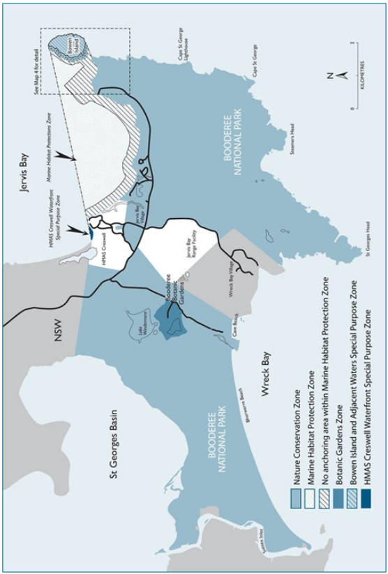
3.1.2 The park is divided into five management zones to assist with the protection of natural heritage within the park (refer to Table 3 and Maps 3 and 4 for description and location of the zones). The zones and their associated management purposes are:
- Nature Conservation Zone
- Protection and appreciation of terrestrial and marine natural and cultural heritage
- Protection of Lake Windermere water quality
- Providing for no-take recreational activities in a natural setting
2. Marine Habitat Protection Zone
- Providing a high level of protection for marine and intertidal areas of the park
- Protecting sensitive marine habitats such as seagrass beds
- Providing for appropriate recreational and commercial activities that are consistent with the protection of natural values
3. Botanic Gardens Zone
- Management, presentation, appreciation and study of a representative living collection of plants of south-eastern Australia with a particular emphasis on Indigenous plant use
- Providing for sustainable recreation in a modified setting
- Providing for environmentally sustainable commercial development, particularly in the form of Indigenous business enterprises
4. Bowen Island and Adjacent Waters Special Purpose Zone
- Providing high levels of protection for seabird, fish and marine invertebrate habitat and breeding areas
- Protection of cultural sites including middens
5. HMAS Creswell Waterfront Special Purpose Zone
- Protection of natural values
- Exclusion of public access to waters adjacent to Defence infrastructure and facilities for safety and security reasons
3.1.3 Zones 1, 2, 4 and 5 are assigned to IUCN category II (national park). Zone 3 is assigned to category IV (habitat/species management area).
3.1.4 Activities undertaken within each zone must be appropriate to the management purposes of each zone (see Table 4 for examples of types of activities appropriate to each zone).
3.1.5 The zoning scheme does not prevent the Director closing areas or restricting activities in the park in the future as provided under the EPBC Regulations.
3.1.6 Approval of development activities in any zone will be subject to the decision-making and evaluation of proposals procedures outlined in Sections 4.1 and 9.8 of this plan.
Actions
3.1.7 Monitor the effectiveness of zoning during the period of this plan. With the agreement of the Board and in accordance with the requirements of the EPBC Act and the provisions of this plan, the Director may adjust management approaches to improve conservation of the park.
3.1.8 Further to Section 3.1.7 above, work with relevant agencies to implement cooperative research and monitoring programs that evaluate the effectiveness of current management arrangements for conserving biodiversity in the park. Subject to the results of these programs, and in accordance with Section 3.1.5, the Director may vary or close access to all or part of a zone or restrict activities consistent with the management purposes of the zone. See also Sections 6.5.6 and 7.8.3.
3.1.9 Maintain or introduce determinations under the EPBC Regulations that restrict public access or the conduct of certain activities as provided under the zoning scheme (see also Sections 6.5, 6.6, 7.7 and 7.8).
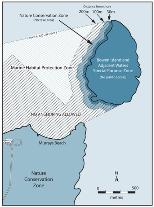
Map 4: Location of the marine component of the nature conservation zone

Performance indicators
- Ratio of Indigenous employees (employed directly and under contract) to non-Indigenous employees
- Traditional owners’ level of satisfaction in relation to implementation of the plan and the Training Strategy and conduct of Community liaison activities.
Performance under first plan
The technical audit of the first plan identified a stable trend in relation to decision-making processes that support joint management. High levels of direction and accountability were provided by both the plan and the Board, ensuring the park was able to remain focused on implementing the plan. Park staff also provided high quality information to the Board via regular reports.
Aims
- Parks Australia and Booderee’s traditional owners work together using established processes to manage Booderee to the highest standards for protection of natural and cultural values and provision of quality visitor services.
- Booderee’s traditional owners are able to meet their obligations to country and satisfy their aspirations for benefits from land ownership.
Background
The Director and the Wreck Bay Aboriginal Community Council have entered into a legally binding agreement, a 99-year lease, to jointly manage the park. The Lease protects the rights of the traditional owners to access and use the park and sets out the requirements for the Director to manage the park. The full provisions of the Lease at the time of preparing this plan are provided at Appendix B.
Managing the park involves making joint decisions on a range of issues and at a range of levels. The Board, with a majority of representatives of the traditional owners, is established under the EPBC Act. Its functions are to prepare management plans, make decisions on management of the park consistent with the plan, monitor the management of the park and advise the Minister on all aspects of the park’s future development. The Director is established under the EPBC Act and has functions and powers under the Act to manage the park in accordance with this plan.
In preparing management plans the Board has to make decisions that take into account the interests and aspirations of the traditional owners, the need to protect and conserve the park and the interests of the wider community. Whilst this management plan provides broad strategic direction, there are day-to-day decisions and processes which require input from the Council. In accordance with the Lease, the Director funds the Council for the purpose of fulfilling Community liaison functions; since 2005, those functions have been provided by a team of members employed by the Council. The Community liaison team meets with the park management team on a regular basis and makes decisions on day-to-day management issues; more complex matters may be referred to the Wreck Bay Board and/or Park Board for advice.
The concerns of Council members are represented by the Wreck Bay Board. In general, members of the Wreck Bay Board have been nominated by the Council for membership on the Park Board. The Council’s concerns are wider than park management and extend into Community development, housing and other social issues. Although not directly the responsibility of the Director, these issues and how the Community deals with them have an impact on the joint management arrangements and their success. They are also of broader government interest, with a strong relationship to programs aimed at improving health and social outcomes for Aboriginal people. The Council’s focus on park issues often relates to its aim of achieving outcomes that enhance the economic development of the Wreck Bay Aboriginal Community.
The implementation of joint management at Booderee continues to evolve. The success of joint management depends on a number of things, including implementation of this second management plan for Booderee, which reflects the objectives and provisions of the Lease and the aspirations of the Wreck Bay people; further development of a shared decision-making relationship; and the increasing involvement of the Wreck Bay people in managing the park.
The Australian Government provides a range of services and assistance to Indigenous people and communities. The park works with government, regional partners and the Community to identify and pursue sources of possible alternative funding and support for the park and for the Community.
Issues
- Clear and accountable decision-making mechanisms between the Council and the park are needed.
- A high level of liaison needs to be maintained between the Council and the park.
Prescriptions
Policies
4.1.1 When implementing this plan, the Director will take into account cultural sensitivities within the park including cultural sites and places, cultural artefacts and resources, and the cultural sensitivities of Community members.
4.1.2 Whilst the Director is responsible for the day-to-day management of the park through the Park Manager, the Director will be guided by the Booderee Board of Management and will consult with and have regard to the views of traditional owners via the Council in accordance with this plan and the Lease.
4.1.3 The General Manager of the Council (or delegate) will be the first point of contact for the Park Manager for advice on appropriate consultation procedures with the Community on day-to-day issues that are not specifically identified under the Lease or this plan, to be put to the Council or the Booderee Board of Management.
4.1.4 Decision-making will be consistent with:
(a) the EPBC Act and EPBC Regulations
(b) the IUCN protected area category and applicable reserve management principles that the park and each zone are assigned to by this plan
(c) management purposes of park zones, as per Section 3.1 of this plan, IUCN Category and Zoning
(d) the Director’s obligations under the Lease
(e) the processes shown in Table 5.
4.1.5 The Director will provide the Booderee Board of Management with the resources reasonably necessary for it to carry out its functions under the EPBC Act and to operate in such a way that it can express its views independently of the Director, and all members of the Board will continue to receive training in their legal and policy roles and responsibilities.
4.1.6 The Booderee Board of Management may establish consultative committees to advise the Board on issues of particular importance to the Board’s decision-making, with membership and terms of reference determined by the Board.
4.1.7 In accordance with the Lease, park staff will consult with individual Council members who are not members of the Booderee Board of Management only with the Council’s prior consent.
4.1.8 The Director will ensure park staff are familiar with joint management procedures and requirements.
Actions
4.1.9 In accordance with the Lease and in consultation with the Council, develop terms and conditions for delivery of Community liaison functions and regularly review performance of those functions against those terms and conditions.
4.1.10 As a priority, survey the views of the traditional owners to measure satisfaction levels with the park’s performance in relation to key aspects of joint management, based on the objectives of the plan, including employment and cultural heritage (see Table 9).
Table 5: Guide to decision-making
Category | Example | Decision-making process and consultation requirements |
Routine actions Actions that have no impact, or no more than a negligible impact, on the park’s environment and natural and cultural values; on the interests of Council members and/or stakeholders; and/or on visitor use or existing facilities and services in the park | - Minor capital works e.g. maintenance, replacement, repair or improvement of existing infrastructure in its present form
- Regular/routine ongoing operations to implement prescriptions in this plan e.g. patrols, weed control, fire management
- Minor new operations to implement prescriptions in this plan
- Issuing permits for regular activities in accordance with this plan e.g. commercial activities and research
| - Process accords with management plan policies, prescriptions and procedures and the park’s Manual of Procedures
- Council members and/or stakeholders are consulted where necessary and in accordance with Board guidelines
- Decision is made by appropriate officer
|
Non-routine actions Actions that have more than a negligible impact, or have a significant impact, on the park’s environment and natural and cultural values; on the interests of Council members, stakeholders and/or on visitor use or existing facilities and services in the park | - Moderate or major capital works e.g. new infrastructure or expansion/upgrade of existing infrastructure such as realignment of roads
- Rehabilitation of heavily eroded sites
- Major new operations or developments to implement prescriptions in this plan
- Developments for approved existing tourism activities that require major works
- Major/long-term changes to existing visitor access arrangements
- New types of commercial activities
- Issuing leases/licences
| - Process accords with management plan policies, prescriptions and procedures
- Council members and stakeholders are consulted where necessary and in accordance with Board guidelines
- Relevant stakeholders are consulted/informed·
- Decision is made by Board
|
Aim
- Traditional use and occupancy rights are exercised in a manner consistent with the Lease, the EPBC Act and this plan.
Background
The Lease provides for the members of the Council, as traditional owners of the park, to have the right to enter upon, use or occupy the park in accordance with tradition. This is subject to the prior approval of the Council, such reasonable constraints as may be contained in this plan and the directions or decision of the Board with respect to health, safety, privacy or protection of the park.
Section 359A of the EPBC Act states that the provisions of the Act and EPBC Regulations dealing with activities in Commonwealth reserves do not prevent traditional use of land by an Aboriginal person for non-commercial hunting or gathering, provided it is done in accordance with other applicable laws.
The Lease provides that the Director will not transfer, assign, sublet, part with the possession of, or otherwise dispose of the park or any part thereof without the consent in writing of the Council and then only in accordance with this plan.
Issue
- Occupancy of the park may impact on the park’s natural and cultural values.
Prescriptions
Policies
4.2.1 In accordance with the Lease and the EPBC Act, Council members may continue to exercise their traditional rights, including hunting and food gathering and use of any area of the park for ceremonial and religious purposes, provided it is done in accordance with other applicable laws.
4.2.2 In accordance with the Lease, the Director will not transfer, assign, sublet, part with the possession of, or otherwise dispose of the park or any part thereof without the consent in writing of the Council and then only in accordance with this plan.
4.2.3 In accordance with the Lease, the Council reserves the right to request the Director to sublet any reasonable part of the park to a Council member where it is in accordance with the EPBC Act and this plan.
4.2.4 The Director may transfer, assign, or sublet part of the park (including possible future additions to the park) to assist the development of commercial activities supported by the Council and to regularise developments for management of essential services in the park (see also Section 9.5, Essential Services). If space is available, park buildings or parts of park buildings may be sublet to the Council.
4.2.5 Business and commercial activity proposals supported by the Council which require use and occupation of the park or part thereof will be assessed in accordance with the environment assessment guidelines established by this plan (see Section 9.8, How proposals will be evaluated).
Actions
4.2.6 Consistent with the Lease, allow for the use and occupancy of the park by Council members for traditional use, ceremonial and religious, and other approved purposes in accordance with guidelines approved by the Board.
4.2.7 In the first year of the plan, in consultation with the Council and the Board, prepare guidelines for traditional use of areas within the park, (including camping).

Performance indicator
- Between 80% and 100% of all park functions are managed by Wreck Bay Aboriginal Community Council within five years of the commencement of this plan
- Improved ratio of Indigenous employees (employed directly and under contract) to non-Indigenous employees
Performance under first plan
An average of 45 per cent of staff engaged as ongoing Australian Government employees in the park were Indigenous, and over $1.7 million in park services were outsourced to the Council in 2013/14 financial year.
Aim
- Responsibility for the provision of services and management of the park are transitioned over time to the Wreck Bay Aboriginal Community Council.
Background
In 1995 the Wreck Bay Aboriginal Community Council was granted freehold title to Jervis Bay National Park and the Jervis Bay annex of the Australian National Botanic Gardens. The area of the park and gardens was leased back to the Director of National Parks to jointly manage the park with the traditional owners of Booderee. Joint management arrangements aim to share knowledge and skills necessary to manage and conserve the cultural and natural values of the park, and to build capacity within the Wreck Bay Aboriginal Community-so that the park may eventually be managed solely by the Council within the term of the lease.
The 99 year lease between the Director and Wreck Bay Aboriginal Community Council (Appendix B) formally recognises the Council's long-term goal for self-sufficiency through the control and management of its own lands and acknowledges the need to support actions during the term of the lease to achieve that goal.
Taking into account the Director’s duties under the Public Governance, Performance and Accountability Act 2013 and Australian Government procurement rules, the lease requires the Director of National Parks to contract the Council's services and engage as many Community members as is practicable to provide services in and in relation to the park.
The transfer of responsibility for the provision of services in the park and eventual sole management of the park by Wreck Bay Aboriginal Community Council is in alignment with the Council of Australian Governments (COAG) National Indigenous Reform Agreement. The agreement aims to improve the economic participation of Indigenous people, through the provision of opportunities for Individuals and communities to benefit from the mainstream economy – real jobs, business opportunities, economic independence and wealth creation. Through such activities, the Australian Government strives towards closing the gap on Indigenous disadvantage.
In pursuit of improving joint management arrangements across Parks Australia, the Director commenced a Joint Management Futures Project in 2014. The project aims to determine tailored joint management frameworks for Uluru-Kata Tjuta, Kakadu and Booderee National Parks, better suited to contemporary circumstances and evolving aspirations of traditional owners in relation to the benefit they derive from the joint management relationship,
Issues
- Joint management arrangements could be improved through a review of current arrangements and adopting new and innovative approaches.
- The Council is keen to progress towards sole management of the park and a roadmap towards this goal is required to ensure effective management of the park throughout any transition period.
Prescriptions
Actions
5.1.1 Consult with the Council and the Board with regard to possible new approaches for management of the park.
5.1.2 Consider practical steps for maximising existing joint management outcomes for Council members including employment, commercial and management opportunities.
5.1.3 Work with the Council and the Board to develop a long term roadmap and strategies to build capacity for traditional owners to enhance employment opportunities, foster Indigenous business development and ensure economic benefit from effective management of the park.
Aims
- Employment of Council members is facilitated in all areas of park management.
- Relevant vocational training is provided for Council members.
- Professional skills relevant to the management of the park are developed and maintained.
Background
Education and training is seen by the Council as a key to achieving Council aspirations of sole management and economic security. Employment directly with the park or through services provided to the park is a significant step towards realising this goal.
Support for training Council members was among the commitments made to the Community as part of the joint management negotiations (see Key Issues for the Wreck Bay Aboriginal Community, p. 10). Under the Lease the Director has, subject to the plan, specific obligations concerning employment and training for traditional owners. These are:
- within six months of the commencement of the Lease to establish and implement a program for training reasonable numbers of the Community in skills relevant to the administration, management and control of the park
- to contract the Council’s services and engage as many Community members as is practicable to provide services in and in relation to the park.
To fulfil these obligations, the Director has engaged a training manager whose duties include assisting in the provision of relevant training for members of the Council. A Training Committee has also been established to advise the Board on priority areas for training and employment. During the first plan, a Training Strategy for 2005–2010 was endorsed by the Board and implemented to build capacity within the Council, the park and the Council’s key business arms.
In addition to providing training to employees, the park’s training and employment initiatives have targeted Council members not currently in the workforce including primary, secondary and tertiary students. Work placements through programs such as the Community Development Employment Program have provided opportunities for Council members to develop skills in land management, become familiar with park management objectives and to stay and work on their country. The provision of a Junior Ranger Program (see Section 6.1, Protecting and Promoting Culture and Knowledge) has engaged pre-school and primary students from Jervis Bay School in cultural activities with elders, and work experience opportunities for high school students have supported students-at-risk programs to encourage school retention.
Two trainee positions were maintained in the park during the first plan including an executive trainee and a horticultural trainee. Trainees were supported with formal and on-the-job training. Vocational training in conservation and land management, tourism, business and horticulture has been completed by park staff and Council members. The park has also established exchange programs with other Parks Australia jointly managed parks.
These initiatives have resulted in an average of 45 per cent of park staff being Indigenous people employed as ongoing Australian Government employees; many more Council members are employed indirectly through contracted park services. The expansion of service level agreements with the Council’s business arm has increased the range of contracted services to include road and fire trail maintenance, entry station services and cleaning park and staff facilities. These contracts are worth around $1 million to the Community annually.
It has been a long-standing Australian Public Service (APS) policy to regard roles with a strong involvement in issues relating to Indigenous Australians as ‘Identified Positions’. All Booderee National Park positions are Identified Positions. The park applies two specific selection criteria in its recruitment processes which require applicants to have an understanding of the issues affecting Indigenous Australians and an ability to communicate sensitively with Aboriginal and/or Torres Strait Islander people.
‘Special Measures’ provisions are used in the APS to allow for the targeted recruitment of Indigenous Australians while adhering to the employment principles set out in the Public Service Act 1999. The purpose of ‘Special Measures’ is to improve employment outcomes for Indigenous Australians and to ensure that the diversity of the APS workforce reflects that of the Australian community.
Staff employed under the Public Service Act 1999 are subject to a range of employment conditions and legislation applicable to members of the department and the APS. Recruitment to APS positions is based on the merit principle in accordance with the Public Service Commissioner’s Directions 1999.
Issues
- Resources are needed to meet traditional owner visions of full employment for Council members in the park.
- Park workforce numbers are declining.
- School retention rates are of concern.
- More coordination is needed between service providers to maximise resources and improve employment outcomes.
- Pathway programs for transition from school to employment are needed to support the Council in assuming more responsibility in park management.
- Obstacles reducing the participation of Council members in training programs and applying for park vacancies need to be identified and addressed.
- Leadership and management skills need to be developed to improve progressions of Aboriginal staff to higher level positions in the park.
- Increased business management skills are needed to support and encourage small business developments and partnerships.
Prescriptions
Policies
5.2.1 The Director will strive to maximise the employment of Council members at all employment levels within the park.
5.2.2 Consistent with the Lease, the Director will continue to provide employment opportunities for Council members through contracting park services, casual staffing arrangements, staffing exchanges and recruitment to full-time park positions.
5.2.3 To increase Indigenous representation in the park, the Director will apply a ‘Special Measures’ provision to the recruitment of positions in accordance with government policies and procedures and the Director’s legal obligations.
5.2.4 Council members will have access to and be encouraged to participate in training and employment activities initiated by the park.
5.2.5 The park’s Training Strategy will continue to identify employment and training opportunities and targets for traditional owners in the park, the Council’s business arms and the Council. The park will review the Training Strategy and regularly report to the Board on its implementation.
5.2.6 Training positions in the park, the Council’s business arms and the Council (both internally and externally funded) will be filled by Council members wherever possible and occupants will be encouraged to undertake appropriate external study.
5.2.7 Aboriginal staff employed in the park will be encouraged to develop their management and leadership skills and work towards gaining higher levels of employment.
5.2.8 In accordance with the Lease, the Director will consult with the Council or its nominee concerning procedures for selection and appointment of permanent staff and contractors in the park.
5.2.9 In accordance with the Lease, the Director will promote among non-Aboriginal staff a knowledge and understanding of, and respect for, the traditions and culture of Council members.
5.2.10 The Director will provide opportunities for Council members to develop skills relevant to park management through, but not limited to:
(a) developing career pathways for Council members to engage in park management opportunities
(b) providing a calendar of training and career development activities for the park, the Council’s business arms and Council staff, as well as for Council members not currently employed
(c) developing work experience and school-based apprenticeship opportunities in the park for Council members still at school or engaged in tertiary studies
(d) maintaining partnerships with other relevant training providers and employment agencies in delivering training and employment initiatives
(e) seeking staff exchanges and placements with other jointly managed parks and relevant institutions.
5.2.11 Recognising the value of cultural maintenance, the Director will support the intergenerational transfer of traditional skills and knowledge valued by the Council through training initiatives and support for junior rangers.
Actions
5.2.12 Continue to employ a training manager who will coordinate staff training and career development (with particular emphasis on Aboriginal staff) and will assist the Council to coordinate training activities consistent with the Director’s Lease obligations.
5.2.13 Continue to maintain and support the Board’s Training Subcommittee with the principal functions of guiding the Board in setting training priorities and directions and implementing the training strategy. The Council will be represented on the subcommittee and the training manager will be a member of the subcommittee.
5.2.14 Provide opportunities for staff and Council members not currently employed to participate in a calendar of training for the park, the Council’s business arms and Council members. Training will aim to meet work safety requirements and develop skills in park management.
5.2.15 Support the career development, retention and promotion of Aboriginal staff within the park, the Council’s business arms and the Council through targeted training. Activities shall include training in leadership and management skills and staff exchange programs between the park, the Council’s business arms and the Council.
5.2.16 Establish and maintain partnerships with key government agencies and training organisations to provide opportunities for training and employment initiatives for the Council.
5.2.17 Provide training in recruitment processes to foster joint participation in staff selection and to assist Council members and staff applying for jobs.
5.2.18 Liaise with relevant local schools and the Council to establish opportunities for work experience and school-based apprenticeships in the park and the Council.
Aim
- Council’s goals are respected and where possible community opportunities for business development are supported under the plan.
Background
During the life of the first plan Wreck Bay Enterprises Limited, the commercial arm of the Council, entered into a contract with the Director to provide a number of services in the park (including road maintenance, cleaning services and operation of the entry station). The company was disbanded at the end of 2010 and its functions are now undertaken by the Council. The development of further agreements covering a wider range of park management activities is envisaged over time. This approach represents one significant contribution to the Council’s sole management goal.
Under the Lease the Director has, subject to the plan, a specific obligation ‘to encourage appropriate business and commercial enterprises by the Council and Community members within the park’. During the life of the first plan the Council indicated its interest in using the Botanic Gardens as a base for developing business activities and in taking a greater role in management of the Botanic Gardens. This approach is consistent with the Council’s goal of environmentally sustainable development as an economic base for the Community. Options for achieving a staged transfer of management responsibility have been discussed by the Director and the Council during the development of this plan and will be further developed as the plan is implemented.
Issue
- Support for business and commercial enterprises needs to be effective and feasible.
Prescriptions
Policies
5.3.1 In accordance with the Lease, development of appropriate business and commercial initiatives and enterprises by the Council and by individual traditional owners in the park will be encouraged, provided they are consistent with the key objectives of this plan.
5.3.2 Subject to relevant Commonwealth legislation and policies, park work programs may be carried out by contract and preference may be given to the Council and the Council’s business arms in providing contracted services.
Actions
5.3.3 Investigate any proposals from the Council or individual traditional owners to develop commercial activities in the park that are consistent with this plan and provide support for such proposals as provided for under this plan.
5.3.4 Within the first two years of this plan establish a timeframe for further contracting out of park work programs.

Performance indicators
- Improved trends in plant species diversity in selected fire sensitive vegetation communities
- Improved trends in population of selected threatened and significant species
- Reduction in trends for distribution and abundance of selected invasive species
- Within the first year of this plan an appropriate cultural heritage strategy is developed for consideration by the Board
- Traditional owners’ level of satisfaction with implementation of cultural heritage strategies and cultural site management.
Performance under first plan
The technical audit of the first plan identified a stable trend in relation to cultural heritage management: cultural sites were protected from park activities however site conservation works were not conducted and promotion of cultural themes was delayed subject to development of the cultural heritage strategy.
The technical audit of the first plan identified overall stable or positive trends in relation to natural heritage management. Visual attributes of landscape were protected, with no significant developments. Erosion control measures on unsealed roads and carparks were significantly improved. Landscape assessments were included in environmental impact assessment processes. Water quality monitoring indicated high and stable water quality and seagrass remained healthy at greater depths than at similar locations elsewhere. Excellent fox control with associated biodiversity outcomes was achieved. Bitou bush control programs were enhanced with good results but this weed continues to represent a serious threat to the park’s biodiversity.
Vegetation communities were maintained through proper use of fire and pest management. However, on the negative side, a number of species became locally extinct and this is likely to continue with clearing and development on the Bherwerre Peninsula isthmus. The incidence of large wildfires appeared to increase, possibly as a result of hotter and drier summers, leading to ecological impacts and infrastructure damage.
A positive trend was identified in relation to the Botanic Gardens living collection, where well-trained staff utilised good horticultural practices and cultural education programs to promote and educate visitors. Significant work was completed on Aboriginal interpretive gardens and further direction from cultural heritage strategies will allow completion of works under way.
Research recorded a positive trend. Research capacity and output were significantly boosted via a grant from the Australian Research Council. A wide range of research indicated high conservation values and strong natural heritage management performance.
Booderee National Park is home to the people of Wreck Bay who have a strong relationship with their country that is expressed through ongoing traditions, cultural practices, beliefs and knowledge. Management and use of the land by past and present generations have helped to shape the landscapes we see today.
The traditional owners have a strong sense of belonging to the landscape and they wish to be more involved in caring for their country through joint management of the park. They particularly wish to enable all knowledge holders to pass on cultural knowledge and traditions to future generations.
Traditional owners want to see cultural information and site records appropriately and safely collected, stored and used. It is important to the traditional owners that protocols and processes for protecting cultural heritage and cultural sites are in place and implemented.
Traditional owners will guide and be involved in all aspects of managing the park’s natural and cultural heritage. Traditional owners and Parks Australia will work together, sharing knowledge, to look after country through proper fire management, and managing weeds and feral animals. Traditional owners wish to use specific areas of the park for customary purposes and to explore opportunities for traditional owners to gain economic benefits from country.
Opportunities for younger generations of Wreck Bay Aboriginal Community Council members to gain knowledge about and be involved in caring for country will be a priority in all these activities.
Results of past wildlife surveys indicate that Booderee’s terrestrial and marine native fauna is diverse and abundant. A number of animal species listed as threatened or migratory under Part 13 of the EPBC Act occur in the park and in addition several listed marine species from a range of groups (for example, seals, birds, turtles, sea-horses and sea-dragons) are either known or expected to occur there.
The management of terrestrial fauna is closely linked to the management of vegetation communities. The park’s diverse vegetation communities include relict rainforest, littoral rainforest, forest, woodland, wet and dry heath, coastal scrub and grassland communities. Extensive seagrass beds are a feature of the park’s marine component and mangroves are also present.
Bowen Island requires a distinctive management approach in light of its unique vegetation communities and significance as seabird breeding habitat. Although the use of fire to manage Bowen Island was excluded under the first plan, future management may require use of fire to maintain the island’s natural values.
The living collection of the Booderee Botanic Gardens contains open ground plantings of some 1,200 taxa, which are cultivated and displayed to facilitate the study, conservation, promotion and enjoyment of Australia’s plant heritage, concentrating on species of the coastal regions of south-eastern Australia.
Climate change represents a major threat to the park’s cultural and natural heritage. Traditional owners want both traditional and scientific knowledge used to ensure the park’s cultural and natural heritage values are available to future generations.
Aim
- Culture and cultural knowledge are protected and maintained with traditional owners guiding their management and use.
Background
Aboriginal people play an active and significant role in shaping the heritage of Booderee. The Wreck Bay Aboriginal Community’s association with the area is evident today in knowledge of sites and significant places, oral history and storytelling, together with strong family connections and associations to specific areas of the park. It is important to traditional owners that this association is maintained for future generations.
Aboriginal cultural heritage at Booderee includes physical cultural heritage such as shell middens and camp hearths as well as oral history and cultural associations with the landscape.
There have been several studies on physical Aboriginal heritage conducted in the area of the park (Sullivan 1977, Navin and Officer 1993, Sachs 1997). Other studies have recorded the cultural association and importance of the area to the Aboriginal people of Wreck Bay (Egloff 1981, Egloff, Navin and Officer 1995).
A time capsule was installed at Green Patch in July 1998 at the ceremony for renaming the park. The time capsule is to be re-opened when the Lease expires in 2094.
During the life of the first plan a Junior Ranger Program was initiated, aimed at educating young Community people about local Aboriginal culture as well as the natural values of Booderee. The program operates under a Memorandum of Understanding between the Director and the Jervis Bay Primary School and aligns with school curricula. The program’s objectives are in keeping with the park’s joint management philosophy and the provisions and obligations of the Lease (see also Section 5.2, Community Development, Employment and Training).
The Director may prohibit or restrict access to all or part of a Commonwealth reserve (r.12.23)
Issues
- Traditional owners want to have input and guide decisions about cultural heritage management programs and priorities and to protect their cultural knowledge and materials.
- There is a need for ongoing cross-cultural training for all staff.
- Documentation of oral histories and traditional knowledge is urgently required to avoid generational loss of knowledge and culture with the passing of older Community members.
Prescriptions
Policies
6.1.1 Cultural heritage will be managed in accordance with national principles and international conventions and agreed park and Council cultural heritage strategies.
6.1.2 A whole-of-peninsula approach to the management of Aboriginal cultural heritage will be supported in which traditional owners have an active role in all aspects of management.
6.1.3 In accordance with the Lease, the maintenance of the Community’s Aboriginal traditions will be encouraged.
6.1.4 The Director may approve the temporary closure of the park or certain areas within the park if necessary for cultural reasons, in accordance with the Lease and advice from the Board.
6.1.5 The cultural knowledge and skills of traditional owners will be applied in developing and implementing natural and cultural heritage management programs.
6.1.6 The Director will support traditional owners through provision of training and resources to enable traditional owners to guide management of cultural heritage resources and programs within the park.
6.1.7 Staff development programs will include annual cross-cultural training, and cultural knowledge and skill development will be important components of staff development.
Actions
6.1.8 The Director will work with traditional owners to identify special cultural places that can provide opportunities for specific cultural activities by the Community.
6.1.9 Within the first year of this plan, establish a Cultural Heritage Officer position within the park.
6.1.10 Within the first year of this plan, work with the Council to develop an appropriate cultural heritage strategy for consideration by the Board.
6.1.11 Following approval by the Board, implement and periodically review the cultural heritage strategy for the park.
6.1.12 Support an oral history project aimed at developing a comprehensive account of previous land use and management practices in the Booderee area. Such information will assist in park management decision-making and also be used for interpretation programs.
6.1.13 Support participation of the Council in programs to conserve Indigenous languages.
6.1.14 Identify Booderee clearly as Aboriginal land via signposting, interpretive material and activities.
6.1.15 Continue to support the Junior Ranger Program.
Aim
- Through working with traditional owners, Aboriginal sites of significance are identified, protected and maintained.
Background
There are several kinds of sites and places within the park that are especially significant to the traditional owners. These sites reflect and express Aboriginal cultural beliefs and practices.
Sites presently recorded in the park include tangible sites such as middens, axe grinding grooves and scarred trees and non-tangible (to non-Aboriginal people) places such as natural landscape features associated with creation stories, or places where bush foods were found.
Wreck Bay traditional owners recognise that the protection of sites and places is very important for the survival of culture and for meeting responsibilities for managing country.
The Jervis Bay Territory is Commonwealth Heritage listed in recognition of natural values and of Aboriginal sites of significance which demonstrate the historic and ongoing Aboriginal occupation of the park and changes in cultural practices over time.
During the life of the first plan, the park commissioned a report on the cultural sites of the Bherwerre Peninsula which included a database, site photographs and a status assessment (McKenzie 2003).
Issues
- Cultural sites need to be protected from disturbance.
- Cultural artefacts need to be kept and protected.
- Agreed arrangements between the Council and the park for protecting sites, visitor access, recording, monitoring and managing cultural sites need further development.
- An appropriate interpretive program is needed for park visitors in relation to sites and cultural landscape features.
- Commonwealth Heritage values within the park need to be maintained.
Prescriptions
Policies
6.2.1 Archaeological sites will be managed to preserve them from disturbance and only essential protection activities will be allowed.
6.2.2 In accordance with the Lease, sacred sites, areas and things of significance to the traditional owners will be protected.
6.2.3 Sites will not be actively interpreted without consultation with and approval of the traditional owners and only if the protection of the site can reasonably be guaranteed.
Actions
6.2.4 Provide support to the traditional owners to develop the skills to manage the culture and cultural knowledge of Booderee.
6.2.5 In consultation with the Council, Defence and other Territory landholders, establish a register of sites of Aboriginal significance, linked to the park’s geographic information system. The register will include appropriate levels of access for security purposes. It will assist management in identifying sites during planning.
6.2.6 Negotiate arrangements with the Council for a possible keeping place for protecting artefacts.


Aim
- Post-contact historic sites in the park are adequately recorded and conserved.
Background
The historic use and occupancy of the Booderee area includes fishing, whaling, navigation, grazing, tourism, Aboriginal occupation, Defence activities, logging and plantation forestry. Significant shared cultural heritage of the Booderee area includes the historic Cape St George lighthouse which was completed in 1856 and demolished in the early 1900s; Christians Minde settlement and cemetery (dating from 1890 and not within the park); a historic grave located in the Green Patch camping area; archaeological evidence of a camp used by survivors of the 1835 wreck of the convict ship Hive which lies in NSW waters off Bherwerre Beach; gun emplacements and associated infrastructure on Bowen Island; an abandoned excavation for a nuclear reactor site near Murrays Beach; and a quarry and railway easement for the HMAS Creswell break-wall built in 1915.
Members of the Wreck Bay Aboriginal Community and other Kooris were actively involved in developing this shared heritage; they are proud to have been involved in this shared cultural heritage and it has special significance to them. Kooris not only worked alongside non-Aboriginals in the construction and development of many projects during the early settlement of the area but also developed strong associations and friendships with the early settlers. Kooris assisted with building the lighthouse and were friends with the lighthouse staff. They assisted with constructing Christians Minde and helped rescue people from the Hive.
The Cape St George lighthouse complex and Christians Minde settlement were included on the Commonwealth Heritage List in 2004, having previously been listed in the Register of the National Estate. The lighthouse is managed in accordance with a conservation strategy and significant conservation works have been carried out. The Christians Minde cemetery has been managed in accordance with the wishes of the relevant family. Other significant historic sites have had only limited management, such as fencing for site protection. The gun emplacement and associated structures on Bowen Island are inaccessible to the public and some of these structures are overgrown with vegetation.
Issues
- There are costs associated with maintaining historic sites.
- Commonwealth Heritage values within the park need ongoing maintenance.
- There are sites of historic heritage significance located outside and near the boundaries of the park which are vulnerable to human impacts and are accessible by park visitors.
Prescriptions
Policies
6.3.1 Historic heritage will be conserved in consultation with traditional owners.
6.3.2 Visitor facilities and interpretation materials may be developed at significant historic sites. Interpretation will include both Aboriginal and European historical perspectives.
6.3.3 The park will liaise with and provide advice to the New South Wales Government agency responsible for the management of heritage sites which are located on or near the park boundaries in accordance with Section 8.1, Neighbours, Stakeholders and Partners.
6.3.4 Where appropriate, the park will erect and maintain suitable protective measures to regulate public access to historic sites, including the Commonwealth Heritage listed Cape St George lighthouse.
Actions
6.3.5 Maintain a register of historic heritage sites in the park including conservation work undertaken and, where appropriate, seek to have sites entered on relevant registers and databases.
6.3.6 Implement management programs to identify, protect, conserve, present and transmit the values of historic heritage sites in the park, and to manage public access and use of historic sites including:
(a) gun emplacements on Bowen Island
(b) Cape St George lighthouse and surrounds
(c) Christians Minde cemetery
(d) Harriet Parker’s grave at Green Patch
(e) relics associated with the Hive and other historic shipwrecks.
Aim
- The visual attributes of the park landscape are protected, and degraded landforms are rehabilitated to minimise soil loss and erosion.
Background
Cultural landscape
The Booderee landscape is an ancient cultural landscape, one shaped by land management practices and traditions over many thousands of years. Culture and traditions remain and can still be felt and experienced today though some have changed. Throughout the landscape is the evidence of Aboriginal occupation and use of the land. At the landscape level, it is likely fire management was practised over a broader scale and with greater frequency than is possible today which would have led to a more open landscape with different vegetation communities being dominant compared to the landscape we see today. Weeds and pests can impact at the landscape level, so can tracks and roads which impact upon values such as the park’s exceptional water quality. Although Booderee is renowned for its spectacular natural and ancient landscapes relatively free of visual scars, some vistas are marred by development such as towers or buildings on the skyline. Yet there is little doubt Booderee remains a landscape shaped by a living culture.
Visual attributes
Booderee’s scenic qualities are widely recognised and are important to the regional tourism industry and to local communities. The landscape encompasses a peninsula of native vegetation, scenic beaches and bays, and magnificent sandstone cliffs.
Comprising much of Bherwerre Peninsula, all of Bowen Island and the water and seabed at the southern end of Jervis Bay, Booderee offers visitors an opportunity to experience a variety of coastal settings. There are also a number of cultural and historical features, such as the historic lighthouse, which add to the park’s visual attributes.
Without careful planning, the visual attributes and the inspiring natural and cultural experience of the park can be disturbed. For example, the scars arising from excavations for a proposed nuclear power station at Murrays Beach in 1969 remain clearly visible. There are also a number of long-established Defence facilities adjacent to the park which impact on the region’s visual attributes.
Geology, landforms and soils
A comprehensive geological survey of the Jervis Bay region was completed in 1992. Jervis Bay forms part of the sedimentary rock formation on the southern edge of the extensive Sydney Basin system. Bedrock is exposed in cliffs and marine platforms, and there are minor exposures in creeks and dune areas. The Bherwerre Peninsula (of which Booderee occupies the major portion) is underlain with Permian sandstones, siltstone and conglomerates of marine origin; Lakes Windermere and McKenzie evolved when streams were blocked by sand. Bowen Island is composed of the same sandstone type as the peninsula and slopes sharply from cliffs on the eastern (oceanic) side down to sea level rock platforms on the western (Jervis Bay) side. The sandstone on the island is covered by windblown sand, which supports a range of vegetation communities.
Other features of geological interest in the park include fossil sites and exposed stone walls of a substantial quarry used to supply stone for the construction of the HMAS Creswell break-wall. The role of Booderee’s landforms and geology in the evolution of ecological processes and landscape features is also of particular scientific and educational interest.
Aboriginal stories explaining the origins or characteristics of species in the area include stories of a large wave depositing animals inland. The NSW coast shows dramatic evidence of mega-tsunamis, the best evidence of which occurs along a small stretch of coastline at Jervis Bay. The most compelling evidence of tsunami impact is manifested in the various boulder deposits. The boulders, many of which exceed two metres in diameter, are deposited in an overlapping fashion on the deeply fluted rock platform surface at Stoney Creek as well as other sites in the Jervis Bay region outside the park. There is also substantial evidence of older sands washed onto barriers within the bay and of sea caves formed at heights above storm wave attack.
Disturbance
The sandy soils of Bherwerre Peninsula and Bowen Island are unconsolidated and depend upon the presence of vegetation cover for stability. When vegetation is removed, the soils and sand dunes are readily eroded by wind, water and physical disturbance. In the low-lying western area of the park the soil is occasionally saturated. In this condition the soils can be easily damaged or eroded by disturbance.
Erosion in heavy traffic areas has been minimised by sealing main roads, building bridges and fords over natural watercourses, constructing graded walking tracks and maintaining unsealed roads through the construction of drainage ditches and by adding material to very sandy areas.
Some areas of the park require rehabilitation from the effects of past use. A former tip located near the Visitor Centre contains asbestos. An asbestos management plan for the site has been developed and implementation of the plan is continuing.
As noted in Section 2.4, mining operations are prohibited in the park except in accordance with this plan. Mining operations include any operations or activities connected with, or incidental to, the mining or recovery of minerals or the production of material from minerals, including prospecting and exploration for minerals (s.355(2) of the EPBC Act).
The EPBC Regulations prevent a person from introducing soil, stone or other earth materials into the park or fossicking in the park unless provided for by, and carried out in accordance with this plan (or authorised by a permit or under certain other conditions).
Issues
- Mineral exploration and mining could impact on landscape attributes.
- Areas of eroded and disturbed land require rehabilitation.
Prescriptions
Policies
6.4.1 Subject to Sections 5.4.2 and 5.4.3, mining operations will not be allowed in the park.
6.4.2 Prospecting, fossicking or exploration for minerals may be carried on for scientific research purposes only and under conditions provided for in Section 6.12, Research and monitoring.
6.4.3 Extraction of gravel and sand from existing pits for park management purposes may continue. Stockpiled materials (such as sand and sawdust) may be used within the park.
6.4.4 Any new developments in the park will maintain the park’s high-quality visual landscape attributes.
6.4.5 Resource management activities in the park will particularly take account of the general low soil fertility, the drainage characteristics and the inherent instability of certain areas, especially sand dunes and aeolian sands near dune crests.
6.4.6 Landscaping materials including road fill, sand, rocks and organic material may be brought into the park subject to assessment of potential environmental impacts in accordance with Section 9.8, How proposals will be evaluated.
Actions
6.4.7 Where required, rehabilitate or allow for natural revegetation of eroded and disturbed areas of park land.
6.4.8 Develop and implement management plans for contaminated materials and sites in the park, such as asbestos in old tip localities.
Aim
- The marine ecosystems within the park are protected and maintained.
Background
Marine and freshwater ecosystems of the Jervis Bay region are central to the spiritual connectivity of the Wreck Bay Aboriginal Community.
The park is an ideal location for visitors to explore and safely enjoy the marine environment. The park is renowned for its shallow, clear waters that are easily accessible and often protected from wind and waves. Though the marine area of the park is relatively small, the park currently supports five commercial operators specialising in diving, snorkelling, and whale and dolphin watching. The area is well used by dive clubs and independent recreational divers.
The park showcases one of the most biologically diverse ecosystems on Australia’s east coast. Its natural values have been recognised by research scientists as ‘exceptional’ and fish species richness is one of the highest in temperate Australia (Aquenal 2004). The park supports a diverse range of marine habitats including the intertidal zone, extensive areas of seagrass, sandy bottom habitat and subtidal rocky reef.
Booderee’s marine waters are known habitat for the critically endangered grey nurse shark (Carcharias taurus). At least four other species of shark are known to use breeding sites within the park and it is a permanent nursery area for Port Jackson shark (Heterodontus portusjacksoni). Intermediate rocky reefs provide habitat for the iconic weedy seadragon (Phyllopteryx taeniolatus) and serve as breeding aggregation sites for southern calamari (Sepioteuthis australis). The park’s marine environment also provides food resources for the white-bellied sea-eagle (Haliaeetus leucogaster), which is of considerable significance to the traditional owners, as well as for little penguins and a range of other birds.
The park and the Wreck Bay Aboriginal Community wish to preserve the considerable values of the park’s marine environment for future generations. Booderee National Park, including its waters, is classified as IUCN category II (see Section 3.1, Assigning the Park to an IUCN Category and Zoning) to protect natural biodiversity along with underlying ecological structure and supporting environmental processes.
The park will expand its research and monitoring programs to evaluate the effectiveness of current management arrangements for conserving marine biodiversity. The research programs will aim to collect information about species, habitat and community biodiversity, while also identifying species of significance. Findings will inform management decisions relating to fishing practices in the park (see Section 7.8, Recreational fishing and collecting activities).
Issues
- Off-park activities may affect marine water quality.
- Recreational fishing and collecting may be negatively impacting on marine values.
Prescriptions
Policies
6.5.1 Use of the marine environment will be managed to protect, conserve and appreciate habitat and species.
6.5.2 Appropriate research and ecosystem monitoring will continue to be undertaken and/or permitted in order to develop a more comprehensive body of information on the park’s marine biodiversity.
6.5.3 Activities in the park will be undertaken in a manner that minimises sedimentary runoff and pollution of the marine environment.
Actions
6.5.4 Maintain liaison with relevant land managers and cooperate with the Jervis Bay Territory Administration, Defence, the Council and other Territory landholders to minimise the impact of pollution or runoff from developed areas on the marine environment.
6.5.5 Undertake and support relevant research into the marine environment including taxonomic research in relation to undescribed species and research into ecological processes.
6.5.6 Impose further restrictions on access or activities if a negative impact on marine values is observed, or areas of high habitat value or regional significance are identified as requiring additional protection. See also Sections 3.1.9 and 7.8.3.
6.5.7 Investigate mapping the benthic marine habitats of park waters to provide a resource comparable to vegetation mapping already available for the park’s terrestrial component.
6.5.8 Conduct education programs about marine environment values and the protection regime that applies.
6.5.9 Negotiate arrangements with the NSW Jervis Bay Marine Park for collaborative management of Jervis Bay.
6.5.10 Give high priority to the cooperative development, with other regional management agencies, of a marine monitoring program, collaborative research and a geographic information system to assist in conservation management of Jervis Bay.
Aim
- The freshwater ecosystems within the park are protected and maintained.
Background
The park’s freshwater systems range from ephemeral sheet and stream surface flows to permanent and semi-permanent streams, swamps and waterholes. Lake Windermere and Lake McKenzie are closed freshwater dune lakes and the largest permanent water bodies in Booderee. Both are characterised by considerable cyclical water-level fluctuations in response to climatic variations over a period of several years.
Alteration to catchment drainage patterns in swamp and wet heath areas can change the structure and composition of vegetation in the park.
Both lakes are used for water supply purposes. Lake Windermere is the water supply for the Jervis Bay Territory and its catchment is located within the park. The lake and its catchment are well protected from disturbance but the impact of water removal on the lake ecosystem is unknown. Water is pumped from Lake McKenzie for watering the Botanic Gardens, with excess water returning by surface and groundwater flow. As well as excessive water extraction, freshwater systems in the park are potentially at risk from excessive use of chemicals and fertilisers and from inappropriate recreational use.
Regulation 12.14 of the EPBC Regulations prohibits water, air and land pollution in the park and Regulation 12.15 prohibits use of a pesticide, herbicide or other poisonous substance in the park unless provided for by this plan.
Issues
- Off-park activities may affect water quality.
- There may be a risk to the quality and sustainability of the Jervis Bay Territory’s water supply.
Prescriptions
Policies
6.6.1 Use of chemicals, fertilisers and grasses in public use areas will be minimised to protect water quality and the health of native vegetation.
6.6.2 Construction activities, including maintenance of roads and tracks and grassed areas, will be planned to minimise, and where possible avoid, impact on watercourses and water quality.
6.6.3 No artificial surface water interception structures such as dams or weirs will be constructed in the park.
6.6.4 Swimming, recreational boating, fishing and harvesting organisms in freshwater bodies of the park will not be allowed unless as part of an approved research program (see Section 6.12, Research and monitoring).
6.6.5 Lake Windermere will be closed to public access in order to safeguard the potable water supply.
6.6.6 Activities including construction and prescribed burning that have the potential to accelerate sediment flow into Lake Windermere will incorporate necessary mitigation measures.
6.6.7 Park management activities that potentially disturb catchment drainage systems will be subject to assessment as outlined in Section 9.8, How proposals will be evaluated.
6.6.8 Water conservation principles will be applied to all water use in and by the park (see Section 9.9, Resource Use in Park Operations).
6.6.9 Proposals to provide supplementary or alternative supplies of potable water may be considered and any associated works will be subject to assessment under the processes outlined in Section 9.8, How proposals will be evaluated.
6.6.10 Appropriate research and monitoring of freshwater quality and ecosystems will continue to be undertaken or permitted in order to develop a more comprehensive body of information on the park’s freshwater resources and their particular management requirements.
Actions
6.6.11 Maintain liaison with relevant public health, pollution control and water supply authorities and cooperate with the Jervis Bay Territory Administration, Defence, the Council and other Territory landholders to minimise pollution of water bodies through seepage from sewerage systems, runoff from developed areas or saltwater intrusion.
6.6.12 Liaise with the Jervis Bay Territory Administration regarding any plans to consider alternative sources of water supply for the Jervis Bay Territory other than Lake Windermere.
Aims
- Fire is managed within the park to protect life and property and to maintain, conserve and enhance biodiversity.
- Indigenous fire management practices are integrated into park fire management.
Background
Fire is a natural feature of Booderee. Although only a limited amount is known about the pre-European fire regimes of coastal NSW, traditional Aboriginal fire management was dynamic and very important in shaping the composition of the area’s flora and fauna.
Photographs taken within the area of the park in the late 1800s and early 1900s suggest that fire was used by European settlers as a means of modifying pasture and gaining access through thick coastal heath. Considerable environmental problems occurred at Bherwerre Beach and Bowen Island as a result of this frequent fire regime, the primary examples being dune destabilisation and changes in vegetation community composition.
In 1972, two-thirds of the then Jervis Bay Nature Reserve (45 per cent of the current area of the park) was burnt by wildfires. In response, the then Department of Territories set up permanent vegetation monitoring sites within a range of different vegetation types. In 1976, extensive vegetation surveys for the reserve were completed (Ingwersen 1976) and a vegetation and fire management strategy commenced the following year.
In 1997, a consultant was commissioned to update previous vegetation surveys and revisit the monitoring sites and to make recommendations on the management of fire for vegetation communities and significant plant species (Taws 1997, 1998). The resulting reports form an important part of the fire planning process for Booderee and recognise that the ongoing use of fire is essential to the survival of some plant communities. The reports made recommendations on fire regimes, fire intensities and fire frequency thresholds for all broad vegetation communities in the Territory. In 2000 these recommendations were revised by consultants for the Fire Management Program 2000–2004 to make the park’s fire management strategy more consistent with fire management planning applied in NSW.
The park’s fire management program is updated every five-years and details fire management priorities including bushfire risk management works (particularly prescribed burning), trail maintenance, and protecting assets and neighbouring land. The fire management program is supported by annual fire action plans. The Council has a complementary fire management plan for Wreck Bay village.
The most recent fire management program was expanded to include a focus on managing the invasive weed bitou bush (Chrysanthemoides monilifera), using a spray-burn-spray program. At the Botanic Gardens, a fire break is maintained around the perimeter fence and fire hydrants have been installed in some vulnerable areas to help exclude wildfires from the living collection.
Fire research
Research into the effects of fire on both plant and animal communities is an ongoing requirement. In December 2003 about half of the park was burnt by wildfire, over a similar area to that burnt in 1972. The Australian National University began a fire ecology research project in the park the previous year and this fire brought about changes in the design of the project which became a longer-term investigation of the effects of fire on the park’s ecology. The project was extended for a further five years in 2008.
The project’s results have provided valuable insights into the response of animals to wildfire. Overall, the study found that the December 2003 wildfire had relatively little impact on the park’s mammal fauna. Long-nosed bandicoot (Perameles nasuta) numbers increased in burnt and unburnt areas, while bush rats (Rattus fuscipes), swamp rats (R. lutreolus) and Antechinus stuartii declined in burnt areas. Of the arboreal mammals ring-tailed possums (Pseudocheirus peregrinus) and greater gliders (Petauroides volans) declined but brush-tailed possums (Trichosurus vulpecula) increased.
These results differed substantially from other published results on the impact of fire on native mammals, possibly due to an interaction between fire and effective fox control at Booderee. Similarly, the Australian National University project found that eastern bristlebirds (Dasyornis brachypterus) recovered from the 2003 fire very quickly compared to other studies of the impact of fire on this species. The researchers put this rapid recovery down to the presence of small unburnt patches and few foxes to prey on disoriented and exposed birds following fire. However, less positively, the project noted that at individual sites throughout the park, bird species diversity declined by nine per cent for every additional fire each site received (planned or unplanned) since records on fire history were first kept in 1972. In contrast, reptiles showed very little impact from the 2003 wildfire or from fire frequency.
The increase in fire frequency and intensity which is forecast in climate change models is likely to be a significant threat to Booderee’s biological diversity as well as to life and property. Species that are most vulnerable to an increase in fire are likely to be those least able to adapt to rapid change or those left without suitable habitat to move to as climatic parameters shift. Significant impacts are anticipated within rainforest and swamp oak forest habitats, as well as wet heaths and creek-line swamps. Climate change impacts may also have implications for planned burning, with variations in temperatures and potential changes in rainfall patterns resulting in fewer opportunities to undertake safe and effective planned burns (see also Section 6.11, Climate Change).
Legislative requirements and operational response
Under the EPBC Act the Director is responsible for fire management in Commonwealth reserves. Fire management includes all fire operations along with planning and undertaking bushfire risk management works. The Rural Fires Act 1997 (NSW) (JBT) applies to Booderee to the extent that it is consistent with, and can operate concurrently with, the EPBC Act and Regulations. A Fire Action Plan is developed annually which outlines the statutory responsibility and organisational structure of Booderee National Park Brigade, as well as establishing procedures and guidelines for the park’s response to fires.
Cooperation with regional agencies is central to effective management of fire in the park. Under a Memorandum of Understanding between the Director and the Commissioner of the NSW Rural Fire Service signed in 2002, the Director is recognised as the responsible fire authority for the management of class 1 fires in the park. In the event of a multi-agency class 2 fire, the Jervis Bay Territory Emergency Management Committee will appoint an Incident Controller. In such an event, Jervis Bay Territory and NSW Rural Fire Service brigades are likely to be allocated to provide assistance. Conversely, Booderee National Park Brigade may be called upon to respond to fires outside the park.
Booderee is resourced for fire fighting with tankers, light units, a fire shed, incident control room and trained staff. Volunteer units also operate at Wreck Bay and Jervis Bay villages and Christians Minde locality. A range of park policies to promote safe and environmentally sound fire management operations are in place (including policies on training, personal fire protection, use of chemical retardants and use of heavy machinery) and are regularly reviewed.
The management of fire use by visitors is covered by the EPBC Regulations. Under the Regulations a person must not light, maintain or use a fire in the park while a total fire ban declared by the Director is in force; light, maintain or use a fire at any other time except in a portable barbecue or stove, a fireplace provided by the Director, a fireplace of a kind approved by the Director or a place approved by the Director; leave a fire unattended; or use any fuel for a fire that is prohibited under this plan.
Issues
- There is a risk to park resources and assets from fire, including off-park fire management activities.
- Unplanned high-intensity fires may impact on life and property.
- There is a need to protect Booderee’s natural heritage, especially fire-sensitive species and communities.
- There is a need to protect Booderee’s cultural heritage, including Aboriginal sites of significance, archaeological sites and contemporary heritage.
- There is a need to protect Booderee’s recreational amenity, including viewscapes.
- Climate change may impact on fire frequency and intensity and have implications for management, particularly conservation of biodiversity.
Prescriptions
Policies
6.7.1 Fire will be managed in the park in accordance with the following principles:
(a) protection of human life and property within Booderee, Jervis Bay Territory and adjacent lands
(b) protection of the park’s cultural heritage, including Aboriginal sites of significance and historic places
(c) protection of the park’s natural heritage, especially threatened species, plant communities of special significance and fire sensitive species such as obligate seeders
(d) maintenance of a natural diversity of habitats for native fauna and flora
(e) incorporation where possible of relevant aspects of known Indigenous fire management practices.
6.7.2 Fire will be managed in accordance with the Booderee Fire Management Program, which is prepared every five years within the framework of the prescriptions established by this plan.
6.7.3 Fire operations will be conducted in accordance with the annual Booderee Fire Action Plan and with relevant legislation and park management policies.
6.7.4 All unplanned fires occurring in Booderee will be suppressed as quickly as possible unless allowing a block to burn out can be done safely and without compromising the park’s Fire Management Program.
6.7.5 Areas disturbed by fire suppression operations will be rehabilitated as soon as practicable after the operations are complete.
6.7.6 Prescribed burning programs will:
(a) include an assessment of environmental impact for each proposed burn in accordance with procedures established under Section 9.8, How proposals will be evaluated
(b) be conducted in areas of identified high bushfire risk in order to protect adjacent properties, cultural resources, park assets and facilities, and fire-sensitive vegetation
(c) aim to maintain a viable proportion of each vegetation type in as old an age class as possible
(d) be used to control weeds provided an appropriate post-fire response is planned
(e) assess the reproductive status of indicator plant species as recommended in Taws (1998).
6.7.7 Pre-burn planning will take into account the ecological guidelines set by Taws (1998) regarding minimum and maximum fire period thresholds and fire intensities, together with climate change information, fire ecology research and park fire research.
6.7.8 As far as possible, fire will be excluded from the following fire sensitive areas:
(a) rainforest communities
(b) mangrove and saltmarsh communities
(c) swamp forest
(d) wet sclerophyll forest
(e) coastal fore-dune grasslands
(f) fire sensitive cultural resources and sites.
This exclusion policy will be reviewed for each new fire management program.
6.7.9 Fire access will be managed as follows:
(a) Strategically critical access tracks will be maintained to a high standard of access, safety and stability.
(b) Tracks of lesser importance will be maintained in a stable and trafficable condition as far as resources permit and in accordance with assigned priorities.
(c) Unnecessary tracks will be identified, closed and allowed to revegetate.
Actions
6.7.10 Maintain, implement and regularly review policies on fire management operations and in particular policies on fire training, fire personal protection, use of chemical retardants and use of mechanical machinery.
6.7.11 Continue to assist the Council to develop knowledge and skills in fire fighting, fire management and planning and incident control.
6.7.12 Maintain liaison with the Jervis Bay Territory Administration, rural fire services (Jervis Bay Territory Rural Fire Service and NSW Rural Fire Service), the NSW National Parks and Wildlife Service, Defence and other fire management authorities to ensure coordination of fire management. Continue as a member of the Jervis Bay Territory Emergency Management Committee and the Shoalhaven Bushfire Management Committee.
6.7.13 Prior to the start of each fire season, prepare a Fire Action Plan in consultation with the Council, the Jervis Bay Territory Administration, the Jervis Bay Territory Rural Fire Service, Defence, lessees and members of the Jervis Bay Territory Emergency Management Committee. The Fire Action Plan will outline the organisational structure and responsibility of Booderee National Park Brigade and standard operating procedures and guidelines for response to bushfires in Booderee and the Territory, including Wreck Bay village.
6.7.14 Prepare a Fire Management Program every five years (or more frequently as required) in consultation with members of the Jervis Bay Territory Emergency Management Committee. The program will include descriptions and maps of proposed burns and trail maintenance requirements over the life of the program.
6.7.15 Refer each Fire Management Program for assessment of environmental impact in accordance with relevant provisions of the EPBC Act.
6.7.16 Based on the Fire Management Program, prepare, in consultation with members of the Jervis Bay Territory Emergency Management Committee, an annual bushfire risk management program detailing all proposed burns and trail maintenance requirements for the year.
6.7.17 Where appropriate, seek to involve neighbours in cooperative bushfire risk management works for mutual protection.
6.7.18 Continue to undertake or support research into the ecological relationships of fire within the vegetation communities in the park, including post-fire flora and fauna dynamics and vegetation communities’ responses to climate change and long-term vegetation changes resulting from fire regimes.
6.7.19 Monitor trends in plant species diversity in fire sensitive vegetation communities (see Table 9).
6.7.20 Monitor recently burnt areas close to known weed infestations for appearance of weeds and take prompt action to remove any long-term problem weeds at an early stage.
6.7.21 Prepare reports for all fires in a standardised format which will include maps, a summary of events, description of fire behaviour, weather conditions and other relevant information. Fire reports will be added to the fire history database and mapped onto the park geographic information system.
6.7.22 Add records of fires on Council land to the park geographic information system which will be made available to the Council for management purposes.
6.7.23 In consultation with affected parties, including lessees, develop an evacuation plan for the park.
Aim
- Protect, maintain and enhance viable populations of native plant and animal species and maintain vegetation communities.
Background
Because of its protected status and rich biodiversity, the park is considered a population reservoir for many species across the wider region. Other reservoirs in the area include Beecroft Peninsula to the north and Morton National Park to the west. It is important that these reservoirs are linked by a system of habitat corridors to ensure maintenance of species diversity and genetic viability. This is particularly significant for Booderee, which is linked to other areas by a narrow tract of land. The vegetation on the narrow ‘neck’ of the Bherwerre Peninsula is fragmented by the settlements of Hyams Beach and Erowal Bay/Wrights Beach. It is important for vegetation to be retained in the remaining parts of the ‘neck’ or isthmus as this area serves as a habitat corridor and is important for the park’s long-term protection.
Regional planning for the protection of habitat corridors has involved liaison with the NSW National Parks and Wildlife Service, NSW planning authorities and the Shoalhaven City Council. The Director, Parks Australia, the Council and the Board have expressed concerns about the possible fragmentation of this corridor and the subsequent impact it may have on the park’s biodiversity.
As noted in Section 2.4, Legislative Context, Part 13 of the EPBC Act prohibits and regulates actions in relation to listed threatened species and ecological communities, listed migratory species, cetaceans and listed marine species. Appendix E to this plan lists species of significance to the park, including species that are listed under the EPBC Act.
Actions taken in a Commonwealth reserve in accordance with a management plan in relation to members of species listed under Part 13 of the Act are exempt from prohibitions that would otherwise apply under Part 13.
Flora
Jervis Bay is at both the southern extremity of the temperate coastal (Sydney) flora and the northern extremity of the cool temperate coastal flora ranges. Booderee’s floristic diversity is consequently high, with a total of 625 native plant species being recorded in a 1997 survey (Taws 1997).
The park’s diverse vegetation communities include relict rainforest, littoral rainforest, forest, woodland, wet and dry heath, coastal scrub and grassland communities. Extensive seagrass beds are a feature of the park’s marine component and mangroves are also present. At least four vegetation communities are listed as endangered ecological communities under the NSW Threatened Species Conservation Act 1995 (swamp oak forest, littoral rainforest, freshwater wetlands and bangalay sand forest).
One plant species—magenta cherry (Syzygium paniculatum)—listed as threatened under Part 13 of the EPBC Act occurs in the park. The pretty beard orchid (Calochilus puchellus), which is listed under the NSW Threatened Species Conservation Act, has also been recorded. A number of other plant species which occur in Booderee have significant conservation status and warrant special protection because they are at the edge of their range (Taws 1997), have limited distribution or are considered rare (Briggs and Leigh 1996). A number of other plant species occur in the park that, although not necessarily threatened, may warrant particular management consideration due to their iconic status. Such species include waratahs, rock orchids and elkhorns (see Appendix E).
Bowen Island requires a distinctive management approach in light of its unique vegetation communities and significance as seabird breeding habitat. Although the use of fire to manage Bowen Island was excluded under the first plan, future management may require use of fire to maintain the island’s natural values.
Fauna
Results of past wildlife surveys indicate that Booderee’s terrestrial and marine native fauna is diverse and abundant. More than 30 mammal species, some 200 bird species, 37 reptile species, 17 amphibian species and at least 180 fish species have been recorded in the area of the park.
A number of animal species listed as threatened or migratory under Part 13 of the EPBC Act occur in the park and in addition several listed marine species from a range of groups (for example, seals, birds, turtles, sea-horses and sea-dragons) are either known or expected to occur there (see Appendix E). Management reflects the conservation requirements of these species: the Fire Management Program, for instance, provides specific guidelines for each relevant threatened fauna species.
The park is a stronghold of the nationally endangered eastern bristlebird (Dasyornis brachypterus), with probably the largest population (approximately one-third of all individuals of the species) occurring on the Bherwerre Peninsula. In 2004, in accordance with recommended recovery strategies, a small number of birds from the Bherwerre Peninsula (including the park) were successfully translocated to Beecroft Peninsula. At the time of preparing this plan, this additional Jervis Bay population appears to have become established.
During the life of the first plan the nationally vulnerable green and golden bell frog (Litoria aurea) apparently became locally extinct in the park due to chytridiomycosis, a fungal disease responsible for the decline of many amphibian species worldwide.
Sub-fossil remains indicate that southern brown bandicoots (Isoodon obesulus) (EPBC listed as endangered) and long-nosed potoroos (Potorous tridactylus) (EPBC listed as vulnerable) were once abundant in the Jervis Bay region. The principal threatening process for these species is predation by foxes and, following effective fox control in Booderee, a proposal was made to reintroduce these species. Suitable habitat and disease-free populations have been examined and the proposal to reintroduce the species under the prescriptions of the first plan was approved by the Board in 2008.
A large number of species listed under the NSW Threatened Species Conservation Act have been recorded in the park including the ground parrot (Pezoporus wallicus), powerful owl (Ninox strenua), eastern pygmy-possum (Cercartetus nanus) and pied oystercatcher (Haematopus longirostris) (see Appendix E). Of particular importance are several pairs of hooded plovers (Thinornis rubricollis) which are the northernmost breeding population of this species. Shorebirds and long-nosed bandicoots (Perameles nasuta) are the species monitored most closely to test the effectiveness of the park’s fox control program.
A growing seal colony at Steamers Head and a large and very successful breeding colony of little penguins (Eudyptula minor) on Bowen Island which is regularly monitored are among the most significant marine species in the park. A number of cetacean species are regularly sighted in Jervis Bay including in park waters. The most prominent are a resident pod of bottlenose dolphins (Tursiops truncatus) while humpback whales (Megaptera novaeangliae) and southern right whales (Eubalaena australis) sometimes enter the bay while on annual migration along Australia’s east coast. As marine mammal numbers grow, the possibility of strandings in or near the park may increase.
Research by park staff has indicated that macropods are very abundant in the park following intensive fox control and that macropod browsing is limiting the recovery of a number of native plant species especially following fire. If this trend is maintained, the park’s vegetation structure may be fundamentally altered. Grazing and trampling by macropods also poses a significant threat to the living collection of the Botanic Gardens where management has concentrated on preventing grazing through meshing susceptible plantings; in 2009 the Board approved the installation of a macropod-proof fence around the collection.
The management of terrestrial fauna is closely linked to the management of vegetation communities. Ongoing fauna management has involved ecological studies of wildlife and populations; feral animal and weed control programs; fire management; and the adoption of a vegetation management program (see also Section 6.7, Fire). Marine fauna management has focused on patrol and law enforcement. Park staff may also be called upon to deal with injured wildlife.
A number of entrenched visitor activities affecting wildlife are inconsistent with conservation of the park. These include feeding wildlife, collection of bait and shellfish from rock platforms and private specimen collecting. Such activities are currently managed through visitor education and compliance activities.
Issues
- Invasive and overabundant native species may impact upon biodiversity.
- There is a need for a better understanding of the taxonomic status of a number of locally endemic species.
- Strengthened regional cooperation is required to manage biodiversity and threatening processes.
- Ability for fauna to move in and out of the park may be impacted by fragmentation of corridors linking the park to other natural areas.
- Inappropriate fire regimes affect fauna and flora.
- Entrenched visitor activities may impact on native fauna.
Prescriptions
Policies
6.8.1 The Director may take actions concerning native species, including species listed under Part 13 of the EPBC Act, that are otherwise prohibited by the EPBC Act where they are necessary to implement this Plan, or where they are otherwise necessary for preserving or protecting the Park, protecting or conserving biodiversity, or protecting persons or property in the Park.
6.8.2 The Director may carry out research and monitoring that involves actions covered by ss.354 and 354A of the EPBC Act in relation to members of native species.
6.8.3 The Director may issue a permit to bring plant material into the park.
6.8.4 The supply of native plants and plant material by the Director to people or organisations outside the park is undertaken in accordance with the provisions of this plan and written agreement with the Director.
6.8.5 Taking of native plant and animal species that involves access to biological resources will be managed in accordance with Section 6.12, Research and monitoring.
6.8.6 Species of plants and animals that are significant to the park (Appendix E) will be the focus of management programs. Species will be selected for conservation action on the basis of conservation and cultural significance, ecological function and available resources.
6.8.7 Where possible ecosystem approaches will be adopted to conserve biodiversity.
6.8.8 Flora and fauna research undertaken or sponsored by the park will primarily be directed at supporting and assessing the effectiveness of management programs.
6.8.9 Previously occurring native species may be reintroduced to the park, subject to approval by the Board.
6.8.10 Injured or otherwise distressed animals will be managed as follows:
(a) Animals may be removed from the park by staff for rehabilitation.
(b) Financial support may be provided to local wildlife carer organisations where appropriate.
(c) Return to the park of rehabilitated animals originating from the park will be considered on a case-by-case basis.
(d) Release in the park of rehabilitated animals not originating from the park will require the approval of the Park Manager which will be subject to an evaluation of suitable genetic, territorial and habitat factors.
(e) Animals may be euthanised if necessary.
6.8.11 Nuisance native animals will be relocated wherever practical and may be euthanised if no other solution is feasible.
Actions
6.8.12 Seek authorisation under relevant NSW legislation to allow for cooperation with adjacent management agencies in the protection of flora and fauna.
6.8.13 Work closely with the Council and, where appropriate, Defence and the Jervis Bay Territory Administration, to adopt a peninsula-wide approach to conservation management of vegetation corridors.
6.8.14 Continue to liaise with NSW agencies and the Shoalhaven City Council to actively promote the maintenance of vegetation corridors regionally.
6.8.15 Continue to liaise with neighbours to encourage the conservation of native species and communities across legal boundaries.
6.8.16 Monitor population trends for selected threatened and significant native species (see Table 9).
6.8.17 Incorporate relevant actions from threat abatement and species recovery plans into park management programs.
6.8.18 Consistent with climate change strategies for the park (see Section 6.11, Climate Change) continue to monitor species or communities likely to be most at risk from impacts of climate change and identify options to improve their resilience.
6.8.19 Develop a conservation program for Bowen Island that includes:
(a) identification of natural and cultural heritage values
(b) ecological monitoring of seabirds and other fauna
(c) identification and management of key threatening processes
(d) fire management
(e) infrastructure development and maintenance activities.
6.8.20 Incorporate information on native flora and fauna into the park’s geographic information system. This may include information on land owned and managed by the Council and will be made available to the Council for management purposes.
6.8.21 Investigate options for the management of over-abundant macropods in the park.


Aims
- Manage a living collection that aids understanding and appreciation of the flora of the coastal region of south-eastern Australia with an emphasis on Aboriginal plant use.
- Continue to develop the Botanic Gardens as an example of good landscaping and horticultural practice.
Background
Establishment of the present living collection of coastal south-eastern Australia flora began in the 1950s with the development of the Booderee Botanic Gardens as a frost-free annex to the Australian National Botanic Gardens. Members of the Wreck Bay Aboriginal Community made a major contribution to developing the Botanic Gardens and most households have had members who worked there between the 1960s and the present.
The original role of the Botanic Gardens has shifted with the transfer of ownership to the Council and formal inclusion of the Botanic Gardens in the park. Increasing emphasis has been given to representing the regional flora (with the ‘region’ being defined as south-east coastal Australia east of the Great Dividing Range) and to Indigenous plant use.
The Botanic Gardens living collection contains open-ground plantings of some 1,200 taxa which are cultivated and displayed to facilitate the study, conservation, promotion and enjoyment of Australia's plant heritage. In the past, planting has focused on five broad themes: taxonomic; horticultural; ecological and geographic; ethnobotanical; and conservation.
Development of the living collection has been largely confined to the region north and north-east of Lake McKenzie. Surrounding native vegetation has been retained; it provides good examples of local plant communities and species and establishes the landscape setting of the Botanic Gardens. Firebreaks are maintained along the perimeter fenceline, and fire hydrants have been installed within the fenceline adjacent to Cave Beach Road and at the Windermere gate. A weed control program aims to prevent non-local plants spreading into the adjacent natural vegetation. Watering the living collection relies on water pumped from Lake McKenzie which is subject to considerable fluctuation in response to rainfall (see also Section 6.6, Fresh water).
Following completion of the first plan a collection policy for the Botanic Gardens was developed and was approved by the Board in 2003. The policy provides for its review in line with development of this second plan.
During the life of the first plan, a proposal for establishing a Koori Garden educational trail was developed by a consultant and presented to the Council. Implementation of the proposal has been delayed subject to the Council’s ongoing consideration of appropriate cultural heritage strategies it wishes to see pursued in the park.
Under the EPBC Act (ss.354 and 354A) a person must not kill, injure, take, trade, keep or move a member of a native species in the park except in accordance with this plan. The EPBC Regulations also contain provisions that regulate the introduction of animals and plants to Commonwealth reserves and the cultivation of plants in reserves.
Issue
- Future development of the Botanic Gardens needs to reflect Aboriginal ownership.
Prescriptions
Policies
6.9.1 The Director may take actions concerning native species, including species listed under Part 13 of the EPBC Act, that are otherwise prohibited by the EPBC Act where they are necessary to implement this Plan, or where they are otherwise necessary for preserving or protecting the Park, protecting or conserving biodiversity, or protecting persons or property in the Park.
6.9.2 The Director may carry out research and monitoring that involves actions covered by ss.354 and 354A of the EPBC Act in relation to members of native species.
6.9.3 Native plant material may be taken in and from the Park in accordance with a permit issued under the EPBC Regulations.
6.9.4 Taking of native plant and animal species that involves access to biological resources will be managed in accordance with Section 6.12, Research and monitoring.
6.9.5 The living collection will be managed in accordance with the Booderee Botanic Gardens collection policy and will use ethnobotanical themes to support interpretive programs in the Botanic Gardens.
6.9.6 In consultation with protected area management agencies and botanical institutions, threatened plants from the region will be included in the living collection.
6.9.7 Plants or plant material may be brought into the park for the purpose of supplementing the living collection. Plants or plant material supplied by the Director may be taken from the park with the written agreement of the Director.
6.9.8 All wild-sourced living collection accessions will be represented by voucher specimens in the Australian National Herbarium to verify their identity and for incorporation into the Integrated Botanical Information System database at the Australian National Botanic Gardens.
Actions
6.9.9 Develop a master plan for the Botanic Gardens.
6.9.10 Review the Booderee Botanic Gardens collection policy.
6.9.11 Establish a Koori Garden educational trail in the Botanic Gardens.
Aims
- Strategically manage weeds and introduced animals to retain the park’s natural and cultural values and prevent invasion by new species.
- Increase the understanding and involvement of all stakeholders in managing weeds and introduced animals.
Background
Introduced fauna
There are 13 known introduced terrestrial vertebrate species in the park: rabbits, foxes, cats, dogs, two rodent species and seven bird species. Following the eradication of rabbits from Bowen Island in 1979 and rats from the island in 1993, the numbers of introduced vertebrate pests in the park are relatively low and probably have little ecological impact overall.
The exception is the European red fox (Vulpes vulpes) which despite highly successful control remains a threat, particularly to small and medium ground-dwelling species. Predation by foxes is a listed key threatening process under the EPBC Act and a comprehensive control program in the park is ongoing. At the time of preparing this plan, control principally comprises monthly baiting using 1080 poison. The abundance of species known to be susceptible to fox predation is regularly monitored to test the effectiveness of fox control (see Section 6.8, Native Species).
Rabbits and introduced rodents can be a nuisance around developed areas of the park such as camping areas and the Botanic Gardens. Deer of several species represent a potential and emerging threat to park values.
Introduced flora
A total of 129 species of introduced flora have been identified in the park (Taws 1997). Some of these are native Australian species but are not native to the area.
Bitou bush (Chrysanthemoides monilifera) is the most significant weed in Booderee. Bitou is listed as a weed of national significance in the 2006 Australian Weeds Strategy and is also listed under the NSW Noxious Weeds Act 1993. Invasion of natural plant communities by bitou bush is declared a key threatening process under NSW legislation and a threat abatement plan for NSW was approved in 2006.
Bitou dominates the dune system of Booderee and also occurs in forest, woodland and coastal vegetation communities. The continuing spread of bitou into otherwise undisturbed native vegetation is a significant threat to the park’s ecological integrity. An integrated approach involving several methods of control is used in the park, including physical (fire, hand pulling), chemical (aerial and on-ground) and biological methods.
Other introduced plants in the park include castor oil plant (Ricinus communis), Kikuyu grass (Pennisetum clandestinum), dipogon vine (Dipogon lignosus), Madeira vine (Anredera cordifolia), conifer wildings (Pinus spp.) from past forestry operations and moth vine (Araujia hortorum); escaped garden plants from nearby residential areas represent a future threat to park values. Infestations of these plants are usually small-scale although control of Kikuyu on Bowen Island is regularly required to protect seabird nesting sites.
In the Botanic Gardens, some non-local native plants such as kangaroo paws (Anigozanthus spp.) and Cordyline stricta have become serious environmental weeds and occur outside the cultivated area. Native conifers planted as part of past forestry operations are also potentially invasive.
Some introduced species such as ribgrass (Plantago lanceolata) and inkweed (Phytolacca octandra) are used by traditional owners for medicinal purposes. Where these species are non-invasive, they do not present control problems for the park.
A weed management strategy is developed every five years for the park and includes profiles of the main weeds, prescriptions for their control and locations of infestations. The strategy is implemented by park staff and the volunteer group Parkcare. Under the strategy a bitou control plan is also prepared.
Pathogens
Chytrid fungus (Batrachochytrium dendrobatidis) has been implicated in the decline of many amphibian species worldwide and infection of amphibians with the chytrid fungus is a listed key threatening process under the EPBC Act. The apparent disappearance of the nationally vulnerable green and golden bell frog from the park during the first plan was attributed to this disease which may pose a threat to other amphibians in the park (Penman and Brassil 2008).
In the Botanic Gardens, attention to watering regimes has been the main method used to minimise the outbreak and movement of soil-based pathogens. A fungal pathogen, Armillaria luteobubalina, has been identified in a section of the Botanic Gardens and control strategies are being investigated.
Marine pests
Introduction of marine plant and animal pests has been a problem elsewhere and, with ships and boats coming into Jervis Bay, is a risk in the park. Marine surveys have detected the likely presence of an introduced marine worm at Murrays Beach boat ramp (Aquenal 2004) and the marine alga Caulerpa taxifolia is found in St Georges Basin adjacent to the park.
The EPBC Regulations regulate the introduction of animals and plants to the park and the cultivation of plants in the park. The Regulations also prohibit unauthorised use or introduction of a pesticide, herbicide or other poisonous substance in the park unless carried out in accordance with this plan.
Issues
- Foxes are a significant threat to fauna (particularly small to medium-sized species) and control requires long-term commitment.
- Effective bitou control requires long-term commitment.
- Introduction of new weeds, pests and pathogens may pose a risk to the park.
Prescriptions
Policies
6.10.1 Control of weeds and introduced animals will be a high priority and will attract ongoing financial commitment with an identified budget.
6.10.2 Adopt best management practices for control of weeds and introduced animals, with preference given to those prescribed in threat abatement plans and/or identified as Weeds of National Significance.
6.10.3 Chemical control of weeds and introduced animals may be carried out but effects on non-target species and the park environment will be minimised.
6.10.4 Opportunities for potential weed species to be introduced to the living collection of the Botanic Gardens will be minimised.
6.10.5 Action may be taken to remove or control any marine pests found in the park, in cooperation with other authorities involved in management of Jervis Bay as necessary.
Actions
6.10.6 Regularly update the weed management strategy during the life of this plan. The strategy will detail weed sites, control prescriptions, monitoring actions and resources required and will be assessed in accordance with the guidelines for assessment procedures.
6.10.7 Maintain an integrated bitou bush control program and monitor its effectiveness, amending control methods as required.
6.10.8 Seek to establish a weed management committee for the Territory to encourage a peninsula-wide approach to weed control, particularly on Territory leases, and to inform the Board on relevant weed matters.
6.10.9 Develop a control strategy for introduced animals including emerging pest species such as deer. The strategy will include a review of existing protocols and will detail pest control needs and priorities, control prescriptions and monitoring actions.
6.10.10 Maintain a control program for foxes and monitor the program’s effectiveness, amending control methods as required.
6.10.11 Incorporate information on weeds and pest animals into the park’s geographic information system. This may include information about land owned and managed by the Council and will be made available to the Council for management purposes.
6.10.12 Liaise with the Council, Defence, Jervis Bay Territory Administration and Territory lessees on weed and introduced animal management matters. Provide technical assistance as required.
6.10.13 Consult with the Council in relation to control of potential medicinal weed species before control programs are undertaken.
6.10.14 Undertake or support appropriate further research into the impact and control of introduced species relevant to Booderee.
6.10.15 Regularly review and implement programs to prevent non-local plant species spreading from the Botanic Gardens living collection into the rest of the park.
6.10.16 Prevent the introduction of pests and pathogens to the Botanic Gardens living and non-living collections by regularly reviewing and updating practices and procedures.
6.10.17 Monitor the impact of pathogens on the Botanic Gardens living collection. Implement and regularly review the management program for the Armillaria-affected area of the Botanic Gardens.
6.10.18 Monitor the distribution and abundance of significant invasive species including foxes and bitou bush (see Table 9).
Aim
- Climate change impacts on park values are better understood and management actions and planning are adapted to take account of the latest available information.
Background
In recent years global warming and its implications for climate change has emerged as a key issue for biodiversity and environmental management on a global scale.
The park’s terrestrial and marine environments are potentially exposed to a number of impacts associated with climate change. The park is likely to experience increased annual average temperatures (with up to +4.0°C projected by 2070) and increased potential evaporation (with up to +17 per cent projected by 2070). Average sea level is expected to rise by 50 centimetres by 2070. Uncertainty regarding annual average rainfall is high; rainfall may increase or decrease but the number of days over 35°C (+15 by 2070) is projected to increase (Hyder 2008).
Climate change projections such as these suggest the park will be exposed to a range of challenges. Increased frequency and intensity of fire arising from a drier and hotter climate regime has particular implications for fire-sensitive vegetation communities. Some invasive species may be favoured by changes in climate, increasing the threats they already pose to native species and their habitats.
Marginal sea level rise may have impacts on the marine environment and may damage sensitive coastal areas such as Bowen Island. Additionally, increased storm intensity will have impacts on both marine and freshwater environments. For example, more frequent large storms may lead to direct loss of seagrass habitat as well as damage to areas critical for shore-nesting seabirds.
The impact of climate change can be lessened by ensuring that all existing threats to the park’s integrity are appropriately managed. Management of fire, weeds and pest species may need to be reviewed regularly under changing climatic conditions to assess and address resilience of species or habitats.
In 2006 the Director commissioned a study of the potential implications of climate change for managing Commonwealth reserves including Booderee (Hyder 2008). The results of this investigation have contributed to better understanding of and preparedness for changing conditions in the park and development of Parks Australia-wide and park-specific climate change strategies (see also Section 9.9, Resource Use in Park Operations).
Issues
- Climate change is likely to affect many aspects of the park including:
- biodiversity—changes in distribution and abundance of plants and animals and an increased risk that exotic plant and animal species will spread
- fire—changes in fire frequency and intensity
- Indigenous and cultural values—possible changes in access to certain food sources and impacts on cultural sites of significance
- water resources—future viability of a dependable water supply and any ecological impacts of reduced water levels
- human health—increase in heat-related illness and in injuries from extreme weather events.
- Up-to-date expert information is needed to assess the impacts and risks of climate change. Traditional owners and stakeholders need to be informed as knowledge of potential climate change impacts develops.
- Provision of adequate resources is required to implement climate change strategies.
Prescriptions
Policy
6.11.1 If parts of the landscape are changing in ways that are of concern, the Director and the Board, in consultation with relevant stakeholders, will jointly decide on further monitoring requirements and whether protective, rehabilitation or adaptation measures are feasible. If cost effective, appropriate responses and actions will be implemented.
Actions
6.11.2 Identify priorities for and support further research into the impacts of climate change on the park and use this information to refine decisions about acceptable change (see Section 6.12, Research and monitoring).
6.11.3 Where feasible, adapt management priorities and programs in response to improved understanding of climate change impacts. This may include:
(a) ecosystem and species management
(b) emergency response capacity, including wildfire management
(c) infrastructure design, planning, development and maintenance
(d) visitor management and safety.
6.11.4 Develop and implement a climate change strategy for the park that identifies appropriate changes to park management programs in response to improved understanding of climate change impacts.
6.11.5 Investigate possibilities for participation in national strategies for carbon farming, carbon trading or similar incentive schemes which may potentially provide revenue for the park. Subject to approval by the Board, implement such strategies where appropriate.
Aims
- Conduct, sponsor and support research that will lead to a better understanding of the natural and cultural heritage and use of Booderee and provide information that will contribute to effective management of the park and surrounding region.
- Identify any changes in the environment of the park and its use, to provide a way of measuring management effectiveness and to inform decision-making.
Background
Research and surveys provide baseline information and comparative data about the park’s resources, visitor use and human impact. Monitoring is an essential management tool for keeping track of changes to the environment and for measuring the success of and adapting management actions.
The park has considerable intrinsic scientific value as it contains overlapping bioregions in both the marine and terrestrial environments. As a consequence, many species are at either the northern or southern limit of their distribution. The park is used extensively by external researchers as it offers a relatively undisturbed coastal environment close to several research institutions. For some studies it provides a scientific reference area, or a pristine control for comparative experimentation. Integrated terrestrial/marine research is possible.
A number of research and monitoring programs are conducted in the park. Monitoring programs are in place for freshwater quality, abundance and distribution of species of conservation significance, abundance of indicator species, and feral species, and distribution and changes in vegetation following fire or over time. In 2008 the Australian National University agreed to a second five-year partnership, funded by the Australian Research Council, examining in detail the effects of fire and weeds on the park and recommending changes to their management (see Section 6.7, Fire).
The Lease requires the Director to make research reports in relation to the park available to the Council.
Under the EPBC Regulations research may not be undertaken in the park unless it is provided for by, and carried out in accordance with, a management plan in force for the park or is authorised by a permit, or under certain other conditions. Research which involves killing, injuring, taking, trading, keeping or moving native species or is undertaken for commercial purposes is prohibited by ss.354 and 354A of the EPBC Act except in accordance with this plan. Research which affects listed threatened species or ecological communities, listed migratory species, cetaceans or listed marine species must comply with Part 13 of the Act.
The Director has functions under s.514B of the EPBC Act to protect, conserve and manage biodiversity and heritage in Commonwealth reserves, and to carry out alone or in cooperation with other institutions and persons, and to arrange for any other institution or person to carry out, research and investigations relevant to the establishment and management of Commonwealth reserves. Research and monitoring programs assist in the development and adaptation of management programs for conservation of significant species.
Access to biological resources
Access to biological resources (also known as bioprospecting) is the taking of biological resources of native species for research and development on any genetic resources, or biochemical compounds, comprising or contained in samples or specimens of these species.
Access to biological resources in Commonwealth areas such as the park is regulated under the EPBC Act and EPBC Regulations. ‘Biological resources’ are defined as including genetic resources, organisms, parts of organisms, populations and any other biotic component of an ecosystem with actual or potential use or value for humanity. ‘Genetic resources’ are defined as any material of plant, animal, microbial or other origin that contains functional units of heredity and that has actual or potential value for humanity.
Part 8A of the EPBC Regulations regulates access to biological resources. Key features of Part 8A in relation to Booderee are set out in Table 6.
Access to biological resources is also covered by ss.354 and 354A of the EPBC Act if the resources are members of a native species and/or if access is for commercial purposes.
Issues
- Research and monitoring requirements need to be prioritised.
- Effective methods are needed for storing and retrieving research and monitoring information and results.
Prescriptions
Policies
6.12.1 The Director will undertake or encourage research and monitoring as indicated in the relevant sections of this plan and consistent with the objectives of this plan. Priority will be given to measuring the impacts of management actions in the park and improving management activities.
6.12.2 The Director will seek, and make every reasonable effort to allocate and secure, continuing funding for high priority research and monitoring projects in the park.
6.12.3 The Director may carry out research and monitoring that involves actions covered by ss.354 and 354A of the EPBC Act in relation to native species.
6.12.4 Other persons may carry out research and monitoring, including actions covered by ss.354 and 354A of the EPBC Act:
(a) in collaboration with the Director, under a formal written agreement
or
(b) in accordance with a permit issued by the Director.
6.12.5 Where appropriate, the Director will cooperate with the Council, Defence and other land management agencies for joint research and monitoring and for sharing the results of such activities.
6.12.6 Wherever practicable, park staff and Council members will be involved in monitoring programs.
6.12.7 Permits authorising research and monitoring may be granted if the activity:
(a) will not threaten the conservation status of a species
(b) will not affect culturally significant sites or species in a negative way
(c) does not kill or remove individual animals, unless a benefit to the species can be demonstrated
(d) does not kill or remove whole plants, unless a benefit to the species can be demonstrated.
6.12.8 Research and monitoring permits may be issued for a period not longer than five years.
6.12.9 Consultants or permittees may be required to communicate research findings to traditional owners.
6.12.10 Access may be provided to biological resources in the park in accordance with Part 8A of the EPBC Regulations and with written agreement from the Director.
Actions
6.12.11 Implement a research and monitoring program for the park. So far as possible the program will take an integrated and collaborative approach with other land management organisations within the Jervis Bay region.
6.12.12 Maintain a central (paper and electronic) registry of research and monitoring reports at Park Headquarters, with additional copies provided to the Council and the department’s library.
6.12.13 Continue to manage spatial and aspatial research and management data and develop improved access to data and information systems for park staff and the Council.
Table 6: Key features of the EPBC Regulations on bioprospecting as they concern the park

- Any person who wants to access biological resources must obtain a permit from the Minister.
- The ‘access provider’ must agree to the taking of biological resources. The access provider for Aboriginal land in Booderee National Park is the Council.
- Where access is sought for commercial purposes or potential commercial purposes:
- there must be a benefit-sharing agreement with the Council
- the benefit-sharing agreement must provide for reasonable benefit sharing arrangements, including protecting, recognising, and valuing any Indigenous people’s knowledge that is to be used
- the Council must give ‘informed consent’ to the benefit-sharing agreement before it can proceed, after the traditional owners of the land have been consulted and the views of the Council obtained.
4. Where access is sought for non-commercial purposes:
- written permission must be obtained from the Council
- a statutory declaration must be given to the Council declaring, among other things, that any biological resources taken are not intended to be used for commercial purposes, that a written report will be given to Council on the results of any research into the biological resources, that samples will not be given to other people (other than a specified research institution) without permission of the Council, and that the person(s) given access will not carry out, or allow others to carry out, commercial research or development unless a benefit-sharing agreement is in place with the Council
- there must be an environmental impact assessment of the proposed access if it is likely to have more than negligible environmental impact.


Performance indicators
- Trends in visitor numbers
- Trends in visitor revenue yield
- Levels of visitor satisfaction
- Levels of satisfaction of traditional owners with the park’s tourism directions.
Performance under first plan
The technical audit of the first plan identified largely stable or positive trends in relation to visitor management and park use. Visitor use remained high and stable and there were few adverse incidents involving visitors. Walking tracks and signage were improved to meet Australian Standards. Marine safety legislation was introduced into the park and additional boating facilities were installed (moorings) or upgraded (Murrays Beach boat ramp). Work was completed through the permit process to ensure tour operators understood and promoted the values of the park and of the Wreck Bay Aboriginal Community. A negative trend under the first plan was a significant and increasing level of illegal fishing, with a likely impact on biodiversity conservation.
Aim
- The tourism directions for the park:
- recognise Booderee as an important regional tourism destination, a place with a living Aboriginal culture and extraordinary natural values
- provide for tourism in the park which is environmentally sustainable and produces meaningful opportunities for the economic, social and cultural development of traditional owners, in accordance with the Council’s goals
- in accordance with the Council’s goals, recognise the park’s tourism principles
- build strong and successful partnerships with traditional owners, government and the tourism industry to help care for country and achieve sustainable tourism
- offer memorable and diverse experiences for visitors with insights into the park’s natural and cultural values.
Background
As owner of the lands and waters of Booderee, the Wreck Bay Aboriginal Community Council welcomes tourism opportunities that help visitors to experience the park’s natural environment and to learn about Aboriginal culture. The involvement of traditional owners in sustainable tourism initiatives can contribute to providing a secure economic base for the Community as well as an opportunity to teach visitors about the Community’s living culture.
Booderee is a major tourist destination for the NSW South Coast region. The park provides a unique set of recreational opportunities in scenic natural surroundings close to regional centres and the major cities of Sydney and Canberra.
In 2010 Booderee National Park was the first winner of the Best Conservation of Cultural Heritage category at the international Responsible Tourism Awards held in London. This was the first time an Australian destination had ever won one of the prestigious awards. The Indigenous tourism experience offered by the park has also been consistently recognised through state and national tourism awards.
The Director is represented on the South Coast Regional Tourism Organisation and park management also enjoys a close working relationship with other tourism bodies in the region, including the NSW National Parks and Wildlife Service, the NSW Marine Parks Authority, Tourism NSW and the Shoalhaven City Council. A tourism representative familiar with the Jervis Bay region is appointed as a member of the Booderee National Park Board of Management. The park’s contribution to tourism has been regularly recognised in regional, state and national tourism awards.
During the life of the first plan, the Board considered issues relevant to the park’s tourism future in some detail. A pre-design study for the proposed Cultural Centre was commissioned (Berkemeier 2004) and feasibility analysis for the provision of accommodation, food and retail services was undertaken (Enmark 2005a). A report on alternative pricing structures for park-use and camping fees (Enmark 2005b) was adopted by the Board in 2006.
The Board established a Visitor and Business Wellbeing Group in 2005 with a focus on preparing an integrated approach to the planning and development of a Cultural Centre and associated business opportunities for the Council and its members. The group initiated discussions on the need to develop a wider tourism vision for the park that included investigating the business case and options for the establishment of a Cultural Centre.
While passive nature-based recreation has been the park’s traditional tourism focus, especially during summer and holiday periods, there is increasingly a demand for a range of self-guided and commercial tourism experiences which reflect the wider values of the park, particularly its cultural values. Tourism initiatives of this nature could help address management issues of high visitor use at peak times by providing year-round recreational experiences. The active involvement of traditional owners is vital in ensuring the development and delivery of appropriate tourism activities in the park.
Issues
- High visitor use of the park and facilities during the summer and holiday periods impacts on visitor experiences, visitor satisfaction levels and park values.
- The park’s natural and cultural values need protection from visitor impacts.
- There is a need to support and provide meaningful tourism business enterprise opportunities for traditional owners.
- The privacy of Wreck Bay Aboriginal Community residents needs to be maintained.
Prescriptions
Policy
7.1.1 Tourism will be managed in accordance with the following principles:
(a) Planning for tourism should be an integral component of park management.
(b) Tourism development will not be at the expense of the park’s natural and cultural values or the privacy of the Community.
(c) Traditional owners will guide the nature of tourism development in the park.
(d) The visitor experience will emphasise the park’s natural and living cultural values and promote an appreciation of Aboriginal culture.
(e) Tourism development will recognise and support the Council’s goal of sole management of its land and waters.
(f) Provision of a range of business and employment opportunities for traditional owners will be an integral component of tourism planning.
(g) Visitor information, recreational opportunities, facilities and services will complement and support tourism management objectives for the surrounding region.
(h) Long-term sustainability in use of resources will be a determining consideration in tourism developments.
Actions
7.1.2 Within the first three years of this plan, in consultation with the Board and the Council, develop and implement a Sustainable Business Plan for the park which, drawing on previous studies, considers:
(a) appropriate visitor experiences
(b) site-specific tourism activities and opportunities
(c) business enterprise opportunities for the Council and its members
(d) promotion and marketing strategies for off-peak and shoulder seasons
(e) the range and use of visitor facilities
(f) the park’s carrying capacity
(g) how the park can be protected from adverse tourism impacts
(h) how tourism can support management of the park
(i) how tourism can meet the aspirations of traditional owners.
7.1.3 Implement and regularly review the Sustainable Business Plan.
7.1.4 Work in partnership with the Council to maintain strong working relationships with regional and state tourism organisations and agencies and to coordinate implementation of the Sustainable Business Plan.
Aim
- Promotion and marketing of the park presents accurate and appropriate information and images which:
- increase awareness of Aboriginal ownership and joint management
- promote higher revenue yield and off-peak visitation
- promote development of Indigenous business enterprises
- promote sustainable visitation to the park.
Background
Strategic promotion, marketing and media coverage can influence visitor awareness levels, numbers, length of stay, revenue yields and levels of satisfaction. Accurate promotion also helps to give people realistic expectations of their visit to the park.
Promotion and media coverage can help the Board communicate its messages to park visitors and to the general public and assist with gaining public support for the park and, more generally, for the management and conservation of natural and cultural heritage.
Park staff provide information and assistance to visiting journalists, tourism industry representatives, professional photographers and film crews to promote the park and its management. NSW Tourism, the South Coast and Shoalhaven Tourism Boards and other members of the tourism industry can also be major promoters and marketers of Booderee’s key values, as a regional visitor destination with nature-based and Indigenous tourism opportunities.
A variety of media outlets (newspapers, magazines and television) and conservation groups, researchers, professional photographers and filmmakers have already contributed positively to the name and images of Booderee being widely distributed, all with a particular focus on the park’s natural and cultural heritage values and recreational opportunities. There is scope to better target these messages and images to increase revenue yields and off-peak visitation and to achieve greater benefits for the Council.
A marketing plan completed for the park in 2006 in association with a restructure of park-use and camping fees (Hailey 2006) provides recommendations and a framework for an action plan/marketing strategy for the park more generally.
Issues
- The use of culturally appropriate images and the use of messages and promotions will create realistic expectations about a visit to the South Coast of NSW.
- Promotion and marketing of the park needs to be managed strategically and where appropriate in collaboration with other stakeholders.
Prescriptions
Policies
7.2.1 The park will be promoted and marketed in accordance with the Sustainable Business Plan with key messages to be determined or approved by the Board (see also Section 7.3, Visitor Information, Education and Interpretation).
7.2.2 The Director will seek to involve the promotional arms of the tourism industry locally and regionally to promote the park, Indigenous tourism enterprises and the key elements of the Sustainable Business Plan.
7.2.3 The Director will inform the tourism industry as soon as possible when changes are made to visitor management in the park that will affect tourism products and their promotion.
Action
7.2.4 As a high priority, in conjunction with the Board, develop and implement a promotions and marketing strategy to promote key elements of the Sustainable Business Plan (see Section 7.1.2).
7.2.5 In the first year of this management plan, review the schedule of park use fees for the park
Aims
- Booderee is accurately promoted and interpreted as an Aboriginal-owned, jointly managed national park where land and sea are managed together.
- Public understanding of the need for nature conservation and for protected areas is promoted along with a positive attitude toward nature conservation in Booderee.
- Commercial opportunities are provided for traditional owners in delivering information, education and interpretation services.
Background
Well prepared and distributed information enables people to plan their visit and enjoy Booderee in a safe and appropriate way.
Pre-visit information may come from a range of sources including publications, the tourism industry and online sources such as the Booderee web page on the Parks Australia website. The first point of contact for information for visitors arriving at the park is the entry station and the adjacent Booderee Visitor Centre. Static display boards are located at key visitation sites throughout the park; these display boards present environmental, safety and orientation information.
The park’s heritage is extremely diverse and provides a variety of opportunities for education and interpretation and for quiet enjoyment of intact marine and terrestrial natural environments. Guided walks and talks are conducted as formal scheduled programs during the school holidays and are available on request for schools and community groups at other times. A range of interpretive services are offered at different locations throughout the park including the Botanic Gardens, aimed at both the general visitor and specialist groups such as bird-watching or plant interest groups.
Under the Lease, the Director is required to promote knowledge and understanding of, and respect for, the traditions and culture of the Aboriginal traditional owners and to consult with the Council in respect of the formulation of any educational and interpretive policy.
The Council and individual traditional owners are integral to cultural interpretation. Council members have long been involved in interpreting Booderee’s environment, from generation to generation, as well as professionally in the park and in the Shoalhaven region. With the Community’s interest and experience in interpretation, Booderee is recognised as a place that can and does showcase cultural interpretation.
A set of Communication Guidelines which outlines the main themes and messages to be communicated in the park was developed in consultation with the Council. The guidelines define communication, set out the general goals of communication at Booderee, identify the audience and describe the main messages and themes to be communicated.
During the first plan progress was made in enhancing presentation of the park to visitors as an Aboriginal-owned place. The development with the Council of cultural heritage strategies for the park will allow further improvements to the presentation of the park and of its conservation and cultural messages.
Issues
- Meeting visitor demands for education and interpretive services within the available resources is a challenge.
- Visitors need accurate and culturally appropriate information about the park and its values, including Commonwealth Heritage values.
- Interpretive signs are required at a number of popular visitor sites to provide information about the values of the sites, orientation and safety.
- Interpretive and regulatory signs in the park should meet national standards.
- There is a need to enhance presentation of the park as Aboriginal-owned.
- Park visitors may need to be made aware of the appropriate use of and access to areas of Aboriginal-owned land in the Jervis Bay Territory which are outside the park.
Prescriptions
Policies
7.3.1 Education and interpretation programs will be conducted in accordance with the Booderee Communication Guidelines as updated from time to time.
7.3.2 Indigenous business enterprises involving cultural interpretation will be encouraged and supported by the park (see Section 5.3, Community Opportunities for Business Development). Council members will be encouraged to participate in implementation of interpretive programs in the park and may be engaged or contracted to deliver interpretive services in the park.
7.3.3 Only the Council or its representatives or park staff will be allowed to provide interpretive services in the park that concern Aboriginal culture and traditions.
7.3.4 Where interpretive services are provided to the park commercially, prescriptions concerning the conduct of commercial tour activities will apply (see Section 7.9, Commercial Tour Activities).
7.3.5 The Director, in consultation with the Board, may discuss with the Council administrative and financial arrangements for the development, promotion and delivery by the Council of interpretive activities undertaken within the park.
7.3.6 A park image reflecting Booderee as an Aboriginal-owned national park will be maintained across all interpretive and educational material.
7.3.7 Directional signs will be installed in accordance with the park sign manual and national standards and legislation, and will be sited appropriately to protect culturally important places.
7.3.8 The Park may install additional interpretive facilities in the park in response to interpretation and education requirements.
Actions
7.3.9 Continue to support the Board’s Education and Interpretation Subcommittee which will oversee development and implementation of education and interpretive activities in the park and report to the Board as required.
7.3.10 As a high priority update the Booderee Communication Guidelines to, in particular:
(a) reflect the outcomes of agreed cultural heritage strategies for the park
(b) promote clear and accurate messages to visitors regarding access to and enjoyment of Aboriginal land which is available to the public
(c) improve online provision of education and information.
7.3.11 Continue to research and present information on Indigenous plant use at the Botanic Gardens, in consultation with the Council.
7.3.12 Monitor the effectiveness of park communication and interpretation services and facilities via visitor surveys.
7.3.13 Continue to review place names used in the park during the life of the plan. Where practicable, place names will have the original Indigenous name next to the current common name.
7.3.14 Regularly review the park’s interpretive material and update information available to the public.
7.3.15 Investigate the feasibility of installing signage at the end of Deakin Street to inform visitors of relevant restrictions in the park—including camping, littering and the prohibition of domestic animals
Aim
- Visitors to the park enjoy a safe, sustainable and enriching experience while protecting the park’s natural and cultural values.
Background
There are approximately 400,000 visitors to Booderee per year, mostly from Australia and arriving by car. The warmer months and school holidays are the peak visitation periods and park facilities, especially camping areas, may be crowded.
Visitor activities in the park include camping, bushwalking and swimming, surfing and other beach-based activities; whale watching and other nature-based activities are also popular along with boating, snorkelling and scuba diving. The Botanic Gardens provides an opportunity for visitors to see representative samples of coastal plant species and to learn about Aboriginal plant use. A number of commercial boat and land tours operate in the park and are regulated under permit (see Section 7.9, Commercial Tour Activities).
Visitor surveys have found that summer visitors tend to rate ‘beaches’ as the park’s prime attraction whereas winter respondents focused more on the natural aspects. Visitor survey results also indicate that, while the proportion of first time visitors was the same summer and winter, there was a higher proportion of repeat visitors in winter. Overall, winter visitors are more satisfied with their visit than summer visitors.
Visiting the park, like other wild places and national parks everywhere, can have risks. Swimming and other water-based activities and rock fishing have the greatest potential risk. A range of measures are adopted by the park to reduce the risk to visitors including assessing tree safety at camping areas, maintenance of roads, tracks and visitor facilities in good condition and providing educational information to visitors. All visitor safety incidents are reported, recorded and reviewed regularly and used to compile a Risk Watch List for the park that identifies and rates a range of risks, including risks to visitor safety. The Risk Watch List also specifies risk management measures that are carried out as required. The list is reviewed and updated regularly.
Under the EPBC Regulations the Director may prohibit or allow certain adventurous activities within the park including climbing, abseiling and jumping from cliffs and rock faces. The Director also has general power under the EPBC Regulations to prohibit access to parts of Commonwealth reserves and activities within reserves. The Director may exercise this power if an activity involves a risk to public safety. The EPBC Regulations also regulate a range of other visitor activities in Commonwealth reserves including burials and placing commemorative markers.
Issues
- High visitor use of the park and facilities during the summer and holiday periods requires additional attention to potential workplace health and safety issues
- The park’s natural and cultural values need to be protected from visitor impacts.
Prescriptions
Policies
7.4.1 Recreational activities that are not specifically covered by this plan but are prohibited or restricted under the EPBC Regulations will require a permit issued by the Director. Assessment of activities that require a permit will include whether the activity is consistent with the reserve management principles applicable to the park.
7.4.2 Rock climbing, abseiling and jumping from cliffs and rock faces will not be permitted in the park. Walking across rocks that form part of the designated system of walking tracks is allowed (see also Policy 7.8.10).
7.4.3 Risks to visitors will be regularly assessed and management measures to address risks will be reviewed and amended consistent with the Director’s Risk Management Policy.
7.4.4 Where necessary and practicable the Director may, subject to and in accordance with the EPBC Regulations, prohibit activities in the park that present a risk to public safety or close areas of the park to prevent people engaging in unsafe activities.
7.4.5 The Director may issue permits for the scattering of ashes in the park, following prior consultation with the Council.
7.4.6 The Director may issue permits for the burial of traditional owners in the park and erection of commemorative markers, following prior consultation with the Council. No other burials or commemorative markers will be permitted in the park.
Actions
7.4.7 Regularly monitor trends in visitor numbers and revenue yield for the park as a whole and for key visitation precincts (see Table 9).
7.4.8 Conduct visitor surveys at least once every two years to provide information on visitor satisfaction levels, visitor service quality standards and potential areas for improvement.
7.4.9 Regularly review and update the Risk Watch List or similar risk monitoring and management systems and prepare risk assessments of visitor sites and facilities. Based on the Risk Watch List and risk assessments, implement and regularly review management measures to reduce visitor risks to acceptable levels.
7.4.10 Undertake regular safety inspections and maintenance of all visitor facilities including roads and walking tracks.
7.4.11 Provide pre-visit and on-site information about safety to park visitors.
Aims
- Provide camping areas and maintain them to a high standard to cater for a diverse range of visitor needs while protecting the park environment.
- Allow for the establishment and management of environmentally sustainable commercial accommodation by traditional owners.
Background
Currently camping at designated camping areas is the only accommodation in Booderee (although there is some commercial accommodation provided at leases within (but not part of) the park near Sussex Inlet). Camping areas are located at Green Patch, Bristol Point and Cave Beach. All are within bush settings and sites are available in a range of sizes to cater for various visitor experiences.
Green Patch and Bristol Point camping areas were re-configured and re-landscaped following damage inflicted by the 2003 Windermere fires. This was to protect environmental values, maintain public safety and ensure more appropriate species are planted over time to provide screening and shade for campsites. In 2009 a significant assessment of tree safety was undertaken for Green Patch and Bristol Point camping areas and for the Green Patch day-use area, and consultants completed a landscape concept plan. In 2008 a design concept for possible future improved visitor facilities at Cave Beach (including limited hot water facilities, a camp kitchen and lighting) was completed; these facilities will be progressively implemented.
Demand for campsites at Green Patch and Bristol Point on weekends and school holidays from October to March often exceeds availability and has to be intensively managed to ensure customer satisfaction levels remain high. Campsites can be booked in advance.
Camping area management requires major use of the park’s resources, in providing and maintaining facilities and administering the booking system. Some services are contracted to the Council’s business arm and this may increase.
A range of accommodation is available commercially in nearby coastal villages in NSW and on Territory leases adjacent to the park. Consistent with its goal of environmentally sustainable development as an economic base for the Community, the Council has indicated its desire in pursuing an interest in the provision of commercial accommodation within the park, subject to environmental safeguards being met and commercial viability considerations.
The EPBC Regulations prohibit camping outside a camping area or camping site designated by the Director and give the Director power to determine conditions applying to camping, such as the number of people who may camp, how long people may camp for and camping equipment that may be used. The Director may grant leases, subleases and licences to use and occupy land in the park for the purpose of commercial accommodation only in accordance with a management plan.
Issues
- There is an opportunity to increase off-peak camping and visitation via promotions and marketing.
- Resources are required to ensure safety of campers, to maintain facilities to acceptable standards and to upgrade facilities as needed.
- Commercial accommodation can have adverse environmental and amenity impacts if not carefully planned.
Prescriptions
Policies
7.5.1 Further camping areas may be established within the park during the life of this plan with the Board’s approval.
7.5.2 Camping by park visitors outside designated camping areas will not be allowed.
7.5.3 Camping areas or parts of camping areas may be closed to allow for revegetation or for safety and maintenance work to be carried out. Timing of closures will take into account impact on visitors and on revenue and will be advertised appropriately.
7.5.4 Solid barbecue fuels may be used only in, or within five metres of, fireplaces provided by the Director. Any fires not in a fireplace must be contained in a portable barbecue or stove.
7.5.5 Management of camping areas will aim to:
(a) consolidate existing areas
(b) ensure adequate and appropriate vegetation screens are in place to maintain and improve aesthetic and environmental integrity
(c) improve public safety (particularly tree risks)
(d) improve management cost effectiveness.
7.5.6 The Board may approve provision of commercial accommodation in the park by the traditional owners if it is in accordance with the prescriptions of this plan.
Actions
7.5.7 Maintain existing camping areas at a high standard to assist visitors in obtaining a quality experience.
7.5.8 Consider upgrading facilities (subject to environmental and resource considerations) for existing camping areas during the life of this plan with priority given to improving facilities at Cave Beach.
7.5.9 Monitor use, visitor satisfaction, environmental impact and cost of maintaining camping areas as part of park visitor surveys.
Aim
- Provide access for park visitors to a variety of walking experiences, appreciating the needs of visitors with disabilities and taking appropriate opportunities to cater for interpretive, educational and general access standards of walking tracks.
Background
Walking is a popular recreational activity in the park in the form of bushwalking as well as accessing popular scenic and recreational locations. Walking tracks in the park total approximately 30 kilometres and pass through a variety of landscape and vegetation types.
Walking track maintenance uses a significant proportion of park resources. During the life of the first plan walking tracks were upgraded to meet Australian Standards, and maintenance standards and regimes were improved, with regular maintenance schedules incorporated into maintenance contracts. Extensive work to repair damaged walking tracks was undertaken following the 2003 Windermere fires. A major review and upgrade of walking track signs was also completed.
The closure and rehabilitation of some walking tracks during the life of the first plan generated some adverse public comment concerning access restrictions, particularly near cliffs where safety is an issue.
As part of a regional integrated management project, a ‘round the Bay’ walking track has been proposed but has not been implemented due to concerns about public access to Defence facilities. The walking track as proposed could include a route or routes through Booderee if it were to proceed in the future.
Under the EPBC Regulations (r.12.55), park visitors may only walk on a vehicle access road or vehicle access track or a track for walking provided by the Director. Under the Regulations (r.12.23) the Director may prohibit or restrict a person walking on a vehicle access road, vehicle access track or track normally for walking or riding (see Section 9.2, Access and Roads).
The Regulations (r.12.23A) enable the Director to prohibit or restrict an activity or a class of activities.
Issues
- Walking tracks need to be maintained to an acceptable standard.
- There is a need to ensure that walking tracks to cliff-top viewing points are safe.
Prescriptions
Policies
7.6.1 A range of walking tracks will continue to be provided to a wide variety of destinations in the park.
7.6.2 New walking tracks may be developed with the Board’s approval.
7.6.3 Tracks will be maintained to the relevant Australian Standard, taking into consideration issues of visitor safety and environmental impact.
7.6.4 The Director may prohibit or restrict access to tracks for walking and riding for public safety and management purposes, particularly those that are located in dangerous or sensitive areas.
7.6.5 Where consistent with the fire management program (see Section 6.7, Fire), unused vehicle management tracks remaining from previous land use will be closed to public access and rehabilitated.
7.6.6 For the purposes of r.12.55 of the EPBC Regulations, tracks and open areas within the Booderee designated camping areas, public beaches and associated rock platforms are considered to be tracks for walking subject to Policy 6.6.4.
7.6.7 Access to rock platforms which are considered a public safety risk will be prohibited in accordance with Policy 6.6.4
7.6.8 The Director may issue a permit for walking or riding in areas other than those described in r.12.55(1) of the Regulations. A permit is not required if the person is accompanied by a park staff member.
Actions
7.6.9 Subject to available resources, upgrade appropriate walking tracks to enable access for physically impaired park visitors.
7.6.10 In consultation with the Council and the Board, develop and implement a Walking Track Strategy for the park.
Aim
- Provide for a variety of appropriate water-based recreational activities, including boat access, that are consistent with public safety and reserve management principles applicable to the park.
Background
Swimming is a major seasonal recreational activity enjoyed by visitors to the park due to the white sandy beaches and clear waters of Jervis Bay. To a lesser extent, St Georges Basin and the Sussex Inlet area are also used for swimming. Sites within the park are not patrolled by lifesavers. Waves, currents and rips occur at open ocean beaches on the park’s southern perimeter and present a higher level of risk for swimmers than bayside beaches.
Green Patch, being the most popular swimming area in Booderee, has a boat exclusion area (swimmers only) which is well defined by marker buoys. Cave Beach is a popular swimming and surfing beach. Swimming in the park’s freshwater areas is unsafe and also poses a potential risk to the areas’ conservation values and to their role in providing potable water to residents and visitors.
The underwater features, diversity of habitats and water quality of Jervis Bay provide the opportunity for high quality scuba diving and snorkelling experiences. Jervis Bay is a very popular area for both snorkelling and scuba diving. Easy access and safe water conditions make Murrays Beach and Green Patch highly suited to these activities.
Recreational boating is a popular activity in Jervis Bay. Anchoring boats has the potential to seriously damage seagrass communities. Rehabilitation of seagrass communities is slow and disturbed areas can take decades to recover. During the first plan prohibitions on anchoring were introduced in accord with the zoning system established for the park. Moorings were installed at several locations in park waters to manage the impact of boating on these areas (see Section 9.2, Access and Roads).
Discharge of litter, effluent and bilge water from boats into park waters has potential to damage the park’s marine environment and affect the recreational experience of other users. Owners of travelling boats that anchor overnight may be unaware of regulations relating to discharging waste in the park.
The boat ramp at Murrays Beach gives entry to the waters of Jervis Bay. A loading/landing area has been installed at Murrays Beach boat ramp to improve visitor safety (see Section 9.2, Access and Roads). The Summercloud Bay beach access ramp, situated on land owned and managed by the Council on the park’s southern perimeter, is suitable only for small vessels.
Under the EPBC Regulations the Director may prohibit persons from entering all or part of the park or specified activities being carried on. The EPBC Regulations also enable the Director to determine an area of water where the use of vessels or a class of vessels is prohibited. During the life of the first plan, waterskiing, boom-riding and the use of jet skis and other personal watercraft was prohibited in park waters via determinations made by the Director.
Use of boats in the park’s marine areas also needs to comply with marine safety legislation and the Control of Naval Waters Act 1918 (see Section 9.2, Access and Roads).
Issues
- Boat ramps and water access points become crowded during peak periods.
- User groups compete for boat ramp and water access points.
- There is concern about the safety of scuba divers who choose to dive alone from shore.
- There is increasing use of beaches without lifesaving services.
- A separate launch area is needed for kayaks and other non-powered boats.
- Boat anchors potentially damage seagrass communities.
- More awareness is needed about the impact of waste dumped from boats in park waters.
- Potentially higher risk of damage to marine environment through the regular use of moorings by commercial operators and associated higher maintenance requirements for moorings.
Prescriptions
Policies
7.7.1 Swimming, snorkelling and scuba diving will be confined to the park’s marine component and will be conducted in accordance with the zoning system established by this plan (see Section 3.1, Assigning the Park to an IUCN Category and Zoning).
7.7.2 Waterskiing, boom-riding and the use of hovercraft, jet skis and other personal watercraft will not be allowed in the park.
7.7.3 Anchoring vessels outside determined anchoring areas will not be allowed.
7.7.4 The Director may prohibit persons from entering all or part of the marine area of the park or specified activities being carried on in marine areas where necessary for public safety or protection of values of the park.
7.7.5 The Director may determine an area of water where the use of vessels or a class of vessels is prohibited.
Actions
7.7.6 In the interests of public safety, investigate imposing restrictions on swimming, snorkelling and scuba diving near Murrays Beach boat ramp, including the installation of appropriate signage—to be determined in consultation with affected parties and other relevant authorities with responsibilities for boat ramps such as NSW Maritime.
7.7.7 Provide ongoing public education about water use safety through visitor contact with park staff and via park pamphlets and interpretive signs.
7.7.8 Continue to undertake educational campaigns to increase water users’ awareness of the area’s conservation status and the regulations that apply in the park. This will be done in cooperation with Jervis Bay Marine Park.
7.7.10 Establish a dedicated area for launching kayaks and other non-powered boats as part of improvements to Murrays Beach boat ramp (see Section 9.2.10).
7.7.11 Review beach safety policies for the park.
Aim
- Ensure sustainable use and conservation of the park’s marine environment.
Background
The zoning scheme established by the first plan provided for a small sanctuary zone near Bowen Island and for recreational fishing in the remainder of the park’s marine component, with restrictions as to species, fishing methods, catch size and numbers similar to those applying in NSW waters. These zoning arrangements, together with a long-standing policy prohibiting the possession and use of spearguns and handspears in the park, have been maintained.
Both the park and the Wreck Bay Aboriginal Community would like to see recreational activities that preserve and provide for the appreciation of the cultural, natural and recreational values of Booderee’s marine environment.
The park will expand its research and monitoring programs to evaluate the effectiveness of current management arrangements for conserving marine biodiversity. Findings will inform management decisions relating to fishing practices in the park (see Section 6.5, Marine).
Killing, injuring, taking, trading, keeping or moving native species in the park is prohibited by ss.354 and 354A of the EPBC Act except in accordance with this management plan.
Regulation 12.35 of the EPBC Regulations (which operates subject to ss.354 and 354A of the EPBC Act and this management plan) provides for recreational fishing subject to a number of specified restrictions and to determinations made by the Director. The determinations under r.12.35(3) may be guided by restrictions which apply in adjacent NSW waters.
Regulation 12.18 prohibits the use of spearguns in Commonwealth reserves and other weapons and devices, including any device that can be used, or is designed, for taking an animal other than a hook and a line for catching a fish or a hand-held net designed to land a fish caught on a hook and a line.
Regulation 12.23A enables the Director to prohibit or restrict an activity or a class of activities and r.12.23 enables the Director to prohibit or restrict access to all or part of a Commonwealth reserve.
Issues
- Illegal fishing needs to be policed and prevented.
- Effective biodiversity conservation is a priority.
- Better understanding is needed of the ecological and social impacts of fishing and collecting activities.
- There are public safety issues associated with rock fishing.
Prescriptions
Policies
7.8.1 Recreational fishing for fin fish and squid may be undertaken in the park:
(a) at the commencement of this plan, in the manner provided for by a valid permit or licence held by the fisher to fish in the NSW waters adjacent to the park, and
(b) subject to the following policies and actions, and
(c) in accordance with determinations made by the Director under r.12.35 of the EPBC Regulations.
Determinations under r.12.35 may be guided by restrictions that apply in adjacent NSW waters
7.8.2 The Taking of marine organisms from park waters is prohibited, with the exceptions of fin fish (except species listed under the EPBC Act) and squid.
7.8.3 Recreational fishing may be restricted in the park in the light of scientific research and environmental monitoring programs, the views of parks users and/or the effectiveness of management arrangements. See also Sections 3.1.9 and 6.5.6.
7.8.4 The only bait which will be allowed for use in recreational fishing is fin fish or squid or parts of fin fish or squid caught with a fishing line or rod and/or commercially supplied bait. Commercially supplied bait may be transported through the park.
7.8.5 Use or possession of spearguns and handspears in the park will not be allowed.
7.8.6 Nets will not be allowed for fishing in park waters. The only allowable equipment for fishing is either a handline or a rod and line. As provided in r.12.18(6) of the EPBC Regulations prawning nets may be taken through the park to be used lawfully to take prawns in adjacent NSW waters.
7.8.7 Fish and other marine organisms taken lawfully in NSW waters may be transported through the park.
7.8.8 The cleaning of fish, including gutting, scaling and trimming of carcasses, will not be allowed in the park unless special facilities for this purpose are provided.
7.8.9 Fishing competitions will not be allowed in the park. This includes fishing in park waters in a competition arranged outside the park and all activities associated with a fishing competition, other than boat launching and retrieval at Murrays Beach boat ramp.
7.8.10 Access for rock fishing will be restricted to sites that form part of the designated system of walking tracks.
7.8.11 Commercial fishing and associated activities, such as access through the park for commercial fishing, are not allowed in the park (see Section 7.10, Other Commercial Activities).
Actions
7.8.12 Change fishing restrictions if a negative impact of recreational fishing on ecosystem function is observed.
7.8.13 Maintain a safety buoy at Moes Rock, Stoney Creek. and other appropriate areas deemed appropriate by the Board.
Aim
- Commercial tour activities in the park promote and protect the park’s natural and cultural values and benefit traditional owners.
Background
With its outstanding cultural, natural and scenic values, and its proximity to major population centres, Booderee National Park provides great opportunities for a range of commercial tour operations. Well-managed commercial tour operations can enhance the visitor experience and can help protect the park’s natural and cultural heritage by managing visitation in a sustainable manner.
Only a very small percentage of park users currently visit the park with commercial tour operators; of these the majority focus on park waters (for example, scuba diving, snorkelling, whale and dolphin watching and sea kayaking). Land-based commercial operations potentially include bushwalking, camping, bird-watching, cycling, bus tours, sightseeing and learn-to-surf programs.
Commercial tour operations are conducted under permits issued by the Director which inter alia establish the conditions for the operations. Permit conditions include requirements for permit holders to promote greater involvement with and benefits for traditional owners. Fees for commercial tour permits are set out in the EPBC Regulations.
Under the first plan limits could be placed on the number of permits available for certain types of operations. In 2002 the Board introduced a cap on commercial scuba diving permits to restrict the number of dive operators using moorings near Bowen Island. Currently commercial tour operators do not contribute to the costs of maintaining these moorings (see also Section 9.2, Access and Roads).
During the life of the first plan permits were issued on an annual basis. There have been requests from commercial tour operators to allow for multi-year permits. This is seen as providing commercial certainty and as a more efficient way of managing the commercial permit system.
During the life of the first plan one commercial tour permit was sought and issued to a traditional owner. The EPBC Regulations generally provide for exemption from permit fees for such activities. Opportunities for more commercial tours will grow as the traditional owners seek further engagement in tourism enterprises.
Under ss.354 and 354A of the EPBC Act commercial activities are prohibited in the park except in accordance with this plan. The EPBC Regulations also prohibit commercial activities but operate subject to the EPBC Act and this plan. Commercial tours in the park’s marine areas must also comply with the Control of Naval Waters Act 1918.
Issues
- Commercial tour activities need to benefit the traditional owners, promote the values of the park and operate in an environmentally sustainable manner.
- Traditional owners are interested in opportunities to conduct or participate in commercial tour activities.
Prescriptions
Policies
7.9.1 Commercial tour operations may be undertaken in the park in accordance with a permit issued by the Director provided they:
(a) promote understanding and appreciation of the park’s natural and cultural heritage
(b) are consistent with the zoning scheme of this plan
(c) are consistent with the conservation values and reserve management principles applicable to the park
(d) benefit the Wreck Bay Aboriginal Community.
7.9.2 Proposed commercial tour activities will be referred to the Board for consideration and possible approval and will be subject to environmental assessment as outlined in Section 9.8, How proposals will be evaluated, which will take into account whether the activity is allowed elsewhere in the region.
7.9.3 The Director, with the advice of the Board, may set limits on the type and level of commercial tour activities in the park after considering:
(a) their actual or likely impact on the park environment and visitor enjoyment of the park
(b) opportunities for traditional owners
(c) commercial carrying capacity.
7.9.4 Applications by the Council for permits for commercial tour activities will be approved if the proposals are in accordance with the criteria for approval of commercial tour activities established in 7.9.1.
7.9.5 Applications for permits for commercial tour activities other than from the Council (including applications from individual traditional owners) will be assessed on a case-by-case basis in accordance with the criteria for approval of commercial tour activities established in 7.9.1.
7.9.6 Commercial tour permits may be issued for a period not longer than five years.
7.9.7 Commercial tour permits may be transferred to a new operator in accordance with the EPBC Regulations where the criteria for approval of commercial tour activities established in 6.9.1 are maintained for that permit.
7.9.8 In accordance with the Lease, during the life of this plan the Director will maintain and review an induction program for tour operators and will require tour operators to use accurate information about the park.
7.9.9 Adopt relevant provisions of Part 8 of the EPBC Regulations (interacting with cetaceans) in permit conditions for all water-based commercial tours.
7.9.10 Collaborate with the NSW Marine Parks Authority and the NSW National Parks and Wildlife Service in regard to issuing commercial tour permits to ensure, so far as possible, a consistent approach to management of commercial operators, taking account of the park’s specific requirements.
Actions
7.9.11 The Board will monitor and review the type and level of commercial activities within the park and the Park Manager will routinely report to the Board on this matter.
7.9.12 Subject to requirements of the EPBC Act, during the life of this plan, review commercial tour permit processes including conditions, allocation procedures and fees.
7.9.13 Monitor tour operations for compliance with permit conditions and respond accordingly.
7.9.14 Endeavour to introduce procedures for recovering the costs of maintaining commercial moorings.
7.9.15 As a priority, work with the Department to review the schedule of permit fees prescribed in Schedule 11 of the EPBC Regulations.
Aim
- Provide for miscellaneous commercial activities in the park that promote and protect the park’s natural and cultural values and benefit the traditional owners.
Background
From time to time proposals to undertake a variety of commercial activities (other than tourism activities dealt with elsewhere in this plan) may be received by park management. Appropriate commercial activities include filming, still photography and weddings. Other activities may not be appropriate because they may conflict with other park users or pose unacceptable risks to participants and/or park staff.
As provided under the first plan, prior permits for commercial fishing within park waters were cancelled during the life of the first plan and no further commercial fishing permits have been issued. The ban on conducting ship hull inspections (except for Defence purposes) instituted under the first plan was maintained. Also during the life of the first plan a policy on the management of weddings and other public gatherings was developed.
Under ss.354 and 354A of the EPBC Act commercial activities are prohibited in the park except in accordance with this plan. The EPBC Regulations also prohibit commercial activities but operate subject to the EPBC Act and this plan. Commercial tours in the park’s marine areas must also comply with the Control of Naval Waters Act 1918.
Issue
- Commercial activities may impact adversely on the park’s natural and cultural values.
Prescriptions
Policies
7.10.1 Commercial activities not specifically catered for under other prescriptions in this plan may be carried on in the park in accordance with a permit issued by the Director provided they:
(a) promote understanding and appreciation of the park’s natural and cultural heritage
(b) are consistent with the zoning scheme of this plan
(c) are consistent with the conservation values and reserve management principles applicable to the park
(d) benefit the Wreck Bay Aboriginal Community.
7.10.2 Commercial activities proposed for Bowen Island must deliver clear benefits to the Wreck Bay Aboriginal Community and conservation benefits that enhance the protection and/or rehabilitation of the island’s natural and cultural values. Proposals will be assessed in accordance with Section 9.8, How Proposals Will Be Assessed. Only proposals that involve one or more traditional owners and are supported by the Wreck Bay Aboriginal Community Council will be considered.
7.10.3 Commercial ship hull inspections and slipping of civilian vessels will not be allowed in the park, except for Defence purposes.
7.10.4 Commercial fishing and associated activities such as access through the park for commercial fishing will not be allowed in the park.
7.10.5 Commercial apiary activities will not be permitted in the park.
7.10.6 Weddings and other public gatherings will be allowed in accordance with the relevant park policy.
7.10.7 Permits may be issued for commercial filming and photography if the activity:
(a) in the case of weddings, is undertaken in accordance with the relevant park policy on weddings and other public gatherings
(b) in other cases, enhances and promotes Booderee with a strong environmental message and has the Council’s agreement.
7.10.8 Filming and photography relating to the events of the day will not require a permit—reporters will be required to undergo a briefing and to generally comply with the conditions of film and photography permits.
7.10.9 No activities associated with the sale of goods will be permitted, unless specifically approved by the Board.

Performance indicator
- Cooperative written agreements between the park and relevant stakeholders, neighbours and partners are established and maintained
- Compliance with established agreements
Performance under first plan
Strong working relationships with neighbours were maintained.
Memorandums of Understanding were developed with the NSW NPWS and Jervis Bay Marine Park, and good working relationships were maintained. Volunteers participated in important environmental programs in the Park.
The Memorandum of Understanding between the Director and Defence was delayed due to differences in approach, and changing Defence personnel. This did not impact on a good working relationship. Defence ended the contract with the Director to supply staff to Beecroft, and employed their own staff. A good working relationship was maintained.
Aims
- Arrangements for leasehold interests and occupancy rights within the park are managed effectively.
- Effective, cooperative relations are maintained with park neighbours, stakeholders and partners that promote the park’s values, regional biodiversity conservation and awareness of joint management issues.
Background
Park neighbours consist of those organisations, lessees and individuals with land management responsibility within Jervis Bay Territory (including the Council, residents of the Jervis Bay Territory, Defence and the Jervis Bay Territory Administration) and those organisations which manage areas adjacent to the Territory such as the NSW National Parks and Wildlife Service and the NSW Marine Parks Authority.
Wreck Bay Aboriginal Community Council
The Council has title to 403 hectares of freehold land which adjoins the park and the Jervis Bay Range Facility; this land includes the Wreck Bay village. The area is not open to the public except for the Summercloud Bay picnic area and associated boat ramp. The Summercloud Bay picnic area is managed cooperatively with the park. The park also maintains a number of roads that provide access through the 403 hectare area.
Jervis Bay Territory Administration
At the time of preparing this plan, Jervis Bay Territory Administration (the Administration) was part of the Department of Infrastructure and Regional Development. This Department is responsible for regional Australia policy and co-ordination; the delivery of regional and rural specific services; regional development; matters relating to local government; and the administration of Australian territories. The Administration provides a range of local and state government-type services for the Jervis Bay Territory. Some of these services are provided directly by the Administration but others are carried out under contract by ACT Government agencies, NSW Government agencies and private contractors. The Administration also plays an important role in liaison between the various groups within the Territory.
The Administration is responsible for management of the Territory’s essential services infrastructure, much of which is located in the park (see Section 9.1, Capital Works and Infrastructure). Essential services infrastructure supports the provision of potable water, wastewater and electricity.
The Australian Federal Police provides the policing function in the Territory.
The Jervis Bay Territory Administration is responsible for the management of crown land outside of the Territories’ Defence facilities, including leases on the western edge of Bherwerre Peninsula (known as Christian’s Minde Settlement precinct) and in Jervis Bay Village (supermarket, University of Canberra Field Station). With the consent of the leaseholder, park staff have conducted work within, and adjacent to, privately leased areas, including mowing public areas and fire breaks, erosion control, installing picnic tables and some law enforcement, feral animal and weed control works.
The park and the Administration share the Jervis Bay Territory Administration Building. Precedent and informal arrangements exist regarding the occupancy and use of the building. The Director provided capital funds when the building was extended and contributes ongoing operating costs: the Administration is responsible for general repairs and maintenance costs. The Director also leases from the Australian Government via the Administration a number of properties outside the park including the Jervis Bay Territory Depot (excluding the Office Building), houses in Jervis Bay village and the property ‘Pamir’ in the Christians Minde settlement area. At the time of preparing this plan, part of the leased Depot area is sublet to the Council which undertakes designated park operations under contract.
Defence
Defence has significant interests in the wider Jervis Bay region and its activities include Navy, Army and Air Force exercises. Within the Jervis Bay Territory, Defence is responsible for HMAS Creswell, Jervis Bay Range Facility and Bherwerre Ridge Facility which adjoin the park, navigation markers at Hole in the Wall in the park and a wharf at HMAS Creswell located in park waters. Defence also uses park waters and exercises control over them in accordance with the provisions of the Control of Naval Waters Act 1918 which applies to all the waters of Jervis Bay. Defence also relies on access through the park to its facilities, including Bherwerre Ridge Facility.
Defence and park management work cooperatively to ensure that Defence interests and activities do not impact adversely on the park’s values. In 2008 Defence and the Director signed a Memorandum of Understanding which documents communication processes to facilitate the requirements of both organisations and establishes a cooperative framework for consultation and reaching agreement on matters of mutual concern.
Routine Defence exercises and training activities are occasionally allowed within the terrestrial component of the park. There are, however, examples of Defence activities which are conducted in a ‘civilian context’ such as team building, environmental studies and camping which are allowed in the same way as other recreational activities. Other Defence exercises carried out on the periphery of the park have the potential to impact on the park, park visitors and local residents, including the Wreck Bay Aboriginal Community.
The conduct of Defence activities in the park, use and occupation of land and waters in the park for Defence purposes and the application of Defence legislation to activities in the park are subject to the EPBC Act, the EPBC Regulations and this plan.
Most Defence activities are unlikely to need approval provided they are consistent with the requirements of the EPBC Act (for example, do not impact on endangered species) but are subject to consultation with the Park Manager. Table 7 lists examples of Defence activities that are unlikely to need approval and that will need approval. Activities that require approval are assessed in accordance with the guidelines set out in Section 9.8, How proposals will be evaluated.
Parkcare
Parkcare volunteers have provided a range of voluntary work to the park with important environmental outcomes. They provide valuable interaction with park staff and the public and an opportunity for education. Suitable group projects include environmental weed control work that uses ongoing manual input such as removal of weeds by hand; environmental restoration work such as restoring penguin nesting habitat on Bowen Island; and growing native plants in the nursery for rehabilitation projects. Parkcare members have volunteer agreements and are insured as employees whilst working under these agreements.
The park may expand its opportunities for volunteers by exploring programs such as ‘Friends of the Gardens’.
Regional neighbours
Cooperative arrangements with regional agencies play an essential role in the day-to-day management and strategic planning for the park. Parks Australia enjoys sound working relationships with the Shoalhaven City Council and relevant NSW management agencies including the NSW National Parks and Wildlife Service, the NSW Fisheries Service, the NSW Marine Parks Authority and the NSW Rural Fire Service and plays an active role in relevant regional committees handling issues as diverse as fire management and tourism promotion.
Of special interest is the declaration of both the NSW Jervis Bay National Park and the NSW Jervis Bay Marine Park. These protected areas, combined with Booderee, now make up a significant part of the Jervis Bay region and are an important element of the National Reserve System, within the Sydney Basin Bioregion. This is extremely important for biodiversity conservation and provides an opportunity for cooperative management and development of interpretive and educational material.
As required under the first plan, a Memorandum of Understanding between the NSW National Parks and Wildlife Service and Parks Australia in regard to the cooperative management of conservation reserves in the Jervis Bay region has been put in place.
Issues
- There is a need to work with neighbouring conservation managers to ensure complementary management regimes.
- Access and usage rights to facilities outside the park such as the Depot need to be maintained.
- The park’s natural and cultural values must be protected from adverse impacts.
- There is a need to maintain effective communication with park stakeholders.
Prescriptions
Policies
8.1.1 Representation will be maintained on regional advisory committees relevant to management of the park including those dealing with marine management, fire and emergency management and tourism.
8.1.2 Where appropriate, Booderee Board of Management representation on further regional committees will be sought.
8.1.3 Residents of Jervis Bay Village, HMAS Creswell, Wreck Bay Village and the lease areas will be allowed to transport pet animals and garden plants through the park when travelling to and from their homes.
8.1.4 In the event of any Jervis Bay Territory leases expiring or otherwise ending, the Director will support the Council in having the land transferred to Aboriginal ownership and included in the park.
Actions
8.1.5 Maintain and review the 2008 Memorandum of Understanding with Defence which deals with issues including:
(a) communication processes between the park and Defence
(b) consultation on the Defence environmental management plan
(c) development of a fly-neighbourly agreement to cover both the park and, with Council’s agreement, Council land south of the Jervis Bay Range Facility
(d) joint risk assessment in preparing the Defence environmental management plan
(e) park operations which might have an impact on Defence
(f) emergency response procedures.
8.1.6 Maintain and review the Memorandum of Understanding with the NSW National Parks and Wildlife Service which sets out common interests in regard to environmental management and operational procedures.
8.1.7 Establish and maintain written agreements between the park and other relevant stakeholders, neighbours and partners, to provide positive outcomes for the park and to establish roles and responsibilities for each party to the agreement.
8.1.8 Maintain and disseminate an orientation/information package for Territory residents.
8.1.9 Continue to work with park volunteer groups and individuals that participate in and support park activities.
8.1.10 Liaise with Jervis Bay Territory lessees and the Jervis Bay Territory Administration on issues including fire management, right of way access, water and waste water use, erosion, weed control and feral animal control.
8.1.11 Consider ways to better manage the park as part of the regional and national protected area network.
8.1.12 Encourage and promote a whole-of-Bherwerre Peninsula approach to resource management programs such as weed control, fire management and cultural heritage management. To assist with this, projects and/or steering committees on particular issues will be encouraged and undertaken as detailed elsewhere in this plan.
8.1.13 Continue to pursue with responsible agencies the maintenance of habitat corridors between the park and the wider Jervis Bay region.
8.1.14 Promote awareness of the park’s natural and cultural heritage, including the joint management arrangements with the Council, amongst resident Defence personnel.
8.1.15 Negotiate with the Jervis Bay Territory Administration with regard to any future lease or proposed activities on Jervis Bay Territory Block 13 to ensure they are consistent with national park values.
Table 7: Approval of Department of Defence activities
Examples of Defence activities unlikely to require approval from the Director |
- Maintenance of infrastructure such as hydrophones and cables associated with the underwater sound range
- Mine hunting, mine sweeping, mine laying (inert ordnance) and clearance diving training activities (diving training may include hull searches but not cleaning)
- Underwater and shoreline survey and reconnaissance
- Simulated search and rescue operations by helicopters and military aircraft over the marine waters of the park
- Remote-controlled boat and remotely operated vehicle operations
- Helicopter operations, parachute training, launch of sea-skimming targets plus the infrequent Defence-approved landing and parking of civil aircraft at the Jervis Bay Range Facility for short periods
- Walking by groups (more than five, less than 50) on tracks, roadways and beaches (there will be no cross-country walking off tracks)
- Use of distress signalling devices over the marine part of the park for training purposes
- In the HMAS Creswell Waterfront Special Purpose Zone (in which Defence has the power to restrict public access) maintenance of those elements of HMAS Creswell wharf and breakwater, mooring and anchorages, slipway and other existing infrastructure which fall within park waters
- Transport of hazardous goods (for example, ordnance, chemicals) through the park to Defence facilities
|
Examples of Defence activities which require approval from the Director |
- Water parachute courses with boat recovery
- Amphibious landings and loading exercises using small boats
- Temporary deployment of portable equipment
- Research within the park, including the marine component of the park
- Overnight camping at camping areas in the park
- Use of flares over land in accordance with an agreed environmental management plan
- Use of underwater explosive signalling devices
- Installation of new temporary mooring buoys
- Submarine bottoming out, at precise locations to be advised in advance
- Asset protection training
|
Examples of Defence activities which require approval from the Board |
- Additions and alterations to any parts of the HMAS Creswell wharf and breakwater, moorings and anchorages, slipway and other existing infrastructure in the park
- Refuelling ships at anchor
|

Performance indicators
- 95% compliance with an implementation plan for this management plan.
- Effectiveness in implementation of management plan.
Performance under first plan
The technical audit of the first plan identified a stable trend in relation to business management activities. Infrastructure was supplied and maintained to a high standard and roads and tracks were maintained to relevant Australian Standards.
A high level of training in compliance and enforcement was maintained and a good level of compliance was achieved in most areas. Prosecution action was taken in relation to poaching squid.
Aim
- Capital works and infrastructure provide functional and safe visitor and staff facilities that are cost effective and have minimal impact on the environment.
Background
The park has a variety of infrastructure of differing age and condition that supports park operations and visitor use. Infrastructure maintenance is currently undertaken under a whole-of-life asset management system, which prescribes frequency of maintenance and safety checking. At the time of preparing this plan the asset management system was not automated. The majority of new capital and maintenance work is completed under contract or purchasing arrangements, depending on the value of the work. Much maintenance work and some new work is contracted to Council in accordance with the Lease and this plan.
Various authorities responsible for land management in the Booderee area over time have built structures and roads to suit the purpose at the time. For example, the Depot in Village Road was initially established for forestry purposes. The Depot, which is not within the park, is Australian Government infrastructure administered by the Jervis Bay Territory Administration. Both the Director and the Administration use the Depot as a base for administration, storing plant and equipment, incident control and workshops. Some older buildings have been consolidated and/or replaced over time to reflect changing work practices in the park and some remaining buildings may require review, for example in terms of hazards such as asbestos. The Council uses a significant portion of the Depot under a sublease from the Director.
Camping facilities are provided at Green Patch, Bristol Point and Cave Beach. Facilities are generally of high quality except for the basic and ageing facilities at Cave Beach; a master plan for their replacement was completed during the first plan and will be progressively implemented. Facilities are provided for day visitors at Green Patch, Bristol Point, Cave Beach, Iluka, Murrays Beach and the Botanic Gardens. There is scope to extend or upgrade current camping facilities and to develop new camping facilities within the park and Botanic Gardens.
A Visitor Centre was built in 1975 prior to declaration of the park and is used as a public information and display facility and point of contact for park visitors. The centre also provides office space, a meeting area and storage facilities. Entry fee collection booths are located on Jervis Bay Road immediately adjacent to the Visitor Centre, supplemented by an automated fee station at the Visitor Centre carpark.
A basic accommodation structure on Bowen Island is used by park staff and volunteers undertaking environmental monitoring, weed control and surveys. The Cape St George lighthouse is a focal point for maritime history and is popular for viewing whales during their migration; the site includes a number of viewing platforms which require regular maintenance and safety inspections. Within the Botanic Gardens, major infrastructure includes a network of walking tracks, boardwalks and viewing platforms, an administration building and adjacent plant nursery facilities and visitor facilities.
During the first plan, significant resources were committed to identifying the location and possible function of a proposed Cultural Centre. Establishment of a cultural/visitor centre was among the commitments made to the Community as part of the joint management negotiations (see Key Issues for the Wreck Bay Aboriginal Community, p. 10). Consistent with the Lease, a business case for the Cultural Centre was prepared; however to date the project failed to obtain the necessary funding support from the Australian Government. The Council is exploring use of existing park assets to develop Aboriginal cultural business enterprises (see also Section 5.3, Community Opportunities for Business Development). This may include further developing cultural emphasis and activities at the Botanic Gardens and Visitor Centre and operating the Visitor Centre under contract.
The park would benefit from the construction of a new Cultural Centre, Visitor Centre and office space during the life of this plan.
Killing, injuring, taking, trading, keeping or moving native species in the park is prohibited by ss.354 and 354A of the EPBC Act except in accordance with this management plan. Additionally, EPBC Regulations (r.12.23) enable the Director to restrict entry to areas or control activities in the park on a temporary or permanent basis.
Issues
- Infrastructure maintenance needs to accord with Australian Standards and with minimal levels of impact on park values.
- Resources are needed to replace ageing infrastructure.
- There is a need to develop business enterprises and park assets.
- Current park offices are ageing and are in need of repair or replacement.
Prescriptions
Policies
9.1.1 Sufficient budget will be sought to maintain required capital infrastructure to a reasonable and safe standard.
9.1.2 Programs will be put in place, and budget and staff resources made available, to maintain required capital infrastructure to a reasonable standard for the life of the asset, taking account of current and potential use and purpose.
9.1.3 All specific proposals for infrastructure works (including any proposal to undertake works outside the park) and an annual program for proposed minor works will be presented to the Board.
9.1.4 All new capital works and infrastructure, and alterations, renovations or significant repairs to existing capital assets and infrastructure, will aim for good environmental design including efficient resource use, will meet workplace health and safety requirements and relevant building codes and will take account of access for all members of the public, including those with disabilities.
9.1.5 A Cultural Centre, Visitor Centre or other buildings and associated infrastructure may be constructed, renovated or upgraded in appropriate areas of the park, in accordance with Section 9.8, How proposals will be evaluated.
9.1.6 Existing camping facilities may be extended or upgraded and additional new camping facilities may be constructed in appropriate areas of the park, in accordance with Section 9.8, How proposals will be evaluated.
9.1.7 In accordance with Lease provisions in relation to employment, every effort will be made to encourage employment and training of Council members in the construction and maintenance of capital works and infrastructure, taking account of relevant procurement policies.
9.1.8 Environmental assessment will be undertaken for all proposals for new capital works and infrastructure, and alterations, renovation or significant repairs to existing capital assets and infrastructure, in accordance with the policy outlined in Section 9.8, How proposals will be evaluated.
9.1.9 New capital works and infrastructure in the Botanic Gardens and other parts of the park will be in accordance with this plan and will proceed when funds are available.
9.1.10 Hardwood and softwood timber may be brought into the park and used for construction purposes, posts and poles.
Actions
9.1.11 Participate in the design and implementation of a centralised automated asset management system for Parks Australia if this proceeds. The system will be based on the total life cycle of assets and will be aimed at extending the life of existing assets and improving asset performance through a maintenance schedule and total life cycle costings.
9.1.12 Complete the program for constructing shelters at Green Patch, Bristol Point and Cave Beach as funds become available.
9.1.13 Construct safety fences at cliff top sites where particular risk to visitors is identified.
9.1.14 Subject to available resources, upgrade the amphitheatre at Green Patch.
9.1.16 Subject to available resources, develop an alternative soil dump in a disturbed area on the western side of the park to reduce the spread of weeds.
9.1.17 Work in collaboration with the Council to prepare an updated feasibility study, options and business case for the construction of a Cultural Centre.
Aim
- Vehicle access for visitors and management purposes is provided in a manner that protects park values.
Background
Access to and within the park is by road and water with restricted air access. Rotary wing aircraft may land for special purposes (such as rescue and emergencies, fire fighting, weed control and research) at suitable sites under a permit issued by the Director. The Department of Defence operates an airfield at the Jervis Bay Range Facility. Landings by fixed or rotary wing civilian craft at this facility require Defence approval.
The Director is responsible for all vehicle access roads and tracks within the park. Road access into the park is limited to one major sealed road, the Jervis Bay Road (sometimes referred to as Naval College Road). Alternative fire trail access for emergencies and management purposes is via Hyams Beach Fire Trail and Harmony Haven Fire Trail. Other sealed vehicle access roads in the park include the Cave Beach, Wreck Bay, Green Patch/Iluka and Bristol Point Roads. Unsealed vehicle access trails include Ellmoos Road, extending from Jervis Bay Road near the park entrance and ending at Sussex Inlet and Stoney Creek Road, which provides access to Cape St George lighthouse, Moes Rock, Stoney Creek and Steamers Beach carparks.
Four-wheel-drive vehicle access trails throughout the park can be used by vehicles only for management purposes. Most are accessible to the public as walking tracks and are signposted accordingly while some are designated as ‘Authorised Persons Only’. Established vehicle access tracks have been rationalised and rehabilitated where no longer required.
Access to dangerous cliffs in the park is closed. Viewing areas are provided off the Governors Head walking track, at Cape St George lighthouse and for walking and fishing off Stoney Creek Road at Moes Rock and Stoney Creek. Access is provided off Ellmoos Road to six prawning areas in St Georges Basin in NSW. This area is unsuitable for launching vessels.
Sealed public carparks are located at Green Patch, the Booderee Visitor Centre, Booderee Botanic Gardens and Iluka. Unsealed carparks are located at Bristol Point, Murrays Beach, Cape St George lighthouse, Stoney Creek, Moes Rock, the prawning grounds along Ellmoos Road, Steamers Beach and Cave Beach.
Cyclists are able to use vehicle access roads and vehicle tracks in the park and tracks for walking and riding unless use is prohibited by the Director. Establishment of dedicated cycleways may increase the park’s attractiveness for cyclists, provided links to adjacent areas in NSW were in place to ensure safe access.
Murrays Beach boat ramp is one of the few major regional boat ramps providing access to the waters of Jervis Bay and beyond. The boat ramp carpark was previously an excavation for a nuclear power reactor. A master plan to rectify drainage, public safety, boat ramp access issues and to improve public amenity (whilst maintaining important ecological values of the site) was prepared during the life of the first plan and will be progressively implemented.
An area in the park’s northern waters known as Darling Road is a designated anchoring and mooring area for Defence vessels (including submarines) and all vessels undertaking Defence activities. Access to other marine areas is restricted by this plan and associated determinations. Restricted areas include the HMAS Creswell waterfront and areas around Bowen Island (see Section 3.1, Assigning the Park to an IUCN Categorisation and Zoning).
The remainder of park waters are often visited and used by yachts and recreational vessels. Moorings are provided at several sites (Bowen Island has four commercial and two park moorings, Murrays Beach one commercial mooring and Hole in the Wall five public moorings) and four swimming marker buoys are provided at Green Patch. These moorings require significant maintenance and safety inspection, at a high cost to the park. Their use is subject to restrictions (vessel weight, wind speed, time) outlined in the park’s mooring use policy and in commercial permit conditions.
Legislation relating to use of vehicles
The EPBC Regulations regulate the use of vehicles in Commonwealth reserves and enable the Director to control the use of vehicle access roads and vehicle access tracks. The EPBC Regulations also prohibit use of vessels in a Commonwealth reserve in contravention of a determination made by the Director regarding use of the vessels, and prohibit use of aircraft except in a designated landing area.
At the time of preparing this plan, ACT motor traffic legislation applies in the park and is administered by the Jervis Bay Territory Administration and the Australian Federal Police. It prescribes a wide range of traffic controls including speed limits, parking, licensing and registration, safety and restrictions on use of drugs and alcohol whilst in charge of a vehicle.
The Marine Safety Ordinance 2007 (JBT) was applied to the Territory in 2008 and prescribes a range of safety issues for the marine waters of the park governing speed limits, licensing and registration, and use of drugs and alcohol.
EPBC Regulation 12.23A enables the Director to prohibit or restrict an activity or a class of activities and r.12.23 enables the Director to prohibit or restrict access to all or part of a Commonwealth reserve.
EPBC Regulation 12.16 prevent a person from introducing soil or other earth materials into the park unless provided for by, and carried out in accordance with, this plan (or authorised by a permit or under certain other conditions).
Issues
- There is a demand for enhanced road access throughout the park.
- Maintenance programs on unsealed roads are expensive and ongoing.
- Road maintenance may impact on the park’s natural and cultural values.
- There is a need to clarify the responsibilities of different jurisdictions (in particular in regard to roads).
- Use of the park’s marine component needs appropriate regulation.
Prescriptions
Policies
9.2.1 No new vehicle access roads or vehicle access tracks will be developed during the life of this plan without the Board’s approval.
9.2.2 Construction of new carparks or cycleways and upgrading or realignment of any existing vehicle access roads and vehicle access tracks may be considered with the Board’s approval and will be subject to the requirements of Section 9.8, How Proposals will be Evaluated.
9.2.3 The priority for work on vehicle access roads and public vehicle access tracks will be works necessary for visitor safety, maintenance and effective park management.
9.2.4 Sufficient budget will be sought to maintain existing public vehicle access roads and tracks, management tracks and water access to a standard that allows for appropriate visitor use and management activities outlined in this plan. Maintenance standards will reflect those specified by the appropriate road authority.
9.2.5 Options for cost recovery will be explored where damage to park roads, tracks and moorings occurs through non-park use (see also Section 7.9.14).
9.2.6 The Director may prohibit or restrict access to vehicle access roads and vehicle access tracks for management or safety reasons.
9.2.7 All vehicle access roads in the park will be classified according to the classification scheme used by the appropriate road authority. This classification will be used to determine maintenance standards to be applied to the roads.
9.2.8 Resources will be made available to respond to emergency or non-routine matters related to access, including giving traffic directions to the public and displaying signs and public notices, in cooperation with other authorities as appropriate.
9.2.9 Director may construct cycleways for the riding of bicycles in the park.
9.2.10 The Director may prohibit or restrict the use of bicycles on vehicle access roads and vehicle access tracks.
9.2.11 The Director may make special provision for use of bicycles on identified roads and tracks.
9.2.12 Bringing gravel and sand into the park for road or site construction or road maintenance will not require a permit and will be managed in accordance with the park’s environmental impact assessment procedures (see Section 9.8, How proposals will be evaluated).
9.2.13 Bringing rock, gravel, sand and soil through the park for use in Wreck Bay Community and Jervis Bay township will not require a permit provided the activity does not impact upon the natural and cultural values of the park.
Actions
9.2.14 Progressively implement identified improvements to access arrangements for Murrays Beach boat ramp in order to better meet demand and to improve public safety.
9.2.15 Subject to available resources, install cycleways in the park.
9.2.16 Subject to available resources, realign sandy or wet sections of Ellmoos Road.
9.2.17 Liaise with the Jervis Bay Territory Administration and the Australian Federal Police to ensure safety in the marine component of the park is appropriately regulated.
9.2.18 In consultation with the Jervis Bay Territory Administration, undertake a review of marine safety including:
(a) designation and training of appropriate officers (coxswains, boat crew, enforcement officers) within the park
(b) cooperative arrangements with other Australian Government agencies and officers, including the Australian Federal Police
(c) requirements for Australian Government vessels to support marine safety.
9.2.19 In consultation with the responsible agencies and authorities, seek to clarify and formalise the legal status of and respective management responsibilities for roads in the park.
9.2.20 Liaise with the Australian Federal Police to ensure park signage meets the requirements of relevant legislation including the EPBC Act and applicable motor traffic legislation.
9.2.21 Work cooperatively with other agencies to regulate and maintain fire access and fire-breaks on and around the park boundary, including Harmony Haven.
9.2.22 During the life of this plan review the Moorings Policy including the adequacy, cost and impact of moorings, carrying capacity and, with the Board’s approval and subject to available funding, implement any recommended actions. This may include installation or removal of moorings, and cost recovery.
Aim
- The nursery effectively supports park activities and the requirements of stakeholders.
Background
The nursery is used to propagate plants for addition to the living collection of the Botanic Gardens and for use in the park for landscaping and vegetation restoration and rehabilitation. The nursery has potential commercial and cultural education functions, and some plants of local cultural importance have been sold through the Visitor Centre and provided to members of the Wreck Bay Aboriginal Community. Plants produced by the nursery may also be used for rehabilitation and conservation in the wider region. Volunteers assist park staff in undertaking propagation and environmental restoration in the park.
The EPBC Regulations prevent a person from introducing soil or other earth materials into the park unless provided for by, and carried out in accordance with, this plan (or authorised by a permit or under certain other conditions).
Issue
- Resources are required to perform nursery functions adequately.
Prescriptions
Policies
9.3.1 Nursery facilities will be primarily used for propagating plants for use within the park, including for addition to the living collection and for landscaping and revegetation purposes at camping areas and other relevant sites.
9.3.2 Nursery facilities may be used for propagating plants for conservation, restoration and rehabilitation activities in the surrounding region if provision of plantings for park purposes is not compromised.
9.3.3 Plants may be sold for commercial purposes and to support Aboriginal business enterprises.
9.3.4 Excess nursery stock may be provided to members of the Wreck Bay Aboriginal Community with the approval of the Park Manager.
9.3.5 Potting mix ingredients and soil and rock from sources outside the park may be brought into the park for the purposes of the Botanic Gardens subject to assessment of potential environmental impacts in accordance with Section 9.8, How Proposals will be Evaluated.
9.3.6 Nursery facilities may be made available to Parkcare volunteers to assist with revegetation work undertaken in the park.
Action
9.3.7 Develop and implement a marketing plan to promote the commercial sale of plants.
Aim
- Maintain a reliable reference set of local and regional flora for use by Parks Australia staff and stakeholders.
Background
The Booderee Botanic Gardens herbarium represents the flora of the region and other groups of plants under study or growing in the Botanic Gardens and is presented as a reference set of selected duplicates of vouchered specimens held at the Australian National Herbarium in Canberra.
The herbarium collection is housed in a purpose-built structure that provides for storage, security and public access. Access to the herbarium is available for research purposes and to the visiting public by appointment. Specimen loans and exchanges are not a feature of the herbarium operation.
Issue
- Resources are needed to effectively curate the reference collection.
Prescriptions
Policies
9.4.1 The Australian National Herbarium will continue to provide the scientific underpinning for correct plant names and the maintenance of voucher specimens for the Botanic Gardens.
9.4.2 The Botanic Gardens herbarium will contain duplicate vouchers of the regional flora and duplicate vouchers representative of the Botanic Gardens’ wild-sourced living collection accessions.
9.4.3 The reference collection will reflect contemporary taxonomy and be curated to appropriate standards.
9.4.4 The reference collection will be available for use by Parks Australia staff and stakeholders.
Action
9.4.5 At the Australian National Herbarium deposit voucher specimens of wild-sourced living collection plants and other regional flora not represented in the living collection.
9.4.6 At the Botanic Gardens herbarium deposit duplicate voucher specimens of wild-sourced living collection plants and other regional flora not represented in the living collection.
9.4.7 Incorporate data describing all voucher and duplicate voucher specimens into the Integrated Botanical Information System database.
Aim
- Management and development of essential infrastructure within the park conforms to the highest standards of environmental best practice.
Background
A range of essential service infrastructure located throughout the park provides power, water, sewerage and communications to visitor sites, residential areas, and government facilities within the park and Territory. The legal status of and respective responsibilities for this infrastructure and associated service corridors are complex, necessitating ongoing liaison and cooperation between government agencies regarding its management.
Sections 354 and 354A of the EPBC Act prohibit the Director and other persons carrying on an excavation, erecting a building or other structure, or carrying out works in the park except in accordance with this plan.
Electricity/water/sewerage infrastructure
Australian Government-owned water reticulation and sewerage treatment systems that service the Territory are contained within the Territory. The electrical reticulation system, whilst also an Australian Government asset, draws power from the NSW state grid. These utilities are administered by the Jervis Bay Territory Administration and maintained by its contractors.
The Jervis Bay Territory Administration manages the provision of electricity supply to most locations in the Territory. Electricity supply is distributed on the Australian Government-owned network, with distribution primarily via aerial cabling. Small sections of the network utilise underground cabling.
The potable water for the Territory is sourced from the naturally occurring Lake Windermere. The water distribution/storage infrastructure within the park comprises a pumping facility at Lake Windermere, mains, treatment plant, reservoir or holding tanks at Stoney Creek and appropriate telemetry monitoring. Potable water is then gravity fed, through pipes traversing the park, to locations throughout the Territory.
High voltage 11 kilovolt electrical reticulation traverses the park and underground high voltage reticulation runs adjacent to Jervis Bay Road from the park entrance to various points within the park. Pad/pole-mounted transformers located throughout the park are connected by low voltage reticulation, both aerial and underground, to office buildings, toilet/shower blocks, and other fixtures.
Waste water infrastructure within the park comprises park assets of pressure mains, reticulation mains, a pumping station at lower Green Patch and several small pumps in the Green Patch camping areas. There is a small telemetry monitoring system within the park which feeds into the Jervis Bay Territory Administration’s telemetry and alarms system Other delivery mains traverse the park, carrying waste water to the treatment works located outside the park, on HMAS Creswell. Treated water is held in a effluent reuse dam and is utilised for watering some of the extensive grassed areas on the Base. If an emergency overflow situation arises, the Administration maintains a permit to discharge into the waters of the park. The discharge is treated water with specified quality standards and would be unlikely to harm the environment. . The Jervis Bay Territory Administration holds a permit to discharge to the waters of the park via the emergency overflow. Under the permit, monitoring and reporting are required and the reporting of discharges must include percentage reuse achieved in each year compared with the target percentage.
Toilets at the Botanic Gardens, Visitor Centre, Cave Beach camping area, Bristol Point and Murrays Beach carpark are either septic systems and/or pump-out systems and are serviced at regular intervals.
See also Section 6.6, Freshwater, for policies and actions relating to the supply and use of potable water in the park.
Service corridor management
In order to minimise environmental impacts within water, electricity and sewerage infrastructure service corridors in the park, emphasis is placed on the alignment of services along road verges and the installation of underground electrical conductors. Generally wetland areas are avoided and shrub type vegetation is retained under powerlines.
Killing, injuring, taking, trading, keeping or moving native species in the park is prohibited by ss.354 and 354A of the EPBC Act except in accordance with this management plan. Additionally, EPBC Regulations (r.12.23) enable the Director to restrict entry to areas or control activities in the park on a temporary or permanent basis.
Issues
- There is potential for adverse impacts on the park’s natural and cultural values from infrastructure development.
- Impacts on essential infrastructure by bushfires and fire management activities need to be considered.
- The current water supply may not be sustainable.
Prescriptions
Policies
9.5.1 All development proposals for future or replacement facilities within the park should be planned and implemented to optimise use of existing municipal services and alignments. Development of municipal services for the residential areas within the Territory should minimise environmental impact on the park.
9.5.2 The Board may approve upgrading or replacing existing services to Territory residents through subleases, licences or easements in the park. Such services include electricity, telecommunications, sewerage and water, or provision of new services including natural gas supply.
9.5.3 The Director may issue a permit to contractors for the provision of services to maintain essential services infrastructure. When carrying out works in the park contractors will be required to work in accordance with the park’s environmental assessment guidelines for contractors.
9.5.4 All contract documentation for the development and maintenance of essential services should contain appropriate environmental safeguards.
9.5.5 Proposals such as undergrounding electricity supplies that better protect infrastructure assets from bushfire and improve visual amenity will be supported.
9.5.6 Right of access and security of tenure for supply authorities for maintenance of essential infrastructure may be granted by the Director.
9.5.7 Permits may be issued for necessary works to be undertaken in connection with the construction, operation and maintenance of essential service assets. Emergency repairs can be authorised by the Park Manager pending issue of a permit.
9.5.8 Permits may be issued to responsible agencies and authorities to allow emergency or safety discharge of treated sewage into the park via the emergency overflow.
9.5.9 The Director and the Board will maintain ongoing liaison with responsible agencies and authorities concerning all aspects of municipal services, particularly where they have potential to impact upon the park’s values.
9.5.10 The Director will ensure that the maintenance, replacement and development of essential municipal services in the park are subject to appropriate environmental assessment procedures.
9.5.11 The Director will liaise with the Jervis Bay Territory Administration and other agencies on appropriate ways to protect essential services assets from bushfires and from fire management activities, such as hazard reduction responsibilities.
Action
9.5.12 In consultation with the responsible agencies and authorities, seek to clarify and formalise the legal status of and respective management responsibilities for service corridors, municipal infrastructure and essential services in the park.
Aim
- Incidents in the park are responded to promptly, effectively and safely.
Background
Incidents occur in the park that affect life, property and the environment, including vehicle accidents, search and/or rescue operations, medical emergencies, environmental emergencies, and wildfires.
Jervis Bay Territory Administration is responsible for overall emergency/disaster management arrangements within the Jervis Bay Territory. The Jervis Bay Territory Emergency Management Plan 2013 details the agreed emergency management arrangements for the Territory and defines agency responsibilities for prevention, preparedness, response and recovery.
The Jervis Bay Territory Administration has established the Jervis Bay Territory Emergency Management Committee to ensure that arrangements are made to prevent, prepare for, respond to and assist recovery from emergencies and disasters. If the magnitude or nature of an operation warrants, assistance may be sought from the Shoalhaven Local Emergency Management Committee. The Jervis Bay Territory Administration has entered into, and is continuing to develop, service level agreements with NSW emergency service organisations to enable them to provide services in the Territory.
The Director has a duty of reasonable care for park visitors and staff and a duty under the Workplace Health and Safety Act 2011 to take reasonably practicable steps to protect employees, contractors and park visitors from risks to their health and safety.
The Director has a range of responsibilities in relation to incidents in the park. The park maintains an incident control centre and an incident management team to coordinate the response to incidents. The Director is responsible for responses to fire incidents in the park (see Section 6.7, Fire). In the case of a multi-agency response to fire, the Jervis Bay Territory Bushfire Operations Coordination Plan provides the framework for interagency cooperation within the Territory.
Incidents in the park’s marine waters are jointly managed under the Marine Safety Ordinance 2007 (JBT) and the EPBC Act. The park maintains a number of vessels and limited response capability. Additional response capacity lies with the Australian Federal Police and neighbouring emergency services organisations. In the case of other types of incidents (such as road accidents) park staff are often the first on the scene and as a result can be required to perform critical incident response roles.
Responding to incidents can be costly, although until now the Director has not sought reimbursement or contributions toward costs from persons involved in incidents, for example for search and rescue operations.
Issues
- For timely and successful incident responses, it is essential that the emergency services are clear about their roles and responsibilities and that there is ongoing cooperation in incident planning and management.
- Establishment of dedicated emergency management legislation for the Territory is required to support effective interagency coordination and response.
Prescriptions
Policies
9.6.1 The Director will continue to liaise with relevant authorities about incident response procedures and/or emergency management planning.
9.6.2 The Director will take all reasonable steps to ensure properly trained and resourced personnel are available to provide incident response services in the park.
9.6.3 Appropriate and accurate information about incidents and emergency operations will be maintained.
9.6.4 Subject to legal requirements, the Director may seek reimbursement or contributions for the cost of responding to incidents, in particular search and rescue operations, in accordance with guidelines approved by the Board.
Actions
9.6.5 Prepare emergency plans and/or policies as required.
9.6.6 Maintain a functional incident control centre and a trained incident management team.
Aim
- Relevant legislation is complied with as a result of effective education and enforcement programs.
Background
Enforcement of the EPBC Act and EPBC Regulations and other relevant legislation which applies in Jervis Bay Territory is necessary to ensure that the purposes of the park are maintained and respected, and this plan is appropriately implemented.
Park staff and Australian Federal Police located at Jervis Bay are the main source of enforcement officers in the park and Territory. Staff may be appointed by the Minister under the EPBC Act as rangers or wardens, and exercise the powers and functions conferred on them by the Act and the Regulations; all members and special members of the Australian Federal Police are ex officio wardens. Officers or employees of other Australian, state or territory government agencies may be appointed by the Minister as rangers or wardens. The Australian Government requires that investigating officers be trained to standards prescribed in the Commonwealth Fraud Control Guidelines. Rangers and wardens conduct monitoring and enforcement operations while on routine patrols and during specific, targeted programs.
Park staff not appointed as wardens and rangers cannot exercise these powers but can encourage compliance with legislation through education to raise public awareness of appropriate behaviour.
During the first plan, breaches of the EPBC Act and Regulations included taking in excess of recreational fishing bag limits, walking off track and non-compliance with orders to pay parking and other fees. Vandalism and break-ins at isolated carparks are a continuing issue. Minor breaches are dealt with by issuing infringement notices or simple cautions; in other cases prosecution briefs may be prepared for consideration by the Director of Public Prosecutions and court action may result.
Part 17 of the EPBC Regulations provides for permits to be issued, subject to conditions, for activities that are otherwise prohibited.
Issues
- Resources are needed to ensure adequate levels of training and enforcement.
- Effective working relationships with neighbouring compliance agencies need to be established and maintained.
- Vandalism and break-ins at carparks are continuing issues.
Prescriptions
Policies
9.7.1 Compliance and enforcement effort will reflect analysis of the risks, zoning priorities and visitation levels.
9.7.2 Provide an appropriate number of authorised and trained park staff at all times to undertake compliance activities under relevant legislation to protect flora and fauna, including incidents involving marine mammals.
9.7.3 Appropriate training will be provided to staff to ensure they understand and can adequately operate in the legal framework under which the park operates. Emphasis will be placed on providing appropriate training in relevant legislation and practical law enforcement for field staff. Specialist staff or other experts will be seconded as necessary for training park staff.
9.7.4 Rangers and wardens shall take an educational approach to enforcement, ensuring park users are aware of the reasons behind park regulations and are given appropriate warnings and information.
Actions
9.7.5 Prepare compliance and enforcement priorities annually for consideration by the Board.
9.7.6 Regularly review law enforcement incidents such as car break-ins and consider the levels and risks of incidents in preparing compliance and enforcement priorities (see Section 9.7.5). Continue to improve security arrangements in consultation with relevant authorities including the Australian Federal Police, Jervis Bay Marine Park and NSW National Parks and Wildlife Service.
9.7.7 Undertake regular marine and terrestrial patrols and spot checks of visitors to the park by appropriately trained and qualified park staff to ensure that the relevant regulatory requirements are being met. Enforcement effort shall reflect the annual compliance and enforcement priorities agreed to by the Board.
Aim
- Park management activities meet legal requirements, conform to the highest practicable environmental standards and maintain the park’s natural and cultural integrity.
Background
The Director is responsible for managing the park under the EPBC Act. The Act and Regulations prescribe the way matters that have the potential to impact on the physical and cultural environment, are progressed. In addition, under the Lease, the Director is obliged to promote and protect the interests of the Wreck Bay Aboriginal Community, and to protect sacred sites, areas and things of significance to the Community, as well as protecting the listed heritage values of the area.
As noted in Section 2.4, Legislative Context, actions that could have a significant environmental impact on the park may trigger the assessment and approval provisions of the EPBC Act and may be ‘controlled actions’.
Where the Director considers that a proposed action may be a controlled action in relation to the park the Director may refer the proposal to the Minister under s.71 of the EPBC Act for a decision whether or not the action is a controlled action. Proposed actions in the park that are not controlled actions under the EPBC Act may still be subject to environmental assessment by the Director and park staff in accordance with the guidelines (see Table 8) and prescriptions established by this plan.
Issues
- Assessment of proposals by staff can require significant resources.
- Some assessments may require independent review.
Prescriptions
Policies
9.8.1 As part of the planning process, major proposals and major park management activities will be assessed in accordance with guidelines established by this plan (see Table 8).
9.8.2 Any proposals that may have a potential impact on the interests of the Wreck Bay Aboriginal Community will be referred to the Council for consideration and advice.
9.8.3 Any proposals relating to the marine component of the park will be referred to Defence and the NSW Marine Parks Authority for consideration and advice.
9.8.4 The Director may require that an independent third party carry out environmental assessment processes.
9.8.5 Proposed actions that may be a controlled action under the EPBC Act will be referred to the Minister in accordance with procedures under the Act.
9.8.6 Environmental assessment of actions that are not a controlled action under the EPBC Act will be in accordance with the requirements of this plan. The Park Manager will refer Category 3 matters to the Board (see Table 8).
Action
9.8.7 As a priority, in the first year of the plan, develop guidelines which assist in assessing the Community benefit test for the approval of the Board.
9.8.8 Early in the life of this plan review and update environmental assessment guidelines with which all contractors working in the park must comply and provide the guidelines to other parties responsible for land management and development in the Territory.
Aim
- The park’s ecological footprint is minimised as far as practicable through the wise use and management of available resources.
Background
The Director supports environmental best practice principles on the use of resources and management of waste products in the park. These principles are consistent with the need to conserve the park’s natural and cultural values as well as meeting broader commitments to reduce greenhouse gas emissions.
Fresh water is a particularly limited commodity in the park and accordingly water use requires special attention. Measures that focus on energy and water conservation, recycling and waste minimisation are also required to reduce resource use in park operations.
Issues
- There is a need to improve understanding of the size and nature of the park’s carbon footprint to allow performance to be measured and improved over time.
- There is potential to improve waste management (including recycling), water use and energy efficiency in park operations.
Prescriptions
Policies
9.9.1 Recycled and renewable resources, and technologies that minimise environmental impacts and reduce energy and water consumption, will be used within the park where possible.
9.9.2 New infrastructure will as far as possible aim for maximum energy efficiency ratings.
Table 8: Guidelines for environmental assessment requirements
Category 1 |
Activities that have little or no impact on the park’s natural and cultural heritage and/or have no impact on the interests of the Wreck Bay Aboriginal Community. These include: - routine maintenance
- repairing and replacing existing structures in their present form
- improvements to mitigate environmental damage
- installing signs.
Activities in this category are unlikely to require formal environmental assessment. |
Category 2 |
Activities that have an impact on the park’s natural and cultural heritage at a local level and/or that may have an impact on the interests of the Wreck Bay Aboriginal Community. These include: - establishing new facilities
- constructing walking tracks and carparks
- upgrading facilities
- minor realigning or minor upgrading of existing roads
- maintenance that requires importing organic material
- any activity in endangered species habitat
- some commercial activities
- activities which may result in changes to local water flow and environmental systems.
Activities in this category require formal environmental assessment and may require the Board’s approval. Generally, such assessments will be carried out by park staff. |
Category 3 |
Activities that would be likely to have a major impact on the park’s natural and cultural heritage and/or significantly alter visitor use, and/or are a major departure from the existing facilities or services in the park and/or have an impact on the interests of the Wreck Bay Aboriginal Community. These include: - major realignment of existing roads or tracks
- establishing major infrastructure
- constructing new roads and services
- establishing new types of commercial activities (see also Section 7.9).
Detailed environmental assessment is required for all activities in this category. Activities in this category will require the Board’s approval and will take into account the views of the Council. |
Actions
9.9.3 Investigate options for using the best available energy and water efficient technologies in the development of new infrastructure, and in existing infrastructure where possible and as needed.
9.9.4 Investigate, and where feasible implement, cost effective measures to reduce greenhouse gas emissions in park operations.
9.9.5 Work with other organisations, suppliers, contractors and other relevant people to minimise environmental impacts by:
(a) promoting and implementing best practice environmental work practices and activities in the park
(b) complying with park environmental management plans and relevant government policy and legislation, including toxic and hazardous waste disposal requirements.
Aim
- Subleases, licences and the management of associated occupancy issues are provided for appropriately.
Background
As noted elsewhere in this plan, the park is Aboriginal-owned land under the Land Grant Act and is leased to the Director.
Section 358(2) of the EPBC Act allows the Director to grant a sublease or licence relating to land in the park provided it is in accordance with a management plan. In addition, the Lease requires the Director to have the written agreement of the Council before granting any sublease or licence.
The Lease provides for ongoing use of the park by the Wreck Bay Aboriginal Community, including to reside in the park (at locations specified in the management plan) subject to any limitations prescribed by the plan.
The Lease also provides that subleases and licences of land may be granted to Community members, provided the request is made by the Council on behalf of the person.
During the life of the plan it may be appropriate to consider granting subleases and licences of land in the park for other purposes, e.g. to new and emerging business enterprises or to utility providers (for areas of land containing cables and pipes for electricity, gas, water or communication services).
Issues
- Leases, subleases, licences and other occupancies need to be established and maintained to appropriate standards, including minimising impacts on park values.
- In order to help support Council interests (and minimise impacts on the park) rights to occupy and use land in the park should be formalised as far as possible.
Prescriptions
Policies
9.10.1 The Director may, with the written consent of the Council and approval of the Board, grant subleases and licences relating to land in the park, including:
(a) granting subleases or licences for exclusive-use commercial activities approved by the Board; and
(b) granting a sublease to the Council or other entity.
9.10.2 Decisions about subleases and licences will take into account the impact assessment of the proposal under Section 9.8, How proposals will be evaluated.
9.10.3 The Director, in consultation with the Board, may determine the rent/occupation fee for each sublessee or licensee and the length of any sublease or licence.
9.10.4 Subleases and licences will:
(a) be consistent with the conditions of the Lease between the Council and the Director
(b) clearly define the area covered by the sublease or licence
(c) include provisions for minimising impacts on park values
(d) include environmental protection measures including, where necessary, waste management.
Action
9.10.5 Monitor and take appropriate action to ensure that occupation and use of land in the park have minimal impact on park values.
Aim
- The Director and the Board are able to respond to new issues and proposals consistent with this plan, the EPBC Act and EPBC Regulations.
Background
This plan sets out how the park will be managed for a period of ten years. During that time, circumstances may arise or proposals be brought forward for actions which were not foreseen at the time the plan was prepared and which require the Director to take actions that are not covered by specific prescriptions in this plan.
As noted in Section 2.4, Legislative Context, under ss.354 and 354A of the EPBC Act certain types of actions can only be taken if they are authorised by this plan (including acts in relation to native species, works, and actions for commercial purposes). The Director is required by the EPBC Act (s.362) to exercise the Director’s powers (for example, to issue permits and to perform the Director’s functions) so as to give effect to the plan.
Issue
- This management plan needs to enable appropriate actions to be taken and authorised that are not otherwise specified because they were not foreseen at the time of the plan’s preparation.
Prescriptions
Policies
9.11.1 The Director may take actions that are not covered by specific prescriptions in this plan, including actions covered by ss.354 and 354A of the EPBC Act.
9.11.2 The Director may authorise (whether by permit, contract, lease or licence) actions by other persons that are not covered by specific prescriptions in this plan, including actions covered by ss.354 and 354A of the EPBC Act.
9.11.3 Except in cases of emergency, the decision-making and evaluation of proposals processes prescribed in Sections 4.1 and 9.8 of this plan apply to actions under this Section.
Aim
- Progress in implementing the plan is evaluated and a final technical audit is conducted.
Background
Plan implementation
It is the Director’s responsibility under s.514B of the EPBC Act to administer, control, protect, conserve and manage biodiversity in Commonwealth reserves. Funds for the management of the park are allocated from the Australian National Parks Fund as provided for by the EPBC Act. The Director is also subject to the requirements of Public Governance, Performance and Accountability Act 2013 as well as other relevant legislative requirements and government policies.
Under s.356A of the EPBC Act the Director may collect charges for activities undertaken in Commonwealth reserves, subject to the Minister’s approval. Park-use fees were first introduced in 1993 and fees are also levied for camping and some other activities.
Park staff are responsible for managing the park’s budget in accordance with the Chief Executive Instructions and policies of the Director and relevant government policies. Park funds are principally expended in implementing this plan.
At the time of preparing this plan, the majority of park staff are employees of the Department of the Environment. The department has a hierarchy of linked strategic plans aimed at implementing the government’s priorities and meeting legislative requirements. These are the Departmental Strategic Plan, Portfolio Budget Statements, the Parks Australia Divisional Plan and individual performance and development plans, as well as this plan. The department provides learning and development opportunities for staff related to their agreed work plans and career development.
Staffing structures and numbers in the park continue to change over time, reflecting changes in management approaches and the development of joint management, particularly in regard to the requirements under the Lease to provide employment opportunities for traditional owners. Future management of Booderee requires staff trained in protected area management able to support transition towards sole management.
Plan evaluation
Two of the Board’s primary functions are to make decisions relating to the park’s management consistent with this plan and, in conjunction with the Director, to monitor the park’s management. Parks Australia’s Strategic Planning and Performance Assessment Framework is used to help monitor and improve the management of Commonwealth reserves.
The prescriptions contained in this plan are based on achieving key result area outcomes and meeting government legislative requirements (including EPBC Act requirements and the Director’s Lease obligations) that deal with specific attributes and issues related to the park’s management. The plan includes performance indicators to allow assessment and reporting against relevant key result areas (Table 9).
During the life of the first plan, park staff were active in developing a system for the implementation of management plans via a database which tracked progress against all prescriptions contained in the first plan; this system has subsequently been adopted in other Commonwealth reserves.
Issues
- Adequate resources are needed to enable implementation of the plan.
- The Board needs clear, accurate and regular information to enable it to effectively monitor and evaluate implementation of this plan, and advise on adapting management directions.
Prescriptions
Policies
9.12.1 Sufficient funds to effectively implement this plan will be sought.
9.12.2 Priorities for implementing the actions in this plan will be determined by the need to:
(a) protect and promote the natural and cultural heritage values of the park
(b) ensure visitor safety
(c) provide benefits to the traditional owners
(d) ensure cost effectiveness.
9.12.3 Park work programs, expenditure, staff learning and development plans, staff training and development activities will focus on implementing this plan and any other priorities as determined by the Board.
9.12.4 The performance indicators described in Table 9 will provide the basis for assessing and reporting on performance in implementing this plan (see also Sections 4.1.10, 6.7.19, 6.8.16, 6.10.18 and 7.4.7).
9.12.5 Revenue-raising activities will:
(a) be consistent with the aims of this plan
(b) be consistent with the values of the park
(c) not be at the expense of conservation programs in the park
(d) complement Council revenue-raising activities where appropriate
(e) directly benefit the traditional owners.
Actions
9.12.6 Report regularly to the Board on the implementation of this plan and on park expenditure in a manner requested by the Board and consistent with any government requirements.
9.12.7 Develop an implementation schedule for this plan and use it to determine and report on annual priorities and work plans.
9.12.8 Following consultation with relevant stakeholders, develop and/or periodically review park policies and operational procedures and present them to the Board for consideration.
9.12.9 Regularly review park entry and use fees during the life of this plan and, in accordance with the EPBC Act, submit recommended revisions to the Minister for approval.
9.12.10 Before preparing the third plan, prepare and present to the Board a technical audit of this plan. The audit will include but may not be limited to:
(a) consideration of each prescribed management policy and action and whether or not it was successfully implemented
(b) evaluation of the performance of each prescribed policy and action in relation to the aim or aims it was intended to serve
(c) in the case of any prescribed policy or action that was not implemented, or which failed to achieve the desired aim, determination of the cause
(d) reporting of the audit results to the Board, together with an overall assessment of the delivery of the plan in relation to its objectives
(e) recommendations to the Director and to the Board regarding any changes to aims, policies and actions that should be considered during the preparation of the third plan.
Table 9: Performance indicators
Section of the plan | Measure | Minimum frequency of reporting to Board |
Joint management | - Traditional owners’ level of satisfaction in relation to implementation of the plan and the Training Strategy and conduct of Community liaison activities
| Annually |
Working towards sole management | - Between 80% and 100% of all park functions are managed by Wreck Bay Aboriginal Community Council within five years of the commencement of this plan
- Improved ratio of Indigenous employees (employed directly and under contract) to non-Indigenous employees
| Annually
Annually |
Looking after culture and country | - Degree of management compliance with the relevant Australian IUCN reserve management principles
- Improved trends in plant species diversity in selected fire sensitive vegetation communities
- Improved trends in population of selected threatened and significant species
- Reduction in trends for distribution and abundance of selected invasive species
- Within the first year of this plan an appropriate cultural heritage strategy is developed for consideration by the Board.
- Traditional owners’ level of satisfaction with implementation of cultural heritage strategies and cultural site management.
| Annually
Annually
Annually
Annually
12 months after commencement of plan Annually |
Visitor management and park use | - Trends in visitor numbers
- Trends in visitor revenue yield
- Levels of visitor satisfaction
- Levels of satisfaction of traditional owners with the park’s tourism directions
| Annually Annually Two-yearly survey Annual survey |
Stakeholders and partnerships | - Cooperative written agreements between the park and relevant stakeholders, neighbours and partners are established and maintained
- Compliance with established agreements
| Annually
Annually |
Business management | - 95% compliance with an implementation plan for this management plan
- Effectiveness in implementation of management plan
| Annually
End of plan technical audit |


Appendices


APPENDIX A
Commonwealth Heritage values of Booderee National Park
Disclaimer: The following statements of significance and values reflect the official record on the Australian Heritage Database at the time of preparing this plan and may contain information that is no longer current or has been superseded. Further information on the Commonwealth Heritage list can be obtained from:
environment.gov.au/topics/heritage/heritage-places/commonwealth-heritage-list
Jervis Bay Botanic Gardens (Booderee Botanic Gardens)
Summary statement of significance
The Booderee Botanic Gardens, formerly known as the Australian National Botanic Gardens at Jervis Bay, are important to the Wreck Bay community who have strong cultural and traditional ties to the area. The gardens were returned to the community in 1995. (Criterion A4)
It is important as an example of a mid twentieth century Australian Botanic Garden established to propagate and display Australian native plants in a naturalistic style (Criterion D2). Australian Historic Themes: 8.1.3 Developing Public Parks and Gardens, 8.10.5 Advancing knowledge in science and technology.
The gardens provide a research and teaching site based on an extensive living collection that is linked to the Australian National Herbarium in Canberra, with an emphasis on the flora of the New South Wales South Coast. (Criterion C.2)
The gardens have aesthetic significance, based on the visual effects of the white trunked eucalypts, the tree framed internal views within the garden, the textures of the rock outcrops, heathlands and other vegetation. (Criterion E1)
Commonwealth Heritage official values
Criterion: A
The place has significant heritage value because of the place’s importance in the course, or pattern, of Australia’s natural or cultural history
Values
The Booderee Botanic Gardens, formerly known as the Australian National Botanic Gardens at Jervis Bay, are important to the Wreck Bay community who have strong cultural and traditional ties to the area. The gardens were returned to the community in 1995.
Attributes - the whole gardens.
Criterion: C
The place has significant heritage value because of the place's potential to yield information that will contribute to an understanding of Australia's natural or cultural history
Values
The gardens provide a research and teaching site based on an extensive living collection that is linked to the Australian National Herbarium in Canberra, with an emphasis on the flora of the New South Wales South Coast.
Attributes - the living collection that is linked to the Australian National Herbarium.
Criterion: D
The place has significant heritage value because of the place’s importance in demonstrating the principal characteristics of:
- a class of Australia’s natural or cultural places; or
- a class of Australia’s natural or cultural environments
Values
It is important as an example of a mid-twentieth century Australian Botanic Garden established to propagate and display Australian native plants in a naturalistic style.
Attributes: the whole of the gardens including endemic and introduced plants, the freshwater lake, walkways plus interpretation and public facilities.
Criterion: E
The place has significant heritage value because of the place's importance in exhibiting particular aesthetic characteristics valued by a community or cultural group
Values
The gardens have aesthetic significance, based on the visual effects of the white trunked eucalypts, the tree framed internal views within the garden, the textures of the rock outcrops, heathlands and other vegetation.
Attributes - all the features noted above.
Condition and Integrity
In good condition.
Cape St George Lighthouse Ruins and Curtilage
Summary statement of significance
The Cape St George Lighthouse ruins, built in 1859, are significant for their association with the development and establishment of navigational aids along the Australian coastline. Its construction is associated with the 1856 Lighthouse Commission which created the first Inter-colonial Agreement on the provision of lights around Australia (Criterion A.4). The ruins of the lighthouse and associated buildings are significant as an integral part of Australia's maritime history, because of their original incorrect siting.
The ruins, despite their short working life, are significant for providing important information in the interpretation and understanding of an important phase in Australia's history (Criteria A.4 and C.1). The ruins, situated on a high clifftop, are significant for their aesthetic value. The fact that the lighthouse was incorrectly sited, the subsequent abandonment of the place and its reduction to a ruin add to its historical and landmark significance (Criterion E.1). The Lighthouse ruins are of historical significance as evidence of the settlement around it, which was the first on the Bherwerre Peninsula (Criterion A.4).
Commonwealth Heritage official values
Criterion: A
The place has significant heritage value because of the place’s importance in the course, or pattern, of Australia’s natural or cultural history
Values
The Cape St George Lighthouse ruins, built in 1859, are significant for their association with the development and establishment of navigational aids along the Australian coastline. Its construction is associated with the 1856 Lighthouse Commission, which created the first Inter-colonial Agreement on the provision of lights around Australia.
The Lighthouse ruins are of historical significance as evidence of the settlement around it, which was the first on the Bherwerre Peninsula. The ruins of the lighthouse and associated buildings are significant as an integral part of Australia's maritime history, because of their original incorrect siting.
Attributes - the location of the ruin and all of the remnant fabric.
Criterion: C
The place has significant heritage value because of the place's potential to yield information that will contribute to an understanding of Australia's natural or cultural history
Values
The ruins, despite their short working life, are significant for providing important information in the interpretation and understanding of an important phase in Australia's history.
Attributes - the location of the ruin and all of the remnant fabric.
Criterion: E
The place has significant heritage value because of the place's importance in exhibiting particular aesthetic characteristics valued by a community or cultural group
Values
The ruins, situated on a high clifftop, are significant for their aesthetic value. The fact that the lighthouse was incorrectly sited, the subsequent abandonment of the place and its reduction to a ruin add to its historical and landmark significance.
Attributes - the visual prominence of the site.
Condition and Integrity
The ruins are currently in an advanced state of deterioration due to damage caused during its bombing and subsequent erosion of the exposed interior sandstone walls of the buildings. None of the buildings have any roofing or flooring and the eastern face of the lighthouse building is extensively damaged. Much of the site has been overgrown by Lomandra and Leptospermum. A wire mesh fence has been erected around the ruins to exclude the public, but this has been breached in places and the gates have been forced open at times. The site is currently unsafe for visitors and subject to vandalism. (1992).
Jervis Bay Territory
Summary statement of significance
The Commonwealth owned Jervis Bay Territory, including Bherwerre Peninsula, Bowen Island, and that part of Jervis Bay from Captains Point to Bowen Island, occurs near the southern boundary of the Hawkesbury Sandstone. Accordingly it has a high diversity of plants and represents a northern or southern distribution limit for 33 species of plants. There are 625 indigenous plant species in the place, occurring in 38 communities on Bherwerre Peninsula and 14 communities on Bowen Island. Dominant vegetation types include forests, woodlands, heathlands and shrublands. The place includes well preserved examples of mangrove, saltmarsh and littoral rainforest communities.
The area is home to the Koori people of Wreck Bay who have always lived in, and have strong cultural ties to, the area. These cultural ties are evidenced today through oral traditions, the knowledge and practice of the use of natural resources for food and the making of utensils and crafts, and in the respect for country. Through strong family ties, Koori people of Wreck Bay have maintained their traditional association with the area by passing on the ancestral stories and creation stories relating to the area. Parents recite such stories today to their children.
The place contains a large number of prehistoric Aboriginal sites. Rock shelters, stone-flaking sites and axe-sharpening grooves and shell middens demonstrate the length of Aboriginal occupation of the area. Ceremonial BUNAAN or BORA grounds, used for initiation, are known only from the immediate hinterland of Wreck Bay, and nearly all known grinding groove sites are in the catchments of Mary and Summercloud Bays. These sites demonstrate past cultural practices and are important to the Wreck Bay community.
The fish bones and fishing implements in the middens document changing fishing practices over the last 3,000 years. There is a concentration of middens towards the eastern end of Wreck Bay. The high density of midden sites in this area reflects the preferred fishing zones of the present community demonstrating a continuity of use despite changing lifestyles. The continuing importance of marine resources to the Wreck Bay Community is also reflected in their choice of Booderee, an Aboriginal word from the Dhurga language meaning 'bay of plenty' or 'plenty of fish', as the name for the jointly managed National Park.
The clear waters of Jervis Bay Territory support substantial beds of seagrass strapweed (Posidonia australis) west of Bowen Island and along the northern shore of Bherwerre Peninsula. The beds are significant in terms of macroinvertebrate species richness and provide a valuable nursery, spawning ground and feeding ground for many fish species.
The bay itself is an unusual geological formation, formed by downfolding of the earth's crust and subsequent flooding as sea levels rose. This is in marked contrast to other bays of comparable size in eastern Australia, which were formed by the flooding of river valleys. The coastline of Jervis Bay Territory is noted for the variety of marine environments, including the highest sea cliffs found along the New South Wales coast (135m at Steamers Beach), sea caves, vertical gutters, intertidal rock platforms, deepwater seagrass beds and sub littoral rocky reefs.
The Jervis Bay Territory supports a high number of significant fauna species, including the nationally endangered eastern bristle bird (Dasyornis brachypterus), Gould’s petrel (Pterodroma leucoptera leucoptera) and the nationally vulnerable giant burrowing frog (Heleioporus australiacus).
The Wreck Bay Settlement was established by Koori initiatives in the early 1900s. They favoured the area because of strong traditional and cultural ties, its closeness to both the bush and the sea for collection of food and other resources, and its distance from non-Aboriginal settlements. The settlement, the graveyard and other Aboriginal graves on the peninsula are highly significant to the Wreck Bay Community. Wreck Bay is one of the areas associated with the Aboriginal Land Rights movement in the 1970s and 1980s. It was the scene of protests and blockades to ensure that Wreck Bay remained an Aboriginal community.
Historic sites and places within the Jervis Bay Territory (part) with identified and assessed national estate values, and which are individually significant, include Cape St George Lighthouse & Curtilage (1859) (RNE File No. 8/02/002/0002), HMAS Creswell (1913) the Commonwealth Naval College (RNE File No. 8/02/0002/0001), and Christian's Minde (1896) (RNE File No. 8/02/0002/0003) the first guest house on the south coast between Port Hacking and Twofold Bay. The whole of the Jervis Bay Territory is important for its association with the establishment of a Royal Australian Naval College, which lead to the selection of Jervis Bay in 1911and the development of the Annexe to the Australian National Botanic Gardens in Canberra. In 1951 a frost free annexe to the Canberra Botanic Gardens was developed on a site at Lake Mackenzie (Register File No. 8/02/002/0006). (Australian Historic Themes: 3.22 Lodging people, 3.23 catering for tourists, 3.08.01 Shipping to and from Australian ports, 3.08.02 Safeguarding Australian products for long journeys, 7.07 Defending Australia, 7.07.01 Providing for the common defence, 8.03 Going on holiday, 9.07.03 Remembering the dead)
The grave of Harriet Parker at Green Patch, associated with Cape St George Lighthouse, and the Ellmoos family private cemetery, also at Christian's Minde, are considered to have national estate values by virtue of their associations. However, not all sites of historic cultural heritage significance within the area of Jervis Bay Territory have been fully identified or assessed.
Commonwealth Heritage official values
Criterion: A
The place has significant heritage value because of the place’s importance in the course, or pattern, of Australia’s natural or cultural history
Values
The Jervis Bay Territory occurs in the transition zone between the warm temperate (or Peronian) and the cool temperate (or Maugean) biogeographic provinces, therefore, many marine species found here are at the northern or southern limit of their distribution range (West 1987).
The Jervis Bay Territory occurs near the southern limit of the Hawkesbury Sandstone geological unit. Therefore, many flora species associated with this unit occur at the limit of their distribution. The place represents the southern limit for 29 species, including Acacia elongata var. dilatata, Callistemon linearis, and Melaleuca capitata. The place is the northern limit for four flora species including Atriplex cinerea, and Olearia axillaris (Taws 1997).
The place includes several areas of habitat for waterbirds, including sandy beaches, rocky intertidal platforms, mangroves, saltmarshes and two freshwater lakes (NSW Fisheries 1994). The place supports 25 waterbird species listed on international migratory bird agreements (JAMBA, CAMBA and the Bonn Convention). (Booderee National Park bird pamphlet)
The clear waters of Jervis Bay Territory support beds of seagrass strapweed (Posidonia australis) west of Bowen Island and along the northern shore of Bherwerre Peninsula. The beds are significant in terms of macroinvertebrate species richness and provide a valuable nursery, spawning ground and feeding ground for many fish species. (Collett et al. 1984; Ferrell et al. 1992; CSIRO Division of Fisheries 1994; NSW Fisheries 1994).
Mangrove and saltmarsh communities along Sussex Inlet provide a sheltered nursery for a number of commercial and sport fish species, including bream, whiting, mullet, blackfish, flathead, garfish and trevally (NSW Fisheries 1994).
Rocky reefs occur in patches along the northern coast of Bherwerre Peninsula, and around Bowen Island. This habitat supports a rich fish fauna. Rocky reefs in different areas of Jervis Bay have been identified to fulfil different ecological functions. Therefore, each area of rocky reef is ecologically important (NSW Fisheries 1994).
Jervis Bay is an unusual geological formation. It is a syncline that has been flooded, rather than the more usual flooded river valley (Doughton 1973; Breckwoldt 1986). The coastline of Jervis Bay Territory has the highest sea cliffs in New South Wales, up to 135 metres at Steamers Beach (Geoscience and Environmental Map of Jervis Bay Territory)
The place supports a rich diversity of flora, with 625 indigenous species from 120 different families. Dominant families include the Fabaceae, Poaceae, Cyperaceae, Myrtaceae, Asteraceae and Orchidaceae (Taws 1997).
The Jervis Bay Territory supports a variety of plant communities. Bherwerre Peninsula supports 38 communities, including forest, rainforest, woodland, mallee forest and woodland, heathland, shrubland, sedgeland, rushland, herbland, swamps, mangroves and saltmarshes. Bowen Island supports 14 communities, seven of which do not occur on the adjacent mainland. Island communities include forest, rainforest, woodland, shrubland, coastal scrub, heathland, sedgeland, rushland and grassland (Taws 1997).
The macroinvertebrate fauna of the Posidonia beds in the whole of Jervis Bay is diverse, with 96 species recorded. The density of individuals is also high, with up to 2,941 per square metre recorded. In a study of ten Posidonia beds in New South Wales, the beds in Jervis Bay generally ranked third in terms of species richness and fifth in terms of the numbers of individual animals per square metre (Collett et al. 1984). The waters of the Jervis Bay Territory include several deepwater Posidonia beds (NSW Fisheries 1994).
The place contains a large number of prehistoric Aboriginal sites. Rock shelters, stone-flaking sites and axe-sharpening grooves and shell middens demonstrate the length of Aboriginal occupation of the area. There is a concentration of Aboriginal middens towards the eastern end of Wreck Bay. The fish bones and fishing implements in the middens document changing fishing practices over the last 3,000 years (Booderee National Park Board of Management 2002).
The Wreck Bay Settlement demonstrates the way Koori people maintained their culture and developed an economic role following European settlement. It was established by Koori initiatives in the early 1900s. They favoured the area because of strong traditional and cultural ties, its closeness to both the bush and the sea for collection of food and other resources, and its distance from non-Aboriginal settlements (Booderee National Park Board of Management 2002).
Wreck Bay is one of the areas associated with the Aboriginal Land Rights movement in the 1970s and 1980s. It was the scene of protests and blockades to ensure that Wreck Bay remained an Aboriginal community (Booderee National Park Board of Management 2002).
Two flora species occur as outlier populations; Philotheca buxifolius subsp. Buxifolius is largely known from the Sydney area, and Leucopogon rodwayi occurs mainly on the northeast coast of New South Wales (Taws 1997).
The shrub Leptospermum epacridoideum is restricted to the Jervis Bay region (Taws 1997).
The marine environment of the Jervis Bay Territory includes a variety of habitats. The place includes high sea cliffs pockmarked with vertical gutters and sea caves, intertidal rock platforms, deepwater seagrass beds and sublittoral rocky reefs (West 1987; NSW Fisheries 1994).
Criterion: B
The place has significant heritage value because of the place's possession of uncommon, rare or endangered aspects of Australia's natural or cultural history
Values
The place includes several flora species of conservation significance. The nationally rare and vulnerable rainforest tree magenta lilly pilly (Syzygium paniculatum) is found in small rainforest pockets between Elmoos Road and St Georges Basin. The place also supports fifteen species that are rare in New South Wales (Taws 1997).
The marine environment of the Jervis Bay Territory includes a variety of habitats. The place includes high sea cliffs pockmarked with vertical gutters and sea caves, intertidal rock platforms, deepwater seagrass beds and sublittoral rocky reefs (West 1987; NSW Fisheries 1994).
Littoral rainforests, occurring on coastal headlands, hind dune zones and some coastal lakes, represent one of the most threatened vegetation formations in New South Wales (Adam 1987; Williams 1993; Evans 1993). This community occurs in sheltered gullies at the place and contains several species at the southern limit of their distribution (Taws 1997).
Criterion: C
The place has significant heritage value because of the place's potential to yield information that will contribute to an understanding of Australia's natural or cultural history
Values
The place is a valuable research site for ecological and paleoecological studies. The University of Canberra has a field station at the place and regularly uses this resource for research and teaching (Cho 1995).
Criterion: G
the place has significant heritage value because of the place's strong or special association with a particular community or cultural group for social, cultural or spiritual reasons
Values
The place is home to the Koori people of Wreck Bay who have always lived in, and have strong cultural ties to, the area. These cultural ties are evidenced today through oral traditions, the knowledge and practice of the use of natural resources for food and the making of utensils and crafts, and in the respect for country. Through strong family ties, Koori people of Wreck Bay have maintained their traditional association with the area by passing on the ancestral stories and creation stories relating to the area. Parents recite such stories today to their children (Booderee National Park Board of Management 2002).
The high density of midden sites towards the eastern end of Wreck Bay reflects the preferred fishing zones of the present Wreck Bay Community demonstrating a continuity of use despite changing lifestyles (Booderee National Park Board of Management 2002).
The settlement, the graveyard and other Aboriginal graves on the peninsula are highly significant to the Wreck Bay Community (Egloff, Navin & Officer 1981).
Criterion: I
The place has significant heritage value because of the place's importance as part of Indigenous tradition
Values
Ceremonial BUNAN or BORA grounds, used for initiation, are known only from the immediate hinterland of Wreck Bay, and nearly all known grinding groove sites are in the catchments of Mary and Summercloud Bays (Booderee National Park Board of Management 2002). These sites demonstrate past cultural practices and the BUNAN are spiritually important to the Wreck Bay community.
Condition and Integrity:
Natural Values:
The majority of the Jervis Bay Territory is still in a natural state. However, small areas have been cleared for the Jervis Bay Village, University of Canberra Field Station, Jervis Bay Range Facility, Jervis Bay Botanic Gardens and Christians Minde. Approximately 350 hectares of blackbutt (Eucalyptus Pilularis) dry forest were logged in the 1950s and planted with pines. Smaller areas of blackbutt wet sclerophyll forest near Murrays Beach were also logged. Pine plantations have since been removed and both forest types are regenerating.
Cleared areas behind Bherwerre Beach have been stabilised by the planting of marram grass (Ammophila arenaria), spinifex (Spinifex sericeus), Acacia sophorae, Leptospermum laevigatum, and bitou (Chrysanthemoides monolifera subsp. rotundata). The site now supports a shrubland dominated by the latter three species. Bitou has become a major weed, with widespread infestations in the place. Control measures hold the infestation at its current level. Another major weed infestation occurs on Bowen Island, where kikuyu grass (Pennisetum clandestinum) grows in Lomandra longifolia tussock rushland. This infestation has been reduced through control measures.
Foxes are common and subject to an ongoing control program.
Soil on part of the Jervis Bay Range Facility has been contaminated by fuel sources. The source of the contamination has been removed. (April 2001).
Values at the airfield and associated infrastructure are no longer present.
Historic Values:
Refer to individual place reports for statements of condition and integrity: environment.gov.au/heritage/places/commonwealth/index.html.
Provisions of Lease between the Director of National Parks and the Wreck Bay Aboriginal Community Council
ANNEXURE TO MEMORANDUM OF LEASE BETWEEN WRECK BAY ABORIGINAL COMMUNITY COUNCIL AND DIRECTOR OF NATIONAL PARKS
DATED 21 OCTOBER 2003
COVENANTS AND CONDITIONS OF LEASE
BETWEEN:
Wreck Bay Aboriginal Community Council established by the Aboriginal Land Grant (Jervis Bay) Act 1986, of Administration Building, Wreck Bay in the Jervis Bay Territory
AND
Director of National Parks a corporation under the Environment Protection and Biodiversity Conservation Act 1999, of John Gorton Building, King Edward Terrace in the Australian Capital Territory
RECITALS:
A The area of land, and that part of Jervis Bay, in Jervis Bay Territory described in the Schedule was declared a national park by Proclamation under the National Parks and Wildlife Conservation Act 1975 and assigned the name Booderee National Park, and the Proclamation of the Park continues in force under the EPBC Act so that the Park is a Commonwealth reserve under that Act.
B The functions of the Director include to administer manage and control Commonwealth reserves.
C By virtue of its body of Aboriginal traditions, observances, customs and beliefs the traditional Aboriginal owners are the custodians of the Park and the Park is of significance to the traditional Aboriginal owners.
D In recognition of the rights of the traditional Aboriginal owners:
the Government of the Commonwealth of Australia on behalf of the Australian people granted inalienable freehold title to the Park to the Council to hold on behalf of and for the benefit of the Community, and
the management and care of the Park was returned to the Council on behalf of the Community in keeping with their traditional custodian relationship with the Park.
E The Council leased the Park to the Director for the purpose of being managed as a national park for a period of 99 years commencing on 11 October 1995.
F A Board of Management is established for the Park under the EPBC Act, with a majority of members being Aboriginal persons nominated by the traditional Aboriginal owners, and with functions that include to prepare management plans for the Park in conjunction with the Director, and to make decisions relating to the management of the Park that are consistent with the management plan in operation for the Park.
G The Director recognises the Council's long-term goal for self-sufficiency through the control and management of its own lands and acknowledges the need to support actions during the term of this lease to achieve that goal.
H The Council is committed to ensuring the Park is managed in accordance with the purposes for which it was declared and to the highest possible standards.
I The Council and the Director have agreed to vary the provisions of the Park lease, to surrender of the lease, and to the grant of a further lease for the unexpired portion of the 99 year term on the terms and conditions set out in this Lease.
THE COUNCIL HEREBY GRANTS A LEASE OF THE PARK TO THE DIRECTOR SUBJECT TO AND IN ACCORDANCE WITH THE FOLLOWING RESERVATIONS, PROVISIONS, COVENANTS AND CONDITIONS:
- DEFINITIONS
- In this Lease, including the Recitals, unless the contrary intention appears:
Aboriginal means a person who is a member of the Aboriginal race of Australia;
Aboriginal tradition means the body of traditions, observances, customs and beliefs of Aboriginals or of a community or group of Aboriginals, and includes those traditions, observances, customs, and beliefs as applied in relation to particular persons, sites, areas of Park things and relationships;
Board of Management means the Board of Management established for the Park under the EPBC Act;
Community means the community known as the Wreck Bay Aboriginal Community;
Council means the Wreck Bay Aboriginal Community Council established and constituted by the Aboriginal Land Grant (Jervis Bay) Act 1986 and where the context permits includes a reference to any executive committee established pursuant to Part IV Division 4 of that Act from time to time which has delegated authority to act on behalf of the Council on matters arising under the Lease;
Director means the Director of National Parks, the corporation established by the National Parks and Wildlife Conservation Act 1975 and continued in existence by section 514A of the EPBC Act;
EPBC Act means the Environment Protection and Biodiversity Conservation Act 1999 and includes any Act that amends it;
Lease meads the provisions of this Memorandum of Lease;
Management Plan means the management plan in operation for the Park from time to time under the EPBC Act;
Park means the area of land, and that part of Jervis Bay, in Jervis Bay Territory described in the Schedule that was declared a national park by Proclamation under the National Parks and Wildlife Conservation Act 1975 and assigned the name Booderee National Park, and that continues in force under the Environment Protection and Biodiversity Conservation Act 1999 so that the Park is a Commonwealth reserve under that Act;
person includes a body corporate and any other entity recognised by law;
Register means the register of members of the Council maintained pursuant to the provisions of the Aboriginal Land Grant (Jervis Bay) Act 1986 and the regulations made thereunder;
sacred sites means a site that is sacred to Aboriginals or is otherwise of significance according to Aboriginal tradition;
Schedule means the Schedule to the Lease;
traditional Aboriginal owners means those members of the Community whose names are recorded on the Register as being members of the Council.
1.2 A reference in the Lease to an act or regulation includes any amendment to that act or regulation for the time being in force and only to any act or regulation passed in substitution thereof.
PART I - CONDITION PRECEDENT & RESERVATIONS
2. CONDITIONS PRECEDENT, RESERVATIONS & ENTRY RIGHTS
2.1 The Council reserves a right in favour of the Chairman of the Council and any person authorised in writing by the Council after reasonable notice and at all reasonable times, to enter upon the Park or any part of it and to inspect the Park and any improvements on the Park subject to such reasonable constraints as may be contained in the Management Plan for reasons of safety, security, privacy or protection of the Park.
3. THE COMMUNITY'S RIGHT TO USE & OCCUPY
3.1 The Council reserves in favour of the Community the following rights:
(a) the right to enter upon the Park and use or occupy the Park to the extent that entry, occupation or use is in accordance with the Aboriginal tradition of the Community governing the rights of Community members with respect to the Park, whether or not those rights are qualified as to place, time, circumstances, purpose, permission or any other factor;
(b) the rights to continue, in accordance with law, the traditional use of any area of the Park for hunting or food-gathering (otherwise than for purposes of sale);
(c) the right to continue the traditional use of any area of the Park for ceremonial and religious purposes; and
(d) the right to reside within the Park at such locations specified in the Management Plan together with rights of access and residence for their employees, staff, invitees and agents.
3.2 The reservations in sub-clause 3.1 are subject to:
(a) the prior approval of the Council;
(b) such reasonable constraints as may be contained in the Management Plan; and
(c) directions or decisions of the Board of Management with respect to health, safety, privacy or protection of the Park.
4. SUBLETTING AND LICENCES
4.1 The Council reserves the right to request the Director to sublet or grant a licence to occupy any reasonable part of the Park to a Community member.
4.2 Provided a request for a sublease or licence by a Community member is made by the Council on behalf of the Community member the Director shall not unreasonably or capriciously refuse to grant such sublease or licence to the Community member where it is in accordance with the Act and the Management Plan.
4.3 The Director shall not grant a sublease or licence to any Community member unless the request for such sublease or licence is made by the Council on behalf of the person.
PART II - LEASE PROVISIONS
5. COMMENCEMENT
5.1 The Lease shall commence, or be deemed to have commenced, on the 11th day of October 2003.
6. TERM
6.1 The lease shall be for a term of ninety one (91) years expiring on 10 October 2094.
7. RENT
7.1 The Director shall pay to the Council in advance each year an annual rent. The annual rent for the period commencing on 11 October 2003 and ending on 10 October 2004 will be $215,758-21
AND THE DIRECTOR SHALL FURTHER PAY to the Council;
(a) an amount equal to 25% of receipts from any charges imposed under section 356A of the EPBC Act, or rents received from sub-lessees, such amounts to be paid quarterly calculated by reference to receipts of the previous quarter.
(b) an amount equal to 25% of receipts of any charge, penalty, fee, fine or impost received by the Director or the Commonwealth of Australia arising out of the operation of the provisions of the EPBC Act or the Regulations made thereunder in respect of commercial activities undertaken within the Park to be paid annually in arrears and calculated by reference to receipts of the previous year.
7.2 Not withstanding any term or provision of the Lease to the contrary nothing in this clause extends to any charge, penalty, fee, fine, or impost received by the Director or the Commonwealth of Australia and arising out of the operation of the provisions of the EPBC Act or the Regulations made thereunder other than the charges, penalties, fees, fines or imposts referred to in sub-clause 7.1.
7A. GOODS AND SERVICES TAX
7A.1 For the purposes of clause 7:
'GST Act' means A New Tax System (Goods and Services Tax) Act I999.
'GST' and 'taxable supply' have the meanings given to those terms in the GST Act.
'related taxable supply' means any taxable supply to the Lessor incorporated in a taxable supply by the Lessor to the Lessee pursuant to this lease for which the Lessor seeks direct reimbursement from the Lessee.
Subject to sub-clause 7A.3, if GST applies to this lease because it is a taxable supply, the rent and any other moneys payable under this lease by the Lessee to the Land Council ('the lease amounts') will be increased by the amount of GST payable on the lease amounts as if the lease amounts represent the value of the taxable supply for the purposes of the GST Act.
Before calculating an increase under sub-clause 7A.2 the following amounts must be deducted from the lease amounts:
(a) an amount (if any) which is equivalent to the benefit of any reduction in or the removal of taxes, duties or charges which impact upon the costs to the Lessor and Land Council in performing this lease; and
(b) an amount equivalent to the input tax credits to which the Lessor is entitled in respect of any related taxable supply.
If GST applies to a taxable supply by the Lessee to the Lessor or Land Council under this lease the consideration for that supply ('the consideration') will be increased by the amount of GST payable on the consideration as if the consideration represents the value of the taxable supply for the purposes of the GST Act.
After receiving each payment due under this lease from:
(a) the Lessee, the Lessor or Land Council must give the Lessee a tax invoice for that payment; and
(b) the Lessor, the Lessee must give the Lessor or Land Council a tax invoice for that payment.
Nothing in this lease obliges the Lessee to pay to the Lessor or Land Council any amount for GST paid or payable by the Lessor in respect of a related taxable supply to the extent to which the Lessor is entitled to claim an input tax credit in respect of that supply.
If required by the Lessee, the Lessor must substantiate to the Lessee's reasonable satisfaction how any reduction or increase in the lease amounts determined under this clause have been calculated before those changes take effect.
8. RENT REVIEW
8.1 For the purposes of this clause:
(a) 'CPI' means the Consumer Price Index (All Groups) for the city of Sydney kept by the Australian Statistician and published from time to time by the Australian Bureau of Statistics ("the Index") and in the event of the Index being discontinued or abolished then such price index as the Australian Statistician substitutes for it;
(b) 'Review Date' means each anniversary of the commencement date in clause 5; and
(c) 'Rent Period' means the period commencing on a Review Date and ending on the day before the following Review Date; or
8.2 The annual rent to be paid under clause 7 on and from the beginning of the relevant Rent Period is the rent calculated in accordance with the formula set out in sub-clause 8.3.
8.3 The following formula is the formula referred to in sub-clause 8.2:
A = B x C/D
where:
A is the annual rent on and from the Review Date;
B is the annual rent immediately prior to the Review Date;
C is the CPI last published as being current at the relevant Review Date; and
D is the CPI last published as being current at the immediately preceding Review Date (which in the case of the first Review Date is the Commencement Date).
8.4 In the event of there being a variation in the rent by operation of sub-clause 8.2 then any necessary adjustment and payment or repayment, as the case may be, must be made between the Lessor and Lessee.
8.5 The rent will not be reduced in the event of a decrease in the index number since the previous review date.
PART III - COVENANTS AND CONDITIONS
9. DIRECTOR'S COVENANTS
9.1 The Director covenants:
(a) to take all practicable steps to ensure compliance by all persons with the Lease, the EPBC Act, Regulations under the EPBC Act and the Management Plan;
(b) not to transfer, assign, sublet, part with the possession of, or otherwise dispose of the Park or any part thereof without the consent in writing of the Council and then only in accordance with the Management Plan;
(c) to pay all reasonable costs of and incidental to the registration, preparation, execution and stamping of the Lease;
(d) to pay all rates and taxes which may at any time become due in respect of the Park;
(e) (i) to carry all of the risk, and have adequate insurance, in respect of the timely reinstatement to full replacement value of any of the improvements in the Park which may be damaged or destroyed (without the prior written consent of the Council), being improvements existing at the date of the commencement of the Lease and such other improvements as may be made except such improvements in respect of which there exists a contract of insurance insuring the risk to the extent of liability imposed upon the Director under this sub-clause,
(ii) to carry all of the risk, and have adequate insurance, as occupier of the Park as regards any liability to any third person,
(iii) as far as is practicable, to make good any damage to the Park (other than improvements) being damage caused by the Director except where that damage to the Park or any other land owned by the Council and managed in association with the Park was occasioned with the prior written consent of the Council;
(f) to comply with all Acts, Regulations and other laws otherwise applicable to the Park.
10. DIRECTOR'S OBLIGATIONS
10.1 The Director covenants subject to the Management Plan:
(a) to promote and protect the interests of the Community;
(b) to protect sacred sites, areas and things of significance to the Community;
(c) to promote and assist in the provision of resources for the involvement of Community members in the development of Plans of Management;
(d) to encourage the maintenance of the Aboriginal tradition of the Community
(e) to promote and assist in the provision of resources for the involvement of Community members in the operations and management of the Park;
and, without limiting the generality of the foregoing;
(f) within six months of the commencement of the Lease to establish and implement a program for training reasonable numbers of the Community in skills relevant to the administration, management and control of the Park;
(g) to contract the Council's services and engage as many Community members as is practicable to provide services in and in relation to the Park;
(h) to take all steps reasonably required to adjust working hours and conditions to the needs and culture of Aboriginals contracted or employed in the Park;
(i) to identify and utilise the traditional skills of the Community in the management of the Park;
(j) to promote among non-Aboriginals contracted or employed in the management of the Park and, to the extent that is reasonably practicable, among visitors to the Park and residents of the Park and adjoining lands a knowledge and understanding of and respect for the traditions, languages, culture, customs and skills of the traditional Aboriginal owners and to arrange for appropriate instruction in connection therewith to be given, to the extent that is reasonably practicable, by Aboriginals engaged for the purpose;
(k) to encourage appropriate business and commercial initiatives and enterprises by the Council and Community members within the Park;
(l) to only consult with individual Community members who are not members of the Board of Management with the Council's prior consent;
(m) to consult with and have regard to the views of the Council in respect of the formulation of any educational and interpretive policy in relation to the Park;
(n) as far as practicable and subject to the Management Plan and to the Lease, to provide such capital equipment and machinery as is reasonably required for the adequate maintenance of roads, and all other improvements in the Park (being roads, facilities, or improvements owned by the Director or controlled by the Director);
(o) after consultation with and having regard to the views of the Council, and subject to the Management Plan, to implement a licensing and induction scheme for tour operators and other persons carrying on commercial activities in the Park;
(p) subject to the Management Plan and the EPBC Act to use the Director's best endeavours to collect rents, entrance and other charges and ensure such moneys are properly accounted for on an audited basis;
(q) provide funding to 'the Council for the purpose of fulfilling Community liaison functions in accordance with, and subject to satisfactory performance against, terms and conditions to be agreed between the Director and the Council, including (but not limited to) the functions, funding and reporting to the Board of Management; and
(r) assist with a business case and seek funding for the construction of a cultural centre and consult closely with the Council in the planning and design of the centre
The Director further covenants that, subject to the management plan, and taking into account the Director's duties under the Commonwealth Authorities and Companies Act 1997 (or any Act that amends or replaced that Act) and any relevant policies and guidelines of the Commonwealth Government relating to the procurement of goods and services, the Director will:
(a) contract out appropriate services in and in relation to the Park;
(b) give preference to the Council, its wholly owned company, Wreck Bay Enterprises Ltd, or another company wholly owned by the Council, for contracts to provide such services in and in relation to the Park,
and will encourage and support the Director's staff to implement this sub-clause 10.2.
11. DISPOSAL OF PARK PROPERTY AND EQUIPMENT
11.1 In this clause:
property or equipment means property or equipment of the Director that is used in the operation or management of the Park that the Director and the Council agree this clause will apply to; and
Community purchaser means the Council, or either a company wholly owned by the Council or a member of the Wreck Bay Community as nominated by the Council.
11.2 This clause is subject to the Director's obligations under the EPBC Act, Commonwealth Authorities and Companies Act 1997 and any other relevant laws of the Commonwealth.
11.3 Before the Director disposes of any plant or equipment the Director will give a Community purchaser the opportunity to purchase the item, and the following paragraphs will apply:
(a) the Director will give a written notice to the Council offering to sell the item to a Community purchaser for a fair market value specified in the notice;
(b) the offer may be accepted by a Community purchaser by giving written notice of acceptance within twenty eight (28) after the Director's notice is received by the Council;
(c) if the offer is not accepted within that period the Director may proceed to dispose of the item to any another person;
(d) if the offer is accepted within the twenty eight (28) day period a binding contract for sale of the item will exist between the Director and the Community purchaser for the price stated in the Director's notice of offer;
(e) the Community purchaser will complete the contract for sale within sixty (60) days of giving their notice of acceptance to the Director;
(f) if the Community purchaser fails to complete the contract for sale within sixty (60) days the Director may, without prejudice to any other legal rights or remedies that the Director may have against the purchaser, rescind the contract by giving twenty one (21) days written notice in writing to the purchaser, and a copy to the Council if it is not the purchaser;
(g) if the Director rescinds the contract for sale under paragraph (f) another Community purchaser ("the second Community purchaser") may accept the Director's offer to sell by giving the Director a written notice of acceptance within a further period of seven (7) days;
(h) if a notice of acceptance is given under paragraph (g) a binding contract for sale of the item will exist between the Director and the second Community purchaser for the price stated in the Director's notice of offer, and paragraphs (e) and (f) will apply;
(i) if a notice of acceptance is not given under paragraph (g), or if the Director rescinds the contract of sale with the second Community purchaser under paragraph (f), the Director may then dispose of the item to any other person.
12. FUNDING
12.1 Subject to the EPBC Act the Director will from monies lawfully available to the Director provide such moneys as are reasonably required for the administration of the Board of Management and, for the payment of any reasonable expenses incurred by members of the Board of Management in the performance of their duties ("the administrative costs of the Board of Management").
12.2 This clause does not have operation to the extent that the administrative costs of the Board of Management are met from another source or sources, including an appropriation by the Parliament.
13. STAFFING
13.1 The Director will use the Director's best endeavours to maintain staff and engage contractors within the Park at levels to ensure compliance with the Management Plan and the Director's covenants and obligations under this lease.
13.2 Subject to the Public Service Act 1999 and industrial awards and agreements, the Director agrees that any arrangements set out in the Management Plan in respect of the Council representation on staff or contractor selection panels shall continue for the term of the Lease and that such representation may be by any nominee or nominees of the Council.
13.3 If by operation of law sub-clause 13.2 is held to be of no force or effect, the Director agrees to consult with the Council or its nominee concerning the procedures for selection and appointment of any permanent staff or contractors in the Park where duties and functions will involve significant involvement with Park administration, management or control.
13.4 Where levels of staff or contractors in the Park fall significantly below those referred to in subclause 13.1 the Director and the Council shall meet and discuss matters arising as a result of the staff or contractor levels.
14. QUIET ENJOYMENT
The Director paying the rent hereby reserved and observing and performing the several covenants on the Director's part and the conditions herein contained shall during the whole of the term hereby granted quietly enjoy the demised land without any interruption or disturbance by the Council or any person claiming by, from, under or in trust for the Council.
15. RESTRICTIONS ON ACCESS
15.1 The Council may request the Director to restrict access to areas of the Park for the purposes of Community use of those areas, and where the Director is empowered to so restrict access to areas of the Park he shall accede to any reasonable request made under this clause.
16. AMENDMENT OF ACT
Where the enactment, repeal, or amendment of any Act or the making, repeal or amending of any regulation:
(a) is inconsistent with the Lease, the Management Plan, Council's rights as lessor or the Council's ownership of the fee simple in the Park; and
(b) is prejudicial to the rights of the Council or the Community in a material respect as regards the ownership, occupation, use, administration, management or control of the Park,
such shall be deemed to be a breach of a fundamental term of the Lease for which the Lease may (subject to sub-clause 16.2) be terminated on 18 months notice in writing ("a termination notice") by the Council to the Director.
(a) Where the Council alleges a breach pursuant to sub-clause 16.1 it must by notice in writing advise the Director of the alleged breach, and after service of that notice the parties shall meet in the Park or such other place as agreed within thirty (30) days of the receipt of the notice by the Director ("the thirty (30) day period") to discuss whether there has been a breach of sub-clause 16.1;
(b) where the Council is ready, willing and able to meet with the Director but the parties do not meet within the thirty (30) day period due to the wilful neglect failure or refusal by the Director, then the said alleged breach shall be deemed to be an actual breach of subclause 16.1, provided however that where the failure to meet is occasioned by the Council or by factors beyond the control of the Council or the Director then the parties shall meet at such other time as is mutually agreed upon but in any event within thirty (30) days of the expiration of the initial thirty (30) day period;
(c) where the parties agree within the thirty (30) day period or any extension thereof that the said alleged breach is an actual breach, there shall be deemed to be an actual breach of sub-clause 16.1;
(d) where the parties meet but do not agree within the thirty (30) day period or any extension thereof that the said alleged breach is an actual breach, the question of whether the said alleged breach is an actual breach shall be referred to arbitration pursuant to the provisions of the Lease;
(e) if there is deemed to be an actual breach, the parties agree that there is an actual breach or if an arbitrator finds that there is an actual breach, the Council may as from the date of any agreement, deeming or the finding (as the case may be) ("the trigger date") issue a termination notice.
Where a termination notice is issued, representatives of the Council and the Director shall as soon as possible within the period of the notice, meet and enter into bona fide negotiations with a view to the grant of a new lease.
Where, within one hundred and eighty (180) days after the trigger date, a termination notice is not issued as provided in sub-clause 16.2 then the Director and representatives of the Council shall meet to discuss whether to vary any provisions of the Lease including the rent, but not including the term.
Clauses 20 and 21 shall not apply to any negotiations entered into under sub-clause 16.3.
(a) Where the Act or regulations giving rise to a termination notice is amended prior to termination of the Lease so as to no longer offend against sub-clause 16.1, the said termination notice shall immediately upon commencement of the amending Act or regulation, cease to have any force or effect.
(b) Where the parties fail to agree that the amended Act or regulations no longer offend against sub-clause 16.1 the disagreement will upon notice by either party be referred to arbitration pursuant to the provisions of the Lease.
(c) Time shall not run with respect to termination notice from the date of the notice referred to in paragraph 16.6(b) until the date of the finding by the arbitrator.
Without limiting the generality of the meaning of the term "prejudicial to the rights of the Council or the Community in a material respect as regards the ownership, occupation, use, administration, management or control of the Park" an actual or proposed transfer, assignment sublease or parting with possession of the Park or any part of the Park by the Director without the consent in writing of the Council shall at all times be prejudicial to the rights of the Council and the Community in a material respect as regards the ownership, occupation, use, administration, management or control of the Park.
17. PARK TO BE MANAGED IN ACCORDANCE WITH THE ACT
17.1 The Council and the Director agree that notwithstanding any other provisions of the Lease the administration, management and control of the Park and the performance of the Director's obligations pursuant to the Lease shall be subject to and in accordance with the EPBC Act, the Regulations, the Management Plan, any other Act or Regulations applying to the Park or by which the Director is bound.
17.2 The Director covenants that he will promote the use of Aboriginal traditional land management practices in the management of the Park to the extent that such practices are not inconsistent with the Director's obligations under sub-clause 17.3.
17.3 The Director further covenants that the flora, fauna, cultural heritage, and natural environment of the Park shall be preserved, managed and maintained according to the best comparable management practices established for national parks and botanical gardens anywhere in the world or where no comparable management practices exist, to the highest standards practicable.
18. DIRECTOR TO INDEMNIFY THE COUNCIL
The Director shall indemnify the Council its servants agents or invitees (to the extent that the Council its servants agents or invitees is or are not negligent) against all actions and claims whatsoever that may be brought made or prosecuted against the Council its servants agents or invitees by any person in respect of any action or claim arising out of any act or omission (whether negligent or otherwise) of the Director, or of the Director's servants, agents or invitees in or in relation to the Park.
19. TERMINATION
The Lease may be terminated in writing at any time with the agreement of both the Council and the Director.
20. PARTIES TO NEGOTIATE FIVE YEARS BEFORE EXPIRY
20.1 Unless the Lease is terminated in accordance with the provisions herein prior to the expiry of the term the Council and the Director agree that they will enter into negotiations for the renewal or extension of the term of the Lease not later than five (5) years before its expiration.
21. VARIATION OF LEASE
21.1 The parties may from time to time by agreement in writing add to, substitute for, cancel or vary any of the provisions of the Lease.
21.2 The Director shall at least once in every five (5) years during the currency of the Lease meet with the representatives of the Council to discuss whether to vary any of the provisions of the Lease including the rent but not including the term and:
(a) if the Director and the Council agree upon any variation, the parties will execute all documents necessary or desirable to give full effect to the variation;
(b) if the Director and the Council fail to agree upon any variation of the Lease proposed by either party, the party which claims that a dispute or disagreement ("the Dispute") has arisen under or in relation to the Lease, must give written notice to the other party to the Lease specifying the nature of the Dispute.
On receipt of that notice by that other party, the parties to the Lease must endeavour in good faith to resolve the Dispute expeditiously using informal dispute resolution techniques such as mediation, expert evaluation or determination or similar techniques agreed by them.
If the Parties do not agree within seven (7) days of receipt of the notice (or such further period as agreed in writing by them) as to:
(i) the dispute resolution technique and procedures to be adopted;
(ii) the timetable for all steps in those procedures; and
(iii) the selection and compensation of the independent person required for such technique,
The Parties must mediate the Dispute in accordance with the Mediation Rules of The Law Society of New South Wales and the President of the Law Council of Australia (or its successor) or the President's nominee will select the mediator and determine the mediator's remuneration.
(c) in determining the question of any variation to the Lease, the mediator and the Parties shall have regard to the following matters:
(i) the preservation and protection of the Community ways of life, culture and tradition;
(ii) the interests, proposals, opinions and wishes of the Community in relation to the management, use and control of the Park;
(iii) the growth and development of the Community's social, cultural and economic structures;
(iv) freedom of access by Community members to the Park and their freedom to carry out in the Park rites, ceremonies and other activities in accordance with Aboriginal tradition;
(v) the preservation of the natural environment;
(vi) the use of the Park for tourist activities; and
(vii) the duties, actions and responsibilities of the Director in relation to the Park.
21.3 If the mediation pursuant to paragraph 21.2(b) does not bring about a resolution to the dispute within 180 days of a mediator being appointed then:
(a) the disagreement will be referred to arbitration by a barrister or solicitor of ten (10) years standing agreed between the parties or failing agreement, a person nominated by the Chief Judge of the Federal Court of Australia, or if the said Judge fails to appoint an arbitrator within thirty (30) days after having been requested in writing by one of the parties so to do, by an arbitrator appointed by the President for the time being of the Law Council of Australia or its successor;
(b) in determining the question of any variation to the Lease the provisions of the Commercial Arbitrator Act 1986 (ACT) shall apply and the arbitrator shall have regard to the matters set out in paragraph 2 1.2(c);
(c) Notwithstanding any of the foregoing, the arbitrator's determination shall:
(i) preserve the benefits and the essential rights conferred on the Council and the Community by the Lease; and
(ii) not reduce the payments or rates of payments payable in accordance with clauses 7 and 8.
(iii) Any and all variations to the Lease shall preserve the benefits and the essential rights conferred on the Council and the Community by the Lease.
22. DISPUTE RESOLUTION
22.1 If a dispute arises between the Council and the Director under or in relation to the Lease then either party may serve notice upon the other specifying the nature of the dispute.
22.2 Upon service of a notice under sub-clause 22.1 the provisions of paragraphs 21.2(b) and (c) will apply, and thereafter the provisions of paragraphs 2 1.3(a) to (c) will apply mutatis mutandis.
23. RESEARCH & EXCHANGE OF INFORMATION
23.1 The Director agrees to make available to the Chairman of the Council or any person authorised in writing by the Council, access to all information relating to the Park including research reports sponsored, procured or supported by the Director that are in the possession or control of the Director other than information that would be privileged from production in litigation and information the disclosure of which would, in the opinion of the Director, involve an unreasonable invasion of the privacy of an individual, which would contravene the Privacy Act 1988, or which is exempt from disclosure under the Freedom of Information Act 1982 whether or not that Act applies to the information.
23.2 The Council agrees that the Council may make available to the Director or a person duly authorised by the Director, all information of the Council relating to the Park including research reports sponsored, procured or supported by the Council that are in the possession of the Council other than information that would be privileged from production in litigation, protected by cultural or spiritual traditions or information the disclosure of which would, in the opinion of the Council, involve an unreasonable invasion of privacy of an individual, which would contravene the Privacy Act 1988, or which is exempt from disclosure under the Freedom of Information Act 1982 whether or not that Act applies to the information.
24. NOTICES
Any notice, demand, consent or other communication required or permitted to be given or made under or pursuant to the Lease shall be deemed to have been duly given or made when delivered in writing or sent by registered post or facsimile to the party to which such notice, demand or consent is required or permitted to be given or made under the Lease at the following addresses:
THE COUNCIL:
The Chairperson,
Wreck Bay Aboriginal Community Council,
Administration Building,
Wreck Bay,
Jervis Bay Territory 2540.
Facsimile: (02) 4442 1 189
THE DIRECTOR:
Director of National Parks,
John Gorton Building,
King Edward Terrace,
Parkes ACT 2601
Facsimile: (02) 6274 2228
or such other addresses as may from time to time notified by the parties for the purposes of this clause.
Any notice, demand, consent, or other communication shall be deemed to have been served on the third business day after the date of posting or if sent by facsimile upon receipt by the sending party of the answer back code of the recipient.
25. GOVERNING LAW
25.1 The Lease shall be governed by and construed in accordance with the laws in force in the Jervis Bay Territory of Australia.
25.2 The Acts Interpretation Act 1901 of the Commonwealth applies, so far as is applicable, to the interpretation of the Lease as if the Lease were an Act.
SCHEDULE
BOODEREE NATIONAL PARK
Firstly: All that piece of land in Jervis Bay Territory containing an area of 2706 hectares more or less and known as Blocks 114 and 121 Jervis Bay Territory as shown on the plan lodged at the Office of the Registrar of Titles Canberra as Deposited Plan 9351.
Secondly: All that piece of land in Jervis Bay Territory containing an area of 2806 hectares more or less and known as Block 122 Jervis Bay Territory as shown on the plan lodged at the Office of the Registrar of Titles Canberra as Deposited Plan 9350.
Thirdly: All that piece of land in Jervis Bay Territory being Bowen Island containing an area of 52 hectares more or less and known as Block 6 Jervis Bay Territory as shown on the plan lodged at the Office of the Registrar of Titles Canberra as Deposited Plan 468.
Fourthly: All of that part of Jervis Bay in Jervis Bay Territory containing an area of 875 hectares more or less and commencing at the northernmost point of Bowen Island also known as Block 6 Jervis Bay Territory as shown on the plan lodged at the Office of the Registrar of Titles Canberra as Deposited Plan 468, then generally southerly and easterly by the western and southern boundaries respectively of Block 6 to the Jervis Bay Territory boundary, then generally south westerly along that boundary to a point on the high water mark of Jervis Bay at Governor Head being a point on the northern boundary of Block 122 Jervis Bay Territory as shown on the plan lodged at the Office of the Registrar of Titles Canberra as Deposited Plan 9350, then generally westerly .south westerly and north westerly respectively along the northern boundary of Block 122 to its intersection with the eastern boundary of Block 117 Jervis Bay Territory as shown on the plan lodged at the Office of the Registrar of Titles Canberra as Deposited Plan 8990, then generally north westerly and westerly respectively by part of the northern boundary of Block 117 to its intersection with the New South Wales border, then generally easterly to the point of commencement.
APPENDIX C
Compliance with EPBC Regulations
EPBC Regulation 10.04 - Schedule 8
IUCN Management Principles relevant to Booderee National Park
EPBC Regulation schedules and Management Principles | Sections of Plan that address principles |
Australian IUCN reserve management principles (Schedule 8) Part 1 General administrative principles | |
1 Community participation Management arrangements should, to the extent practicable, provide for broad and meaningful participation by the community, public organisations and private interests in designing and carrying out the functions of the reserve or zone. | Sections 4, 5 and 8 |
2 Effective and adaptive management Management arrangements should be effective and appropriate to the biodiversity objectives and the socio-economic context of the reserve or zone. They should be adaptive in character to ensure a capacity to respond to uncertainty and change. | Sections 4 to 6, 7.3, 7.9, 7.10, 9.3-9.4, 9.7, 9.8 |
3 Precautionary principle A lack of full scientific certainty should not be used as a reason for postponing measures to prevent degradation of the natural and cultural heritage of a reserve or zone where there is a threat of serious or irreversible damage. | Section 6, 9.1, 9.2, 9.8 |
4 Minimum impact The integrity of a reserve or zone is best conserved by protecting it from disturbance and threatening processes. Potential adverse impacts on the natural, cultural and social environment and surrounding communities should be minimised as far as practicable. | Sections 3.1, 6 and 7 |
5 Ecologically sustainable use If resource use is consistent with the management principles that apply to a reserve or zone, it should (if it is carried out) be based on the principle (the principle of ecologically sustainable use) that: (a) natural resources should only be used within their capacity to sustain natural processes while maintaining the life-support systems of nature; and (b) the benefit of the use to the present generation should not diminish the potential of the reserve or zone to meet the needs and aspirations of future generations. | Sections 4.1, 4.2, 5.3, 7, 8.1, 9.5, 9.7, 9.8 |
6 Transparency of decision-making The framework and processes for decision-making for management of the reserve or zone should be transparent. The reasons for making decisions should be publicly available, except to the extent that information, including information that is culturally sensitive or commercial-in-confidence, needs to be treated as confidential. | Sections 4.1, 6.12 and 9.8 |
7 Joint management If the reserve or zone is wholly or partly owned, by Aboriginal people, continuing traditional use of the reserve or zone by resident Indigenous people, including the protection and maintenance of cultural heritage, should be recognised. | Sections 4 and 5, 6.1, 6.2, 7.9, 7.10, 9.8 |
Australian IUCN reserve management principles (Schedule 8) Part 2 Principles for each IUCN category 3 National park (category II) | |
3.01 The reserve or zone should be protected and managed to preserve its natural condition according to the following principles. | Section 3.1 |
3.02 Natural and scenic areas of national and international significance should be protected for spiritual, scientific, educational, recreational or tourist purposes. | Sections 3.1, 4, 6 and 7 |
3.03 Representative examples of physiographic regions, biotic communities, genetic resources, and native species should be perpetuated in as natural a state as possible to provide ecological stability and diversity. | Sections 6, 7, 9.2, 9.7 and 9.8 |
3.04 Visitor use should be managed for inspirational, educational, cultural and recreational purposes at a level that will maintain the reserve or zone in a natural or near natural state. | Sections 7 and 9.2 |
3.05 Management should seek to ensure that exploitation or occupation inconsistent with these principles does not occur. | Sections 3.1, 4.2, 6.2-6.6, 6.8-6.12, 7.5, 7.9, 7.10, 9.7, 9.8 and 9.10 |
3.06 Respect should be maintained for the ecological, geomorphologic, sacred and aesthetic attributes for which the reserve or zone was assigned to this category. | Sections 2.7, 2.8, 4 and 6 |
3.07 The needs of Indigenous people should be taken into account, including subsistence resource use, to the extent that they do not conflict with these principles. | Sections 4,5, 6.1, 6.2, 7.9, 7.10 and 9.8 |
3.08 The aspirations of traditional owners of land within the reserve or zone, their continuing land management practices, the protection and maintenance of cultural heritage and the benefit the traditional owners derive from enterprises, established in the reserve or zone, consistent with these principles should be recognised and taken into account. | The plan reflects the aspirations of traditional owners for joint management. This is specifically addressed in Section 4, 5, 6.1, 6.2, 7.9, 7.10, 9.8 |
5 Habitat/species management area (category IV) 5.01A This clause sets out the management principles for a habitat/species management area (IUCN protected area management category IV). | Section 3.1 |
5.01 The reserve or zone should be managed primarily, including (if necessary) through active intervention, to ensure the maintenance of habitats or to meet the requirements of collections or specific species based on the following principles. | Sections 6.9, 9.3 and 9.4 |
5.02 Habitat conditions necessary to protect significant species, groups or collections of species, biotic communities or physical features of the environment should be secured and maintained, if necessary through specific human manipulation. | Sections 6.9, 9.2, 9.3 and 9.4 |
5.03 Scientific research and environmental monitoring that contribute to reserve management should be facilitated as primary activities associated with sustainable resource management. | Section 6.12 |
5.04 The reserve or zone may be developed for public education and appreciation of the characteristics of habitats, species or collections and of the work of wildlife management. | Sections 7.3, 7.4, 9.3 and 9.4 |
5.05 Management should seek to ensure that exploitation or occupation inconsistent with these principles does not occur. | Sections 3.1, 4.2, 6.2-6.6, 6.8-6.12, 7.5, 7.9, 7.10, 9.7, 9.8 and 9.10 |
5.06 People with rights or interests in the reserve or zone should be entitled to benefits derived from activities in the reserve or zone that are consistent with these principles. | Sections 4, 5, 7.9, 7.10, 9.3 and 9.4 |
5.07 If the reserve or zone is declared for the purpose of a botanic garden, it should also be managed for the increase of knowledge, appreciation and enjoyment of Australia’s plant heritage by establishing, as an integrated resource, a collection of living and herbarium specimens of Australian and related plants for study, interpretation, conservation and display. | Sections 9.3 and 9.4 |
EPBC Regulation 10.03B - Schedule 7A
Management plans for Commonwealth Heritage places
EPBC Commonwealth Heritage requirement | Compliance reference |
A management plan must: | |
(a) establish objectives for the identification, protection, conservation, presentation and transmission of the Commonwealth Heritage values of the place; and | Sections 6 and 7.3 |
(b) provide a management framework that includes reference to any statutory requirements and agency mechanisms for the protection of the Commonwealth Heritage values of the place; and | Section 2.4 |
(c) provide a comprehensive description of the place, including information about its location, physical features, condition, historical context and current uses; and | A description of Booderee National Park – pages 2 to 8 Official Commonwealth Heritage values, site description and condition included in Appendix A. |
(d) provide a description of the Commonwealth Heritage values and any other heritage values of the place; and | Official Commonwealth Heritage values, site description and condition included in Appendix A. |
(e) describe the condition of the Commonwealth Heritage values of the place; and | Section 6 Official Commonwealth Heritage values, site description and condition included in Appendix A. |
(f) describe the method used to assess the Commonwealth Heritage values of the place; and | Commonwealth Heritage values will be assessed in accordance with EPBC Regulation 10.03(1) |
(g) describe the current management requirements and goals, including proposals for change and any potential pressures on the Commonwealth Heritage values of the place; and | This plan describes the management intent for the Booderee National Park for the following 10 year and includes background on potential pressures and proposals for change throughout the plan. See also Section 9.8 - How proposals will be evaluated |
(h) have policies to manage the Commonwealth Heritage values of a place, and include in those policies, guidance in relation to the following: | |
(i) the management and conservation processes to be used; | Section 6 – Looking after country and culture. |
(ii) the access and security arrangements, including access to the area for indigenous people to maintain cultural traditions; | Action 6.3.4, Sections 4.2 and 7 |
(iii) the stakeholder and community consultation and liaison arrangements; | Sections 1.2 and 4.1 |
(iv) the policies and protocols to ensure that Indigenous people participate in the management process; | Sections 4 and 5 |
(v) the protocols for the management of sensitive information; | Section 4.1 |
(vi) the planning and management of works, development, adaptive reuse and property divestment proposals; | Section 9.8 |
(vii) how unforeseen discoveries or disturbance of heritage are to be managed; | Managed in accordance with the EPBC Act, in consultation with the Heritage Division of the Department |
(viii) how, and under what circumstances, heritage advice is to be obtained; | Commonwealth Heritage values will be assessed in accordance with EPBC Regulation 10.03(1) |
(ix) how the condition of Commonwealth Heritage values is to be monitored and reported; | Section 1.4 |
(x) how records of intervention and maintenance of a heritage places register are kept; | Sections 6.1, 6.2, 6.3 |
(xi) the research, training and resources needed to improve management; | Section 5.2 and 6.12 |
(xii) how heritage values are to be interpreted and promoted; and | Section 7.3 |
(i) include an implementation plan; and | Section 9.11 |
(j) show how the implementation of policies will be monitored; and | Sections 1.4 and 9.11 |
(k) show how the management plan will be reviewed. | Section 9.11 |
EPBC Regulation 10.03D - Schedule 7B
Commonwealth Heritage management principles
EPBC Commonwealth Heritage requirement | Compliance reference |
- The objective in managing Commonwealth Heritage places is to identify, protect, conserve, present and transmit, to all generations, their Commonwealth Heritage values.
| Key objectives - page i |
2. The management of Commonwealth Heritage places should use the best available knowledge, skills and standards for those places, and include ongoing technical and community input to decisions and actions that may have a significant impact on their Commonwealth Heritage values. | Section 1.2 - Planning Process Section 5 - Joint management Section 6 - Looking after country and culture Section 8.1 - Neighbours, stakeholders and partners |
3. The management of Commonwealth Heritage places should respect all heritage values of the place and seek to integrate, where appropriate, any Commonwealth, State, Territory and local government responsibilities for those places. | Local, regional and national significance - page 5 Section 2.4 - Legislative Context Section 8.1 - Neighbours, stakeholders and partners |
4. The management of Commonwealth Heritage places should ensure that their use and presentation is consistent with the conservation of their Commonwealth Heritage values. | Section 2.4 - Legislative Context Section 2.6 - IUCN Category Section 6.1 - Protecting and Promoting Culture and Knowledge Section 6.2 - Aboriginal Sites of Significance Section 6.3 - Historic Sites Section 7.3 - Visitor Information, Education and Interpretation Section 7.4 - Visitor Safety and Management |
5. The management of Commonwealth Heritage places should make timely and appropriate provision for community involvement, especially by people who: | |
(a) have a particular interest in, or associations with, the place; and | Section 1.2 - Planning Process Section 4 - Joint management Section 8.1 - Neighbours, stakeholders and partners |
(b) may be affected by the management of the place; | Section 1.2 - Planning Process Section 4 - Joint management Section 8.1 - Neighbours, stakeholders and partners |
6. Indigenous people are the primary source of information on the value of their heritage and that the active participation of indigenous people in identification, assessment and management is integral to the effective protection of indigenous heritage values. | Section 4 – Joint management |
7. The management of Commonwealth Heritage places should provide for regular monitoring, review and reporting on the conservation of Commonwealth Heritage values. | Section 1.4 - Assessing performance Section 9.11 - Implementation and evaluation |
APPENDIX D
Key plans and strategies used in the management of the park
| | | | | | | | | |
Referred to in management plan | Plan says that fire operations will be conducted in accordance with this | Plan indicates that this strategy was prepared in 1977. | Plan indicates that a Fire Management Program will be developed every five years or more frequently as required. | The Fire Management Plan will inform a park fire program | The plan indicates that the Jervis Bay Territory Emergency Management Plan 2013 details the agreed emergency management arrangements for the Territory and defines agency responsibilities for prevention, preparedness, response and recovery. | The plan indicates that in the case of a multi-agency response to fire, the Jervis Bay Territory Bushfire Operations Coordination Plan provides the framework for interagency cooperation within the Territory | The plan indicates that an evacuation plan for the park needs to be developed. | The plan indicates that an emergency plan needs to be developed. |
| | | | | | | | |
| | | | | | | | |
| Booderee National Park Fire Action Plan | Vegetation and fire management strategy | | Fire Management Plan Draft 2010/11-2020/21) | Jervis Bay Territory Emergency Management Plan 2013 | Jervis Bay Territory Bushfire Operations Coordination Plan | Evacuation plan for the park | |
| Natural Heritage Management | | | | | | | | | | |
Referred to in management plan | The plan indicates that a weed management strategy is developed every five years for the park. | The plan indicates that the lighthouse is managed in accordance with a conservation strategy | The plan indicates that a control program will be maintained and monitored. | Plan indicates that climate change strategy will be developed and implemented | Plan indicates that a research and monitoring program for the park will be implemented. | Plan indicates that a control strategy for introduced animals including emerging pest species such as deer.will be developed. | Plan indicates that the living collection will be managed in accordance with the collection policy and that the policy will be reviewed | Plan indicates that a master plan for the gardens will be developed. | Plan indicates that a marketing plan to promote the commercial sale of plants.will be developed and implemented |
| | | | | | | | | |
| | | | | | | | | |
| Booderee National Park Weeds Management Manual | Cape St George lighthouse conservation strategy | Control program for foxes | Booderee National Park Climate Change Strategy 2010-2015 | Research and monitoring program for the park | Control strategy for introduced animals | Booderee National Park Botanic Gardens, Collection Policy | Master plan for the Botanic Gardens | |
| Tourism, visitors and interpretation | | | | | | | | | |
Referred to in management plan | Plan indicates that education and interpretation programs will be conducted in accordance with the Communication Guidelines as updated from time to time | Plan indicates that a marketing plan for the park was completed in 2006. | Plan indicates that the moorings policy will be reviewed. | The lease requires the development of an educational and interpretive policy. This requirement is satisfied by the Training Strategy and the Cultural Heritage Strategy. | The plan indicates that, in accordance with the Lease, the Director will maintain and review an induction program for tour operators and will require tour operators to use accurate information about the park | Plan indicates that during the life of the first plan a policy on the management of weddings and other public gatherings was developed. | Plan indicates that a Sustainable Business Plan will be developed | Plan indicates that a promotions and marketing strategy to promote key elements of the Sustainable Visitation Strategy will be developed and implemented. Plan also indicates that a marketing plan was completed in 2006 (p.87) | Plan indicates that a Walking Track Strategy will developed and implemented in consultation with the Council and the Board. |
| | | | | | | | | |
| | | | | | | | | |
| Booderee National Park Communication Guidelines | | | Educational and interpretive policy | Induction program for tour operators | Policy on the management of weddings and other public gatherings | Sustainable Business Plan | Promotions and marketing strategy | |
| | | | | | | | | |
Referred to in management plan | Supersedes the training Strategy | Plan indicates that the Training Strategy will be used to develop training and employment opportunities and employment targets. | Plan indicates that a master plan was developed to rectify drainage, public safety, boat ramp access issues and to improve public amenity. | Plan indicates that risk assessment will be in accordance with the Director’s Risk Management Policy | Plan indicates that environmental assessment guidelines will be reviewed and updated–which all contractors working in the park must comply with. | | Plan indicates that the Director may seek reimbursement or contributions for the cost of responding to incidents, in particular search and rescue operations, in accordance with guidelines approved by the Board. | Commonwealth agencies that own or control Commonwealth Heritage Areas must prepare a written heritage strategy. The management plan may be considered a written strategy. |
| | | | | | | | |
| | | | | | | | |
| Training and Employment Strategy 2011-2016 | Training Strategy 2005-2010 | Master Plan for improvements to Murrays Boat Ramp | Director’s Risk Management Policy | Environmental assessment guidelines for contractors | Guidelines for environmental assessment requirements (for all proposals) | | (Commonwealth) Heritage Strategy |
| | | | |
Referred to in management plan | Plan indicates that the park will prepare a Cultural Heritage Strategy in the first year of the plan | Plan indicates that Guidelines for traditional use of areas within the park, (including camping). Will be prepared in consultation with the Council and the Board. | Plan indicates that we will develop guidelines which assist in assessing the Community benefit test for the approval of the Board |
| | | |
| | | |
| Cultural Heritage Strategy | Guidelines for traditional use of areas within the park, (including camping). | Guidelines for assessing the Community benefit test |
Appendix E
Significant Species of Booderee National Park
(a) Species listed under Commonwealth and New South Wales legislation
Scientific name | Common name | Legislative status | | | | | | | | |
| |
Mammals |
Arctocephalus forsteri | New Zealand fur seal | | V | | | | | | | | |
Arctocephalus pusillus
doriferus | Australian fur seal | | V | | | | | | | | |
Balaenoptera acutorostrata e | minke whale | | | | | | | | | | |
Cercartetus nanus | eastern pygmy possum | | V | | | | | | | | |
Delphinus delphis | common dolphin | | | | | | | | | | |
Dugong dugon a | dugong | | E | | | | | | | | |
Eubalaena australis | southern right whale | E | V | | | | | | | | |
Globicephala macrorhynchus e | short-finned pilot whale | | | | | | | | | | |
Globicephala melas e | long-finned pilot whale | | | | | | | | | | |
Grampus griseus e | Risso’s dolphin | | | | | | | | | | |
Hydrurga leptonyx a | leopard seal | | | | | | | | | | |
Megaptera novaeangliae | humpback whale | V | V | | | | | | | | |
Mesoplodon layardii e | strap-toothed
beaked whale | | | | | | | | | | |
Neophoca cinerea a | Australian sea-lion | V | | | | | | | | | |
Orcinus orca e | killer whale | | | | | | | | | | |
Physeter macrocephalus e | sperm whale | | V | | | | | | | | |
Pseudomys gracilicaudatus | eastern chestnut mouse | | V | | | | | | | | |
Pseudorca crassidens e | false killer whale | | | | | | | | | | |
Pteropus poliocephalus | grey-headed flying fox | V | V | | | | | | | | |
Sminthopsis leucopus | white-footed dunnart | | V | | | | | | | | |
Tursiops aduncus | Indo-Pacific bottlenose dolphin | | | | | | | | | | |
Birds |
Accipiter fasciatus | brown goshawk | | | | | | | | | | |
Acrocephalus australis | Australian reed-warbler | | | | | | | | | | |
Anous stolidus a | common noddy | | | | | | | | | | |
Anthus novaeseelandiae | Australasian pipit | | | | | | | | | | |
Apus pacificus | fork-tailed swift | | | | | | | | | | |
Ardea intermedia | intermediate egret | | | | | | | | | | |
Ardea modesta | eastern great egret | | | | | | | | | | |
Ardenna grisea
(listed as Puffinus griseus) | sooty shearwater | | | | | | | | | | |
Ardenna pacifica | wedge-tailed shearwater | | | | | | | | | | |
Ardenna tenuirostris | short-tailed shearwater | | | | | | | | | | |
Arenaria interpres | ruddy turnstone | | | | | | | | | | |
Biziura lobata | musk duck | | | | | | | | | | |
Cacomantis flabelliformis | fan-tailed cuckoo | | | | | | | | | | |
Cacomantis pallidus | pallid cuckoo | | | | | | | | | | |
Calidris alba a | sanderling | | V | | | | | | | | |
Calidris canutus a | red knot | | | | | | | | | | |
Calidris ferrugineaa | curlew sandpiper | | | | | | | | | | |
Callocephalon fimbriatum | gang-gang cockatoo | | V | | | | | | | | |
Chalcites basalis | Horsfield’s
bronze-cuckoo | | | | | | | | | | |
Chalcites lucidus | shining bronze-cuckoo | | | | | | | | | | |
Calyptorhynchus lathami | glossy black cockatoo | | V | | | | | | | | |
Charadrius bicinctus | double-banded plover | | | | | | | | | | |
Charadrius mongolusa | lesser sand plover, Mongolian plovera | | V | | | | | | | | |
Charadrius ruficapillus | red-capped plover | | | | | | | | | | |
Chroicocephalus
novaehollandiae | silver gull | | | | | | | | | | |
Circus approximans | marsh harrier | | | | | | | | | | |
Coracina novaehollandiae | black-faced
cuckoo-shrike | | | | | | | | | | |
Coracina papuensis a | white-bellied
cuckoo-shrike | | | | | | | | | | |
Daphoenositta chrysoptera | varied sittella | | V | | | | | | | | |
Daption capense e | cape petrel | | | | | | | | | | |
Dasyornis brachypterus | eastern bristlebird | E | E | | | | | | | | |
Dicrurus bracteatus | spangled drongo | | | | | | | | | | |
Diomedea exulans e | wandering albatross | V | E | | | | | | | | |
Egretta garzetta | little egret | | | | | | | | | | |
Egretta sacra | eastern reef egret | | | | | | | | | | |
Eudynamys orientalis | eastern koel | | | | | | | | | | |
Eudyptula minor | little penguin | | | | | | | | | | |
Eurystomus orientalis | dollarbird | | | | | | | | | | |
Falco cenchroides | Australian kestrel | | | | | | | | | | |
Fulmarus glacialoides ae | southern fulmar | | | | | | | | | | |
Gallinago hardwickii | Latham’s snipe | | | | | | | | | | |
Grallina cyanoleuca | magpie-lark | | | | | | | | | | |
Haematopus fuliginosus | sooty oystercatcher | | V | | | | | | | | |
Haematopus longirostris | pied oystercatcher | | E | | | | | | | | |
Haliaeetus leucogaster | white-bellied sea-eagle | | | | | | | | | | |
Haliastur sphenurus | whistling kite | | | | | | | | | | |
Hieraaetus morphnoides | little eagle | | V | | | | | | | | |
Hirundapus caudacutus | white-throated
needletail | | | | | | | | | | |
Hirundo neoxena | welcome swallow | | | | | | | | | | |
Hydroprogne caspia | Caspian tern | | | | | | | | | | |
Ixobrychus flavicollis | black bittern | | V | | | | | | | | |
Lathamus discolor a | swift parrot | E | | | | | | | | | |
Limosa lapponica | bar-tailed godwit | | | | | | | | | | |
Lophoictinia isura | square-tailed kite | | V | | | | | | | | |
Monarcha melanopsis a | black-faced monarch | | | | | | | | | | |
Morus serrator | Australasian gannet | | | | | | | | | | |
Ninox connivensa | barking owl | | V | | | | | | | | |
Ninox novaeseelandi ae | southern boobook | | | | | | | | | | |
Ninox strenua | powerful owl | | V | | | | | | | | |
Numenius madagascariensis | eastern curlew | | | | | | | | | | |
Numenius phaeopus | whimbrel | | | | | | | | | | |
Onychoprion fuscataae | sooty tern | | V | | | | | | | | |
Pachyptila desolata ae | Antarctic prion | | | | | | | | | | |
Pachyptila salvini ae | Salvin’s prion | | | | | | | | | | |
Pachyptila turtur a | fairy prion | | | | | | | | | | |
Pandion cristatus | eastern osprey | | V | | | | | | | | |
Pelagodroma marina e | white-faced
storm-petrel | | | | | | | | | | |
Pelecanus conspicillatus | Australian pelican | | | | | | | | | | |
Petrochelidon nigricans | tree martin | | | | | | | | | | |
Petroica boodang a | scarlet robin | | V | | | | | | | | |
Petroica phoenicea a | flame robin | | V | | | | | | | | |
Petroica rodinogaster a | pink robin | | V | | | | | | | | |
Pezoporus wallicus wallicus | ground parrot (eastern) | | V | | | | | | | | |
Phaethon rubricauda ae | red-tailed tropicbird | | | | | | | | | | |
Phoebetria fusca ae | sooty albatross | V | V | | | | | | | | |
Porphyrio porphyrio | purple swamphen | | | | | | | | | | |
Pterodroma inexpectata ae | mottled petrel | | | | | | | | | | |
Pterodroma lessonii ae | white-headed petrel | | | | | | | | | | |
Pterodroma leucoptera leucopteraae | Gould’s petrel | E | V | | | | | | | | |
Pterodroma neglecta neglecta ae | Kermadec petrel | V | V | | | | | | | | |
Pterodroma solandri ae | providence petrel | | V | | | | | | | | |
Puffinus assimilis ae | little shearwater | | V | | | | | | | | |
Puffinus gavia | fluttering shearwater | | | | | | | | | | |
Rhipidura rufifrons | rufous fantail | | | | | | | | | | |
Stercorarius parasiticus | Arctic jaeger | | | | | | | | | | |
Stercorarius pomarinus | pomarine jaeger | | | | | | | | | | |
Sternula albifrons | little tern | | E | | | | | | | | |
Sterna striata | white-fronted tern | | | | | | | | | | |
Stictonetta naevosa a | freckled duck | | V | | | | | | | | |
Sula leucogaster ae | brown booby | | | | | | | | | | |
Thalassarche cauta e | shy albatross | V | V | | | | | | | | |
Thalassarche melanophris e | black-browed albatross | V | V | | | | | | | | |
Thalasseus bergii | crested tern | | | | | | | | | | |
Thinornis rubicollis | hooded plover | | CE | | | | | | | | |
Threskiornis molucca a | Australian white ibis | | | | | | | | | | |
Todiramphus sanctus | sacred kingfisher | | | | | | | | | | |
Tringa incana a | wandering tatler | | | | | | | | | | |
Tringa nebularia a | greenshank | | | | | | | | | | |
Tyto novaehollandiae | masked owl | | V | | | | | | | | |
Zosterops lateralis | silvereye | | | | | | | | | | |
Reptiles | |
Caretta caretta a | loggerhead turtle | E | E | | | | | | | | | |
Chelonia mydas a | green turtle | V | V | | | | | | | | | |
Dermochelys coriacea ae | leatherback turtle | E | V | | | | | | | | | |
Eretmochelys imbricata a | hawksbill turtle | V | | | | | | | | | | |
Pelamis platurus ae | yellow-bellied sea-snake | | | | | | | | | | | |
Amphibians | |
Heleioporus australiacus | giant burrowing frog | V | V | | | | | | | | | |
Litoria aurea c | green and golden
bell frog | V | E | | | | | | | | | |
Fish | |
Anampses elegans | elegant wrasse | | P | | | | | | | | | |
Carcharias taurus | grey nurse shark | CE d | E f | | | | | | | | | |
Epinephelus daemelii | black cod | V | V | | | | | | | | | |
Hippocampus abdominalis | big-belly seahorse | | | | | | | | | | | |
Histiogamphelus briggsii | Brigg’s crested pipefish | | | | | | | | | | | |
Odontaspis ferox | Herbsts nurse shark | | | | | | | | | | | |
Paraplesiops bleekeri | eastern blue devil fish | | P | | | | | | | | | |
Phyllopteryx taeniolatus | weedy seadragon | | | | | | | | | | | |
Stigmatopora argus | spotted pipefish | | | | | | | | | | | |
Stigmatopora nigra | wide-bodied pipefish | | | | | | | | | | | |
Vanacampus margaritifer | mother-of-pearl pipefish | | | | | | | | | | | |
| | | | | | | | | | | | | | | | | | | | | | | | | | | | | | | | | | | | | | | | | | | | | | |
Scientific name | Common name | Legislative status | | | | | | | | |
| |
Vascular Plants | |
Cryptostylis hunteriana | leafless tongue orchid | V | V | | | | | | | | | |
Calochilus pulchellus | pretty beard orchid | | E | | | | | | | | | |
Galium australe | tangled bedstraw | | V | | | | | | | | | |
Syzygium paniculatum | magenta cherry | V | E | | | | | | | | | |
| | | | | | | | | | | | | | | | | | | | | | | |
Definitions
Cwlth: Listed as critically endangered (CE), endangered (E) or vulnerable (V) under the Environment Protection and Biodiversity Conservation Act 1999 (Cwlth)
NSW: Listed as critically endangered (CE), endangered (E) or vulnerable (V) under the Threatened Species Conservation Act 1995 (NSW) or as endangered (Ef) or as protected (P) under the Fisheries Management Act 1994 (NSW)
Marine: Listed as a marine species under the EPBC Act
Cetacean: A member of the sub-order Mysticeti or Odontoceti of the order Cetacea protected under Division 3 of the EPBC Act. Cetaceans include whales, dolphins and related marine mammals
Migratory: Listed as a migratory species under the EPBC Act
CAMBA: Listed under the Agreement between the Government of Australia and the Government of the People’s Republic of China for the Protection of Migratory Birds and their Environment
JAMBA: Listed under the Agreement between the Government of Australia and the Government of Japan for the Protection of Migratory Birds in Danger of Extinction and their Environment
ROKAMBA: Listed under the Agreement between the Government of Australia and the Republic of Korea on the Protection of Migratory Birds
ACAP: Listed under the Agreement on the Conservation of Albatrosses and Petrels
Bonn: Listed under the Convention on the Conservation of Migratory Species of Wild Animals
Notes:
(a) vagrant or accidental
(b) unconfirmed record
(c) may be extinct in park
(d) east coast population
(e) present in NSW waters adjacent to Booderee National Park
(f) listed as endangered under the Fisheries Management Act 1994 (NSW)