Proclamation
Control of Naval Waters Act 1918
I, QUENTIN BRYCE, Governor-General of the Commonwealth of Australia, acting with the advice of the Federal Executive Council and under subsection 3B(2) of the Control of Naval Waters Act 1918 (the Act):
(a) revoke all instruments made under section 3B of the Act; and
(b) declare that, with effect from the date of registration of this Proclamation as a legislative instrument, the waters specified in column 3 of an item in a Schedule to this Proclamation, and further explained in the chart or map mentioned in column 4 of the item, that are within the distance specified in subsection 3B(1) of the Act from the installation or defence land specified in column 2 of the item are naval waters for the purposes of the Act.
Signed and sealed with the
Great Seal of Australia
on 14 December 2009.
QUENtin Bryce Governor-General
By Her Excellency’s Command
John Faulkner
Minister for Defence
Schedule 1 Declaration of naval waters —
New South Wales
1 Item | 2 Installation or defence land | 3 Waters For the purpose of this description the term high water line (HWL) means the Mean Higher High Water as defined in the Australian Hydrographic Service Tidal Glossary | 4 Chart or map title |
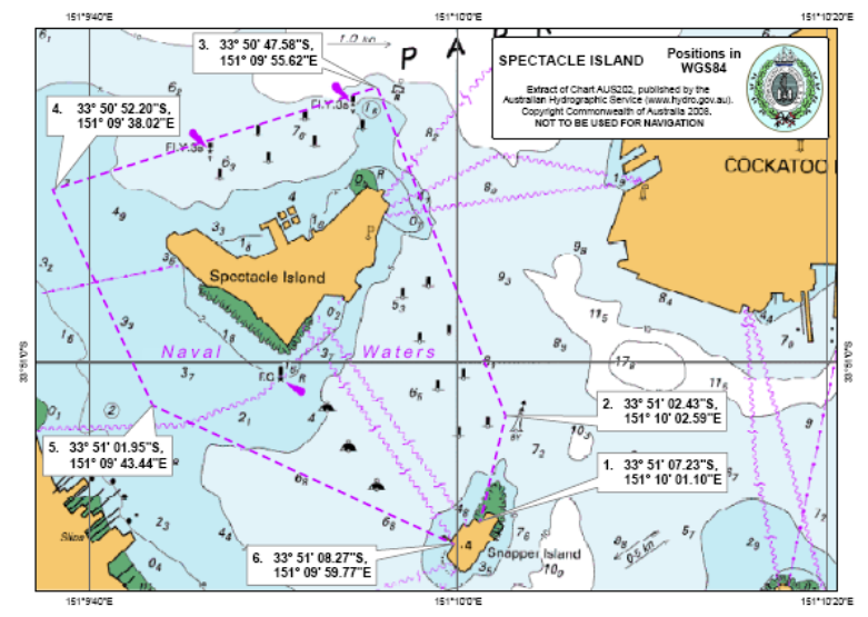
1 | Spectacle Island | All those waters within an area commencing at a point on the HWL nearest to Point 1. Point 1 33 51’ 07.23”S, 151 10’ 01.10”E Point 2 33 51’ 02.43”S, 151 10’ 02.59”E Point 3 33 50’ 47.58”S, 151 09’ 55.62”E Point 4 33 50’ 52.20”S, 151 09’ 38.02”E Point 5 33 51’ 01.95”S, 151 09’ 43.44”E Then to a point on the HWL nearest to Point 6. Point 6 33 51’ 08.27”S, 151 09’ 59.77”E Then generally north along the HWL to a point on the HWL nearest to Point 1. | Spectacle Island |
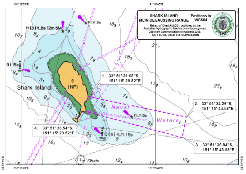
2 | Shark Island MC/N Degaussing Range | All those waters within an area commencing at a point on the HWL nearest to Point 1. Point 1 33 51’ 31.68”S, 151 15’ 29.82”E Point 2 33 51’ 34.26”S, 151 15’ 44.58”E Point 3 33 51’ 36.84”S, 151 15’ 43.98”E Then to a point on the HWL nearest to Point 4. Point 4 33 51’ 33.54”S, 151 15’ 29.52”E Then generally north along the HWL to a point on the HWL nearest to Point 1. | Shark Island MC/N Degaussing Range |
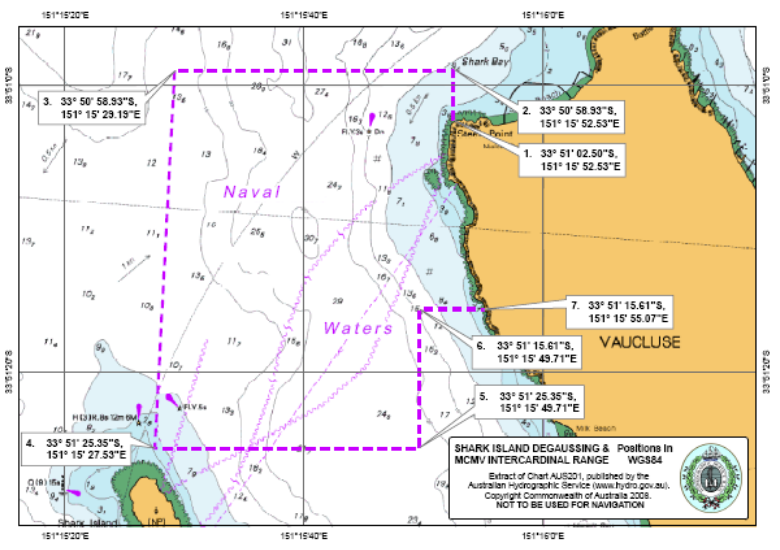
3 | Shark Island Degaussing & Mine Counter Measures Vessels Intercardinal Range | All those waters within an area commencing at a point on the HWL on the northern side of Steele Point, Vaucluse nearest to Point 1. Point 1 33 51’ 02.50”S, 151 15’ 52.53”E Point 2 33 50’ 58.93’S, 151 15’ 52.53”E Point 3 33 50’ 58.93”S, 151 15’ 29.19”E Point 4 33 51’ 25.35”S, 151 15’ 27.53”E Point 5 33 51’ 25.35”S, 151 15’ 49.71”E Point 6 33 51’ 15.61”S, 151 15’ 49.71”E then directly to a point on the HWL nearest to Point 7 Point 7 33 51’ 15.61”S, 151 15’ 55.07”E Then generally north along the HWL to a point on the HWL nearest to Point 1.
| Shark Island Degaussing & MCMV Intercardinal Range |
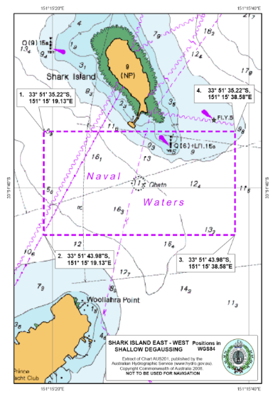
4 | Shark Island East-West Shallow Degaussing | All those waters within the area commencing at Point 1. Point 1 33 51’ 35.22”S, 151 15’ 19.13”E Point 2 33 51’ 43.98”S, 151 15’ 19.13”E Point 3 33 51’ 43.98”S, 151 15’ 38.58”E Point 4 33 51’ 35.22”S, 151 15’ 38.58”E Then along bearing 270 to Point 1. | Shark Island East - West Shallow Degaussing |
5 | Eden Ammunition Wharf, Twofold Bay | All those waters within an area commencing at a point on the HWL on the western shore of Munganno Point nearest to Point 1. Point 1 37 06’ 10.80”S, 149 55’ 42.00”E Point 2 37 06’ 05.70”S, 149 55’ 12.90”E then directly to a point on the HWL nearest to Point 3 Point 3 37 06’ 37.20”S, 149 55’ 05.10”E Then generally west and north along the HWL of East Boyd Bay to a point on the HWL nearest to Point 1. | Eden Ammunition Wharf |
6 | Rushcutters Bay Moorings & Wharves | All those waters within an area commencing at a point on the HWL on the Eastern shore of Rushcutters Bay nearest to Point 1. Point 1 33 52’ 23.34”S, 151 14’ 04.02”E Point 2 33 52’ 21.73”S, 151 14’ 01.58”E Point 3 33 52’ 21.37”S, 151 14’ 01.92”E Point 4 33 52’ 16.03”S, 151 13’ 55.29”E Point 5 33 52’ 13.18”S, 151 13’ 58.59”E Then directly to a point on the HWL nearest to Point 6 Point 6 33 52’ 19.46”S, 151 14’ 06.39”E Then generally south along the HWL to a point on the HWL nearest to Point 1. | Rushcutters Bay |
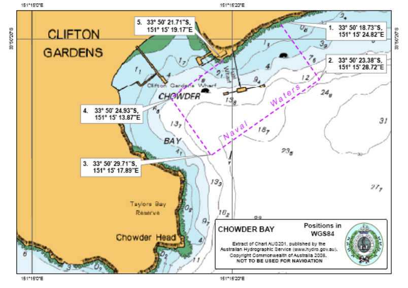
7 | Chowder Bay Naval Fuel Installation | All those waters within an area commencing at a point on the HWL on the northern shore of Chowder Bay nearest to Point 1. Point 1 33 50’ 18.73”S, 151 15’ 24.82”E Point 2 33 50’ 23.38”S, 151 15’ 28.72”E Point 3 33 50’ 29.71”S, 151 15’ 17.89”E Point 4 33 50’ 24.93”S, 151 15’ 13.87”E Then directly to a point on the HWL nearest to Point 5 Point 5 33 50’ 21.71”S, 151 15’ 19.17”E Then generally north-east along the HWL to a point on the HWL nearest to Point 1. | Chowder Bay |
|
|
|
|
8 | HMAS PENGUIN | All those waters within an area commencing at a point on the HWL on the southern shore of Hunters Bay nearest to Point 1. Point 1 33 49’ 35.72”S, 151 15’ 24.10”E Point 2 33 49’ 32.15”S, 151 15’ 24.10”E Point 3 33 49’ 28.59”S, 151 15’ 28.07”E Point 4 33 49’ 26.15”S, 151 15’ 34.65”E Point 5 33 49’ 30.33”S, 151 15’ 36.77”E Then directly to a point on the HWL nearest to Point 6 Point 6 33 49’ 28.25”S, 151 15’ 48.90”E Then generally south and west along the HWL to a point on the HWL nearest to Point 1. | HMAS PENGUIN |
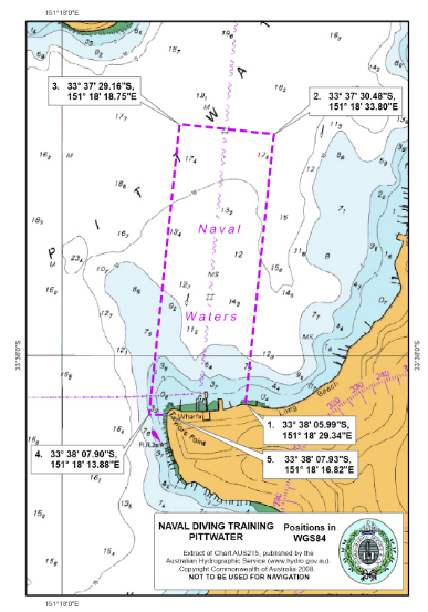
9 | Naval Diving Training Area, Pittwater | All those waters within an area commencing at a point on the HWL nearest to Point 1. Point 1 33 38’ 05.99”S, 151 18’ 29.34”E Point 2 33 37’ 30.48”S, 151 18’ 33.80”E Point 3 33 37’ 29.16”S, 151 18’ 18.75”E Point 4 33 38’ 07.90”S, 151 18’ 13.88”E Then directly to a point on the HWL nearest to Point 5 Point 5 33 38’ 07.93”S, 151 18’ 16.82”E Then generally east along the HWL to a point on the HWL nearest to Point 1. | Naval Diving Training Pittwater |
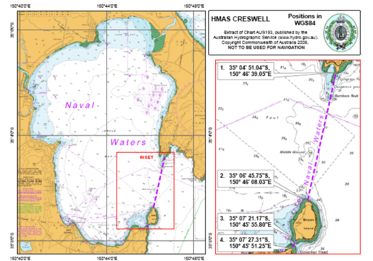
10 | HMAS CRESWELL and Naval Anchorages & Ranges, Jervis Bay | All those waters within Jervis Bay west of a boundary line commencing at a point on the HWL on the most southerly point of Longnose Point nearest to Point 1. Point 1 35 04’ 51.04”S, 150 46’ 39.05”E Then directly to a point on the HWL on the most northerly point of Bowen Island nearest to Point 2. Point 2 35 06’ 45.75”S, 150 46’ 08.03”E Then generally south along the HWL of Bowen Island to a point on the HWL nearest to Point 3 Point 3 35 07’ 21.17”S, 150 45’ 55.80”E Then directly to and finishing at a point on the HWL on the most northerly point of Governor Head nearest to Point 4. Point 4 35 07’ 27.31”S, 150 45’ 51.25”E | HMAS CRESWELL |
|
|
|
|
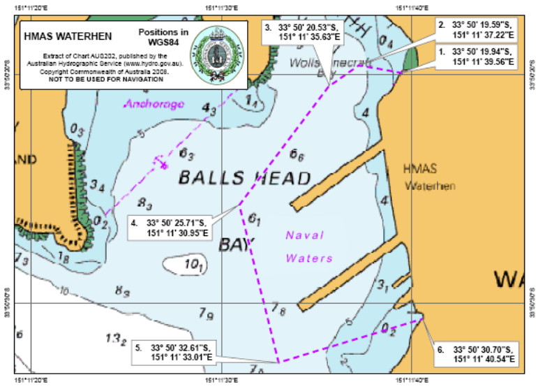
11 | HMAS WATERHEN | All those waters within an area commencing at a point on the HWL on the eastern shore of Balls Head Bay nearest to Point 1. Point 1 33 50’ 19.94”S, 151 11’ 39.56”E Point 2 33 50’ 19.59”S, 151 11’ 37.22”E Point 3 33 50’ 20.53”S, 151 11’ 35.63”E Point 4 33 50’ 25.71”S, 151 11’ 30.95”E Point 5 33 50’ 32.61”S, 151 11’ 33.01”E Then directly to a point on the HWL nearest to Point 6 Point 6 33 50’ 30.70”S, 151 11’ 40.54”E Then generally north along the HWL to a point on the HWL nearest to Point 1. | HMAS WATERHEN |
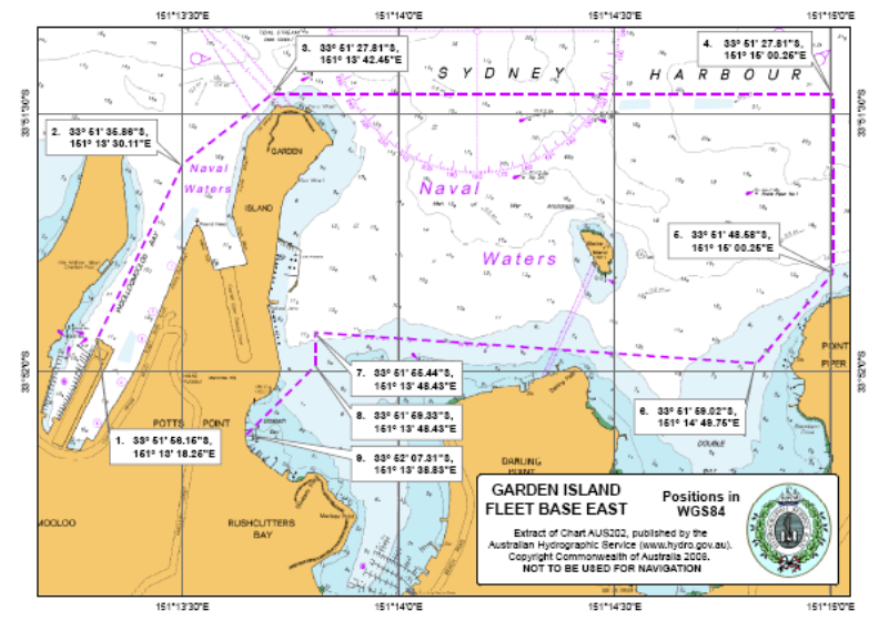
12 | Garden Island Fleet Base East | All those waters within an area commencing at a point on the western face of Woolloomooloo Bay finger wharf (Point 1). Point 1 33 51’ 56.15”S, 151 13’ 18.25”E Point 2 33 51’ 35.86”S, 151 13’ 30.11”E Point 3 33 51’ 27.81”S, 151 13’ 42.45”E Point 4 33 51’ 27.81”S, 151 15’ 00.25”E Point 5 33 51’ 48.58”S, 151 15’ 00.25”E Point 6 33 51’ 59.02”S, 151 14’ 49.75”E Point 7 33 51’ 55.44”S, 151 13’ 48.43”E Point 8 33 51’ 59.33”S, 151 13’ 48.43”E Then directly to a point on the HWL nearest to Point 9 Point 9 33 52’ 07.31”S, 151 13’ 38.83”E Then generally north along the HWL to a point on the HWL nearest to Point 1. | Garden Island Fleet Base East |
Schedule 2 Declaration of naval waters —
Victoria
1 Item | 2 Installation or defence land | 3 Waters For the purpose of this description the term high water line (HWL) means the Mean Higher High Water as defined in the Australian Hydrographic Service Tidal Glossary | 4 Chart or map title |
1 | HMAS CERBERUS | All the waters within an area commencing at a point on the HWL of Stony Point nearest to Point 1. Point 1 38 22’ 29.48”S, 145 13’ 19.115”E Point 2 38 22’ 29.48”S, 145 15’ 58.11”E Point 3 38 24’ 42.00”S, 145 15’ 58.11”E Point 4 38 24’ 42.00”S, 145 12’ 12.00”E Then directly to a point on the HWL nearest to Point 5. Point 5 38 24’ 17.20”S, 145 12’ 12.00”E Then generally east and north along the HWL of Hanns Inlet to a point on the HWL nearest to Point 1. | HMAS CERBERUS |
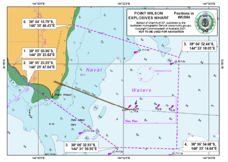
2 | Point Wilson Explosives Wharf | All the waters within an area commencing at a point on the HWL of Point Wilson nearest to Point 1. Point 1 38 05’ 03.06”S, 144 29’ 23.82”E Point 2 38 05’ 23.25”S, 144 29’ 47.04”E Point 3 38 06’ 32.93”S, 144 31’ 50.90”E Point 4 38 06’ 34.68”S, 144 33’ 14.64”E Point 5 38 04’ 52.44”S, 144 33’ 18.05”E Then directly to a point on the HWL nearest to Point 6. Point 6 38 04’ 15.79”S, 144 30’ 48.43”E Then generally south and west along the HWL to a point on the HWL nearest to Point 1. | Point Wilson Explosives Wharf |
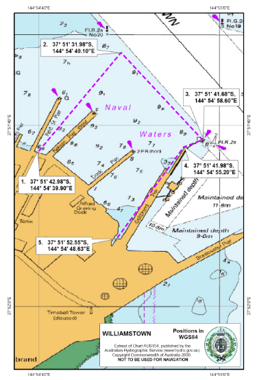
3 | Williamstown Dockyard, Hobson’s Bay | All the waters within an area commencing at a point on the HWL of Hobson’s Bay nearest to Point 1. Point 1 37 51’ 42.98”S, 144 54’ 39.90”E Point 2 37 51’ 31.98”S, 144 54’ 49.10”E Point 3 37 51’ 41.68”S, 144 54’ 58.60”E Point 4 37 51’ 41.98”S, 144 54’ 55.20”E Then generally south-westerly along the pier to a point on the HWL nearest to Point 5. Point 5 37 51’ 52.55”S, 144 54’ 48.63”E Then generally north-westerly along the HWL to a point on the HWL nearest to Point 1. | Williamstown |
|
|
|
|
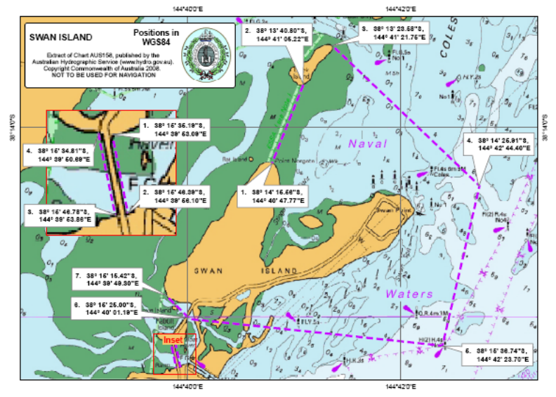
4 | Swan Island | Main Area All the waters within an area commencing at a point on the HWL on the most northerly point of Swan Island nearest to Point 1. Point 1 38° 14’ 15.56”S, 144° 40’ 47.77”E Then directly to a point on the HWL on the most southern point of Duck Island nearest to Point 2. Point 2 38° 13’ 40.80”S, 144° 41’ 05.22”E Then generally east and north along the HWL to a point on the HWL nearest to Point 3. Point 3 38° 13’ 23.58”S, 144° 41’ 21.75”E Point 4 38° 14’ 25.91”S, 144° 42’ 44.40”E Point 5 38° 15’ 36.74”S, 144° 42’ 23.70”E Point 6 38° 15’ 25.00”S, 144° 40’ 01.19”E Then directly to a point on the HWL on Swan Island nearest to point 7. Point 7 38° 15’ 15.42”S, 144° 39’ 49.30”E The generally north-easterly along the HWL to a point on the HWL nearest to Point 1. Access Area All those waters within an area commencing at a point at the HWL on the south eastern shore of Langerby Island (also known as Rabbit Island) nearest to Point 1. Point 1 38° 15’ 35.19”S, 144° 39’ 53.09”E Then directly to a point on the HWL on the northern shore of Queenscliff nearest to Point 2. Point 2 38° 15’ 46.39”S, 144° 39’ 56.10”E Then generally westerly to a point on the HWL nearest to Point 3. Point 3 38° 15’ 46.78”S, 144° 39’ 53.86”E Then directly to a point on the HWL on the southern shore of Langerby Island (also known as Rabbit Island) nearest to Point 4. Point 4 38° 15’ 34.81”S, 144° 39’ 50.69”E Then generally east along the HWL to a point on the HWL nearest to Point 1. | Swan Island |
Schedule 3 Declaration of naval waters — Western Australia
1 Item | 2 Installation or defence land | 3 Waters For the purpose of this description the term high water line (HWL) means the Mean Higher High Water as defined in the Australian Hydrographic Service Tidal Glossary | 4 Chart or map title |
1 | Point Murat Wharf, Exmouth | All those waters within an area commencing at a point on the HWL nearest to Point 1. Point 1 21 48’ 47.77”S, 114 11’ 24.64”E Point 2 21 48’ 54.32”S, 114 11’ 57.45”E Point 3 21 49’ 17.49”S, 114 11’ 51.70”E Point 4 21 49’ 09.66”S, 114 11’ 15.54”E Then directly to a point on the HWL nearest to Point 5. Point 5 21 49’ 04.06”S, 114 11’ 16.89”E Then generally north along the HWL to a point on the HWL nearest to Point 1. | Point Murat |
2 | HMAS STIRLING | Garden Island All those waters within the area of Cockburn Sound commencing at a point on the HWL nearest to Point 1. Point 1 32 16’ 06.43”S, 115 41’ 56.35”E Point 2 32 16’ 05.83”S, 115 41’ 51.54”E Point 3 32 15’ 06.53”S, 115 42’ 10.17”E Point 4 32 14’ 49.03”S, 115 41’ 58.75”E Point 5 32 15’ 05.33”S, 115 40’ 31.17”E Point 6 32 09’ 06.53”S, 115 38’ 53.36”E Point 7 32 09’ 06.53”S, 115 40’ 27.56”E Point 8 32 09’ 51.45”S, 115 40’ 47.97”E Point 9 32 11’ 06.17”S, 115 41’ 21.96”E Point 10 32 13’ 58.03”S, 115 42’ 40.13”E Point 11 32 14’ 41.22”S, 115 42’ 09.56”E Point 12 32 15’ 04.73”S, 115 42’ 25.17”E Point 13 32 16’ 07.73”S, 115 42’ 05.37”E Point 14 32 16’ 06.41”S, 115 42’ 00.55”E Then generally west to a point on the HWL nearest to Point 1. Armament Jetty All those waters in the vicinity of the Armament Jetty in Sulphur Bay defined as a circle of radius 1300 metres centred on position 32 10’ 33.60”S, 115 40’ 50.40”E.
| HMAS STIRLING FLEET BASE WEST |
3 | Dampier Naval Buoy | All those waters in the vicinity of the naval buoy in Dampier Harbour defined as a circle of 182.88 metres radius centred on the buoy nearest the position 20 37’ 19.30”S, 116 44’ 18.60”E. | Dampier |
Schedule 4 Declaration of naval waters — Queensland
Item | Installation or defence land | Waters For the purpose of this description the term high water line (HWL) means the Mean Higher High Water as defined in the Australian Hydrographic Service Tidal Glossary | Chart or map title
|
1 | HMAS CAIRNS | All those waters within an area commencing at a point on the HWL nearest to Point 1. Point 1 16 56’ 05.45”S, 145 46’ 41.21”E Point 2 16 56’ 06.44”S, 145 46’ 44.94”E Point 3 16 56’ 06.40”S, 145 46’ 46.20”E Point 4 16 56’ 20.83”S, 145 46’ 48.22”E Point 5 16 56’ 20.97”S, 145 46’ 46.33”E Point 6 16 56’ 17.38”S, 145 46’ 45.94”E Then directly to a point on the HWL nearest to Point 7 Point 7 16 56’ 16.60”S, 145 46’ 42.91”E Then generally north along the HWL to a point on the HWL nearest to Point 1. | HMAS CAIRNS |
Schedule 5 Declaration of naval waters — Northern Territory
Item | Installation or defence land | Waters For the purpose of this description the term high water line (HWL) means the Mean Higher High Water as defined in the Australian Hydrographic Service Tidal Glossary | Chart or map title
|
1 | HMAS COONAWARRA | All those waters within an area commencing at a point on the HWL nearest to Point 1. Point 1 12 27’ 38.01”S, 130 49’ 41.14”E Point 2 12 27’ 54.90”S, 130 49’ 41.14”E Point 3 12 27’ 54.90”S, 130 49’ 03.46”E Then directly to a point on the HWL on Elliot Point nearest to Point 4. Point 4 12 27’ 29.90”S, 130 49’ 03.46”E Then generally east along the HWL to a point on the HWL nearest to Point 1. | HMAS COONAWARRA |
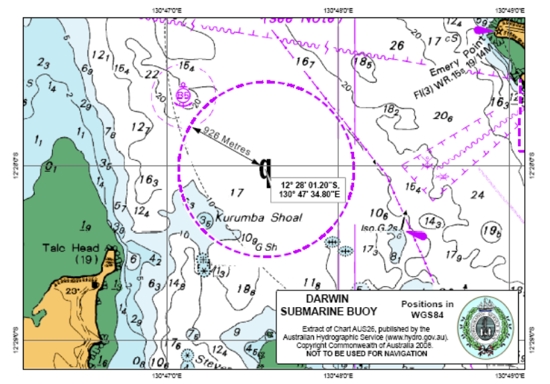
2 | Darwin Submarine Buoy | All those waters in the vicinity of the submarine buoy in Darwin Harbour defined as a circle of 926 metres radius centred on the buoy nearest the position 12 28’ 01.20”S, 130 47’ 34.80”E. | Darwin Submarine Buoy |