
Macquarie Island Marine Park
Management Plan
This plan may be cited as:
© Commonwealth of Australia. 2001.
Macquarie Island Marine Park Management Plan.
Environment Australia, Canberra.
This work is copyright. Apart from any use as permitted under the Copyright Act 1968, no part may be reproduced by any process without prior written permission from Environment Australia. Requests and enquiries concerning reproduction and rights should be addressed to the First Assistant Secretary, Marine and Water Division – Environment Australia, GPO Box 787, CANBERRA ACT 2601.
Cover images
LINE DRAWING:
Patagonian toothfish, Dissostychus eleginoides.
Drawing: courtesy of the Food and Agriculture Organisation of the United Nations and the Commission for the Conservation of Antarctic Marine Living Resources
Source: FAO Species Identification Sheets for Fishery Purposes.
FOUR SMALL IMAGES - LEFT TO RIGHT:
Preparing a plankton sampling net for deployment, on the CSIRO FRV "Southern Surveyor".
Photo courtesy Karen Gowlett-Holmes, CSIRO Marine Research
© Commonwealth of Australia
Elephant seals.
Australian Antarctic Division, photo by Rowan Butler
© Commonwealth of Australia
A king crab, Lithodes murrayi, collected during a research cruise on the CSIRO FRV Southern Surveyor off Macquarie Island in January 1999.
Photo courtesy Karen Gowlett-Holmes, CSIRO Marine Research
© Commonwealth of Australia
Royal penguins.
Australian Antarctic Division, photo by Christo Baarss
© Commonwealth of Australia
LARGE BLACK & WHITE IMAGE:
Wandering albatross.
Australian Antarctic Division, photo by Christo Baarss
© Commonwealth of Australia
Internal image
SECTION HEADINGS:
Penguin rookery.
Australian Antarctic Division, photo by Christo Baarss
© Commonwealth of Australia
The Macquarie Island Marine Park was proclaimed under the National Parks and Wildlife Conservation Act 1975 (NPWC Act) on 27 October 1999. The Marine Park was proclaimed to protect the unique and vulnerable marine ecosystems of the south-eastern portion of the Commonwealth waters around Macquarie Island. It adjoins the Macquarie Island Nature Reserve declared under the National Parks and Wildlife Act 1970 (Tas.) in 1978. A marine extension to the Nature Reserve was gazetted on 2 August 2000. The Macquarie Island Marine Park includes significant feeding and migratory areas for a number of threatened marine mammals and seabirds, a variety of benthic habitats spanning a wide range of depths and oceanic conditions, and seabed sediments down to 100 metres below the seafloor. Environment Australia is the Commonwealth Government’s managing authority for the Marine Park.
Macquarie Island Marine Park is part of the National Representative System of Marine Protected Areas (NRSMPA). The primary goal of the NRSMPA is to establish and manage a comprehensive, adequate and representative system of marine protected areas to contribute to the long-term ecological viability of marine and estuarine systems, to maintain ecological processes and systems, and to protect Australia’s biological diversity at all levels. Marine protected areas within the NRSMPA have been established especially for the conservation of biological diversity and have a secure status. In December 1998, the Commonwealth Government launched Australia’s Oceans Policy (Commonwealth of Australia, 1998) with a commitment to integrated and ecosystem-based planning and management. The Oceans Policy has the delivery of the NRSMPA as a major focus.
The preparation of this Management Plan was carried out in accordance with the Environment Protection and Biodiversity Conservation Act 1999 (EPBC Act), which replaced the NPWC Act on 16 July 2000, and provides for the protection and conservation of the Macquarie Island Marine Park. The Environment Protection and Biodiversity Conservation Regulations 2000 (EPBC Regulations) made under the EPBC Act will apply, in accordance with this Plan.
The Plan sets out strategic objectives, management goals and management strategies to ensure that the natural, social and other values of the area receive an appropriate level of protection. As required by the EPBC Act, the Plan assigns an IUCN (World Conservation Union) Protected Area Management Category to the Marine Park and to each of its zones. It indicates the activities that may be carried on and those that are to be prohibited or regulated in the Marine Park. As far as possible, the management goals and strategies will be consistent with the management regime developed by the Tasmanian Government for the marine zone of the Macquarie Island Nature Reserve.
The management planning for the Marine Park is designed to conform to Best Practice in Performance Reporting in Natural Resource Management (Australian and New Zealand Environment and Conservation Council (ANZECC), 1997) with an emphasis on goals, strategies, performance measures, targets and monitoring. The performance assessment framework will also generally follow the Strategic Plan of Action for the National Representative System of Marine Protected Areas: A Guide for Action by Australian Governments (ANZECC Task Force on Marine Protected Areas (TFMPA), 1999).
As required under the EPBC Act, the Plan will cease to have effect seven years after a notice of its operation has been published in the Commonwealth Gazette. The Plan itself may only be altered following the same statutory process and consultative processes used in its preparation.
Conall O’Connell
First Assistant Secretary
Marine and Water Division
Environment Australia
GPO Box 787
Canberra ACT 2601
Environment Australia is grateful to those individuals and organisations that assisted in the drafting of this Management Plan. The contribution of those individuals and groups that provided initial comments, information and assistance in the period leading up to the proclamation of the Marine Park is also acknowledged. In February 2001 the draft Plan was released for public comment. The submissions received were incorporated into the Plan where appropriate, and Environment Australia also gratefully acknowledges the input from these submissions.
Foreword
Acknowledgments
Contents
Abbreviations of frequently used terms
Glossary
Summary
1. Introduction
Figure 1 Location of the Macquarie Island Marine Park
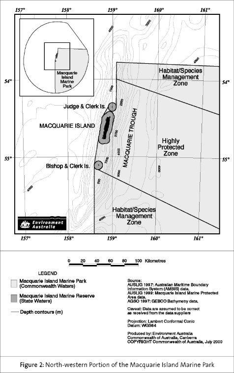
Figure 2 North-western Portion of the Macquarie Island Marine Park
2. Management Framework
2.1 National and International Context
2.2 Legislative Context
2.3 Ecosystem-based Management
3. Strategic Objectives
4. Description of the Macquarie Island Region and the Macquarie Island Marine Park
4.1 The Macquarie Island Region
4.1.1 National and International Conservation Significance
Figure 3 Major Oceanic Fronts in the Macquarie Island Region
TABLE 1
Threatened Species of the Macquarie Island Region
4.1.2 Conservation Values across the Region
4.1.3 Social and Economic Values of the Region
4.2 The Macquarie Island Marine Park
4.2.1 Conservation Values in the Marine Park
5. Pressures on the Conservation Values of the Macquarie Island Marine Park
5.1 Commercial Fishing
5.1.1 Trawling
5.1.2 Longlining
5.2 Research
5.3 Tourism
5.4 Mineral or Petroleum Exploration and Extraction
5.5 Shipping
TABLE 2
Summary of Existing and Potential Pressures on Conservation Values
6. Managing the Macquarie Island Marine Park
6.1 IUCN Protected Area Management Categories
6.2 Management of the Highly Protected Zone
6.2.1 Management Goals
6.2.2 Management Strategies
6.3 Management of the Habitat/Species Management Zones
6.3.1 Management Goals
6.3.2 Management Strategies
6.4 Scientific Research and Monitoring
6.4.1 Management Goals
6.4.2 Management Strategies
7. Reviewing this Plan
7.1 Performance Assessment
7.2 Reviewing the Management Plan
8. Bibliography
Attachment 1: Proclamation of the Macquarie Island Marine Park
Attachment 2: Australian IUCN Reserve Management Principles Applying to the Macquarie Island Marine Park
Attachment 3: Principles of Ecologically Sustainable Development as defined in the Environment Protection and Biodiversity Conservation Act 1999 - section 3A.
Attachment 4: Seabirds of the Macquarie Island Region
Attachment 5: Marine Mammals of the Macquarie Island Region
Tables
1 Threatened Species of the Macquarie Island Region 19
2 Summary of Existing and Potential Pressures on Conservation Values 33
Figures
1 Location of the Macquarie Island Marine Park 7
2 North-western Portion of the Macquarie Island Marine Park 8
3 Major Oceanic Fronts in the Macquarie Island Region 18
AAD | Australian Antarctic Division |
AFMA | Australian Fisheries Management Authority |
AGSO | Australian Geological Survey Organisation |
ANZECC | Australian and New Zealand Environment and Conservation Council |
CCAMLR | Convention on the Conservation of Antarctic Marine Living Resources |
CSIRO | Commonwealth Scientific and Industrial Research Organisation |
Director | Director of National Parks |
DPIWE | Department of Primary Industries, Water and Environment (Tasmania) |
DPWH | Department of Parks, Wildlife and Heritage (Tasmania - now part of DPIWE) |
EEZ | Australian Exclusive Economic Zone |
EPBC Act | Environment Protection and Biodiversity Conservation Act 1999 |
EPBC Regulations | |
FRDC | Fisheries Research and Development Corporation |
IMCRA | Interim Marine and Coastal Regionalisation for Australia |
IUCN | World Conservation Union (previously International Union for the Conservation of Nature and Natural Resources) |
NPWC Act | National Parks and Wildlife Conservation Act 1975 |
NRSMPA | National Representative System of Marine Protected Areas |
TFMPA | Task Force on Marine Protected Areas |
UNCLOS | United Nations Convention on the Law of the Sea |
UNESCO | United Nations Educational, Scientific and Cultural Organization |
Benthic/benthos: Refers to marine organisms that live on, in or near the ocean floor.
Biogeographic: Relates to large regions with distinct landscapes or seascapes, plants and animals.
Biological diversity: The variability among living organisms and the ecological complexes of which they are part; this includes the diversity within and between species and of ecosystems.
By-catch: Non-target species taken incidentally during fishing activities.
Conservation: The maintenance of conditions or features in a sound or unimpaired state.
Conservation dependent: Refers to a native species that is subject to a specific conservation program to prevent it from becoming threatened with extinction.
Demersal: Refers to species or activities that are closely associated with the ocean floor.
Ecosystem: A dynamic complex of plant, animal and micro-organism communities and their non-living environment interacting as a functional unit.
Endemic: Refers to organisms whose distribution is restricted to a particular locality.
Exotic species: Organisms that are not native to an area.
Flotsam and jetsam: Natural and artificial matter floating on the open sea.
Geomorphology/geomorphic: Relates to the structure and development of the Earth's physical surface.
IUCN Red List: Catalogue devised by the IUCN (World Conservation Union) that identifies those species at risk of global extinction.
Long-lining: Fishing method using a mainline with many attached branch lines, each fitted with one or more baited hooks or artificial lures.
Mitigation measures: Refers to actions to reduce environmental impacts of specific human activities.
Pelagic: Refers to species or activities that normally live or occur near the sea surface or in the water column.
Precautionary management: Refers to measures taken to prevent environmental degradation whilst further information is obtained on environmental conditions, threats and impacts.
Seismic surveys/sounds: Refers to the study of the profile and composition of the sea floor through emission and reflection of artificial energy waves.
Spatial and temporal distribution: Refers to spread over space and/or time.
Threatened species/community: Refers to a native species or ecological community that is listed under legislation or IUCN criteria as being at varying degrees of risk of extinction in the future.
Threatening process: Activities that threaten or may threaten the survival, abundance or evolutionary development of a native species or ecological community.
Trawling: Fishing using a weighted net usually dragged along the sea floor, often with bobbins or discs to assist its passage over the sea floor.
Trophic: Relates to position of organisms in the food chain of an ecosystem based on type of food supply required.
1. Introduction
The Macquarie Island Marine Park is located approximately 1500 kilometres south-south-east of Tasmania and makes up around one-third (~16.2 million hectares) of the Exclusive Economic Zone around Macquarie Island and its associated islets. The Marine Park was proclaimed on 27 October 1999 and will be managed by the Commonwealth Government under the Environment Protection and Biodiversity Conservation Act 1999 (EPBC Act). This is the first Management Plan prepared for the Macquarie Island Marine Park.
2. Management Framework
The Marine Park is part of the National Representative System of Marine Protected Areas (NRSMPA). Delivery of the NRSMPA is a major focus of Australia’s Oceans Policy.
This draft Plan assists in fulfilling Australia’s responsibilities under the 1982 United Nations Convention on the Law of the Sea (UNCLOS). The establishment of the Marine Park assists Australia in meeting its obligations under the Convention on Biological Diversity, the World Heritage Convention, the Convention on the Conservation of Migratory Species of Wild Animals (Bonn Convention) and the International Convention for the Regulation of Whaling. The Marine Park lies just outside the area covered by the Convention on the Conservation of Antarctic Marine Living Resources (CCAMLR). However, Australia must harmonise with CCAMLR measures, with any conservation measures for harvesting in areas adjacent to the area covered by CCAMLR, and must also ensure any harvesting is conducted in a responsible manner.
Under the EPBC Act, administration, management and control of Commonwealth reserves is the responsibility of the Director of National Parks. The Director’s functions and powers in relation to the Marine Park have been delegated to the First Assistant Secretary, Marine and Water Division, Environment Australia.
3. Strategic Objectives
The strategic objectives for the Marine Park are as follows:
- To protect the conservation values of the south-eastern portion of the Macquarie Island Region including protecting:
- the migratory, feeding and breeding ranges of marine mammals and seabirds;
- threatened species that depend on the area; and
- the unique benthic habitat.
- To provide an effective conservation framework which will contribute to the integrated and ecologically sustainable use and management of the Macquarie Island Region.
- To provide a scientific reference area for the study of ecosystem function within the Macquarie Island Region.
- To manage the area as part of the National Representative System of Marine Protected Areas.
4. Description of the Macquarie Island Region and the Macquarie Island Marine Park
The Macquarie Island Region contains important habitat for five species of seals and 38 species of seabird, during various life stages. A number of these species are under local or global threat according to Commonwealth/State legislation and/or IUCN Red List criteria. The Macquarie Island Marine Park contributes to the only ‘biosphere reserve’ in the Southern Ocean, one of 12 in Australia. Biosphere reserves are part of the Man and the Biosphere Program of the United Nations Educational, Scientific and Cultural Organization (UNESCO).
The Macquarie Ridge, located largely within the Marine Park, is one of the world’s great oceanic ridges, and not only forms a major transform plate boundary, but is probably a relict mid-ocean spreading centre. Macquarie Island and its associated islets were listed in the Register of the National Estate in 1980. The Island and waters out to 12 nautical miles were inscribed on the World Heritage List in 1997.
Macquarie Island is one of few terrestrial habitats in the Pacific sector of the Southern Ocean for marine mammals and seabirds which require land for breeding and moulting. The marine habitats are little known but available data on substrata and oceanography suggests that there are several distinct large-scale habitats. Benthic survey data indicates that the Region is a transition zone, with many species being at the southern or northern limit of their range.
A trawl fishery for Patagonian toothfish has operated in the Region since 1994, initially under exploratory fishing arrangements that have now progressed to a formally managed fishery. The Region is considered to be of global significance for science and education due to its geology and biogeographic characteristics. Tourism to the Island is a small but developing industry. There is no current interest in the Region for purposes of mineral or petroleum exploration or extraction.
5. Pressures on the Conservation Values of the Macquarie Island Marine Park
The existing or potential human activities that could affect the natural and social values of the Marine Park are:
- commercial fishing;
- research;
- tourism;
- mineral or petroleum exploration and extraction; and
- shipping.
6. Managing the Macquarie Island Marine Park
Consistent with the strategic objectives for the Macquarie Island Marine Park, the Marine Park is assigned by the Plan to the IUCN Protected Area Management Category of habitat/species management area (category IV). The Plan divides the Marine Park into three zones: a Highly Protected Zone (assigned to IUCN category Ia) and two Habitat/Species Management Zones (IUCN category IV) either side of the Highly Protected Zone. The provisions of the Plan are consistent with the Australian Reserve Management Principles for the IUCN categories to which the Marine Park and zones are assigned by the Plan.
In summary, the main management goals and management strategies in the Highly Protected Zone are:
Management goals:
- Provide a scientific reference area for further studies of natural ecosystems, including baseline areas.
- Protect threatened species and migratory and foraging marine mammals and seabirds from direct human disturbance.
- Protect pelagic species and the benthic communities from direct human disturbance.
Management strategies:
- No commercial or recreational fishing will be allowed.
- No mining operations, including petroleum and/or mineral exploration or extraction, will be allowed.
- No commercial tourism activities will be allowed.
- Passive transit of vessels through the zone will be allowed.
- Non-intrusive scientific research compatible with the strategic objectives of the Marine Park and management goals for this zone will be allowed.
- In accordance with the EPBC Regulations, the dumping of waste or littering in the Marine Park is prohibited.
In summary, the main management goals and management strategies in the Habitat/Species Management Zones are:
Management goals:
- Minimise human impacts on the habitats of threatened species, migratory and foraging marine mammals and seabirds, and benthic and pelagic fauna that depend on the area.
- Promote scientific research and environmental monitoring as primary activities associated with sustainable resource management and use.
Management strategies:
- No mining operations, including petroleum and/or mineral exploration or extraction, will be allowed.
- Commercial fishing in accordance with a fishing concession granted by AFMA will be allowed in the Marine Park, subject to determinations or permits made by the Director under EPBC Regulations.
- Limited commercial tourism will be allowed under a permit issued by the Director under the EPBC Regulations.
- Scientific research that is compatible with the strategic objectives of the Marine Park and management goals for this zone will be allowed.
- In accordance with the EPBC Regulations, the dumping of waste or littering in the Marine Park is prohibited.
Additional management goals and management strategies relate specifically to scientific research and monitoring in the Marine Park.
7. Reviewing this Plan
This Plan contains the general foundation of a performance assessment system, including strategic objectives, management goals and management strategies. The detailed performance measures, monitoring programs and targets will be developed separate to this Plan.
Results from the ongoing performance assessment will be used to undertake a review of the Management Plan commencing about two years before the Plan expires. The results of the review will be used in the development of the next Management Plan for the Macquarie Island Marine Park.
Macquarie Island is located in the Southern Ocean approximately 1500 kilometres south-south-east of Tasmania. The Island and its associated islets, Judge and Clerk Islets and Bishop and Clerk Islets, are part of Tasmania. The Tasmanian Government, through the Tasmanian Department of Primary Industries, Water and Environment, is responsible for the management of the terrestrial environment and the surrounding waters out to three nautical miles. The Commonwealth Government is responsible for the management of the area from three nautical miles to the outer edge of the Australian Exclusive Economic Zone (EEZ) around Macquarie Island.
The Macquarie Island Marine Park was proclaimed under the National Parks and Wildlife Conservation Act 1975 (NPWC Act) on 27 October 1999 (see Attachment 1) to protect the unique and vulnerable marine ecosystems of the south-eastern portion of the Macquarie Island Region. The NPWC Act was replaced by the Environment Protection and Biodiversity Conservation Act 1999 (EPBC Act) on 16 July 2000. The proclamation of the Marine Park is continued in force by the Environmental Reform (Consequential Provisions) Act 1999 as if it had been made under the EPBC Act.
The boundaries of the Marine Park are shown in Figures 1 and 2. The Marine Park covers an area of approximately 16.2 million hectares and consists of a central Highly Protected Zone situated between two highly regulated Habitat/Species Management Zones.
Available information on the Macquarie Island Region indicates that it is an area with unique biogeographical characteristics and unusual geological make-up (see Section 4). The Island and surrounding waters out to 12 nautical miles were listed as a World Heritage Area in December 1997 on the basis of these unusual geological features and the aesthetic values of the Island.
As with other islands of the Southern Ocean, Macquarie Island is notable for its overall low biological diversity, but high numbers of some species. The Macquarie Island Region provides habitat for, among others, antarctic and sub-antarctic fur seals, the southern elephant seal, several species of penguins, a number of albatross species, and many benthic and pelagic species. The Region is, however, unusual in its biological composition relative to other areas in the Southern Ocean. A number of its species are threatened according to either the EPBC Act, the Tasmanian Threatened Species Protection Act 1995 or the IUCN Red List criteria.
This is the first Management Plan prepared for the Macquarie Island Marine Park. It has been prepared in consultation with the Tasmanian Department of Primary Industries, Water and Environment and is intended to complement the management plan for the marine zone of the Macquarie Island Nature Reserve.
Consistent with the Macquarie Island Marine Park Proposal (Environment Australia, 1999), the current Marine Park represents those areas of acknowledged high conservation value in the Macquarie Island Region. Consideration of any further areas in the Region for protection and management will occur in the context of establishing the National Representative System of Marine Protected Areas.

Macquarie Island Marine Park is part of the National Representative System of Marine Protected Areas (NRSMPA). The NRSMPA aims to establish and manage a comprehensive, adequate and representative system of marine protected areas, to contribute to the long-term ecological viability of marine systems, to maintain ecological processes and to protect Australia’s biological diversity at all levels (ANZECC TFMPA, 1999). One of the secondary goals of the NRSMPA is to provide for the special needs of threatened species, migratory species and species vulnerable to disturbance. Marine protected areas within the NRSMPA have been established especially for the conservation of biological diversity and have a secure status (i.e., in Australian Commonwealth jurisdiction, they can only be revoked by a proclamation approved by the Commonwealth Parliament).
In December 1998, the Commonwealth Government launched Australia’s Oceans Policy (Commonwealth of Australia, 1998a) with a commitment to integrated and ecosystem-based planning and management. The Oceans Policy has the delivery of the NRSMPA as a major focus. Regional marine plans under the Oceans Policy will contribute to integrating marine protected areas into broader ecosystem management. The first regional marine plan for Australia will be developed for the south-east region, which includes the State and Commonwealth waters around Macquarie Island.
This Plan is consistent with Australia’s obligations under the 1982 United Nations Convention on the Law of the Sea (UNCLOS), which came into force in November 1994. UNCLOS provides a framework to regulate all aspects of the uses of the sea and the conservation of the marine environment.
Establishment and management of the Marine Park assists Australia in meeting its obligations under the 1992 Convention on Biological Diversity. The Convention requires parties to pursue the conservation of biological diversity and the sustainable use of its components. A key feature of the Convention is the establishment of a system of protected areas where special measures need to be taken to conserve biological diversity.
Australia is a State Party to the World Heritage Convention, an international agreement that aims to promote cooperation among nations to protect heritage that is of such outstanding universal value that its conservation is important for current and future generations. The operational guidelines for implementation of the World Heritage Convention include requirements that each World Heritage area should have a management plan and should have adequate long-term legislative protection. The establishment of the Macquarie Island Marine Park and the development of a management plan for this area are consistent with Australia’s World Heritage obligations. The Marine Park covers part of the Commonwealth marine component of the Macquarie Island World Heritage Area. The management prescriptions of this Plan will promote the protection and conservation of the Macquarie Island World Heritage Area and will complement the prescriptions of planning documents for other parts of the World Heritage Area prepared under separate legislation.
The management goals and strategies outlined in this Plan are consistent with Australia’s obligations toward the conservation of migratory species listed on the appendices of the Convention on the Conservation of Migratory Species of Wild Animals (Bonn Convention). Parties to this convention have agreed to protect migratory species and to negotiate and implement agreements for the conservation and management of migratory species with other range states including cooperation and support of research relating to migratory species. Australia has also negotiated bilateral migratory bird agreements with the Governments of Japan and China (Japan-Australia Migratory Bird Agreement (JAMBA), and China-Australia Migratory Bird Agreement (CAMBA), respectively). The management of the Marine Park will help to protect listed migratory species by providing refuge areas where foraging and migration regularly occur.
Australia also has obligations as a member of the International Whaling Commission and a signatory to the International Convention for the Regulation of Whaling. Some of these obligations include providing for the proper conservation of whale stocks through the complete protection of certain species and designation of specified areas as whale sanctuaries, and through promoting relevant research. This Plan contributes to Australia’s fulfilment of these obligations by fully protecting all whales in the Marine Park.
The Marine Park lies just outside the area covered by the Convention on the Conservation of Antarctic Marine Living Resources (CCAMLR). The objective of CCAMLR is the conservation of antarctic marine living resources, where ‘conservation’ includes rational use. CCAMLR requires, among other things, that an ‘ecosystem’ approach be taken to conservation and any harvesting must be managed so as to maintain ecological relationships between harvested, dependent and related species.
The Commission established under CCAMLR, of which Australia is a founding member, has recognised the potential for fish stocks to straddle the CCAMLR boundary and for harvesting in areas adjacent to the convention area to affect conservation outcomes within the convention area. In 1993 the Commission adopted a resolution calling on members with jurisdiction in such adjacent areas to harmonise conservation measures for harvesting in those areas with CCAMLR measures and to ensure any harvesting is conducted in a responsible manner. Macquarie Island is considered to be an ‘adjacent area’. The management measures and objectives adopted for the Patagonian toothfish fishery around Macquarie Island are consistent with, or exceed, the approach CCAMLR takes for similar fisheries in the convention area.
Macquarie Island Marine Park is a Commonwealth reserve under the EPBC Act. Administration, management and control of Commonwealth reserves are functions of the Director of National Parks. The Director’s functions and powers in relation to Macquarie Island Marine Park and other Commonwealth marine reserves have been delegated to the First Assistant Secretary of the Marine and Water Division, Environment Australia.
The EPBC Act requires the Director to prepare management plans for Commonwealth reserves. When prepared, the plans are given to the Minister for the Environment and Heritage for approval. A management plan is a ‘disallowable instrument’ and, following approval by the Minister, must be tabled in each House of the Commonwealth Parliament. A plan may be disallowed by either House of the Parliament.
A management plan for a Commonwealth reserve has effect for up to seven years, subject to being revoked or amended earlier by another management plan for the reserve.
Under the EPBC Act (section 367) a management plan for a Commonwealth reserve must provide for the protection and conservation of the reserve and must assign the reserve to one of the following IUCN Protected Area Management Categories:
- strict nature reserve (IUCN category Ia);
- wilderness area (IUCN category Ib);
- national park (IUCN category II);
- natural monument (IUCN category III);
- habitat/species management area (IUCN category IV);
- protected landscape/seascape (IUCN category V);
- managed resource protected area (IUCN category VI).
The provisions of a management plan for a Commonwealth reserve must not be inconsistent with the Australian IUCN reserve management principles for the IUCN category to which the reserve is assigned by the plan. The management principles are prescribed by Schedule 8 of the EPBC Regulations.
In preparing a management plan, the EPBC Act (section 368) also requires that account be taken of various matters. Matters relevant to the Macquarie Island Marine Park include:
- the regulation of the use of the reserve for the purpose for which it was declared (the preservation of the area in its natural condition; and the encouragement and regulation of the appropriate use, appreciation and enjoyment of the area by the public);
- the interests of any indigenous persons interested in the reserve;
- the protection of the special features of the reserve, including objects and sites of biological, historical, geological and geographical interest;
- the protection, conservation and management of biological diversity and heritage within the reserve;
- the protection of the reserve against damage; and
- Australia's obligations under agreements between Australia and one or more other countries relevant to the protection and conservation of biological diversity and heritage.
The EPBC Act (section 354) prohibits certain acts from being carried on in a Commonwealth reserve except in accordance with a management plan. The acts are:
- kill, injure, take, trade, keep or move a member of a native species;
- damage heritage;
- carry on an excavation;
- erect a building or other structure;
- carry out works; or
- take an action for commercial purposes.
Regulation 12.34 of the EPBC Regulations deals with commercial fishing. It provides for commercial fishing to be carried on in a Commonwealth reserve if authorised by a relevant Commonwealth, State or Territory law (e.g. the Fisheries Management Act 1991 (Cwlth)) or a permit issued under the EPBC Regulations. It also provides for the Director to make determinations affecting the conduct of commercial fishing. A determination may provide that specified kinds of fishing gear cannot be carried or used; specified kinds of fishing gear are required to be carried or used by a person who is fishing or intending to fish; specified practices in commercial fishing are prohibited; and/or specified practices in commercial fishing are to be followed.
The EPBC Act requires the Director to exercise the Director’s powers and perform the Director’s functions to give effect to the management plan for a Commonwealth reserve, and the Commonwealth and other Commonwealth agencies must not perform functions or exercise powers inconsistently with the management plan.
The Macquarie Island Marine Park was proclaimed under the NPWC Act, which was replaced by the EPBC Act on 16 July 2000. The EPBC Act has also replaced four other Commonwealth Acts: the Environment Protection (Impact of Proposals) Act 1974, Endangered Species Protection Act 1992, Whale Protection Act 1980 and World Heritage Properties Conservation Act 1983. These other parts of the EPBC Act will also be relevant to management of Macquarie Island Marine Park and the taking of actions in, and in relation to, the Marine Park.
The taking of an action in a Commonwealth marine area (including the airspace above it) that will have a significant impact on the environment, or the taking of an action outside a Commonwealth marine area that will have a significant impact on the environment in a Commonwealth marine area, will be subject to the assessment and approvals provisions of the EPBC Act. Macquarie Island Marine Park is a ‘Commonwealth marine area’ for the purposes of the EPBC Act.
Actions that would, or are likely to, have a significant impact on a specified matter of ‘national environmental significance’ will also be subject to the assessment and approval provisions of the EPBC Act. The matters of national environmental significance are:
- World Heritage;
- wetlands of international importance (Ramsar wetlands);
- listed threatened species and communities;
- listed migratory species;
- nuclear actions;
- the marine environment; and
- such further actions as are prescribed by the EPBC Regulations under the EPBC Act.
Responsibility for compliance with the assessment and approvals provisions of the EPBC Act lies with persons taking relevant ‘controlled’ actions. A person proposing to take an action that the person thinks may be or is a controlled action must refer the proposal to the Minister for the Environment and Heritage for the Minister’s decision whether or not the action is a controlled action. The EPBC Act also contains provisions that prohibit and regulate actions in relation to threatened species, migratory species, cetaceans (whales and dolphins) and other (listed) marine species. Civil and criminal penalties may be imposed for breaches of the EPBC Act.
Macquarie Island Marine Park is a representative sample of a much larger area used by a number of broad-ranging species. For the approximately 3.5 million seabirds and 100 000 seals which rely on both Macquarie Island and the surrounding waters for certain stages of their lives, this area represents only a small portion of the marine ecosystems of which they are a part. Many of these animals spend long periods of their lives migrating to and from distant areas, where they are susceptible to any number of threats. The Marine Park is limited by Australia’s EEZ and cannot be expected to provide total protection for these animals. Cooperative arrangements for managing species and threats across Commonwealth–State and international boundaries will also be important for their long-term survival. The management strategies outlined below describe some mechanisms for this kind of cooperation within Australian waters and internationally.
The strategic objectives for the Macquarie Island Marine Park are designed to comply with the EPBC Act, the Strategic Plan of Action for the National Representative System of Marine Protected Areas: A Guide for Action by Australian Governments (ANZECC TFMPA, 1999) and the purposes for which the Marine Park was proclaimed. The objectives form the basis for this Plan. They are:
- To protect the conservation values of the south-eastern portion of the Macquarie Island Region including protecting:
- the migratory, feeding and breeding ranges of marine mammals and seabirds;
- threatened species that depend on the area; and
- the unique benthic habitat.
- To provide an effective conservation framework which will contribute to the integrated and ecologically sustainable use and management of the Macquarie Island Region.
- To provide a scientific reference area for the study of ecosystem function within the Macquarie Island Region.
- To manage the area as part of the National Representative System of Marine Protected Areas.
Macquarie Island is located in the Macquarie Island Region of the Southern Ocean in the vicinity of 5430’S, 15855’E (DPWH, 1991). It is the exposed crest of the Macquarie Ridge, a component of the oceanic crust formed in deep water as a spreading ridge and raised as the Indian-Australian tectonic plate interacts with the Pacific plate (Australian Heritage Commission, 2000). Macquarie Island is approximately 34 kilometres long and up to five kilometres wide (DPWH, 1991). Associated islets near the Island are Judge and Clerk Islets, located approximately 11 kilometres to the north, and Bishop and Clerk Islets, located approximately 37 kilometres to the south (DPWH, 1991) (See Figures 1 and 2). These are the only terrestrial environments in the Macquarie Island Region.
The Region covers an area of approximately 47.6 million hectares. It extends 200 nautical miles out from Macquarie Island and associated islets in most directions. The north-eastern portion of the Region is adjacent to New Zealand waters around Campbell and Auckland Islands and the south-eastern portion of the Region is adjacent to an area of Australia’s claimable continental shelf beyond 200 nautical miles. It includes a large portion of the submerged Macquarie Ridge, which stretches north-south through the centre of the Region and interacts with the strong oceanic fronts to create several distinct oceanographic sections of the Region (Figure 3).
The Region experiences a subantarctic wet and windy climate with extremely uniform mean air and sea surface temperatures of approximately 3-7oC throughout the year.
The Region provides important habitat during various life stages of five species of seals and 38 species of seabirds (Scott, 1994). There is also a diverse marine benthic fauna with representatives from south-east Australia, southern New Zealand and other regions of the Southern Ocean (Butler et al, 2000).
Macquarie Island Nature Reserve is one of 12 ‘biosphere reserves’ in Australia and the only one in the Southern Ocean. The biosphere reserve concept is part of the Man and the Biosphere Program of the United Nations Educational, Scientific and Cultural Organisation (UNESCO), which aims to achieve a world-wide system of reserves representative of all the major biogeographical regions. Biosphere reserves are a form of multiple-use protected areas where human activities and sustainable development are specifically provided for within buffer and transition zones, surrounding highly protected core areas. Until proclamation of the Macquarie Island Marine Park in Commonwealth waters (1999) and the marine zone of the Macquarie Island Nature Reserve in State waters (2000), Macquarie Island was not fully functional as a biosphere reserve as it did not include the marine environment, nor did it have a core area buffered by a surrounding multiple use area.

The Macquarie Ridge is one of the world’s great oceanic ridges, and not only forms a major transform plate boundary, but is probably a relict mid-ocean spreading centre. Moreover, its overall north-south trend means that it acts as a major barrier to the Antarctic Circumpolar Current, the earth’s largest and most important oceanic current, which flows eastward about the antarctic landmass. The Current’s spatial variation, largely affected by seasonal dynamics, impacts on the balance of oceanic and atmospheric heat and chemical exchange, which in turn has an effect on the southern hemisphere’s climatic budget (AGSO, pers. comm.).
Macquarie Island, including the waters out to 12 nautical miles, was inscribed on the World Heritage List in 1997 on the basis of its outstanding natural values:
- as an outstanding example representing major stages of the earth’s evolutionary history, including the record of life, significant on-going geological processes in the development of landforms, or significant geomorphic or physiographic features; and
- containing superlative natural phenomena or areas of exceptional natural beauty and aesthetic importance.
The Macquarie Island Nature Reserve was listed in the Register of the National Estate in October 1980, meeting the threshold of significance for several natural criteria.
A number of species found in the Macquarie Island Region are under local or global threat, and because most of these species are broad-ranging, protection of their critical feeding and migratory areas has international significance. Species that rely on the marine environment surrounding Macquarie Island and are listed under Commonwealth and/or State legislation, and/or that meet criteria used for listing on the IUCN Red List are set out in Table 1.
Common name | Scientific name | Status |
Royal penguin | Eudyptes schlegeli | Vulnerable a f |
Rockhopper penguin | E. chrysocome filholi | Vulnerable a f |
Gentoo penguin | Pygoscelis papua papua | Vulnerable f |
King penguin | Aptenodytes patagonicus | Near threatened f |
Wandering albatross | Diomedea exulans | Vulnerable a / Endangered d e / Critically endangered f |
Black-browed albatross | Thalassarche melanophrys | Near threatened c / Vulnerable e / Endangered f |
Grey-headed albatross | T. chrysostoma | Vulnerable a d e |
Light-mantled sooty albatross | Phoebetria palpebrata | Vulnerable e f |
Sooty albatross | P. fusca | Vulnerable a d / Rare e |
South Georgian diving petrel | Pelecanoides georgicus | Vulnerable f |
White-headed petrel | Pterodroma lessonii | Vulnerable f |
Blue petrel | Halobaena caerulea | Critically endangered f / Vulnerable d |
Grey petrel | Procellaria cinerea | Endangered f |
Wilson's storm petrel (subantarctic) | Oceanites oceanicus | Vulnerable f |
Antarctic prion | Pachyptila desolata | Vulnerable f |
Fairy prion (southern) | P. turtur | Endangered f / Vulnerable d |
Imperial shag (Macquarie Island) | Leucocarbo atriceps purpurascens | Vulnerable f |
Subantarctic skua (southern) | Catharacta lonnbergi lonnbergi | Vulnerable f |
Antarctic tern (NZ) | Sterna vittata | Endangered d f |
Hooker's sea lion | Phocarctos hookeri | Vulnerable a |
Southern elephant seal | Mirounga leonina | Vulnerable b d |
Subantarctic fur seal | Arctocephalus tropicalis | Endangered b / Vulnerable d |
New Zealand fur seal | A. forsteri | Conservation dependent b |
Antarctic fur seal | A. gazella | Conservation dependent b |
Note - the southern elephant seal (Endangered), subantarctic fur seal (Endangered), southern giant petrel (Vulnerable) and northern giant petrel (Rare) are awaiting approval by the Tasmanian Parliament for listing under the Tasmanian Threatened Species Protection Act 1995.
The Island is one of very few terrestrial habitats, in the Pacific sector of the Southern Ocean, for large numbers of marine mammals and seabirds which require land for breeding and moulting. The coastal and open ocean environments of the Region provide important feeding and migratory areas for many marine mammal and seabird species, and some have extremely large migratory or foraging ranges (Scott, 1994). Although the timing of their seasonal occupation of the Region and their behaviour while onshore are well documented, the behaviour of these animals while in the marine environment or outside breeding seasons is not well understood.
Little detailed information exists about the nature and diversity of marine habitats in the Region. However, available data on substrata and oceanography suggest that there are several distinct large-scale habitats. The major Southern Ocean current system, the eastward-flowing Antarctic Circumpolar Current, flows through the Region. This major current is divided into three main water bodies separated by two oceanic fronts (boundaries between water bodies of different temperatures) in the Macquarie Island Region. These fronts run generally northwest-southeast (see Figure 3). They are dynamic demarcation boundaries between the three major water bodies and move northward or southward depending on the behaviour of the currents and the time of the year. The interaction between the Macquarie Ridge (running north-south) and three major water masses (moving generally west to east) suggests there are portions of at least six different large-scale oceanographic habitats in the Region. The specific spatial and temporal distributions of these large-scale habitats and the smaller-scale habitats within them are not well understood at this stage.
Results from a 1999 benthic survey (Butler et al., 2000) of the Macquarie Ridge indicate that this Macquarie Island Region is a transition zone, where complex interactions among the Ridge, oceanic fronts and depth-stratified currents support a rich composition of species with a variety of regional affinities (Butler et al., 2000). Elements from several faunal regions (such as south-eastern Australia, southern New Zealand, other subantarctic waters and Antarctica) are present around Macquarie Island, many species being at the far southern or northern end of their range (Butler et al., 2000). The benthic habitats associated with the Macquarie Ridge vary considerably from west to east of the Ridge and from north to south of each of the major gaps in the Ridge (Butler et al., 2000).
Commercial Fishing (Commonwealth Waters)
In the period November 1994 to April 1996, exploratory fishing using trawl methods was conducted under a single fishing permit granted by AFMA in the Macquarie Island Fishery. During this exploratory phase, the major target species was Patagonian toothfish (Dissostichus eleginoides), which is found in sub-temperate and subantarctic waters at depths of 600 to 3200 metres (AFMA, 1999). Up to that stage, there had been no recorded commercial fishing efforts near Macquarie Island.
The Macquarie Island Fishery extends from 3 nautical miles from Macquarie Island and the nearby Judge and Clerk and Bishop and Clerk Islands, to 200 nautical miles, and is generally west and north of the Islands. Initially, the fishery was managed under the Macquarie Island Developmental Fishery Management Policy (AFMA, 1996), which expired in June 1999. The status and sustainability of the fishery was then assessed and the Macquarie Island Interim Management Policy (AFMA, 1999) was developed to guide the management of the fishery through to December 2002. The interim management policy, in line with the initial management policy, places quite stringent environmental controls on the operation of the fishery. Commercial fishing is limited to one vessel and only one fishing permit is to be granted at any one time.
Since establishment of the fishery began, at least two areas in the Macquarie Island Region have been found to contain significant Patagonian toothfish stocks. Recent research suggests that the toothfish populations found in each of the major fishing grounds may be quite distinct. There appears to be little or no interchange of fish between the grounds and recruitment to each ground in recent seasons has been unreliable (R. Williams, unpublished data). A precautionary management approach is being applied to the fishery until more information can be collected regarding the status of the toothfish stocks in the Region.
A research strategy forms part of the interim management policy and includes projects that deal with assessments of the stock status, management arrangements, and ecological and economic aspects of the fishery. As part of the consideration of long-term management arrangements for the fishery, the interim management policy will be reviewed in light of new information regarding fish stocks and ecology in the Region (see Research and Exploration below)..
Research and Exploration
The Macquarie Island Region is of global significance for science and education. Due to the area’s exceptional geological, biological and biogeographical characteristics, it has been and continues to be a significant area for research activities spanning many disciplines.
Exploratory and research expeditions have been visiting Macquarie Island since 1820. A substantial amount of information on the geology and ecology of the Island has been produced from these voyages and ongoing research based on the Island. The Australian Antarctic Division (AAD) maintains a research station year round on Macquarie Island. Several studies into the activities of the marine mammals and seabirds that rely on the Island are conducted there each year. Many of these studies are components of ongoing projects aimed at gaining a better understanding of the relationship between land-based animals and the surrounding marine environment.
Assessments of the conservation values of the Macquarie Island Region by Scott (1994) and Robinson and Scott (1999) summarise much of the currently available scientific information on the marine environments around Macquarie Island and their significance to land-based marine mammals and seabirds. These assessments contained overviews on the dynamics of both the biological and physical environments, including known ecology of a range of marine flora and fauna, population status and foraging patterns of seabirds and marine mammals, and the potential influence of ocean circulation patterns on productivity in the Region. The assessments also outlined the potential implications of existing human use of the Region, including developments with commercial fishing, tourism operations and scientific research activities. At the time of these assessments, little was known, other than anecdotal observations, of the benthic environments in the Region.
In 1999, a cooperative research cruise was undertaken by the Commonwealth Scientific and Industrial Research Organisation (CSIRO), the Fisheries Research and Development Corporation (FRDC), Environment Australia and the fishing industry along the Macquarie Ridge. The research related to the Patagonian toothfish fishery and the benthic and pelagic fauna associated with the Macquarie Ridge. The researchers used a deep video system, trawling, acoustic soundings and an epibenthic sled. The cruise report, A Study of the Conservation Significance of the Benthic Fauna around Macquarie Island and the Potential Impact of the Patagonian Toothfish Trawl Fishery (Butler et al., 2000), has made an important contribution to furthering knowledge and understanding of the pelagic and benthic habitats of the Region.
Research related to the Patagonian toothfish fishery continues to be carried out by AAD, CSIRO, AFMA, FRDC and the licensed commercial fishing operator. Projects involve CCAMLR-related stock assessments, quantitative studies into illegal and unreported catches, ongoing monitoring of bycatch, and ecological interactions between the fishery and birds and mammals.
Tourism
Tourism to the Island is a small but developing industry and visits to the Island have become more popular in the past decade. Currently, numbers of tourists are limited and their activities are highly regulated around the Island by the Tasmanian Department of Primary Industries, Water and Environment. The normal activities of most tourists are not likely to extend into Commonwealth waters.
Mineral or Petroleum Exploration and Extraction
There is currently no exploration or extraction of minerals or petroleum resources in the Macquarie Island Region. Seafloor basalts within the Macquarie Island Region could have some long-term mineral potential, but no more than many other deep oceanic areas. However, while the sediment pile in the region is thin, and the possibility of finding petroleum likely to be very low, gas hydrates may exist and may comprise a significant but as yet largely unknown resource. The prospect of mineral or petroleum exploration in deep ocean basins generally is speculative, and influenced largely by economic and technical factors (AGSO, pers. comm.). At the time the Marine Park was proclaimed, there were no known plans to conduct such activities in the future.
The Marine Park extends across three oceanic zones and the two major oceanic fronts between them. Available information on the position of major currents, oceanic fronts and foraging areas of some species indicates that the Marine Park includes a substantial portion of a highly productive part of the Region, where it is suspected that pelagic prey are readily available for several predator species. These highly productive waters extend south-east beyond the edge of the EEZ and are likely to be utilised by a large number of the seabirds associated with the Island. A large portion of the seal populations associated with Macquarie Island is also likely to forage regularly in these waters and to travel through the area on the way to more distant foraging grounds in antarctic waters.
The Marine Park also includes the only portion of the Campbell Plateau that is part of Australian waters. The Subantarctic Front follows the shallow edge of the plateau to its southern tip where considerable mixing and eddying may occur with waters of the Polar Frontal Zone. The composition and dynamics of habitats in this area may differ from those of the rest of the Region.
Benthic Habitats
The Marine Park contains a variety of large-scale benthic habitats, each exposed to different depths, currents, nutrient levels, wave activity and temperatures (Butler et al., 2000 and Robinson and Scott, 1999). The range of community types and habitats (unstable, deep volcanic slopes and sediments in deep valley floors) is considered significant in terms of conservation and is vulnerable to bottom-contact fishing, such as trawling (Butler et al., 2000).
A 1999 benthic survey – A Study of the Conservation Significance of the Benthic Fauna Around Macquarie Island and the Potential Impact of the Patagonian Toothfish Trawl Fishery (Butler et al., 2000) – revealed a relatively barren seabed with sparse benthic fauna inhabiting a predominantly rocky and often very steep substrate. In this regard, the geomorphology of the Macquarie Ridge seabed landscape is similar to the terrestrial landscape of Macquarie Island.
Samples of epibenthic invertebrate fauna show at least 102 species, of which ten are likely to be new to science. However, very few species are likely to be endemic to Macquarie Island as the area appears to be a biogeographic contact zone, having benthic fauna of mixed origins. Communities of small macrobenthos (mostly small sponges, brachiopods, hydroids, hydrocorals, octocorals, anemones and holothurians) are widespread and especially dominant in unstable bottom types. Species-rich communities of large macrobenthos (dominated by sponges and octocorals) occur on relatively stable substrata below 1000 metres. The fine shallow sediments provide habitats for bivalve molluscs, brachiopods and seapens, while deeper muddy sediments support small, deep-living holothurians and small sponges.
Foraging and migratory mammals and seabirds
The central and northern part of the Marine Park includes a portion of the known feeding grounds of breeding fur seals. The fur seals are concentrated on the northern tip of Macquarie Island and forage toward the northern gap in the Macquarie Ridge. The central and southern parts of the Marine Park cover a substantial portion of the known feeding grounds of penguins during the breeding season, and are used by many penguin species for transit to and from more southerly waters.
Macquarie is the only subantarctic island where there are populations of New Zealand fur seals (Arctocephalus forsteri), antarctic fur seals (A. gazella) and subantarctic fur seals (A. tropicalis) present together, and interbreeding amongst these populations is known to occur (Robinson and Scott, 1999). These are all protected species under the EPBC Act. The north-west portion of the Marine Park covers approximately half of the area most intensely foraged by subantarctic fur seals and breeding female antarctic fur seals (based on Robinson and Goldsworthy, unpublished data). Subantarctic fur seals are considered endangered in Australian waters, and New Zealand fur seals and antarctic fur seals are each considered conservation dependent, according to IUCN criteria (Shaughnessy, 1999).
The Marine Park includes a substantial portion of the known feeding grounds of breeding royal penguins (Eudyptes schlegeli) from a small colony on the north-east coast of Macquarie Island. Satellite telemetry indicates that the foraging area of these birds during incubation extends well beyond the edge of the EEZ, while foraging tracks during chick-rearing are closer to the Island (Hull et al., 1997; Hull, 1997). Royal penguins are endemic to Macquarie Island and are considered a vulnerable species according to IUCN criteria (Ellis et al., 1998).
Macquarie Island is the only breeding location for king penguins (Aptenodytes patagonicus) in the Pacific sector of the Southern Ocean (Marchant and Higgins, 1990). The Marine Park covers a substantial portion of the area in which breeding king penguins from the north-east of the Island appear to feed intensively (B. Weinecke, unpublished, as cited in Robinson and Scott, 1999). The feeding range of these penguins during incubation extends well beyond the edge of the EEZ (B. Weinecke, unpublished, as cited in Robinson and Scott, 1999).
The status of rockhopper penguins (E. chrysocome filholi) on Macquarie Island is currently unknown (Robinson and Scott, 1999). Estimates of their numbers vary from 100 000 to 500 000 breeding pairs (Scott, 1994). The limited amount of satellite tracking information on rockhopper penguins suggests that the Marine Park includes the summer foraging areas of the rockhopper penguin population on the north-east of the Island. Other larger populations of this species occur on the south-west and west coasts. Rockhopper penguins are considered vulnerable according to IUCN criteria (Ellis et al., 1998).
Macquarie Island is the only breeding ground in the Pacific sector of the Southern Ocean for gentoo penguins (Pygoscelis papua papua) (Robinson and Scott, 1999). The majority of the known foraging grounds used by gentoo penguins are within 7.7 nautical miles of the Island (Robinson and Hindell, 1996). The Marine Park provides protection for over half of this foraging range.
There is evidence to suggest that elephant seals (Mirounga leonina) and wandering albatross (Diomedea exulans) feed for some part of their lives within 200 nautical miles of the Island, probably as they migrate through the area. Prey species collected from these two predators have local distributions. Elephant seals are known to travel through the marine area four times per year and albatross more often, though it is not known how much more often (van den Hoff, in press, pers. comm.).
Large whales are rarely seen in the waters around Macquarie Island. Killer whales (Orcinus orca) are the most commonly sighted whales, particularly during September to January (Scott, 1994; Robinson and Scott, 1999). This period coincides with the breeding season of other marine vertebrates, and whales have been observed feeding on elephant seals, fur seals, and royal and king penguins. Since the introduction of a killer whale sighting program at Macquarie Island in 1992, 238 killer whale sightings were recorded up to 1998 (Robinson and Scott, 1999).
Any visited natural area is subject to real or potential pressures from human usage or impacts. Table 2 presents a summary of the main factors with potential to affect the key values of the Marine Park. There are also potential pressures from natural processes, such as disease or intense competition for resources, and global issues, such as increased sea water temperatures or illegal fishing on the high seas. The management strategies described in Section 6 focus on those existing and potential pressures caused by human activities that can be influenced by management actions relevant to the scale of the Marine Park. Activities that are thought to have the greatest potential to impact on the conservation values of the Marine Park are described in more detail below.
Direct impacts of trawling
Demersal trawling involves direct interactions with the benthic environment including scraping and ploughing of the substrate; sediment re-suspension; destruction of the benthos; and loss of biodiversity (Jones, 1992; Collie et al., 1997; Goñi, 1998). The gear for demersal trawling includes heavy bobbins along a foot rope, which is pulled along the ocean floor – collecting demersal fish and removing or damaging benthic organisms along the trawl tracks and stirring up sediments (University of Alaska, 1999; Collie et al., 1997; Chapman, 1990).
Permanent faunal changes brought about by trawling have been recorded (Jones, 1992). Research has established that the degree of environmental perturbation from bottom trawling activities is related to the weight of the gear on the seabed, the towing speed, the nature of the bottom sediments, and the strength of the currents (Jones, 1992). In deeper water, where the fauna is less adapted to changes in sediment regimes and disturbance from storm events, the effects of gear take longer to disappear. Studies indicate that in deep water (>1000 metres), the recovery time is probably measured in decades (Jones, 1992).
Some of the benthic organisms on the Macquarie Ridge are well adapted for survival in unstable benthic environments and these species generally dominate habitats along the Ridge that are steep or composed of small rocky debris (Butler et al., 2000). These species tend to be small and may have reproductive strategies that allow them to grow and breed quickly between disturbances, or they have the ability to reposition themselves if necessary (Butler et al., 2000).
Other benthic organisms may be more vulnerable to disturbances from demersal trawling and may not be able to grow quickly enough to reach maturity before being removed or are not capable of repositioning themselves after being disturbed. The large size of some animals and the species richness observed on relatively stable substrata along the Macquarie Ridge suggest that the stability of the benthic environment allows more and slower-growing species to prosper (Butler et al., 2000).
Accessibility of areas to fishing gear also makes certain species and benthic habitats more vulnerable to impacts from demersal trawling (Butler et al., 2000). Sediment-filled valleys around the Macquarie Ridge are currently the seabed types targeted by the Macquarie Island Fishery (Robinson and Scott, 1999). The impacts of demersal trawling on species that occupy this kind of muddy substrata are not well understood. While some species in this habitat may be minimally affected by demersal trawling, others may experience high rates of mortality (Butler et al., 2000).
The Macquarie Island Fishery does not currently operate within the Marine Park (AFMA, pers. comm.). The trawling grounds are located along the western edge of the ridge west of Macquarie Island and Judge and Clerk islands. The operation of the fishery is subject to stringent environmental standards including gear restrictions, waste management strategies, strict reporting guidelines, requirement of on-board observers and a research strategy to assess environmental impacts. Gear loss to date has been minimal, and there is a requirement to report any gear that is lost and to retrieve lost gear where possible.
Large numbers of seabirds depend on Macquarie Island and the surrounding marine environment for breeding and foraging activities. The presence of commercial fishing activities in close proximity to these critical habitats presents potential for negative impacts on these birds, particularly those with small and vulnerable populations, such as albatross species (Robinson and Scott, 1999). Direct threats to seabirds from fishing operations in the Macquarie Island Region include collisions with vessels or entanglement with fishing gear. Observations of trawling operations have shown that individuals of three albatross species breeding on the island (wandering, black-browed and grey-headed albatrosses) attend fishing activities (Gales et al, 2000). Since the commencement of commercial fishing in the Macquarie Island Fishery there have been no observed seabird mortalities and minimal seabird interactions associated with trawl gear The Macquarie Island Fishery Interim Management Policy (AFMA, 1999) contains a number of strict conditions to minimise fishing operation interactions with seabirds and mammals.
Fisheries activities, entanglement in fishing gear and oil spills have each been identified as major threats to seals and seal populations in other areas around Australia (Shaughnessy, 1999). A large number of seals also depend on Macquarie Island and the surrounding marine environment for breeding and foraging activities. Since the commencement of commercial fishing, there has been one interaction with a male elephant seal that was found in the trawl net and presumed to have become caught and drowned (AFMA pers. comm.).
Indirect impacts of trawling
Indirect effects of trawling include post-fishing mortality, long-term trawl-induced changes to the benthos and mortality caused by lost gear (ghost fishing) (Jones, 1992; Collie et al., 1997; Goñi, 1998). The long-term impacts of interactions between fisheries and ecosystems of the Macquarie Island Region are not well understood. Potential indirect impacts of trawling may include altered behavioural patterns of seabirds and marine mammals, interruptions of natural competitive or predator-prey relationships, alterations of benthic community structures and long-term reduction in biological diversity.
In terms of natural competitive or predator-prey relationships, there appear to be weak trophic interactions between Patagonian toothfish, seals, seabirds and the Macquarie Island Fishery. This is a result of the limited dietary overlap and the small percentage of total prey biomass consumed by Patagonian toothfish and the fishery, relative to that consumed by seabirds and seals (Goldsworthy et al., in prep.).
The impact of the removal of Patagonian toothfish from the ecosystem, and the impacts of trawling on the benthic communities near Macquarie Island, are currently the focus of cooperative research (see Section 4.1.3 Research and Exploration).
Current initiatives on the impacts of trawling
According to the Fisheries Management Act 1991, Commonwealth fisheries are required to be managed in line with the principles of ecologically sustainable development and the precautionary principle. Several policies and processes are in place to help support these principles.
The Macquarie Island Fishery is currently managed under the Macquarie Island Fishery Interim Management Policy (AFMA, 1999). This policy includes:
- gear restrictions to protect juvenile fish and other species such as seabirds;
- strict environmental provisions for waste disposal and lighting;
- stringent guidelines for reporting interactions with seabirds and marine mammals;
- a requirement for two observers on board; and
- a research strategy for assessing components of the fishery and its potential environmental impacts.
The Commonwealth Policy on Fisheries Bycatch (Commonwealth of Australia, 2000) was developed to ensure that the direct and indirect impacts of fisheries’ activities on marine systems are accounted for and managed appropriately. The core objectives of this policy are to reduce bycatch, improve protection for vulnerable species and determine acceptable levels of ecological impacts. Pursuant to the policy, bycatch issues have been reviewed and a Bycatch Action Plan has been developed for subantarctic fisheries, which encompasses the Macquarie Island Fishery.
Research activities related to seabirds and marine mammals, and involving more than distant observations, have potential to cause significant impacts on the behaviour or survival of individual animals. Few studies have been conducted to establish the effect, if any, of research activities on animal populations at Macquarie Island. There have been two studies on the effects of disturbance on pup weaning mass (correlated with pup survival) in southern elephant seals, of which one suggested no impact of disturbance and the other produced inconclusive findings (Englehard et al., 1998, in rev.).
The majority of research activities that are carried out on Macquarie Island are coordinated by the Australian Antarctic Division. Permits to carry out research are processed and granted through the Tasmanian Department of Primary Industries, Water and Environment. Any proposed research activities that deal with the handling, taking or killing of animals based on the Island are reviewed by the Australian Antarctic Division's Animal Ethics Committee. The approvals process used by this Committee has recently been reviewed.
Requirements for undertaking research in the Marine Park are detailed in Section 6.4.
Tourist ventures to the islands of the Southern Ocean and Antarctica are becoming increasingly popular as the conservation values of the areas are more widely publicised and the ease and safety of the voyage continues to improve. Several tourism operators organise voyages to Macquarie Island and further south. In these areas, tourism operators generally follow codes of conduct outlined in guidelines from the International Association of Antarctic Tour Operators, but there are few legal requirements of them while they explore subantarctic and antarctic areas.
Currently, tourist activities on Macquarie Island are tightly controlled under Tasmanian Department of Primary Industries, Water and Environment guidelines for tourist operations at the Macquarie Island Nature Reserve. Under these guidelines, numbers and types of activities on the Island are restricted.
On the Island, tourist activities in close proximity to nesting, breeding or haul-out areas have potential to directly disturb seabirds and marine mammals or their habitats (Robinson and Scott, 1999). Over time, these types of impacts have the potential to interrupt natural behavioural patterns or reduce the amount of available habitat for seabirds and marine mammals that depend on the Island for breeding, nesting and resting. Other potential impacts from tourist activities on the conservation values of the Marine Park include the introduction of exotic species, land-based pollution and vessel-based pollution (Robinson and Scott, 1999).
The normal activities of most tourists to Macquarie Island are not likely to extend into Commonwealth waters due to the nature of the sea conditions in the area.
The petroleum industry in Australia is recognised as having a good environmental record and it is strictly regulated. Operations conducted by the petroleum industry are subject to stringent environmental assessments under both the Petroleum (Submerged Lands) Act 1967 and the EPBC Act.
While the environmental risk posed by petroleum and mineral exploration and development is very low, the effects of a non-routine incident upon the marine environment are potentially significant. Potential stresses upon the marine environment could include accidental leakage and spillage, increased turbidity due to disturbance of bottom sediment during rig and/or pipeline positioning and decommissioning, disposal of drill cuttings and fluids, and discharge of liquid and solid waste.
Further, the emission of high-energy low-frequency noise from seismic surveys has the potential to disturb sensitive marine animals. Of the marine mammals, only the hearing frequency range of baleen whales (and possibly some of the larger toothed whales such as the sperm whale) overlaps with the energy spectra of seismic sounds. Seals and sea lions generally have poor hearing in the low frequencies, suggesting that they may tolerate seismic ‘shots’. However, data on aerial sounds produced by Australian sea lions, Australian fur seals and New Zealand fur seals are in low frequencies, implying possible sensitivities to seismic sounds (Stirling & Warneke, 1971; Stirling, 1972, cited in Swan et al., 1994). The nature and intensity of the disturbance to marine mammals is influenced by the duration and frequency of the seismic sounds, with shorter ‘shots’ at greater distance triggering less reaction.
The most problematic vessel noise seems to originate from large ships whose low frequency noise is within the bandwidth of maximum acoustic sensitivity for baleen whales (Gordon & Moscrop, 1996).
There is currently no exploration or extraction of minerals or petroleum resources in the Macquarie Island Region. The prospect of mineral or petroleum exploration in deep ocean basins is generally speculative.
The Marine Park is remote from conventional shipping routes, therefore current threats to the Marine Park from shipping are minimal. Regardless, consideration needs to be given to the potential impacts of shipping traffic that does occur in the Region, particularly if this traffic increases in the future. The main potential threats posed by shipping traffic in the Region are various forms of pollution and disturbance of marine mammals and seabirds.
Although the majority of ocean debris originates from land-based sources, ships are another source. The types of pollution that may originate from shipping vessels include physical (flotsam and jetsam), chemical (fuel spills or bilge discharge), light and sound. Floating debris is a major hazard for marine mammals and seabirds that may be attracted to the debris and become entangled. Oil spills may cause extensive mortality to marine animals, and damage critical habitats on a large scale. The negative impacts of large-scale oil spills on the marine environment can be long term and sometimes irreversible. In the unlikely event of an oil spill from shipping traffic at Macquarie Island, the Island’s remoteness means that Australia has limited capacity to respond through the National Plan to Combat Pollution of the Sea by Oil and other Noxious and Hazardous Substances.
While foraging or migrating in open waters, marine mammals and seabirds are susceptible to disturbance from the sound and light of vessels, and are at risk of colliding with vessels, particularly if vessel sound and light attract the animals.
Pressures | Benthic and pelagic habitats | Marine mammals | Seabirds |
Longlining | - ghost fishing from lost gear
- reduction in pelagic fish populations
- fish bycatch and disposal of bycatch
- marine pollution
| - mammal bycatch
- collision with vessels
- entanglement in fishing gear
- ingestion of floating debris
- marine pollution including oil spills
- attraction to hooked fish
- vessel noise
- vessel light
| - entanglement in fishing gear
- collision with vessels
- ingestion of floating debris
- marine pollution including oil spills
- vessel light
- behavioural change
- artificial provisioning
|
Trawling | - benthic habitat modification
- loss of biodiversity
- ghost fishing from lost gear
- increased sediment disturbance
- marine pollution
| - mammal bycatch
- collision with vessels
- entanglement in fishing gear
- ingestion of floating debris
- marine pollution including oil spills
- vessel noise
- vessel light
| - entanglement in fishing gear
- collision with vessels
- ingestion of floating debris
- marine pollution including oil spills
- vessel light
- behavioural change
- artificial provisioning
|
Scientific research and monitoring | - disturbance to species and habitats
- marine pollution including oil spills
| - disturbance to species and habitats
- behavioural changes
- collision with vessels
- vessel noise
- vessel light
- marine pollution including oil spills
| - disturbance to species and habitats
- behavioural changes
- collision with vessels
- vessel noise
- vessel light
- marine pollution including oil spills
|
Tourism | | - collision with vessels
- ingestion of floating debris
- vessel noise
- vessel light
- marine pollution including oil spills
| - ingestion of floating debris
- collision with vessels
- vessel noise
- vessel light
- marine pollution including oil spills
|
Mining/ petroleum | - habitat modification
- seismic impacts
- discharge of drill cuttings and fluids
- marine pollution
| - collision with vessels
- disturbance from seismic surveys
- noise from operations
- vessel light
- oil/chemical spills
- ingestion of floating debris
| - disturbance from seismic surveys
- collision with vessels
- noise from operations
- vessel light
- oil/chemical spills
- ingestion of floating debris
|
Shipping | - oil/chemical spills
- introduction of exotic species and disease organisms
| - collisions with vessels
- oil/chemical spills
- introduction of exotic species and disease organisms
- vessel noise
- floating debris
- vessel light
| - collisions with vessels
- oil/chemical spills
- vessel noise
- floating debris
- vessel light
- introduction of exotic species and disease organisms
|
As required by the EPBC Act, this section of the Plan states how the Marine Park and its zones are to be managed and how the Marine Park’s natural features will be protected and conserved. It also indicates those activities to be prohibited or regulated in the Marine Park, and the means of prohibiting or regulating them. It sets out management goals and management strategies to ensure that the conservation values of this outstanding area receive an appropriate level of protection. To the maximum extent possible, these will be consistent with the management regime to be developed by the Tasmanian Department of Primary Industries, Water and Environment for the marine zone of the Macquarie Island Nature Reserve.
Consistent with the ANZECC Best Practice in Performance Reporting in Natural Resource Management (ANZECC 1997), the management goals and strategies derive from the requirements of the legislation, the strategic objectives for the Marine Park (Section 3), and an analysis of the existing and potential pressures on the key values (Section 5). The values and major uses of the Marine Park are described in Section 4.
As the Macquarie Island Marine Park is a remote marine area, new and innovative approaches will need to be developed and adopted to involve stakeholders in the ongoing management and monitoring of the conservation values of the Marine Park. In particular, opportunities will be sought to encourage the support and cooperation of commercial operators to implement management strategies in appropriate areas of the Marine Park.
For the purposes of global accounting of protected areas the IUCN has provided guidelines for naming protected areas according to core objectives and management practices (IUCN, 1994). The IUCN categories range from category Ia - Strict Nature Reserves managed for science or wilderness protection, through to category VI - Managed Resource Protected Areas managed mainly for the sustainable use of natural ecosystems.
The EPBC Act requires that a management plan for a Commonwealth reserve must assign the reserve, and any zones within the reserve, to an IUCN category. The category to which a zone is assigned may differ from the category to which the reserve is assigned.
This Management Plan assigns the Macquarie Island Marine Park to IUCN category IV (Habitat/Species Management Area) in line with the Park’s strategic objectives. The Plan divides the Macquarie Island Marine Park into three zones; one Highly Protected Zone (IUCN category Ia - Strict Nature Reserve) at its centre and two Habitat/Species Management Zones (IUCN category IV - Habitat/Species Management Area), one either side of the Highly Protected Zone (see Figures 1 and 2).
The management of each of these zones will be in accordance with the Australian IUCN Reserve Management Principles which are prescribed by the EPBC Regulations (Attachment 2).
The Highly Protected Zone extends from the coastal waters around Macquarie Island and its associated islets, including a portion of the Macquarie Ridge north of Judge and Clerk Islets, in a generally south-easterly direction to the edge of the EEZ. It covers an area of approximately 5.8 million hectares. This zone will be managed primarily to protect important foraging areas and a variety of benthic habitats from damage by human activities.
In accordance with the Australian IUCN Reserve Management Principles for category Ia (Strict Nature Reserve), the Highly Protected Zone will be managed primarily for scientific research and environmental monitoring.
- Provide a scientific reference area for further studies of natural ecosystems, including baseline areas.
- Protect threatened species and migratory and foraging marine mammals and seabirds from direct human disturbance.
- Protect pelagic species and the benthic communities from direct human disturbance.
- No commercial or recreational fishing will be allowed.
- No mining operations, including petroleum and/or mineral exploration or extraction, will be allowed.
- No commercial tourism activities will be allowed.
- Passive transit of vessels through the zone.
- Non-intrusive scientific research compatible with the strategic objectives of the Marine Park and management goals for this zone will be allowed. More specific management strategies for research are dealt with in Section 6.4.
- In accordance with the EPBC Regulations, the dumping of waste or littering in the Marine Park is prohibited.
Environment Australia will work with the fishing industry and other stakeholders to increase awareness and understanding of the primary conservation values of the Marine Park and management prescriptions in the Highly Protected Zone.
There are two Habitat/Species Management Zones. The northern zone extends northward to 53º47’ south and eastward to the edge of the EEZ, covering an area of approximately 2.7 million hectares. The southern zone extends westward to 158º35’ east and south-eastward to the edge of the EEZ, covering an area of approximately 7.7 million hectares.
In accordance with the Australian IUCN Reserve Management Principles, the Habitat/Species Management Zones will be managed to ensure the maintenance of habitats or to meet the requirements of collections or specific species.
- Protect the habitats of threatened species, migratory and foraging marine mammals and seabirds, and benthic and pelagic fauna that depend on the area
- Promote scientific research and environmental monitoring as primary activities associated with sustainable resource management and use.
- No mining operations, including petroleum and/or mineral exploration or extraction, will be allowed.
- Commercial fishing in accordance with a fishing concession granted by AFMA will be allowed in the Marine Park. Fishing will also be subject to determinations or permits made by the Director under EPBC Regulations on practices and gear to be used to ensure sustainable harvest of certain fish species and protection of benthic communities. Such actions by the Director would normally be preceded by consultation with AFMA and fishers.
- Limited commercial tourism will be allowed under a permit by the Director under the EPBC Regulations, where the activity is consistent with the strategic objectives of the Marine Park and management goals for this zone.
- The use of the Habitat/Species Management Zone for other commercial activities will be considered on a case-by-case basis, taking into account the strategic objectives of the Marine Park and management goals for this zone. Commercial activities may be allowed under permit.
- Scientific research that is compatible with strategic objectives of the Marine Park and management goals for this zone will be allowed. More specific management strategies for research are dealt with in Section 6.4.
- In accordance with the EPBC Regulations, the dumping of waste or littering in the Marine Park is prohibited.
Environment Australia will also consult with AFMA, Tasmanian Department of Primary Industries, Water and Environment and fishers to develop a coordinated approach to compliance and enforcement.
Environment Australia will work with the fishing industry and other stakeholders to increase awareness and understanding of the primary conservation values of the Marine Park and management prescriptions in the Habitat/Species Management Zone.
Scientific research and monitoring is both a use of the Marine Park and a potential management tool. It provides greater knowledge and scientific understanding of marine ecosystems to inform their conservation and sustainable use. Scientific research is fundamental to performance assessment, required to ensure that the identified management strategies and specific actions contribute effectively towards the achievement of the strategic objectives of the Marine Park.
The undisturbed nature of the habitats in the Marine Park provides a valuable resource for research, surveys and monitoring to enhance knowledge of deep-water benthic ecosystems, marine mammal and seabird ecology, and the linkages between benthic and pelagic environments in an area of unusual oceanographic character. Information from specific research or monitoring projects will also assist with the understanding and management of the conservation values in the Marine Park.
Under the EPBC Regulations, all research conducted in the Marine Park requires a permit from the Director. In assessing research permit applications, consideration will be given to the nature and potential impacts of the project, the aim of the project, ethical issues, and how knowledge from the project might benefit management of the Marine Park.
- Provide a scientific reference area for further studies of natural ecosystems, including baseline areas..
- Promote scientific research and monitoring as primary activities associated with sustainable resource use.
- Ensure that research activities have a minimal environmental impact on the conservation values of the Marine Park.
- Allow for scientific research (including biological, ecological, geological, geographical and oceanographic studies) that is compatible with strategic objectives and management goals of the Marine Park.
- Liaise with research organisations and other stakeholders in the development of a scientific research and monitoring strategy for the Marine Park. Monitoring will focus on gaining long-term information on the status of marine mammals, seabirds and benthic communities in the Marine Park and surrounding areas. For monitoring of benthic fauna, it is envisaged that control sites will replicate those examined during the Southern Surveyor 1999 CSIRO cruise (Butler et al., 2000).
- Work with Tasmanian Department of Primary Industries, Water and Environment, the Australian Antarctic Division and scientific agencies to develop guidelines for utilising appropriate non-intrusive research methodologies, particularly for activities in the Highly Protected Zone.
- Encourage stronger links between scientists, industry, and marine protected area managers in setting priorities for scientific research in the Marine Park.
- As provided for under section 354(1)(a) of the EPBC Act, research which involves the killing, injuring, taking, keeping or moving a native species will be assessed on a case-by-case basis and may be allowed under permit.
Performance assessment is required to verify the effectiveness of a marine protected area in meeting its conservation and other objectives. Performance assessment provides the basis for informed management decisions regarding the future allocation, priority and use of resources and the direction of management effort.
A performance assessment framework for marine protected areas is provided in the Strategic Plan of Action for the National Representative System of Marine Protected Areas: A Guide for Action by Australian Governments (ANZECC TFMPA, 1999) and the Best Practice in Performance Reporting in Natural Resource Management (ANZECC, 1997).
The performance assessment program for the Marine Park will be based on:
- legislative framework;
- strategic objectives;
- analysis of potential pressures on the conservation values of the Marine Park;
- management goals;
- management strategies; and
- performance measures, targets and monitoring programs.
Many of these elements (ie. legislative framework, strategic objectives, pressures and management goals and strategies) are dealt with in detail in this Plan. To allow for adaptive management, the performance measures, targets and monitoring programs will be developed separately from this Plan.
In selecting performance indicators, preference will be given to those indicators which:
- provide early warning of potential threats (i.e. they should be sensitive);
- function as triggers for clear, predetermined management actions (dynamic feedback mechanism);
- are cost effective, simple, meaningful and practical to implement and interpret;
- are easy to monitor, assess and report on;
- are established early in the value-threat analysis;
- are scientifically credible and statistically robust; and
- can essentially be quantitative, within control and can be surrogates.
For the Marine Park, the identification of performance indicators will be based around the following issues and indicator groups:
- habitat extent;
- habitat quality;
- resource use;
- integrated management; and
- ecosystem level processes.
A number of the indicators that belong to the above categories are monitored by agencies other than Environment Australia.
In particular, Environment Australia will liaise with AFMA, fishers, and Tasmanian Department of Primary Industries, Water and Environment regarding performance measures and monitoring programs to assist with the management of research in the Marine Park and fishing adjacent to and in the Habitat/Species Management Zone.
The Management Plan will operate for seven years unless revoked or amended sooner, and will be reviewed approximately two years before expiry. Performance assessment will be carried out during the life of the Plan and the results will be used in the development of the next (second) Management Plan for the Macquarie Island Marine Park.
AFMA. 1996. Macquarie Island Developmental Fishery Approved Management Policy, 8 November 1996. Australian Fisheries Management Authority, Canberra.
AFMA. 1999. Macquarie Island Fishery Interim Management Policy. October 1999-June 2001. Australian Fisheries Management Authority, Canberra.
ANZECC. 1997. Best Practice in Performance Reporting in Natural Resource Management. Benchmarking and Best Practice Program, Australian and New Zealand Environment and Conservation Council, Working Group on National Parks and Protected Area Management, Canberra.
ANZECC TFMPA. 1999. Strategic Plan of Action for Establishing the National Representative System of Marine Protected Areas: A Guide for Action by Australian Governments. ANZECC Task Force on Marine Protected Areas, Canberra.
Australian Heritage Commission. 2000. Macquarie Island Nature Reserve , In Register of the National Estate. Australian Heritage Commission, 2000. URL: www.environment.gov.au/heritage/register/easydatabase/database.html
Butler, A., A. Williams, T. Koslow, K. Gowlett-Holmes, B. Barker, M. Lewis and R. Reid. 2000. A Study of the Conservation Significance of the Benthic Fauna Around Macquarie Island and the Potential Impact of the Patagonian Toothfish Fishery. Final report to Environment Australia. CSIRO Marine Research.
Chapman, L. B. 1990. Fishing Vessel Operations: Fishing Technology. Australian Maritime College.
Collie, J. S., G. A. Escanero and P. C. Valentine. 1997. Effects of bottom fishing on the benthic megafauna of Georges Bank. Mar. Ecol. Prog. Ser. Vol 155:159-172.
Commonwealth of Australia. 1998a. Australia’s Oceans Policy. Environment Australia, Canberra.
Commonwealth of Australia. 1998b. Threat Abatement Plan for the Incidental Catch (or By-catch) of Seabirds During Oceanic Long-line Fishing Operations. Environment Australia, Canberra.
Commonwealth of Australia. 2000. Commonwealth Policy on Fisheries Bycatch. Australian Fisheries Management Authority, Environment Australia and Agriculture, Fisheries and Forestry Australia, Canberra.
Croxall, J.P. and R. Gales. 1998. An assessment of the conservation status of albatrosses. Pp 46-65 In Albatross Biology and Conservation, ed. G. Robertson and R. Gales. Surrey Beatty & Sons.
DPWH. 1991. Macquarie Island Nature Reserve Management Plan 1991. Department of Parks, Wildlife and Heritage, Tasmania.
Ellis, S., J. P. Croxall and J. Cooper (Eds.). 1998. Penguin Conservation Assessment and Management Plan. Report from the workshop held 8-9 September 1996, Capetown, South Africa. Apple Valley, USA: IUCN/SSC Conservation Breeding Specialist Group.
Englehard, G. H, S. M. J. M. Brasseur, A. J. Hall, D. F. Slip, H. R. Burton, M. A. Fedak and P.J.H. Reijnders. 1998. Effect of disturbance on pup weaning mass in southern elephant seals. Abstracts of the World Marine Mammal Science Conference, Monaco, January 1998.
Englehard, G. H., J. van den Hoff, M. Broekman, A. N. J. Baarspul, I. Field, D. J. Slip, H. R. Burton and P. J. H. Reijnders. In review. Elephant seal weaning mass in areas of low and high human presence. Polar Biol.
Environment Australia. 1999. Macquarie Island Marine Park Proposal.
URL:www.environment.gov.au/marine/marine_protected/macquarie/main.html#manage
Gales, R., N. Brothers and A. Terauds 2000 The vulnerable albatrosses of Macquarie Island: conservation status and threats. Abstracts of 2nd International Albatross Conference, Hawaii 2000
Garnett, S.T., G. M. Crowley, Environment Australia and Birds Australia 2000 The Action Plan for Australian Birds 2000
Goñi, R. 1998. Ecosystem effects of marine fisheries: an overview. Ocean and Coastal Mgmt. 40(1998): 37-64.
Gordon, J. and A. Moscrop. 1996. Underwater noise pollution and its significance for whales and dolphins. Pp. 290-293 in Simmonds, M. and Hutchinson, J. (eds) The Conservation of Whales and Dolphins: Science and Practice. John Wiley and Sons Ltd, West Sussex.
Hull, C. L. 1997. Comparative Foraging Ecology of Royal and Rockhopper Penguins. PhD thesis, Dept. Zoology, University of Tasmania.
Hull, C. L., M. A. Hindell and K. Michael. 1997. Foraging zones of royal penguins during the breeding season, and their association with oceanographic features. Mar. Ecol. Prog. Ser. 153: 217-228.
IMCRA Technical Group. 1998. Interim Marine and Coastal Regionalisation for Australia: An ecosystem-based classification for marine and coastal environments. Version 3.3. Environment Australia for the Australian and New Zealand Conservation Council.
IUCN. 1994. Guidelines for Protected Area Management Categories. Commission on National Parks and Protected Areas with the assistance of the World Conservation Monitoring Centre. IUCN, Gland, Switzerland and Cambridge, UK.
IUCN. 1996. 1996 IUCN Redlist of Threatened Animals. Compiled and edited by Jonathan Baillie and Brian Groombridge. IUCN Species Survival Commission.
Jones, J. B. 1992 Environmental Impact of trawling on the seabed: a review. NZ J. Mar. Freshw. Res. 26: 59-67.
Marchant, S. and P.J. Higgins. 1990. Handbook of Australian, New Zealand and Antarctic Birds. Volume 1: Ratites to Ducks. Oxford U.P., Melbourne.
Robinson, S. A. and M. A. Hindell. 1996. Foraging ecology of Gentoo Penguins Pygoscelis papua at Macquarie Island during the period of chick care. Ibis 138: 722-31.
Robinson, S. and J. Scott. 1999. Marine Conservation at Macquarie Island 1999: An Update of the Report ‘Marine Conservation at Macquarie Island: a Marine Conservation Strategy and an Account of the Marine Environment by J. Scott, 1994’. Parks and Wildlife Service, Tasmania. A project funded by Environment Australia, Department of Environment and Heritage, Commonwealth of Australia.
Scott, J. 1994. Marine Conservation at Macquarie Island: A Marine Conservation Strategy and an Account of the Marine Environment. Parks and Wildlife Service, Tasmania. A project of Ocean Rescue 2000, Department of the Environment, Sport and Territories, Commonwealth of Australia.
Shaughnessy, P. D. 1999. The Action Plan for Australian Seals. Environment Australia, Canberra.
Stirling, I. and R. M. Warneke. 1971. Implications of a comparison of the airborne vocalisations and some aspects of the behaviour of the two Australian fur seals Arctocephalus spp. on the evolution and present taxonomy of the genus. Aust. J. Zool. 19: 227-241.
Swan, J. M., J. M. Neff and P. C. Young. 1994. Environmental Implications of Offshore Oil and Gas Development in Australia: The Findings of an Independent Scientific Review. Australian Petroleum Exploration Association, Sydney.
University of Alaska. 1999. Ecosystem Approaches for Fisheries Management. University of Alaska Sea Grant AK-SG-99-01, Fairbanks.
Van den Hoff, J. In press. Further observations on the cephalopod diet of wandering albatrosses (Diomedea exulans L.) at Macquarie Island. Emu.
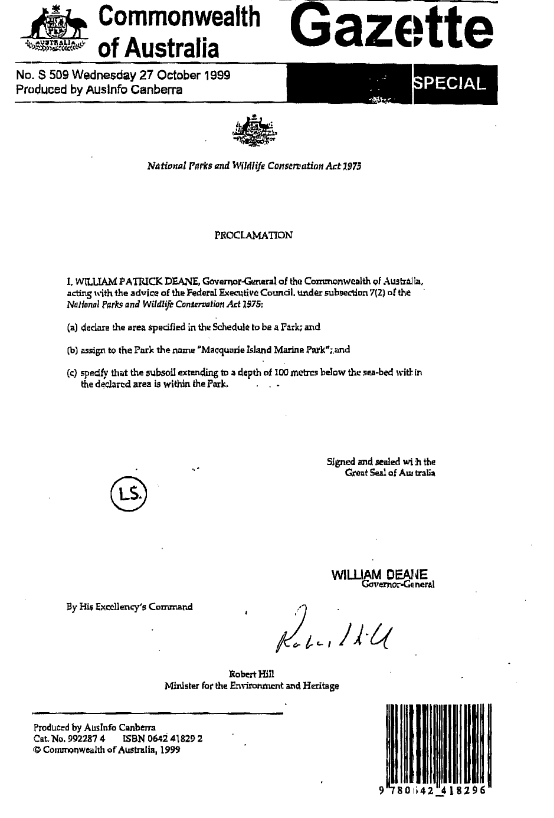
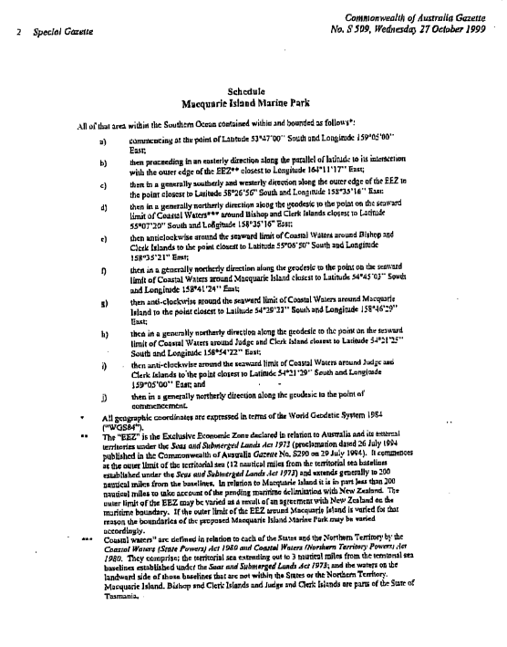
(Extract from Schedule 8 to the Environment Protection and Biodiversity Conservation Regulations 2000)
STRICT NATURE RESERVE
(Highly Protected Zone)
Note: This category corresponds to the IUCN protected area management category Ia.
The reserve or zone should be managed primarily for scientific research or environmental monitoring based on the following principles.
- Habitats, ecosystems and native species should be preserved in as undisturbed a state as possible.
- Genetic resources should be maintained in a dynamic and evolutionary state.
- Established ecological processes should be maintained.
- Structural landscape features or rock exposures should be safeguarded.
- Examples of the natural environment should be secured for scientific studies, environmental monitoring and education, including baseline areas from which all avoidable access is excluded.
- Disturbance should be minimised by careful planning and execution of research and other approved activities.
- Public access should be limited to the extent that is consistent with these principles.
HABITAT / SPECIES MANAGEMENT AREA
(Habitat/Species Management Zones)
Note: This category corresponds to the IUCN protected area management category IV
The reserve or zone should be managed primarily, including (if necessary) through active intervention, to ensure the maintenance of habitats or to meet the requirements of collections or specific species based on the following principles.
- Habitat conditions necessary to protect significant species, groups or collections of species, biotic communities or physical features of the environment should be secured and maintained, if necessary through specific human manipulation.
- Scientific research and environmental monitoring that contribute to reserve management should be facilitated as primary activities associated with sustainable resource management.
- The reserve or zone may be developed for public education and appreciation of the characteristics of habitats, species or collections and of the work of wildlife management.
- Management should seek to ensure that exploitation or occupation inconsistent with these principles does not occur.
- People with rights or interests in the reserve or zone should be entitled to benefits derived from activities in the reserve or zone that are consistent with these principles.
- If the reserve or zone is declared for the purpose of a botanic garden, it should also be managed for the increase of knowledge, appreciation and enjoyment of Australia’s plant heritage by establishing, as an integrated resource, a collection of living and herbarium specimens of Australian and related plants for study, interpretation, conservation and display.
The following principles are principles of ecologically sustainable development:
- decision-making processes should effectively integrate both long-term and short-term economic, environmental, social and equitable considerations;
- if there are threats of serious or irreversible environmental damage, lack of full scientific certainty should not be used as a reason for postponing measures to prevent environmental degradation;
- the principle of inter-generational equity—that the present generation should ensure that the health, diversity and productivity of the environment is maintained or enhanced for the benefit of future generations;
- the conservation of biological diversity and ecological integrity should be a fundamental consideration in decision-making;
- improved valuation, pricing and incentive mechanisms should be promoted.
(Source: Scott 1994, Appendix 6)
Breeding Species
Common name | Genus and species |
| |
Penguins | |
King penguin | Aptenodytes patagonicus |
Gentoo penguin | Pygoscelis papua papua |
Royal penguin | Eudyptes schlegeli |
Rockhopper penguin | Eudyptes chrysocome |
| |
Albatrosses | |
Light-mantled sooty albatross | Phoebetria palpebrata |
Black-browed albatross | Diomedea melanophris |
Grey-headed albatross | Diomedea chrysostoma |
Wandering albatross | Diomedea exulans |
| |
Petrels | |
Southern giant petrel | Macronectes giganteus |
Northern giant petrel | Macronectes halli |
Antarctic prion | Pachyptila desolata |
White-headed petrel | Pterodroma lessonii |
Sooty shearwater | Puffinus griseus |
Blue petrel | Halobaena caerulea |
Fairy prion | Pachyptila turtur |
Wilson's storm petrel | Oceanites oceanicus |
Common diving petrel | Pelecanoides urinatrix |
South Georgian diving petrel | Pelecanoides georgicus |
| |
Cormorants | |
King cormorant | Phalacrocorax albiventer purpurascens |
| |
Skuas | |
Great skua | Catharacta lonnbergi |
| |
Gulls | |
Kelp tern | Larus dominicanus |
| |
Terns | |
Antarctic tern | Sterna vittata |
Possibly Breeding Species
Common name | Genus and species |
| |
Petrels | |
Thin billed prion | Pachyptila belcheri |
Grey petrel | Procellaria cinerea |
Soft plumaged petrel | Pterodroma mollis |
Grey-backed storm petrel | Oceanites nereis |
Non-Breeding Species (Vagrants)
Common name | Genus and species |
| |
Penguins | |
Adelie penguin | Pygoscelis adeliae |
Chinstrap penguin | Pygoscelis antarctica |
Snares crested penguin | Eudyptes robustus |
Erect-crested penguin | Eudyptes sclateri |
| |
Albatrosses | |
Sooty albatross | Palpebrata fusca |
| |
Petrels | |
Cape petrel | Daption capense |
Antarctic fulmar | Fulmarus glacialoides |
Short-tailed shearwater | Puffinus tenuirostris |
Little shearwater | Puffinus assimilis |
Mottled petrel | Pterodroma inexpectata |
Antarctic petrel | Thalassoica antarctica |
| |
Cormorants | |
Black cormorant | Phalacrocorax carbo |
| |
Gannets | |
Australasian gannet | Sula serrator |
| |
Terns | |
Arctic tern | Sterna paradisaea |
(Source: Scott 1994, Appendix 7)
Breeding Species
Common name | Genus and species |
| |
Fur seals and sea lions | |
New Zealand fur seal | Arctocephalus forsteri |
Antarctic fur seal | Arctocephalus gazella |
Subantarctic fur seal | Arctocephalus tropicalis |
| |
Earless seals | |
Southern elephant seal | Mirounga leonina |
Non-Breeding Species (Vagrants)
Common name | Genus and species |
| |
Fur seals and sea lions | |
Hookers sea lion | Phocarctos hookeri |
| |
Earless seals | |
Weddell seal | Leptonychotes weddelli |
Crabeater seal | Lobodon carcinophagus |
Leopard seal | Hydrurga leptonyx |
| |
Whales | |
Southern right whale | Balaena glacialis |
Minke whlae | Balaenoptera acutorostrata |
Killer whale | Orcinus orca |
Long-fin pilot whale | Globicephala melaene |
Sperm whale | Physeter macrocephalus |
Cuviers beaked whale | Ziphius cavirostris |
Southern bottlenosed whale | Hyperoodon planifrons |
Strap-toothed whale | Mesoplodon layardii |
Blainville's beaked whale | Mesoplodon densirostris |
Andrew's beaked whale | Mesoplodon bowdoini |