Part Four(a) sets out conditions for those areas where the Commonwealth has planning approval responsibility. This includes both Designated Areas and National Land outside Designated Areas. Part Four(a) consists of:
- a map identifying land deemed to have the special characteristics of the National Capital (Designated Areas).
- Precinct and General Codes which set out the detailed conditions of planning, design and development for Designated Areas.
- Special Requirements for National Land outside Designated Areas.
Designated Areas
Designated Areas (identified in Part One of the Plan) are divided into a series of precincts. Precinct Codes and General Codes identify planning and design controls for different precincts and development types within Designated Areas. An application for works approval will be assessed against the provisions of the relevant code(s).
Precinct Codes provide objectives, and planning and design controls for defined spatial areas.
General Codes provide detailed controls for particular aspects of development or types of development.
Where inconsistencies exist between provisions of applicable Codes, Precinct Codes take precedence over General Codes.
Each identified precinct within the Central National Area, with the exception of Canberra Airport which is subject to a Master Plan under other legislation, is subject to a Precinct Code.
The Inner Hills forms part of Designated Areas, however is also part of the broader Hills, Ridges and Buffer Spaces land use category of the National Capital Open Space System (NCOSS). In treating Hills, Ridges and Buffer Spaces as a whole, provisions for the Inner Hills are located with other policies for this area in Part Three of the Plan.
Development within the Central National Area as defined in this part is also guided by a series of general principles (derived from ‘The Griffin Legacy Propositions’) and detailed conditions of planning, design and development applicable to all precincts within the Central National Area.
National Land outside Designated Areas
The Act makes provision for the Plan to set out Special Requirements for the development of any area (not being within Designated Areas), being requirements that are desirable in the interests of the National Capital. In addition to areas of Territory Land (refer Part Four(b)), Special Requirements apply to National Land outside Designated Areas.
4.0 Designated Areas
Figure 12 identifies each precinct within Designated Areas. Precincts numbered 1-15 and Canberra Airport form the Central National Area.
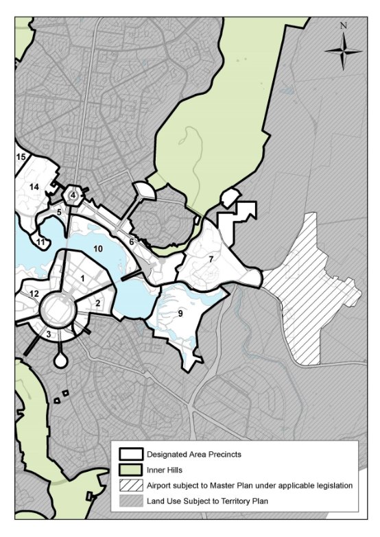
Figure 12: Designated Areas precincts
Detailed conditions of planning, design and development for each precinct are set out in a series of Precinct Codes. General policies are also applicable to the Central National Area and the Parliamentary Zone and its setting (as defined below).
4.1 The Central National Area
The Central National Area includes the following Precincts:
- Parliamentary Zone
- Barton
- Deakin/Forrest Residential Area
- City Hill
- West Basin
- Constitution Avenue and Anzac Parade
- Australian Defence Force Academy, Royal Military College Duntroon, and Campbell Park Precinct
- Australian National Botanic Gardens
- Jerrabomberra Wetlands
- Lake Burley Griffin and Foreshores
- Acton Peninsula
- Diplomatic Precinct (Yarralumla, Deakin and O’Malley)
- Australian Institute of Sport
- Australian National University
- CSIRO Black Mountain
- Canberra Airport (within the Central National Area however not within Designated Areas).
Main Avenues and Approach Routes are subject to a Precinct Code as they are within Designated Areas, but are not part of the Central National Area.
4.1.1 General policies for the Central National Area
Development in the Central National Area will be guided by the principles below. The principles direct future public and private investment in core areas of the capital where opportunities are created for vibrant, mixed use precincts alongside cultural institutions, government buildings and major national attractions. They restore the intended urbanity and vitality of Canberra as a cosmopolitan lakeside city.
The following general policies will form a basis for planning and urban design decisions for the Central National Area, its landscape setting and approaches. These include:
1. Protect the Griffins’ vision by:
- fostering recognition of the 1918 Griffin Plan as a work of national and international cultural significance, and conserve those elements that contribute to this significance in a sustainable manner whilst allowing for the evolution of the city in contemporary terms
- recognising that Canberra is a young city and ensure that future development continues to give expression to the visual geometry, built form, landscape and cultural vitality of the 1918 Griffin Plan
- recognising that some elements (for example, the Australian War Memorial and Parliament House) are successful reinterpretations of the 1918 Griffin Plan which are consistent with and strengthen the framework and spirit of the Plan.
2. Building on the Griffins’ vision by:
- maintaining the 1918 Griffin Plan as the primary organising framework of the city’s urban form, landscape and symbolism
- fostering Canberra’s unique sense of place that has evolved from the Griffins’ planning principles
- maintaining the Garden City and City Beautiful values which underpin Canberra’s quality of life
- continuing to give expression to the principles of the 1918 Griffin Plan – its visual geometry, built form, landscape spaces and cultural vitality – in order to maintain its integrity as a work of cultural significance which is internationally recognised
- continuing to reinforce and, where possible, express the integrity of the Griffins’ visual structure by strengthening the geometry and form of Main Avenues, vistas and public spaces
- refocusing the symbolic framework of the 1918 Griffin Plan by consolidating development of national symbols and spaces for commemoration and celebration on the land and water axes, and within the National Triangle
- maintaining the geometry and where practicable the fine-grain pattern of the streets and blocks of the 1918 Griffin Plan
- strengthening the landscape framework from the natural setting of the hills, water courses and parks to the character of its streets as generously-scaled corridors for formal plantings of broad-canopy trees
- maintaining the metropolitan structure principles of Canberra’s planning legacy of environmentally balanced urban extensions: design with nature; undeveloped hills and valleys; landscape containment and greenbelts; low traffic congestion; long-term public transport reservations; provision for walking and cycling; and protection of the Central National Area
- maintaining a mix of tree species which enriches the landscape by providing beauty, shade, shelter and wildlife habitats and enhances the built environment.
3. Revitalise the vision with growth in the Central National Area by:
- reinstating the Griffins’ intended unity between the Central National Area, its setting and the everyday life of the city
- delivering the richness and vitality of the Griffins’ vision by ensuring that City and surrounding neighbourhood precincts are strongly connected with the Central National Area, especially with Lake Burley Griffin and its surrounding parks
- accommodating growth in Canberra Central to contribute to a compact, sustainable city that fosters a healthy community, and offers: increased housing, employment and recreation choices; ease of movement; integrated transport and land-use; and respect for the natural environment
- developing the central areas of Canberra, such as City and Constitution Avenue, to the urban scale and diversity intended to consolidate the central areas of Canberra.
- managing change – particularly in terms of traffic and development – to preserve the historic landscapes, Garden City and City Beautiful values, and the dignity of the Central National Area
- using public investment in infrastructure to guide private investment, to enhance the vitality, accessibility and national significance of the public domain of the 1918 Griffin Plan, and to generate economic growth
- fostering a greater level of activity, choice, connectivity and accessibility in the central areas of Canberra.
4. Link the city to the Central National Area by:
- reducing the physical barriers between the Central National Area, City Centre and surrounding neighbourhood precincts
- fostering exchange between local and national activities
- harnessing the cultural and economic links between the City Centre and surrounding neighbourhood precincts
- facilitating the development of physical connections and urban form to enable greater interaction and exchange between the Australian National University, the Central National Area and City Centre.
5. Extend the City to the Lake by:
- developing a variety of waterfront activities on the Lake which are diverse in urban, recreational and ceremonial character and are accessible to the public along the waterfront
- enhancing lake-based tourist facilities and experiences
- maintaining and enhancing the ecological integrity of the lake shore through environmental management requirements for any new development adjacent to or on the lake
- developing natural drainage corridors as linear parks and pedestrian/cycle paths to connect with the lake parklands.
6. Reinforce the Main Avenues by:
- realising the identified Main Avenues of Constitution, Northbourne, Commonwealth, Kings, University, Sydney, Brisbane, and part of Canberra Avenue as multi-use boulevards providing corridors of higher-density mixed-use development, public transport, broad tree-lined footpaths with potential for outdoor dining and street parking
- preventing the Central National Area from being overwhelmed by through traffic
- providing flexible, efficient and sustainable public transport and pedestrian and bicycle systems that reduce car dependency
- developing a sufficient density and mix of land uses to support public transport
- improving the urban design and streetscape qualities of the Main Avenues as approaches to the Central National Area
- maintaining the ease and comfort of movement around the city to cater for a diversity of pedestrian, cycle, vehicular and public transport modes
- providing streets with a quality architecture and landscape character that fosters a compact, connective and pedestrian-friendly environment for central city living
- reducing the barriers of major roads to make it easier for people to access the public spaces of the city, particularly in the Central National Area.
7. Link national attractions by:
- maintaining the Central National Area as the appropriate setting for the presentation of events, ceremonies and celebrations of national and international significance, so that Australians might better understand their culture and history – and showcase them to the world
- consolidating national and international tourism activity in the Central National Area to enhance the visitor experience and appreciation of the symbolic role of Canberra as the National Capital
- developing existing and new national cultural attractions to complement the settings of existing memorials and national symbols, and to enhance economic benefits for the Australian Capital Territory community
- developing network concepts to link national attractions in the Central National Area, improving legibility and way finding for visitors, and linking existing public domain and transport networks
- engaging new cultural and government buildings with the daily life of the city by connecting them to diverse and mixed-use districts that support a range of public activities, including shopping, dining and entertainment
- reinforcing corridors of tourist activity with additional attractions and supportive land uses such as retail, restaurant and hotel developments
- protecting and enhancing ecological values of the Central National Area as a site for eco-tourism
- identifying opportunities for developing eco-tourism activities in the Central National Area, provide connections to the National Capital Open Space System, and reinforce Canberra’s identity and environmental integrity as the ‘Bush Capital’
- enhancing the provision of lake and land-based recreational and tourism opportunities within a predominantly public open space setting
- enhancing the sense of arrival for visitors to the National Capital by improving the quality of the approach routes and by progressively formalising the gateway experiences at key city thresholds, culminating in arrival at the Central National Area
- enhancing the vistas to the national attractions and icons.
4.1.2 Detailed conditions of planning, design and development
- In the Parliamentary Zone (the area bounded by the southern edge of the Lake, Kings Avenue, State Circle and Commonwealth Avenue):
- Land uses will comprise:
- Parliamentary Uses and National Capital Uses, including national legislative, judicial and executive functions, and Commonwealth cultural institutions
- such other uses, including a limited range of commercial uses and tourism facilities that complement and enhance the function and character of the area.
b. Development must be guided by the principles, policies and Indicative Development Plan for the Parliamentary Zone set out in the Parliamentary Zone Precinct Code.
2. Other parts of the Designated Areas will be used in accordance with relevant Precinct Codes.
3. Land uses will relate primarily to national functions. This should not, however, preclude the establishment of appropriate ACT Government functions, suitably located.
4. Consideration of commercial uses in those parts of the Designated Area that lie in the City will have regard to the planning effects on City as well as on the Central National Area.
5. Special consideration will be given to community, cultural, residential, tourism, entertainment and leisure uses which complement and enhance the function and character of the Designated Area.
6. Traffic capacity and traffic arrangements on major routes in the Designated Area will be planned to ensure safe and dignified access for all ceremonial occasions, and for residents, staff, tourists and visitors.
7. The transport system within the Designated Area will be planned and managed for volumes of traffic and parking consistent with the significance and use of the area. Transport infrastructure should foster the use of transport systems which minimise adverse effects from vehicular traffic.
8. The urban design of the area is to achieve an integrated design of the highest quality by managing building height and bulk, and by encouraging building forms and layouts on consistent building alignments which enhance the structure of the Griffins’ plans.
9. New development should seek to respect the design and character of adjacent buildings in terms of scale, colour, materials, massing and frontage alignment.
10. Individual development proposals will be assessed on their merits in respect to sunlight penetration, amenity, pedestrian and vehicle access. No buildings taller than RL617 will be permitted in the Designated Area, but the general building height will be 3-4 storeys except where the National Capital Authority determines otherwise.
11. Buildings in the area must show an appropriate quality of architectural design consistent with their location in this area of special national importance.
12. Direct access to and from major roads will be permitted where practicable and not inconsistent with traffic safety requirements. The design and maintenance of all roadways and parking areas, including their associated landscaping, signs and lighting, will be of a consistently high quality.
13. Commonwealth, Kings and Constitution Avenues, the avenues connecting the nodal points of the National Triangle, are of critical significance in delineating the geometric form of the Griffins’ plans. They are not only the primary movement routes, but they are powerful generators of structure and urban form. Their formal expression is paramount and is to be achieved by strong avenue planting, consistent road design, special lighting and detailing. Building heights and setbacks will be planned to ensure consistency and continuity. Setbacks for buildings adjacent to Kings and Commonwealth Avenues should generally be 15 metres. Setbacks for buildings adjacent to eastern side of Kings and western side of Commonwealth Avenues north of Lake Burley Griffin should be 10 metres.
14. Landscaping is to enhance the visual setting of the Designated Area and integrate the buildings with their landscape setting. This will be carried out in accordance with a landscape masterplan to be prepared by the National Capital Authority which particularly emphasises the following landscape themes:
- the formal and consistent landscaping of Main Avenues and mall spaces
- the combination of formal and informal landscaping which occurs around the Lake’s edge and is the setting for Parliament House and its adjacent area.
- Residential blocks must not be subdivided for separate occupation.
- Any proposal to subdivide land within the Central National Area will require the approval of the National Capital Authority.
4.2.1 Background
The Parliamentary Zone and Its Setting comprises the Parliamentary Zone, Diplomatic (Yarralumla), Deakin/Forrest Residential Area, Barton, City Hill, West Basin, and Constitution Avenue and Anzac Parade Precincts.
The National Capital and Seat of Government is the legislative, judicial, administrative, executive, ceremonial and symbolic centre of the nation.
The role of Canberra as the National Capital warrants high environmental and aesthetic standards for development generally. It also requires that national functions are located where they may operate effectively and efficiently.
Areas that clearly exhibit the special characteristics of the National Capital primarily have the Parliamentary Zone and its setting as their focus. They embrace the main National Capital uses and national institutions, and other centrally located areas of National Land, diplomatic areas, and nearby lands where planning, design and development are critical.
The core of those areas is the Parliamentary Zone – the physical manifestation of Australian democratic government and the home of the nation’s most important cultural and judicial institutions and symbols.
The area ensures that the essential relationships between Parliament and its setting are planned, developed and conserved in an integrated way, with the Commonwealth providing the requisite leadership of design and ensuring that construction and maintenance operations are carried out to the highest standards.
Urban design is concerned with the arrangement of buildings and spaces to achieve harmony, interest, attractiveness, vitality and legibility. Specific urban design policies are concerned with ensuring that the quality of the built environment results in a composition which is consistent in scale and image.
The subject area is the centre for all the nationally significant activities of Parliament, the Judiciary and government and is the focal point of visitor interest in the National Capital.
A Masterplan for the Parliamentary Zone (refer to the Parliamentary Zone Precinct Code) guides all future development in the Zone.
Within the Parliamentary Zone, the National Capital Authority’s statutory responsibility for the approval of works in Designated Areas does not affect section 5 of the Parliament Act 1974 which provides at subsection (1) that:
no building or other work is to be erected on land within the Parliamentary Zone unless:
- if the land is within the precincts as defined by subsection 3(1) of the Parliamentary Precincts Act 1988 – the President of the Senate and the Speaker of the House of Representatives jointly have; or
- in any other case – the Minister has;
caused a proposal for the erection of a building or work to be laid before each House of the Parliament and the proposal has been approved by resolution of each House.
The combined effect of the Act, the Parliament Act 1974 and the Parliamentary Precincts Act 1988, is that within the Parliamentary Zone (which includes the Parliamentary Precincts), Works as defined by the Act require approval by National Capital Authority in addition to any Parliamentary approvals necessary under the other Acts.
Within the Parliamentary Precincts (generally within Capital Circle) the Presiding Officers have responsibility for control and management. In the exercise of this responsibility, any actions falling within the definition of Works set out in the Act continue to require approval by National Capital Authority.
The Plan includes City Hill and the area inside London Circuit as part of the Designated Area. City Hill is one of the three corners of the National Triangle formed by Commonwealth, Kings and Constitution Avenues, and as such the character of its future development and that of the area adjoining it is crucial to the long-term character of the National Capital.
Linking City Hill with Russell is Constitution Avenue. The Plan provides for development beside the Avenue which establishes it as a formal urban avenue. Since design issues will be crucial in setting the character of the Avenue, both sides of Constitution Avenue are included in the Designated Areas.
Land fronting the Approach Routes and avenues which were an important symbolic component of the Griffins’ plans is also considered to have special National Capital interest. Special Requirements have been established for these areas.
4.2.2 Detailed conditions of planning, design and development
4.2.2.1 Principles for the Parliamentary Zone and its Setting
- Canberra’s role as Australia’s capital is of continuing and paramount importance. National functions, organisations and activities are actively encouraged to locate in Canberra. They should be housed and located in prominent positions where they serve, individually and collectively, as effective symbols of the nation and its capital.
- Opportunities should be taken progressively to enhance the international role of Canberra as Australia’s capital. Diplomatic representation, the establishment in Canberra of international organisations, and the holding of international events in Canberra are all encouraged as means of enhancing the National Capital’s international role.
- The planning and development of the National Capital will seek to respect and enhance the main principles of the Griffins’ formally adopted plan for Canberra.
- The Parliamentary Zone and its setting remain the heart of the National Capital. In this area, priority will be given to the development of buildings and associated structures which have activities and functions that symbolise the Capital and through it the nation. Other developments in the area should be sited and designed to support the prominence of these national functions and reinforce the character of the area.
- Planning and development of the Territory beyond the Parliamentary Zone and its setting should enhance the national significance of both Canberra and the Territory.
4.2.2.2 Policies for the Parliamentary Zone and its setting
- Major national functions and activities that are closely connected with workings of Parliament or are of major national significance should be located in or adjacent to the National Triangle formed by Commonwealth, Kings and Constitution Avenues, to provide a strong physical and functional structure which symbolises the role of Canberra as the National Capital.
- The preferred uses in the Parliamentary Zone are those that arise from its role as the physical manifestation of Australian democratic government and as the home of the nation’s most important cultural and judicial institutions and symbols. The highest standards of architecture will be sought for buildings located in the Parliamentary Zone.
- Diplomatic activities should be established in places which are prestigious, have good access to Parliament House and other designated diplomatic precincts, and meet security requirements. They should be planned and designed to establish a distinct character and setting for each area reflecting their national and international significance.
- National and international associations and institutions will be encouraged to locate in Canberra, and whenever practicable the District of Canberra Central will be the preferred location for them.
4.3.1 Precinct location
The Parliamentary Zone Precinct consists of the Parliamentary Zone, being the eastern side of the Commonwealth Avenue road reserve between State Circle and the southern shore of the Lake, Capital Hill, and the western side of the Kings Avenue road reserve between State Circle and the southern shore of the Lake.
The Parliamentary Zone is the area of land bounded by a line commencing at a point where the eastern boundary of Commonwealth Avenue intersects the inner boundary of State Circle and proceeding thence in a northerly direction along the eastern boundary of Commonwealth Avenue until it intersections the southern shore of the Lake, thence in a generally easterly direction along that shore until it intersects the western boundary of Kings Avenue, thence in a south westerly direction along that boundary until it intersects the inner boundary of State Circle, and thence clockwise around that inner boundary to the point of commencement.
Capital Hill includes the land enclosed by State Circle, and that part of the road reserve of State Circle immediately adjacent to Capital Hill.
Figure 13 illustrates the location of the Parliamentary Zone Precinct.
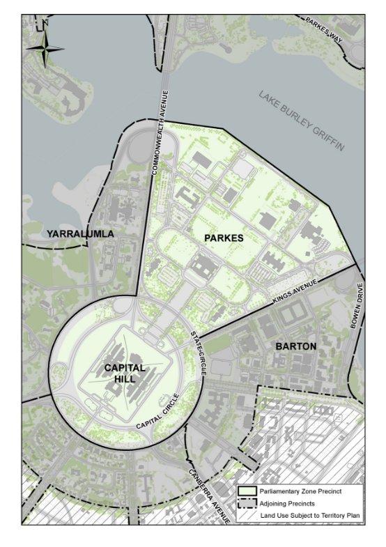
Figure 13: The Parliamentary Zone Precinct location
4.3.2 Background
The Parliamentary Zone Precinct is the physical manifestation of Australian democratic government and the home of the nation’s most importance cultural and judicial institutions and symbols. The Parliamentary Zone is the symbolic heart of the National Capital and is at the geometric centre of the Griffins’ plans for Canberra.
4.3.3 Objectives for the Parliamentary Zone Precinct
The Parliamentary Zone will be given meaning as the place of the people, accessible to all Australians so that they can more fully understand and appreciate the collective experience and rich diversity of this country.
To do this, the place of the people must reflect:
- the political and cultural role of Australia’s Capital
- federation and Australian democracy
- the achievements of individual Australians in all areas of endeavour
- the diversity of Australia, its peoples, natural environments, cultures and heritage
- the unique qualities of Australian creativity and craftsmanship.
The place of the people must have:
- a sense of scale, dignity and openness
- a cohesive and comprehensible layout
- a large forum for public ceremony and debate
- intimate, enjoyable spaces for individuals and groups
- a dynamic program of national, state and regional events
- accessible and affordable public facilities.
To realise the Parliamentary Zone as the place of the people it will be important to:
- balance politics and culture
- welcome people
- celebrate Australian history and society
- represent Australian excellence
- emphasise the importance of the public realm
- make access easy and open
- reinforce the integrity of the visual structure
- strengthen the relationship between buildings and landscape
- create a variety of urban spaces
- establish comprehensive design management polices for the future.
For each of these objectives, stated intentions that will guide all developmental and cultural and physical planning and management are as follows.
Objective | Intention |
Balance politics and culture | locate national cultural institutions and key government agencies in the place of the people facilitate the staging of cultural and political events, activities and ceremonies provide opportunities to recognise Australian endeavour |
Welcome people | encourage the diverse population of Australia to visit provide spaces that are pleasant and sheltered improve the level of amenity and engender vitality (cafés, events, picnic spaces, etcetera) establish a program of appropriate events and activities in quality venues provide visitor-friendly public transport and car parking discourage through-traffic and encourage pedestrians and cyclists make it easy for people to find their destination |
Celebrate Australian history and society | create ceremonial and community events that reflect our nation's history, spirit and aspirations recognise the rich history and contribution of the Indigenous Australian people and of our multicultural society provide opportunities for people to interpret the role of government, the history of our nation and Australian achievement foster a sense of affinity and attachment to the National Capital conserve the unique heritage of the Parliamentary Zone for future generations |
Represent Australian excellence | encourage the exemplary use of Australian innovation, creativity and diversity use Australian materials and craftsmanship demonstrate sustainable management practices adopt leading practice design and architecture |
Emphasise the importance of the public realm | encourage pedestrian activity improve the amenity of the open spaces establish a variety of public spaces that will support a range of activities establish a hierarchy of public spaces with the Land Axis as the principal space create a major focus for public representation provide good signage and interpretative systems |
Make access easy and open | provide a comprehensive system of paths, cycleways and roads make public spaces safe ensure that design is barrier free improve public transport locate car parks where they are central, safe and secure establish well signed, convenient routes to major destinations clearly identify the front entries to buildings |
Reinforce the integrity of the visual structure | maintain the integrity and prominence of the Land Axis symbolically recognise the intersection of the Land Axis and Water Axis emphasise Commonwealth and Kings Avenues as landscape edges align buildings normal to the Land Axis and Water Axis and to the Griffins’ proposed terraces enhance the existing character and quality of the landscape use lighting to emphasise the organisational structure, buildings and other special features plant trees to reflect seasonal changes |
Strengthen the relationship between buildings and landscape | provide ordered settings and relate buildings of similar functions, using the existing buildings as the focus locate a central court for each development group provide clear address and identity for all buildings from the central court align buildings normal to the Land Axis and Water Axis establish vistas from the Land Axis to the central development courts enhance seasonal, day and night landscape settings for buildings |
Create a variety of urban spaces | establish a sequence of spaces that range from the Land Axis to the development courts provide a major focus for public representation and gatherings of national interest create spaces that will support vibrant activities of discovery and others for reflection or quiet enjoyment link buildings and places with a legible road and pathway network |
Establish comprehensive design management polices for the future | reserve sites for new buildings plan for a mix of appropriate future functions and land uses establish a viable financial framework for development and management provide a defined role for private capital, patronage and sponsorship develop sustainable environmental management practices conserve the unique heritage of the Parliamentary Zone for future generations |
4.3.4 Land use for Parliamentary Zone Precinct
Land use for the Parliamentary Zone should be in accordance with Figure 14.
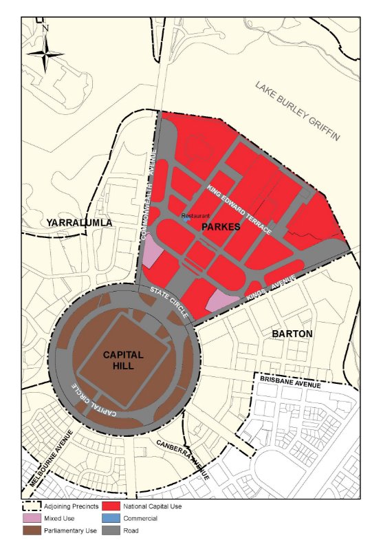
Figure 14: Land use for the Parliamentary Zone Precinct
Permitted land uses for ‘Mixed Use’ are:
- Commercial Accommodation (Hotel, Motel and Serviced Apartments only)
- Community Use
- National Association Office
- National Capital Use
- Office
- Parliamentary Use
- Place of Assembly.
Permitted ancillary land uses for ‘Mixed Use’ are:
- Café
- Car Park
- Child Care Centre
- Consulting Rooms
- Personal Services Establishment
- Retail
- Restaurant.
4.3.5 Detailed conditions of planning, design and development
Formation of campuses
Identifiable precincts, or campuses, should be created to provide a sensible and flexible rationale for the location of new buildings, public spaces, commemorative works and even some events.
Essentially, the policy is to use the existing buildings as 'anchors' for new development that has a compatible function. For example, a new government agency could be sited adjacent to either the John Gorton or Treasury buildings, while a new visual arts building could be located near the National Gallery of Australia. Similarly, any planned extensions to Parliament would be ideally placed on what was Camp Hill between the Old and New Houses of Parliament.
While the existing buildings will determine the character of the functions and uses for each campus, a court, plaza or garden should provide the focus to their layout. Each building in the campus, existing and new, should have a pedestrian entry fronting the court, and the courts themselves should be developed so that they encourage people to use them for informal lunch time sports, or for celebrations or perhaps protests.
The existing buildings will also influence the architectural and landscape character for each of the campuses. Urban design guidelines addressing aspects such as form, materials, scale and footprint should ensure that successive development contributes to the integrity of the campus. Gradually this will break the Zone into distinguishable precincts, which in turn will make the Zone more visitor-friendly.
To ensure that people can move easily between the campuses, the campuses will be connected by paths and vistas created from one central court to the other. To ensure that people can orientate themselves in the Zone, view corridors from the courts to the Lake or Parliament House will also be established.
Five campuses are to be formed in the Zone, with Parliament House as a sixth, as follows:
- 'Parliamentary Executive' campus, centred on Old Parliament House
- 'Treasury' campus around that building
- 'John Gorton' campus around that building
- 'Humanities and Science' campus, built around the National Library of Australia and the National Science and Technology Centre
- 'Arts and Civic' campus built around the National Gallery of Australia and the High Court of Australia.
The general arrangement of each of these campuses is identified in Figure 15.
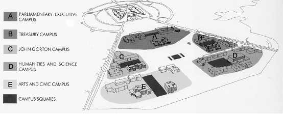
Figure 15: Parliamentary Zone - Formation of campuses
Land use and development
For the place of the people to remain relevant, a balance should be maintained between the working political functions of the seat of Government and the national cultural institutions. Major shifts in this balance would make the Parliamentary Zone into either a theme park of attractions or an office environment devoid of people outside of working hours.
Permissible land uses include parliamentary uses, appropriate National Capital uses and other uses that enhance the function and character of the area.
In recognition of an anticipated 50-year timeframe for future developments including buildings, landscapes and associated works, a number of sites within the Parliamentary Zone should be reserved for future use in four main categories:
- Seat of Government – Commonwealth Parliament of Australia
- Seat of Government – Agencies of the Commonwealth of Australia
- national (cultural) institutions
- facilities and amenities for the public.
In the event that Parliament House needs to expand to accommodate growth in its working population, expansion should be directed into the two existing car parks located either side of Federation Mall between East Block and West Block. Buildings should be three storeys in addition to multi-level basement car parking.
Future growth of government agency functions should be directed into the campuses located around the Treasury and John Gorton buildings. Because they are near the centre of the Parliamentary Zone and house large worker populations, these two campuses should also be the locations for low-scale structured car parks. The car parks may additionally house future shuttle bus services, as well as limited retail amenities such as dry cleaners, newsagents and flower shops.
Any future expansion of the National Gallery of Australia and the National Archives of Australia should occur on sites adjacent to the present locations of these national institutions.
Any long-term requirements for new cultural institutions should also be accommodated in the proposed campuses. There are ample new building sites (many currently used for surface parking) associated with the Arts and Civic campus and the Humanities and Science Campus.
The site to the west of the Land Axis and east of Parkes Place West (currently a surface car park) is a high profile site. The site should be reserved for a significant national building and/or a significant national place of special status and interest.
King Edward Terrace should develop a 'mainstream character' over time with intersection changes, additional pedestrian crossings, broader paths and more consistent avenue planting. To reinforce this character, concessions and convenient services for the public should be provided along the Terrace.
Finally, the new focus of public activities in the place of the people, the area adjoining the south side of Queen Elizabeth Terrace on the lake edge and centred on the Land Axis, should provide amenities and facilities such as restaurants, coffee shops, and exhibitions for the public.
Roads and traffic
Traffic is an important aspect of realising the objectives for the Parliamentary Zone. Commonwealth and Kings Avenues are major traffic routes connecting the north and south of Canberra and both carry large volumes of peak hour traffic. More importantly, commuters travelling to and from City, Barton and Fyshwick use the east-west roads that go through the Parliamentary Zone, i.e. King Edward, King George and Queen Victoria Terraces.
A disproportionate amount of through-traffic uses King Edward Terrace and as a consequence there is a number of traffic and pedestrian safety matters.
To assist in ameliorating some of the through-traffic, a number of improvements to the road layout and design should be introduced progressively. These include:
- Establishing a legible hierarchy in the roads by giving each a different character, drawn from variables such as the road surface and width, avenue planting and directional signage. In this way Commonwealth and Kings Avenues will be distinguished as the primary access roads, King Edward and King George Terraces as secondary address roads and Parkes Place, Queen Victoria Terrace and Federation Mall as the tertiary distributors. The lanes within the campuses that lead to building entries or to car parks should be developed as shared zones for pedestrians and cars.
- Changing King Edward Terrace from a thoroughfare to a main street. This can be achieved by creating 'T' intersections and traffic lights at its junctions with Commonwealth and Kings Avenues, by rationalising the number of entry points to the campuses and by adding pedestrian crossing points to provide continuity in the path system. With the exception of service vehicles and tourist coaches, a load limit should also be considered as a traffic calming and safety measure.
- Removing Bowen Place, Flynn Place, and the straight sections of Langton Crescent and Dorothy Tangney Place. These roads were built to a large scale in the expectation that Parliament House would be built on the lakeshore rather than on Capital Hill. Their removal is possible if 'T' intersections are made at the intersections of King Edward Terrace, Commonwealth and Kings Avenues.
Pedestrian pathways
Direct, sheltered paths connecting major destinations will substantially improve the public realm of the Parliamentary Zone. Encouraging people to leave their cars in one destination and to explore the attractions of the Zone as pedestrians will add to the vibrancy and life of the place of the people.
A legible and consistent path system that connects all the parts of the Parliamentary Zone will be introduced gradually and progressively.
The first paths to be installed should be in the northern part of the Zone, linking King Edward Terrace and the Lake. Linking with the pathways that now terminate at the northern edge of Parkes Place, the new paths should run down each side of the open space that forms the Land Axis to the Lake. Pedestrian crossings are to be provided on King Edward Terrace along these paths at appropriate points to afford a safe pedestrian environment.
In the vicinity of Old Parliament House, the existing perimeter roads should be upgraded through the use of extended paving to enhance pedestrian movement but in a manner that has regard to the conservation values of the historic setting of the building and still capable of meeting the functional requirements of the building. This would give the building an appropriate, dignified setting and create a generous new pedestrian environment. To further connect Old Parliament House with the other parts of the Parliamentary Zone, some form of secondary entry should be created at the rear of the building facing Parliament House.
In association with the paths, cycle access for both commuter and recreational cyclists will be provided. The cycleway network should be linked to the existing system, encouraging access and especially cycling around the Lake. All major attractions should be similarly connected, and secure facilities for cycle storage should be installed at these locations.
Orientation and interpretation
Good orientation and interpretation will help to create a positive first impression and an enjoyable experience for people visiting the Parliamentary Zone and assist their understanding about the National Capital.
A hierarchical signage system to assist people in finding their way around the Parliamentary Zone and reinforce it as a special area is to be produced. The system should include:
- identification signs that relate to street entrances of the key national institutions and public places
- secondary signs that relate to the public entrances of the buildings
- directional signs for traffic and pedestrians to indicate the routes to buildings and other destinations
- information signs on services for pedestrians and tourists
- interpretative signs providing information about places, events and venues.
This system should ensure continuity in the form of the sign, consistency in message content and easy updating and extension.
Interpretative signs are to be included at commemorative and dedication points and at the entrances to gardens, places and venues. These signs should provide brief notes on the historical background, cultural significance and importance of these places.
Tree planting
Tree planting is fundamental to the enduring design concept of Canberra and to the character and structure of the city. It is the formal tree planting that reflects the ground pattern of roads and formal spaces and establishes their character and beauty. New planting should be introduced and existing planting strengthened and conserved to attract native birdlife and create shelter, scale, interest and a special character to each of the campuses.
The Land Axis and Commonwealth and Kings Avenues are important elements in making the Parliamentary Zone legible. To maintain the definition of the geometry of the Zone, there must be a long-term strategy for the replacement of trees.
With its central location, length, width and the stark contrast between the turf and the eucalypts, the Land Axis has a powerful presence in the Parliamentary Zone. Trees should be replaced and the planting extended where appropriate to preserve the visual strength of the Land Axis.
The tree planting on Commonwealth and Kings Avenues reflects different attitudes to avenue planting over the generations. There is an assortment of native, coniferous and deciduous species that requires rationalisation. The original design intent of the avenue planting – to provide a backdrop of coniferous evergreen trees contrasting with the deciduous trees at the street edge – made the avenues legible in the broader landscape and distinctive throughout the seasons. A consistent approach to replacement tree planting should be undertaken to reinstate this intent.
There are other formal spaces that reflect the Griffins’ Plan with its terracing, and the 1920s road layout. These spaces and streets, which include Parkes Place and Queen Victoria, King George and King Edward Terraces, create a series of important cross axes and lateral spaces. The trees that establish these spaces are a mixture of exotic evergreen and deciduous species.
A consistent approach to replacement planting should be adopted to conserve the clarity and character of these spaces. For example, red autumn foliage along the avenues, with accents of yellow at intersection points, will help to define special routes and places of interest. The brighter foliage of deciduous trees will also emphasise the major groupings of buildings and offer sun and shade control at various times of the year.
The East-West promenade between the National Gallery of Australia and the National Library of Australia will create a major new lateral space. Here, tree planting should be used to identify this as a new cross axis mimicking the older tree planting of the avenues.
Indicative development plan
The Indicative Development Plan at Figure 16 indicates how growth and development is intended to look in the long term. The Indicative Development Plan should be used to guide all future planning and development in the Parliamentary Zone.
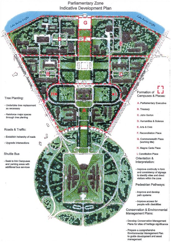
Figure 16: Parliamentary Zone - Indicative development plan
The Barton Precinct is bounded by Kings Avenue and the Parliamentary Zone to the north and the edge of Lake Burley Griffin to the east. The southern perimeter runs along Brisbane Avenue, down National Circuit around Sydney Avenue and ends at Canberra Avenue. State Circle and the curtilage of St Andrew’s Church form the western boundary of the precinct.
Figure 17 illustrates the location of the Barton Precinct.
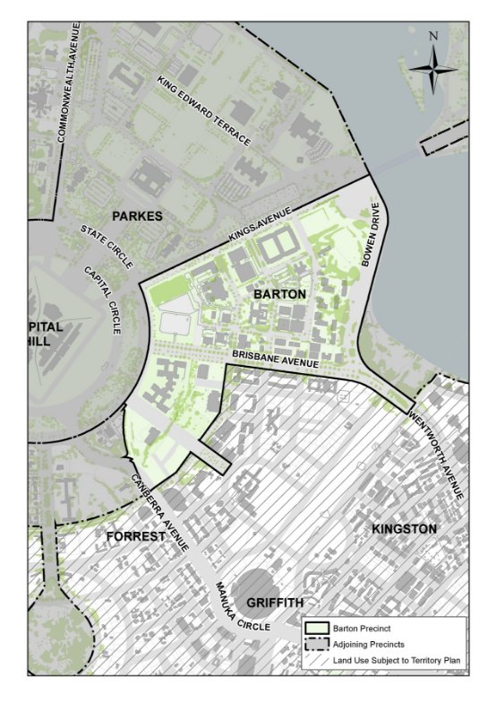
Figure 17: Barton Precinct location
Barton has long been recognised as a prestigious office location and is characterised by a series of large buildings set in a generous landscape setting. A number of key government agencies are located in the area, including the Department of Foreign Affairs and Trade, Australian Federal Police, Australian National Audit Office, Department of the Prime Minister and Cabinet and the Attorney-General’s Department. Smaller Australian Government agencies and private sector offices (often providing services to government) have also established in Barton.
- Ensure the highest standards of architecture for all buildings in the precinct.
- Ensure that individual buildings contribute to the coherent definition of streets, blocks and public spaces intended for the Precinct.
- Create a legible network of paths and streets and enhance connectivity and accessibility to the Lake.
- Encourage a mix of land uses which contribute to the vibrancy, amenity and convenience of the Barton Precinct as an attractive place in which to work and live.
- Ensure new development meets leading practice for environmental sustainability including energy efficiency and water sensitive urban design measures.
- Ensure development recognises and complements the precinct character; as a major employment centre and area of national importance.
- Recognise and reinforce the different streetscapes associated with Kings, Brisbane, and Sydney Avenues, and State Circle.
Land use for the Barton Precinct should be in accordance with Figure 18.
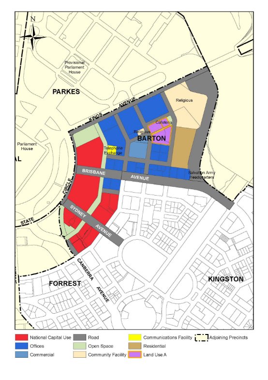
Figure 18: Land use for the Barton Precinct
4.4.5 Detailed conditions of planning, design and development
Building height
A building height limit of RL 591 generally applies to the Barton area. This level corresponds with the level of the parapet walls at all four corners of Parliament Drive and establishes an appropriate limit in terms of creating and maintaining built form relationships to Parliament House when seen from vantage points in and around the Central National Area.
Minor building elements (such as lift overruns and roof plant) that extend building height above RL 591 will be considered where this enhances the architectural quality of the building, and fosters energy efficiency, indoor amenity, appropriate urban scale, and adds visual interest to the skyline. Minor building elements should be carefully integrated within the form of buildings.
Lift overruns, plant rooms and any roof mounted aerials, masts and dishes should be designed and sited to have a low visual impact when viewed from the street or Parliament House.
At Section 1 Barton, buildings up to RL 602, inclusive of plant and roof height, may be considered where they add visual interest to the skyline and are set back from the Main Avenue frontages. Individual consideration will also be given to special vertical elements such as a spire or tower associated with a cathedral building on Block 31 Section 6 Barton.
Buildings should be a minimum of four storeys on the Main Avenue frontages of Kings Avenue, Brisbane Avenue and Sydney Avenue.
A high quality of landscape design is sought and mature trees are to be retained wherever possible.
Street trees and other large trees are to be planted in deep-root soil conditions.
Windsor Walk will be constructed and landscaped to form the main pedestrian spine through the Barton Precinct.
Cycle ways and pedestrian paths will be provided to enable safe and convenient movement and should connect to major peripheral paths.
Pedestrian safety and visual amenity should be secured through traffic calming and appropriate streetscape design.
New development should provide a positive address to pedestrian areas, to provide visual interest, activity and passive surveillance. Blank façades and exposed service areas should generally be avoided.
Opportunities for linking the pedestrian networks of the Barton Precinct with the surrounding areas such as the trail system in the peripheral parklands of Parliament House should be addressed by new developments, particularly in the development of Section 1 Barton.
Promote environmentally sustainable development including increased pedestrian and cycle accessibility and public transport use while reducing dependency on private vehicles.
Public domain works and site infrastructure should be implemented concurrently with new adjoining development.
New developments may be required to provide public infrastructure, including adjacent access roads and landscaped public spaces such as Windsor Walk, in accordance with detailed development requirements set by the National Capital Authority.
York Park Area
Background
The development of York Park and environs is primarily to accommodate prestigious offices requiring proximity to Parliament House. York Park occupies a prominent site in the Central National Area and contributes to the urban form and landscape features which give the National Capital its special character and setting. It forms part of the backdrop and approaches to Parliament House and an edge to the National Triangle at Kings Avenue. York Park has a key role in the daily functions of government, provides sites for the headquarters of major national associations and plays an international role in receiving visiting officials and dignitaries. Consequently, it is necessary that development of York Park and its public domain should achieve design excellence of a high order.
‘York Park’ is the gazetted name of the areas contained within Sections 1 and 15 Barton and Section 29 Forrest (named after commemorative tree plantings by HRH the Duke of York in 1927). However, for the purposes of the Precinct Code ‘York Park’ refers also to the environs beyond these Sections and includes all of the area between National Circuit, Canberra Avenue, State Circle and Kings Avenue.
The York Park area should be developed primarily as a prestigious office area and landscape setting to satisfy demand for office accommodation requiring proximity to Parliament House.
The urban structure and character of York Park should reflect the geometry and intent of the Griffins’ plans, and provide a legible hierarchy of streets and public spaces.
Development should respect the geometry and symbolic intent of the Griffins’ plans, particularly the vistas to and from Parliament House and the connections to national institutions, monuments and landscape spaces in and around the Parliamentary Zone.
Architectural excellence is essential for development in York Park, commensurate with its location adjacent to Parliament House.
High quality landscape design is essential for the development of York Park as a prestigious setting for National Capital uses and offices.
The landscape design of streets, pedestrian paths and open spaces of York Park should consist of a range of formal and informal spaces that reinforce the Griffin geometry and contribute to the landscape setting of Parliament House.
The public domain of York Park should provide for places for local recreation with a high level of pedestrian amenity.
Individual buildings should contribute to the coherent definition of streets, blocks and public spaces, form the public domain of the precinct, and contribute to the public domain’s active pedestrian qualities.
Greater use of public transport should be encouraged, particularly for the journey to work. As should less, or more efficient, use of private transport.
Safe and convenient movement systems for pedestrians and cyclists should be provided within the precinct.
Significant natural and heritage values of the area should be identified and protected.
Development and redevelopment should accord with the detailed conditions of planning, design and development below.
Permitted land uses for the York Park area generally are:
- Diplomatic Mission (with the exception of Blocks 3 and 15 Section 22 Barton)
- National Capital Use
- Office (which may include Commonwealth offices and offices for national associations)
- Open Space.
Permitted ancillary uses are:
- Retail
- Personal Service Establishment
- Child Care Centre.
Additional permitted land uses for Blocks 3 and 15 Section 22 Barton are:
- Commercial Accommodation (not including a caravan park/camping ground)
- Residential.
- Additional permitted ancillary land uses for Blocks 3 and 15 Section 22 Barton are:
- Café
- Restaurant.
Commercial parking structures in the York Park area are to be located where identified on the Indicative Development Plan at Figure 19. Retail and Personal Service Establishments are permitted at the ground level of parking structures as ancillary small scale facilities.
Retail and Personal Service Establishments should be provided at the ground floor level of Offices and structured Car Parks in the location identified for a ‘Retail Plaza’ on the Indicative Development Plans at Figure 19 and Figure 22.
Large spaces for recreation are to be provided at either end of Windsor Walk including a large space suitable for active recreation at the Canberra Avenue end of Windsor Walk as depicted in Figure 19.
Detailed conditions of planning, design and development
Building orientation
Buildings are to be sited parallel with the Avenues (Kings Avenue, Brisbane Avenue and Sydney Avenue), with National Circuit and State Circle, to provide definition to the geometry of the Griffin’s Plans with built form.
Car parking
Surface car parks are inappropriate as foreground to the views from Parliament House and, to the extent they are permitted on a temporary basis, they are to be carefully screened with landscaping.
Basement car parks should be constructed below finished ground level and concealed from public streets and pedestrian areas.
Multi storey parking structures are to be designed to minimise their visual and physical impacts on the important public streetscapes of the Main Avenues and Windsor Walk.
A parking structure, if provided on the corner of Windsor Walk and Brisbane Avenue, should be located behind a screen of habitable retail/office buildings with address frontages to Brisbane Avenue and Windsor Walk and integrated in design with the retail/office buildings.
Particular attention should be given to the design of roofing to parking structures to relieve the visual impact of large roof areas. A maximum height below RL 591 may apply to parking structures to relieve their visual and physical impact on the public domain.
Undercroft parking, that is, open parking basements projecting above ground level, will only be permitted where the National Capital Authority is satisfied that it does not limit the opportunity to create attractive landscape areas, and will not be permitted on public street frontages and Windsor Walk.
Parking policies for the York Park area are designed to encourage greater use of public transport for the journey to work.
An overall reduction in the total long-term car parking provision is proposed. This will be achieved by initially limiting the amount of on-site parking permitted in new developments.
On-site car parking should be provided, at a rate of 1 space per 100 square metres of gross floor area, for new offices approved in the York Park area. A higher on-site and/or off-site provision may be required by the National Capital Authority in specific cases, after taking into account the relationship between on-site parking, off-site parking opportunities and the capacity of public transport in the area.
Parking for non-office uses will be provided at rates consistent with the standards of the ACT Government.
Surface car parks on unleased land will be progressively replaced by strategically located multi-level parking structures and/or underground parking areas. Supplementary car parking in temporary surface car parks may be provided pending the development of these parking facilities.
If for specific sites the National Capital Authority determines that the amount of parking to be provided should be above the minimum on-site amount specified in the requirement above, this additional parking may be provided either on-site, or by way of a contribution to the ACT Government for off-site provision of that parking in the locality, or by a combination of these methods.
Building height
To protect the integrity of views to and from Parliament House, development is generally limited to a maximum height of RL 591.
On Section 1 Barton, buildings up to RL 602, inclusive of plant and roof height, may be considered where they add visual interest to the skyline, are set back from the Main Avenue frontages, and ensure that Parliament House remains pre-eminent in views from elevated viewing points such as Mount Ainslie and from the East Basin of Lake Burley Griffin.
As Parliament House is sited above York Park, the roofscapes of buildings warrant particular attention. Roof plant is to be carefully integrated and enclosed within the roof form. Minor roofscape elements will be permitted to extend above the RL 591 height limit, to an extent not exceeding that of the RG Casey building, to add visual interest to the skyline.
Buildings should be a minimum of four storeys on the Main Avenue frontages.
Building setbacks
Building setbacks have been established for Kings, Sydney and Brisbane Avenues within the York Park area as follows:
- 15 metres for buildings along Kings Avenue
- ten metres on Brisbane Avenue
- six metres on Sydney Avenue.
On State Circle, a variable setback of a minimum of 20 metres is to apply, to allow the buildings to merge visually and spatially with the informal character of the woodland landscape surrounding Capital Hill.
Building articulation and entries
Drop off points and minor architectural elements, which articulate and enhance the building elevation, will be considered within front setback zones.
High quality paving, lighting and bollards, integrated with soft landscape treatments, are required within site boundaries to complement the standards set and maintained in the public domain.
All buildings on blocks with a frontage to Kings, Brisbane or Sydney Avenue should generally have a significant entry facing the avenue.
Spaces in front of building setbacks are to be landscaped to reinforce the theme of York Park as prestigious buildings in a landscape setting.
External security barriers, if required, such as bollards and retaining walls, should be designed as integral and attractive elements of the civic landscape of York Park.
Services and service entries should be concealed from Main Avenues and pedestrian pathways.
The number of vehicle crossings should be kept to a minimum, to enhance the amenity and safety of pedestrian paths.
Landscape
The landscape setting of York Park will consist of a range of formal and informal spaces that reinforce the geometry of the Griffins’ plans and contribute to the setting of Parliament House.
Landscape design in York Park will be of a high quality, commensurate with the location adjacent to Parliament House and places of national significance within the Central National Area.
Landscaping of frontages to State Circle will generally be informal, and similar in character to the native woodlands surrounding Parliament House, in order to visually connect York Park to Capital Hill and contribute to its landscape setting.
The design of car parking areas and arrival courts should incorporate generously scaled tree planting beds to provide shade and separation to parking bays. Quality streetscape furnishings and paving treatments are to be utilised to provide visual relief to surface car parks and vehicular areas within or adjacent to places characterised by higher levels of pedestrian use.
Building form
High quality, prestigious and durable building materials are required to be used for all developments.
New buildings should complement, but not necessarily imitate, the style, colour, form, scale and finishes of surrounding buildings.
Unpainted or galvanised metal will not be permitted on roofs, parapets or fascias.
Lift overruns, plant rooms and any roof mounted aerials, masts and dishes should be designed and sited to have a low visual impact when viewed from the street or Parliament House.
Internal courtyards of office buildings should generally provide deep in-ground planting conditions and be of a dimension suitable for establishing large trees.
Open Space
Windsor Walk is to serve as a central linear park and continuous pedestrian spine connecting public car parks, office destinations, the proposed retail plaza and a variety of landscaped recreation areas. It is to provide spaces for active recreation as well as quiet outdoor places for workers to enjoy during the day. Nodes of intimate formal parks are to be developed as accents within an otherwise informal woodland character extending the length of the walk. Larger spaces for recreation are to be provided at either end of Windsor Walk.
Windsor Walk is to be developed and retained as landscaped open space. Windsor Walk will be constructed and landscaped to form the main pedestrian spine through the York Park precinct.
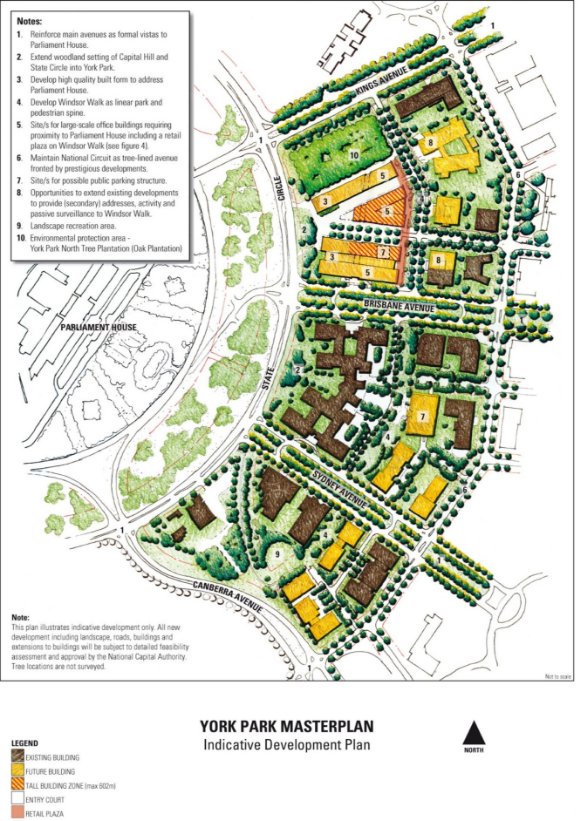
Figure 19: York Park Masterplan – Indicative development plan
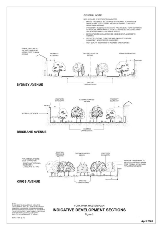
Figure 20: York Park Masterplan – Indicative sections (1)
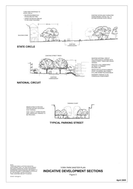
Figure 21: York Park Masterplan – Indicative sections (2)
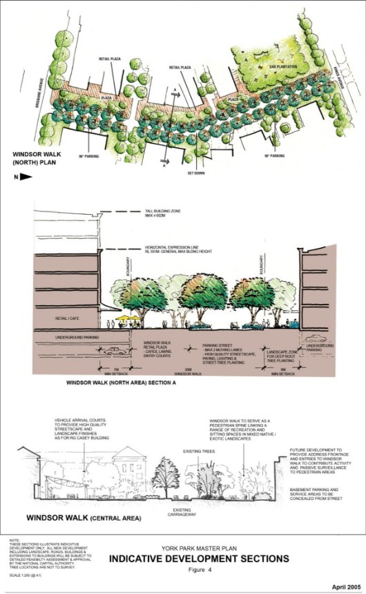
Figure 22: York Park Masterplan – Indicative sections (3)
Other Sites
Block 25 Section 6 Barton
Land use policy
Permitted land uses are:
- Bar
- Café
- Office
- Residential
- Restaurant.
Car parking
Car parking must be provided at the rates specified for Section 9 Barton.
Objective
The objective for Section 10 Barton is to enable the Hotel Kurrajong and its setting to be used as a Hotel and Hotel School without detriment to its heritage values.
Land use policy
Permitted land uses are:
- Hotel
- Educational Establishment
- Open Space.
Block 3 Section 10 Barton is to be retained and maintained as public open space by the lessee, giving special consideration to heritage values of Hotel Kurrajong.
Detailed conditions of planning, design and development
- Landscape and building development works on Section 10 Barton should give special consideration to the heritage values of Hotel Kurrajong.
- Development must address street frontages.
Objective
To allow office development in addition to National Capital Use purposes to enable the York Park precinct to achieve its maximum potential as an office employment area.
Land use policy
Permitted land uses are:
- Diplomatic Mission
- National Capital Use
- Office.
Objective
To allow development for National Capital Use in the southern part of the Block and for purposes consistent with protection of the whole heritage listed York Park North Tree Plantation (commonly known as the Oak Plantation) at the northern end of the block, and to include provision for parking, either in basements and/ or in a parking structure, and ancillary/small scale retail and personal services at building ground level.
Land use policy
Permitted land uses are:
- National Capital Use
- Open Space.
Permitted ancillary uses are:
- Car Park
- Retail (small scale shop), Personal Services Establishment, Café, Bar and Restaurant at building ground level and within a car park structure if provided.
Background
The Riverside site on Section 6 Barton occupies a prestigious position in the Central National Area and is prominent in views from vantage points north of the Lake and on approaches to the Parliamentary Zone. It is critical that the form and scale of development of this key site contributes to Kings Avenue and forms an appropriate built form flanking the Parliamentary Zone. All development in this area of Barton is to be of a consistently high design quality befitting its national significance.
The detailed conditions of planning, design and development for the development of the Section 6 are determined by its:
- prominent location within the Central National Area
- proximity to the Parliamentary Zone and Kings Avenue
- relationship to the Lake and associated parklands
- north sloping terrain which provides panoramic views over the Lake
- visual prominence from vantage points north of the Lake.
The aim is that the Riverside site, together with development on the opposite block, Section 9 Barton, will become an important public precinct with the development of residential and community uses in close proximity to the office employment areas of Barton and Parkes.
Objectives
Encourage high density residential development, together with appropriate forms of commercial accommodation and other minor commercial uses.
Provide residential development that enables people to live close to a major office employment centre and take advantage of the panoramic views that the site affords.
Facilitate the development of small scale commercial land uses, such as commercial accommodation, restaurants, cafés and tourist uses to complement the permitted land uses.
Encourage a diversity of land uses that will enhance the Parliamentary Zone and attract day and night activities into the formal areas of the National Capital.
Land use policy
The permitted land use for Block 22 Section 6 is:
• Residential
Other land uses permitted, ancillary to the above uses, are:
• Commercial Accommodation
• Community Facility
• Recreation
• Retail.
Detailed conditions of planning, design and development
All future buildings on the Riverside site should conform with the following principles:
Building height
A maximum height limit of RL591 has been established for the Barton area including this site. Individual consideration will be given to special vertical elements such as a spire or tower associated with a cathedral building on Block 31 Section 6 Barton.
The height limit establishes a maximum height for commercial buildings flanking Blackall Street with residential, community and other ancillary uses being located in buildings located closer to the Lake, following the sloping terrain of the site and stepping down to three and two levels for the building nearer Bowen Drive.
Built form
The built form should have regard for the site topography, stepping down the slope in terraced levels presenting a series of building ‘fingers’ interspersed with landscaped zones fanning around the contours.
The built form for residential development should be a minimum height of three levels and a maximum of four levels (one being a covered car parking level).
Unbroken, wall like façades will not be permitted. Terraces, balconies, roof decks and awnings are encouraged as a means of modulating façades.
Building setbacks
Buildings should be set back at least six metres from Blackall Street with a 10 metre landscaped setback from Bowen Drive and satisfy the relevant ACT criteria regarding noise standards.
Access and parking
Primary vehicle access is to be from Blackall Street. With the exception of a limited amount of visitor parking, all car parking should be contained in structures (in basements or decked) and screened from external view.
Building materials
Unpainted galvanised metal will not be permitted on roofs, parapets or fascias.
Pedestrian and bicycle movement
A pedestrian pathway/easement through the site is to link Blackall Street to Bowen Drive and the edge of the Lake.
Objectives for Section 9 Barton
Provide for the development of mixed use facilities, including office, retail and residential, incorporating a car parking structure and active street frontages.
Promote a range of land uses including Office, Residential, Retail, Café and Restaurant which contribute to the vibrancy, amenity and convenience of Barton as an attractive place in which to work and live.
Provide a prestigious development reflecting the national significance of Barton in the Central National Area.
Provide a scale of development commensurate with accessibility of the site to nearby infrastructure, cultural attractions and parklands and its location within the Central National Area.
Provide a scale of development that increases private investment in the precinct to deliver public infrastructure including local retail and professional services, café/restaurant establishments, and a parking structure.
Promote environmentally sustainable development including increased pedestrian accessibility and public transport use while reducing dependency on private vehicles.
Land use for Section 9 Barton
Permitted land uses for Section 9 (shown as Land Use A in Figure 18) are:
- Bank and Cooperative Society
- Café, Bar, Restaurant
- Car Park
- Child Care Centre
- Commercial Accommodation (Serviced Apartments only)
- Consulting Rooms
- Office
- Open Space
- Personal Service Establishment
- Residential
- Retail.
Detailed conditions of planning, design and development for Section 9 Barton
Building height
To protect the integrity of views to and from Parliament House, development should be limited to a height of RL591.
Minor building elements (such as lift overruns and roof plant) that extend building height above RL591 will be considered where this enhances the architectural quality of the building, and fosters energy efficiency, indoor amenity, appropriate urban scale, and adds visual interest to the skyline. Minor building elements should be carefully integrated within the form of buildings.
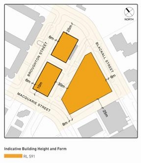
Figure 23: Section 9 Barton – Indicative building height and form
Building form
Building and landscaping will need to exhibit design excellence and be designed to ensure protection of the amenity of surrounding buildings and public spaces, including privacy, overlooking and overshadowing.
Individual buildings are to contribute to the coherent definition of blocks and streets generally in accordance with the layout and setbacks. A hierarchy of public spaces and street frontages should be created, with the greatest amount of public activity and building entrances being encouraged on principal streets and at public spaces.
High standards of architecture are sought for the precinct. Modulation of façades, entrances, window bays, sun shading and balconies, and clear articulation of building elements, textures and materials, should provide interest and variety to the streetscape.
Balconies should be of an appropriate size and design to optimise their use and privacy. A minimum dimension of 2.5 metres for at least one balcony per dwelling should be provided and balustrades should be opaque up to at least four storeys from street level.
Active frontages
Active frontages should include shops and entries to buildings. Address frontages will generally be free of service functions and blank walls, with residential and minor commercial addresses encouraged.
Residential frontages may be set back from street boundaries to provide entry porches and a garden interface with the public domain to protect the amenity of residents and contribute to the interest and landscape qualities of the street.
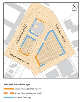
Figure 24: Section 9 Barton – Indicative active frontages
Parking and access
Large off-street permanent surface car parks are to be avoided. Car parking is to be accommodated in basements and/or in above ground structures concealed from public view. Blank façades to public spaces or streets are not permitted and sculptural elements and urban scale public art is encouraged. The inclusion of these elements can assist in ascribing different meanings to buildings, and provides the opportunity to characterise not only shelter and functionality, but to interact with our daily lives.
Some short stay on-street car parking should be provided to support retail uses, pedestrian amenity and after hours activity.
Car parking standards
Car parking for development should accord with the following rates:
- Residential; Commercial Accommodation (Serviced Apartment only):
- 1.5 spaces per 100 square metres of gross floor area.
- Bank; Child Care Centre; Consulting Rooms; Cooperative Society; Office; Personal Service Establishment:
- two spaces per 100 square metres of gross floor area.
- Restaurant, Bar, Café; Retail:
- 2.5 spaces per 100 metres of gross floor area.
A higher on-site and/or off-site parking provision may be required by the National Capital Authority after taking into account the relationship between on-site parking, off-site parking opportunities and the capacity of public transport in the area at the time of development.
The proponent must provide the National Capital Authority a long term parking strategy for construction staging which minimises disruption to parking. The parking strategy must be adopted in the first stage of development to accommodate a minimum of 470 displaced car parking spaces.
Access to the site (for parking and site servicing) should be from the side and access street generally.
Additional parking should be provided for vehicles associated with less consumption of energy. These include bicycles, motorcycles, small cars and car-sharing vehicles.
Car parking structures should provide secure storage and related facilities for bicycle users. This would position the development as a local centre for commuting and recreational cyclists, as well as providing the opportunity for an alternative mode of transport between the many office buildings in the locale.
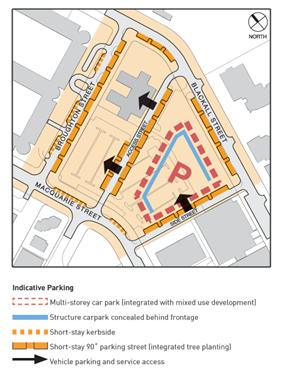
Figure 25: Section 9 Barton – Indicative parking and access
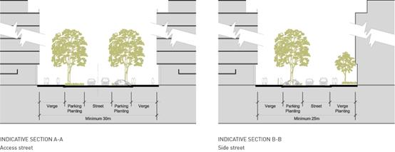
Figure 26: Section 9 Barton – Indicative street sections
Landscape/streetscape
Paving, lighting, street trees and planting beds should be of high quality and should reinforce the amenity and visual quality of the pedestrian environment. Street trees and other large trees are to be planted in deep-root soil conditions. Existing large trees are to be retained (where possible).
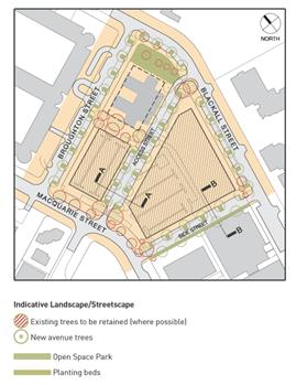
Figure 27: Section 9 Barton – Indicative landscape/streetscape
Public domain and off-site works
A retail plaza is to be provided on the corner of Macquarie Street and the side street (see Figure 28) and furnished with lighting, seating and paving to provide an attractive public area for outdoor cafés and restaurants.
The developer is to carry out off-site works to create a high quality public domain commensurate with a vibrant and attractive mixed use precinct.
On-street parking, verge landscaping, paving, lighting and furniture should be provided using high quality durable materials.
Sustainable development
Development proposals will demonstrate a high level of performance in terms of environmental design including energy efficiency, climate management and water sensitive urban design.
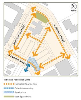
Figure 28: Section 9 Barton – Indicative pedestrian links
Public notification
All applications for Works Approval for major development are subject to public notification and consultation. The determination of those applications that constitute major works is at the discretion of the National Capital Authority.
The Deakin/Forrest Residential Area Precinct comprises the area bounded by State Circle, Canberra Avenue, National Circuit and Adelaide Avenue. The Precinct also encompasses the site of St Andrew’s Church, the Embassy of Italy, Collins Park and diplomatic missions in Red Hill.
Figure 29 illustrates the location of the Deakin/Forrest Residential Area Precinct.
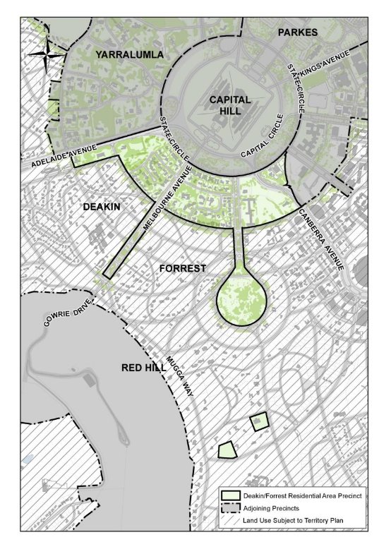
Figure 29: Deakin Forrest Residential Area Precinct location
The importance of the Deakin/Forrest residential area stems from its frontage to the Main Avenue of State Circle, its location within the Griffins’ Land Axis, and from its close proximity and relationship to Parliament House. The residential area is an example of the twentieth century ‘Garden City’ planning concepts that the Griffin’s adopted in their designs for Canberra.
The Deakin/Forrest residential area forms part of the original ‘Blandfordia’ subdivision by the Federal Capital Advisory Committee and the Federal Capital Commission, which was based on ‘Garden City’ and ‘City Beautiful’ concepts.
There is a National Capital interest in ensuring that development surrounding, and in close proximity to, Parliament House is of the highest design quality.
- The residential areas of Deakin and Forrest that lie between State Circle and National Circuit will maintain and enhance the character of the National Capital and will be planned and developed in accordance with its national significance.
- The principle residential character of the area and the use of the land primarily for residential purposes are to continue.
- Design of buildings in proximity to the Prime Minister’s Lodge must reflect the dominant urban design character of the locality.
Land use for the Deakin/Forrest Residential Area Precinct should be in accordance with Figure 30.
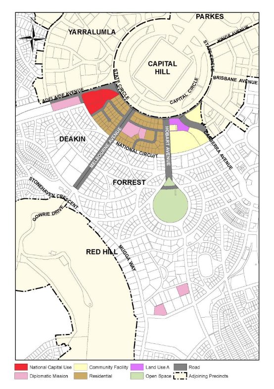
Figure 30: Land use for the Deakin Forrest Residential Precinct
The following uses are permitted on ‘Residential’ blocks:
Commercial accommodation including serviced apartments is not permitted.
Permitted land uses for ‘Land Use A’ are:
- Residential
- Diplomatic Mission
- Commercial Accommodation (Hotel and Serviced Apartment only).
To ensure excellent urban design for this important residential precinct adjacent to Parliament House, the quantitative standards, with the exception of building height and plot ratio, may be varied where it can be demonstrated that this would result in an excellent urban design outcome. All residential development proposals are subject to public notification and consultation with lessees and residents in the Deakin/ Forrest residential area.
The general development conditions include:
- The principal residential character of the area and the use of the land for residential purposes are to continue.
- Development throughout the area, except for sites fronting State Circle, should not be more than two storeys in height and generally no more than eight metres above the natural ground level.
- Development throughout the area, except for sites fronting State Circle, should have a maximum plot ratio of 0.4.
- Design of buildings in proximity to the Prime Minister’s Lodge should reflect the dominant urban design character of the locality.
- Roof mounted aerials, masts and satellite dishes should be located to have a low visual impact.
The following conditions apply to residential sites fronting State Circle between Hobart and Adelaide Avenues.
The objectives of these development conditions are to:
- Provide for high quality residential development of a scale and character appropriate to the setting of Parliament House and the Main Avenue role of State Circle.
- Protect the residential amenity of rear neighbours in terms of privacy, sunlight access and provision of a landscape buffer.
- Reduce traffic access from residences to State Circle.
- Provide for a variety of housing types and sizes.
Block amalgamation may involve more than two blocks.
Any redevelopment of blocks will result in buildings that address State Circle and should be two storeys in height. If blocks are amalgamated three storeys is permissible. If a block is isolated by amalgamation three storeys may be permissible.
The plot ratio for residential redevelopment of existing blocks is 0.4. If sites are amalgamated the plot ratio may be up to 0.8. An exception applies to blocks flanking Melbourne Avenue (Block 1 Section 6 Forrest and Block 9 Section 3 Deakin) which are permitted to develop to a plot ratio of 0.8 without amalgamation. For other blocks, including blocks isolated by amalgamation, a plot ratio higher than 0.4 and up to a maximum of 0.8 may also be permissible (where it can be demonstrated that this would result in an excellent urban design outcome).
Architectural treatment should be of the highest quality, reflecting the prestigious character of the area. The provision of legible entries, accessible from the street, is encouraged as a means of enriching the streetscape. Buildings should be modulated and provided with articulation elements such as porches, balconies, bay window and shade devices, to provide visual interest to the streetscape. Balconies off living areas should generally have a minimum dimension of 2.5 metres.
Due consideration should be given to the roof form and roofscape of buildings. Roof top plant and equipment, if required, should be carefully integrated with the roof form and design of the building and screened from public view from the street. Internal floor to ceiling dimensions should generally be a minimum of 2.7 metres to promote natural lighting and cross-ventilation, consistent with energy efficiency objectives and creation of generously scaled façades.
Vehicle access should be consistent with the principle shown in Figure 31. Blocks, including amalgamated blocks, with a frontage to a road other than State Circle may have access to that road. Site planning should ensure that vehicles are able to enter and leave the site in a forward direction.
The number of vehicular access points to and from State Circle should be minimised in the interests of traffic safety, convenience and streetscape quality.
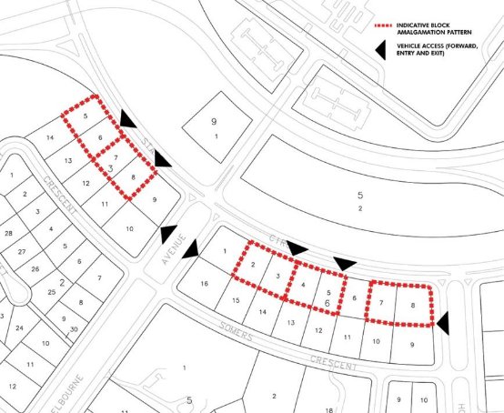
Figure 31: Deakin Forrest Residential Precinct - Indicative block amalgamation and access
Buildings should generally be contained within the building envelopes depicted in Figure 32.
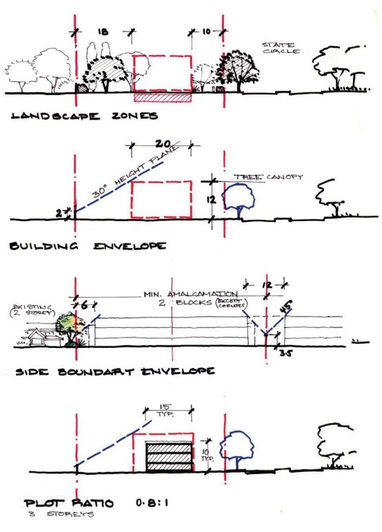
Figure 32: Deakin Forrest Residential Precinct - Building envelopes and setbacks
Setback from State Circle should be 10 metres. Building articulation elements such as balconies, entries and shading devices may be permitted forward of the primary setback.
The minimum setback of buildings from side boundaries for three storey development is six metres. For two storey development, the minimum side boundary set back may be less than six metres provided it is generally in accordance with the building envelope depicted in Figure 32.
The minimum set back for buildings from rear boundaries for three storey development is generally 18 metres. Lower scale development may occur within the rear landscape zone subject to the protection of privacy, the avoidance of overshadowing and the retention of existing substantial trees.
Where the plot ratio exceeds 0.4, car parking other than parking for visitors, should be in a basement. If car parking is in a basement it will not be considered to be part of the Gross Floor Area (GFA) of the building. The basement level is also not considered to be a storey.
The finished floor level of the floor above the basement should not exceed one metre above natural ground level. Vent openings are to be integrated with landscape and architectural elements, and generally concealed from public view.
Undercroft parking, carports, and free standing garages are to be avoided.
The front landscape zone to State Circle should be developed to provide a high quality landscape setting with space for planting medium to large trees.
The rear landscape zone is to provide for a substantial landscape buffer that will afford privacy to rear neighbours and maintain winter sunlight to those properties.
The use of hedges is encouraged in lieu of, or combined with, garden walls when forward of the building line. Any front retaining or garden wall should be integrated with the landscape treatments. Garden walls forward of the building line should generally be transparent in character. The maximum average height of fencing should be 1500mm.
Large expanses of exposed paved surfaces except for necessary vehicle driveways, should be avoided.
Off-site works to be provided by the proponent, may be required as part of the approval for development.
Development of amalgamated blocks is to be guided by the indicative development plan, section and elevation at Figure 33, Figure 34 and Figure 35 respectively.
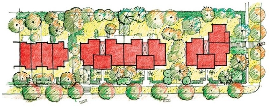
Figure 33: Deakin Forrest Residential Precinct – Indicative development plan for State Circle
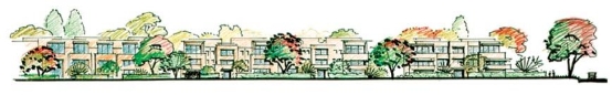
Figure 34: Deakin Forrest Residential Precinct – Indicative elevation for State Circle
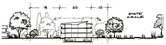
Figure 35: Deakin Forrest Residential Precinct – Indicative cross section for State Circle
Block 10 Section 13 Forrest
The following conditions apply to Block 10 Section 13 Forrest.
The objectives of these development conditions are to:
- Ensure excellent urban design for this important precinct on the final approach to the Parliamentary Zone.
- Provide an opportunity for the development of mixed use facilities, including ‘Residential’, Diplomatic Mission’, and ‘Commercial Accommodation (Hotel and Serviced Apartments only)’.
- Achieve a built form for the Canberra Avenue frontage similar to other sites adjacent to the final approach to the Parliamentary Zone.
- Achieve a built form for the State Circle frontage similar to that of the sites fronting State Circle in the Deakin/Forrest residential area.
Building height
Buildings fronting Canberra Avenue are to be a maximum height of RL594. Buildings fronting State Circle are to be a maximum height of RL591.
Architecture
Architectural treatment must exhibit design excellence, reflecting the prestige of the site location. Buildings must be designed to ensure protection of the amenity of surrounding buildings and public spaces, including privacy and overlooking.
Modulation of facades, sun shading and balconies, and clear articulation of building elements, textures and materials, should be employed to provide interest and variety to the streetscape.
Development must be contained by the Development Zone indicated at Figure 36. Articulation elements permitted in the articulation zone are awnings, shade devices, dwelling entries and roof elements. Balconies are not permitted forward of the primary building setbacks.
Legible entries are to be provided from Canberra Avenue and State Circle. Balconies off living areas should be a minimum dimension of 2.5 metres. Balcony balustrades must be solid to optimise privacy.
Rooftop plant and equipment, if required, should be carefully integrated with the roof form and design of the building and screened from public view from the street and Parliament House. Internal floor to ceiling dimensions should generally be a minimum of 2.7 metres to promote natural lighting and cross-ventilation, consistent with energy efficiency objectives and creation of generously scaled façades. Ground floor level must be equal to or greater than the existing adjacent kerb level.
Setbacks
Buildings should appear as a continuation of existing setback geometries of Canberra Avenue, Hobart Avenue and State Circle. To achieve this, a variable boundary setback to the State Circle frontage is permitted, and in this case setback to road geometry will be given precedence over the setback to the site boundary. Building setbacks from Canberra Avenue and State Circle and rear and side setbacks are indicated in Figure 36.
Access
Vehicular access arrangements will be agreed by the relevant approval authorities, but will reflect the indicative vehicular and pedestrian access in Figure 36.
Vehicular access from Canberra Avenue should provide opportunity for landscape treatments commensurate with the primacy of the location. Access from Canberra Avenue should have minimal impact to the indicative verge planting pattern. The access layout should minimise traffic impact, with site planning to ensure vehicles are able to enter and leave the site in a forward direction.
A vehicular access point from Hobart Avenue should provide for main residential access to parking, visitor access to parking, as well as facilitating all waste and servicing vehicle access. Vehicular access from State Circle is not permitted.
The main pedestrian address frontages for development are to be oriented to Canberra Avenue and State Circle to reinforce the prestige and visual interest of the main avenues. Pedestrian access should connect with existing footpaths.
Car parking
Onsite parking must not be located within the Canberra Avenue and State Circle front landscape zones. All car parking other than parking for visitors, should be in a basement.
Traffic and parking assessments should accompany development proposals for the site, and this will be determined in consultation with the approving authority.
Secure parking entry/exit points should be located to take advantage of the natural fall of the site to avoid external ramps and to maximize the opportunity for ‘at grade’ entry into undercover parking zones under the building footprints.
Parking basements and ventilation openings are to be concealed from public view. Ventilation openings will be configured to minimise light spill and noise from the basements.
Basement car parking within the setback areas on Canberra Avenue and State Circle will only be permitted where it cannot be seen from Canberra Avenue and State Circle and where it does not affect the planting of trees and shrubs.
The visual impact of surface car parking must be minimised through adequate screening and landscape treatment that appropriately considers view lines and safety.
Undercroft parking, carports and free standing garages are not permitted.
Refer to ‘Design and Siting General Code’ for parking provision requirements.
Landscape
Landscaping should be consistent with Figure 36 and employ a formal character to Canberra Avenue and State Circle appropriate to the sites prestigious location.
The front and offsite landscape zones to Canberra Avenue and State Circle must be developed to provide a high quality landscape setting with space for planting shrubs and medium to large trees. The front and offsite landscape zones must be filled to ensure fall away from the ground level of buildings.
The Canberra Avenue verge will have inter-plantings of Eucalyptus mannifera and Prunus species consistent with nearby plantings along Canberra Avenue, and the indicative planting pattern shown in Figure 36. The State Circle verge will have Quercus species plantings consistent with verge trees along State Circle, and the indicative planting pattern shown in Figure 36.
Landscaping should soften built mass presented to Canberra Avenue and State Circle.
Wide building entrances marked with considered landscaping should be used to create formal and legible address frontages to Canberra Avenue and State Circle. These entrances should be integrated with existing footpaths.
A publically accessible, high quality landscaping treatment, reflecting the indigenous landscape character of the land between State Circle and Capital Circle is to be provided at the corner of Canberra Avenue and State Circle to increase the amenity and visual quality for the site.
Letter box pillars, utility meters and minor service structures located in the landscape zone should be harmoniously integrated with the landscape design.
The rear landscape zone is to provide for a substantial landscape buffer that will afford privacy to rear neighbours and maintain winter sunlight to those properties.
Existing trees to the western boundary of Block 10 Section 13 Barton should be maintained where possible to ensure visual privacy between new development and the existing childcare centre. Additional planting to the rear of the site should be used to enhance privacy to the childcare centre without compromising solar gain.
Off-site works
Off-site landscape works, as indicated in Figure 36, consistent with landscaping for the subject site, may be required as part of the approval for development.
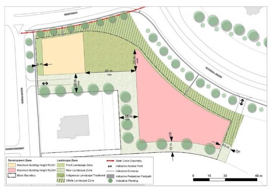
Figure 36: Block 10 Section 13 Forrest - General design principles
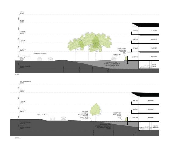
Figure 37: Block 10 Section 13 Forrest - Indicative edge cross sections
City Hill Precinct comprises the area radiating from City Hill and bounded by London Circuit. The precinct includes University Avenue, Ainslie Place and parts of Northbourne, Commonwealth and Constitution Avenues.
Figure 38 illustrates the location of the City Hill Precinct.
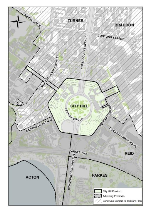
Figure 38: City Hill Precinct location
The City Centre has a multi-faceted role as Canberra’s most important metropolitan centre. The City Hill Precinct within the City Centre is located at the apex of the National Triangle in a location astride an important entrance route to the Parliamentary Zone, and forms a significant element in the physical structure of central Canberra.
City Hill Precinct is the municipal heart of central Canberra. The City Hill Precinct forms the Griffin’s symbolic and geographical centre for the City – a corner completing the National Triangle as a gateway to the Central National Area and a hub connecting significant main avenues and vistas.
There is a National Capital interest in ensuring that:
- Sites within the City Hill Precinct are developed in accordance with their national importance, at the apex of the National Triangle.
- The symbolic importance of the Main Avenues radiating from City Hill (Northbourne, Ainslie, Constitution, Commonwealth, Edinburgh and University Avenues) is protected and supported through the design and development of the adjacent blocks and the landscaping and design of the avenues.
- Maintain and promote the City Centre as the main commercial centre of Canberra and the region – with the City Hill Precinct as the pre-eminent heart of City.
- The design of buildings and the amenity and environmental quality of the main public spaces should result in an accessible, attractive, high quality and distinctive centre, consistent with the City’s role as the major metropolitan centre and its location at one point of the National Triangle, the major organising element of the Central National Area.
- That the City Hill Precinct provides a vibrant, interesting and lively centre with high levels of human activity.
- Development must command the highest standards of urban design, sustainability, exemplary architecture and social inclusion, reflecting the character of the National Capital.
- The City Hill Precinct must complement and actively relate to, and integrate with, the existing and future structure of the rest of City.
- Encourage a mix of land uses, including residential uses, which contribute to a diverse and active character.
- Major buildings of municipal or cultural significance should be located adjacent to City Hill Park, with their main address to Vernon Circle.
Land use for the City Hill Precinct should be in accordance with Figure 39.
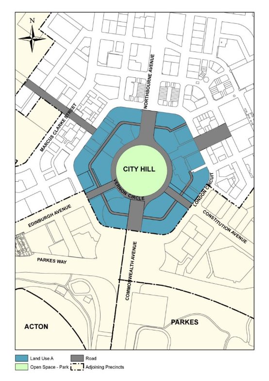
Figure 39: Land use for the City Hill Precinct
Permitted land uses for Land Use A are:
- Administrative Use
- Car Park
- Café, Bar Restaurant
- Casino
- Community Protection Facility
- Cultural Facility
- Diplomatic Mission
- Education Establishment
- Hotel
- Health Centre
- Motel
- Indoor Recreation Facility
- Office
- Park
- Personal Service Establishment
- Place of Assembly
- Public Utility
- Residential
- Retail
- Scientific Research Establishment
- Social/Community facility
- Tourist facility.
Any buildings located within City Hill Precinct must be subsidiary to the permitted use as a park and must be designed, sited and of a scale that complements the landscape character.
New or altered buildings must ensure that:
- Sunlight access to open space within the City Hill Precinct and major pedestrian areas is maintained.
- The vista to City Hill Park is framed and enhanced by new development.
- Predominantly active frontages are provided at ground floor level for building elements fronting London Circuit and the Main Avenues that radiate from City Hill.
Subdivision patterns should be designed to minimise amalgamation of land and achieve a mix of development scales including fine urban grain.
New buildings are encouraged to be delivered through design competitions in order to encourage innovation and design excellence.
The symbolic importance of the City Hill Precinct should be reinforced in the design treatment of the streetscape and public places.
Public art and art spaces in new development should be encouraged.
Landscape and streetscape treatments are to be of a high quality emphasising the geometry and formality of the Main Avenues.
New development should exemplify sustainability principles and demonstrate excellence in urban design, landscape and architecture.
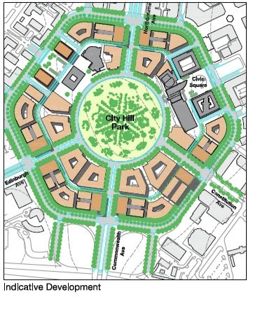
Figure 40: City Hill – Indicative development
City Hill Park should be retained and enhanced as an enclosed central park serving a functional role within an urban built form.
The topography of City Hill Park may need to be modified to create an urban park, accommodate pedestrian desire lines and integrate with Vernon Circle.
City Hill Park is the primary public space for the Precinct. Any buildings located on City Hill Park must be ancillary to this purpose and be designed, sited and of a scale that complements the landscape character.
New public spaces created within the Precinct must complement and not diminish the pre-eminence of City Hill Park.
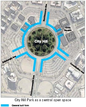
Figure 41: City Hill – City Hill Park as a central open space
Building height
Building heights of up to 25 metres (generally six to eight storeys) above adjacent kerb levels of London Circuit, Vernon Circle and Northbourne, Edinburgh, Constitution and Commonwealth Avenues are permissible in all areas of City Hill Precinct.
Landmark buildings up to RL617 (generally 14 to 18 storeys) will be restricted to the locations identified in Figure 42, generally being the corners of the main avenues intersecting with London Circuit.
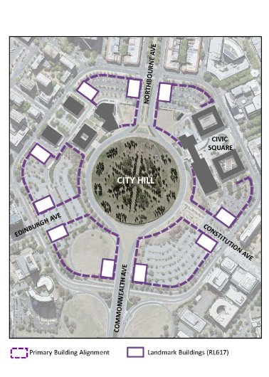
Figure 42: City Hill – Indicative building form, height and landmark buildings
Buildings more than 25 metres in height are to be the subject of wind testing, including down draught conditions and turbulence, to ensure development does not have adverse impacts on building entrances and the public domain.
Buildings fronting Vernon Circle should have a minimum height of 16 metres (equivalent to four storeys) to create a sense of enclosure around City Hill Park.
Minor building elements that extend building height above 25 metres will be considered where this enhances the architectural quality of the building and fosters energy efficiency, indoor amenity and appropriate urban scale.
Minimum floor-to-ceiling heights within buildings are to be as follows:
Location | Min. floor height |
Ground Floor facing Constitution Avenue and roads where ‘Indicative Active Frontages’ are located | 6.5 metres floor to ceiling (mezzanine level permitted over 30% of ground floor) |
Ground Floor (Residential) | 3.3 metres floor-to-ceiling |
Ground Floor (other uses, including commercial/office use) | 3.6 metres floor-to-ceiling |
Residential (general) | 2.7metres floor-to-ceiling minimum for all habitable rooms, 2.4 metres is the preferred minimum for all non-habitable rooms however 2.25 metres is permitted. For two-storey units, 2.4 metres minimum for second storey if 50 percent or more of the apartment has 2.7 metre minimum ceiling heights. For two-storey units with a two-storey void space, 2.4 metre minimum ceiling heights. Attic spaces are permitted, with a 1.5 metre minimum wall height at edge of room with a 30 degree minimum ceiling slope. |
Street level frontages should, where possible, be active. Primary retail activities should be off London Circuit with secondary food and beverage activities occurring along north-south laneways so as to optimise sunlight access during peak periods.
Buildings on the avenues must have predominantly active frontages at ground floor.
New road connections to Vernon Circle from Constitution and Edinburgh Avenues should facilitate access for local traffic and pedestrians.
View corridors must be retained from radiating avenues to City Hill Park. No buildings should bridge these avenues.
A limited palette of high-quality pedestrian pavement materials, street furniture and lighting will be used. Pavement and landscape design should have an elegant, simple and bold design emphasising the geometry and formality of the main avenues.
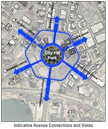
Figure 43: City Hill – Indicative avenue connection and vistas
The heritage values of the Sydney and Melbourne Buildings are to be considered and addressed by new buildings adjacent to these sites.
Major modifications to the existing traffic management arrangements are dependent upon the continuing implementation of peripheral parkways and city bypass routes including Gungahlin Drive, Majura Parkway, Clunies Ross Street, Fairbairn Avenue, Marcus Clarke Street and Cooyong/Ballumbir Streets and the removal of the Parkes Way cloverleaves.
Traffic engineering devices (e.g. slip lanes) should be designed to promote pedestrian amenity, safety and access and bicycle movements.
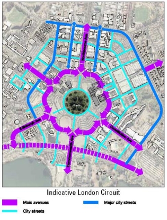
Figure 44: City Hill – Indicative road hierarchy
Replacement of existing surface car parks and public car parking should be provided for as identified in the ACT Government Parking Strategy. Development of existing surface car parks will need to demonstrate that an adequate public car parking provision (on street or in appropriately designed structures) will meet the needs of City Hill Precinct.
Car parking for new development is to be accommodated in basements or in above ground structures that do not dominate the public domain.
London Circuit should operate as the main public transport circuit for Canberra City.
Redevelopment of the City Hill Precinct should take place in the context of an integrated public transport plan. Mechanisms should be introduced to give priority to public transport.
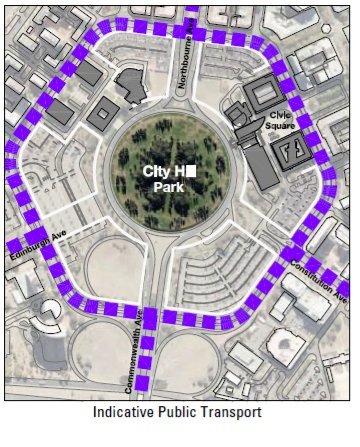
Figure 45: City Hill – Indicative public transport
Existing laneways should be retained and new laneways created to provide permeability and create service access. Opportunities should be identified to create laneways with active frontages, particularly in relation to heritage and public buildings and at intersections.
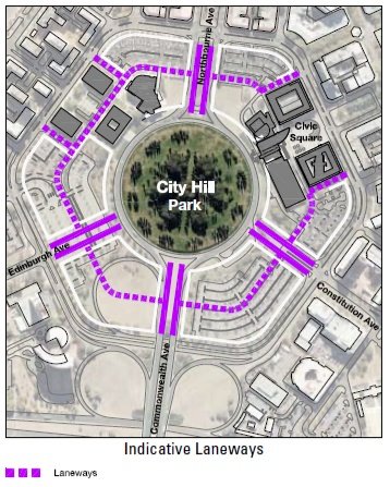
Figure 46: City Hill – Indicative laneways
New development, including public spaces, will facilitate pedestrian connectivity and bicycle movements within the City Hill Precinct and between the City Hill Precinct and Canberra Central.
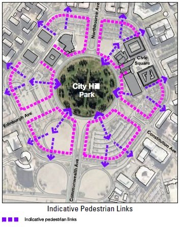
Figure 47: City Hill – Indicative pedestrian links
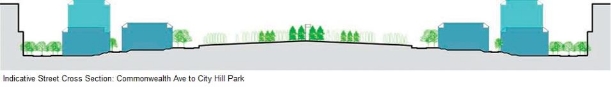
Figure 48: City Hill – Indicative street cross section (Constitution Avenue to City Hill Park)
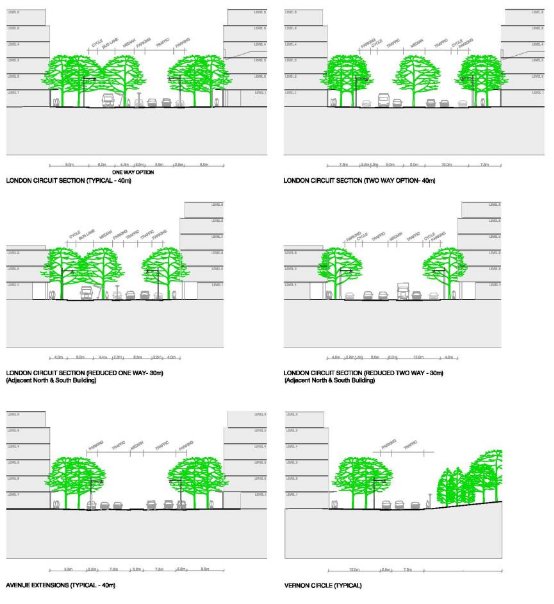
Figure 49: City Hill – Indicative street cross sections
Vernon Circle should serve as a ceremonial road leading to Parliament House and for public events for the city of Canberra. Any major redevelopment of the City Hill precinct should consider alternative options for traffic to allow easy pedestrian access to City Hill via Vernon Circle.
Over time, the existing major cultural and municipal buildings adjacent to City Hill Park (and extensions to them) could be reconfigured to address Vernon Circle.
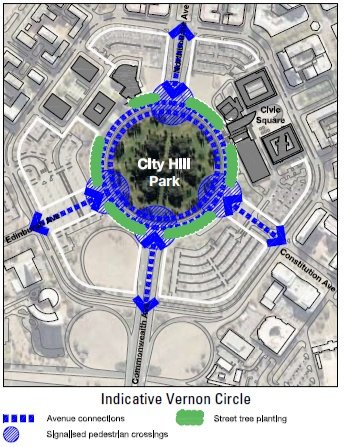
Figure 50: City Hill – Indicative Vernon Circle
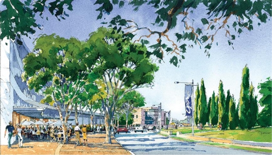
Figure 51: Artist’s impression of Vernon Circle
London Circuit should serve as a gateway, providing a transition between the boulevard character of the avenues and the urban scale of the inner City Hill Precinct. The transition should be achieved through the use of urban design and traffic engineering treatments that serve to physically and psychologically divert traffic from the avenues onto London Circuit, thereby limiting access to the inner City Hill Precinct to predominantly local traffic. London Circuit should operate as the main public transport circuit for Canberra Central.
Buildings must be set back from London Circuit a sufficient distance to establish a tree-lined boulevard character (two rows of trees and wide pavements).
New buildings fronting London Circuit must have active frontages.
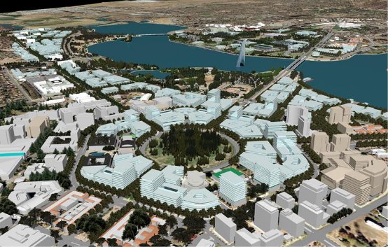
Figure 52: City Hill – Indicative development (an aerial perspective looking northwest towards the National Triangle
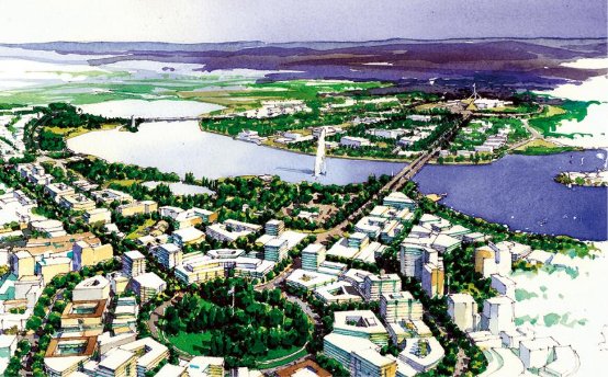
Figure 53: City Hill – An artist’s impression of City Hill Park looking towards the National Triangle