The Authority will assess proposals to ensure they are not inconsistent with the provisions of the National Capital Plan.
(c) Broadacre Areas may act as buffers between towns, provide sites for uses which require large land areas or may benefit from or be best located within a nonurban setting, and provide a land bank for future urban areas.
(d) All proposals for development within 2km of the Bonshaw radio station shall be referred to the Department of Defence for examination and comment and such comment shall be taken into account in arriving at a decision.
(e) Within 5km of Mount Stromlo, development or installations which may, through night time illumination or significant vibration, adversely affect the operation of the Mount Stromlo Observatory or the associated seismological vault at Mount Stromlo, shall be referred to the Australian National University for examination and comment and reasonable steps shall be taken to mitigate adverse impacts.
(f) Pine plantations permitted under 5.2(g) should be retained as multiple use areas. Native vegetation in plantations should be retained, particularly along plantation edges, public roads and rivers and creeks, to preserve wildlife corridors and habitats.
(g) The range of uses permitted in the Broadacre Areas is as follows:
- Administrative and Utility Services
- Agriculture
- Airport (Canberra International Airport only)
- Animal Care Facility
- Caravan Park/Camping Ground
- Community Facility
- Education and Office establishments used by the Department of Defence
- Forestry (Majura and Kowen Pine Plantations only)
- General Farming
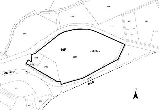
- Industries restricted to the Harman Industrial Area as delineated at Figure 4, Page 228 of the Territory Plan Written Statement (as Gazetted on 14 September 1994), subject to environmental assessment. (As shown below).
- Mobile Home Park (Blocks 6 & 8 Section 97 and Block 17 Section 102 Symonston only).
Harman Industrial Area
- Intensive Farming
- Landscape Buffer
- Open Space
- Outdoor Recreation Facility
- Park
- Retail Plant Nursery
- Scientific Research Establishment
- The Royal Australian Mint on its present site only
- Tourist Facility
- Transport Facility, including Road and Rail
and may include Dwelling if necessary for the operation of any of these uses.
The nature of uses permitted in Broadacre Areas is defined in Appendix A.
In addition, the nature of uses shall be influenced by the following:
1. The Broadacre Areas at the junction of the Barton and Federal Highways and at the Jerrabomberra/Symonston area, are subject to planning studies.
Pending completion of the studies, uses should remain rural in nature, or be of short duration and involve minimal improvements.
2. The Broadacre Area between Curtin and Yarralumla is a buffer area between the towns. The nature of permitted uses in this area will be subordinate to the landscape setting.
3. Within all Broadacre Areas, the land uses will be of a nature that they either require large sites that are not available within urban areas or, for their effective operation, need or would benefit from a non-urban setting.
(h) Canberra International Airport
The range and nature of uses permitted at Canberra International Airport is as follows:
Primary Uses:
- The landing and departure of aircraft
- The housing, servicing, maintenance and repair of aircraft
- The assembly and dispersal of passengers and goods
- Uses determined by the Authority to be associated with and ancillary to and enhance the operation of the airport.
Other Uses:
- The range of uses scheduled at clause 5.2(g)
- Commercial Accommodation
- Dwelling if necessary for the operation of any permitted use
- Light Industry
- Place of Assembly
- Retail, provided that individual retail establishments outside the Terminal Building (other than “Retail” associated with a Primary Use) shall not generally exceed 500 square metres in Gross Floor Area.
Office Use
- Office is a permitted use at Canberra International Airport.
- There is no gross floor area limit for any office use, or for any particular office building, at the Airport where the office use is permitted as ‘Primary Uses’ or ‘Other Uses’.
- The total gross floor area of all offices permitted as ‘Office Use’ shall not exceed 120,000 m2. This gross floor area limit applies to offices which are permitted only as ‘Office Use’. The limit does not include offices which are permitted as ‘Primary Uses’ or ‘Other Uses’.
- Subject to the gross floor area limitation, and subject to any other relevant provisions of the Plan, there is no gross floor area limit on any individual office building at the Airport.
(i) Campbell Park Offices
The range and nature of uses permitted at Campbell Park Offices is:
- Defence Installation
- Office (up to a maximum of 55,000 m2 gross floor area).
5.3 Special Requirements for Broadacre Areas
5.3.1 National Land not included within a Designated Area of this Plan
It is in interests of the National Capital that all National Land achieve a quality of development which reflects Canberra’s significance as the national capital, and that proposals be assessed in relation to the provisions of both the Territory Plan and the National Capital Plan.
Special Requirements
Development, including subdivision and leasing proposals, of all National Land not included in a Designated Area of this Plan, is to conform to Development Control Plans agreed by the Authority. Development Control Plans are to reflect the relevant provisions of the Territory Plan, and meet the following requirements:
(i) Adverse environmental impacts from onsite developments, on adjacent land and development, shall be identified and redressed to the extent practicable.
(ii) Adequate provision should be made where appropriate for visitors to sites.
(iii) Functional relationships between uses within and external to the site shall be provided for.
(iv) Consistency in the external design and site layout of buildings and landscaping shall be sought.
(v) Satisfactory arrangements shall be made for parking accommodation and vehicular access and egress. Traffic impacts of development shall be taken into account.
6. Transport
6.1 Background
The National Capital Plan is required to set out general principles and policies to be implemented throughout the Territory, for planning national and arterial road systems.
The interaction between land use activities and transport is important. The disposition and size of the centres for major employment and other uses places different demands and stresses on the transport system and the physical fabric of the City.
The hierarchical system of roads, developed successfully in the new towns of Canberra, provides a high standard of safety and service to all road users.
The overall transport system comprises the road network, car parking facilities and public transport. The efficiency of the road system depends, not only on the physical provision of infrastructure, but also on the operational policies adopted for the use and control of facilities including public transport.
The main elements of the national and arterial road systems are shown in the General Policy Plan at Figure 1.
The National road system are those roads and highways which support the role of Canberra as the National Capital by:
- providing the principal means of access between the National Capital and the State capitals, and between Canberra and the major national highways
- being designed for symbolic, formal or National Capital purposes
- being roads whose principal purpose is to provide access to National Capital facilities and vantage points within the Territory or, being roads located on land declared as National Land under the Act.
Roads which provide principally for intra and intertown traffic collection and distribution are arterial roads, which in the ACT have been classified under earlier planning policies as parkways (or freeways) and arterial roads. The main elements are shown on the General Policy Plan (Figure 1).
The arterial road system supports the urban structure of Canberra by:
- forming the principal access between town centres, industrial centres, major retail centres and residential areas
- providing access between the separate towns of the urban area.
Standards used in the planning of national and arterial roads should reflect the transport and symbolic functions that they perform and support the urban design, environmental, heritage and land use requirements of the corridor in which they are located.
The National Capital Plan defines the national and arterial road systems within Canberra and the Territory. The effective operation of these systems of roads depends on the planning and design of the total road network.
To ensure the efficiency of the national and arterial road systems, planning and design of all roads should meet nationally recognised practices and standards consistent with the traffic function of the road.
Efficient operation of the national and arterial road systems also requires that an effective public transport and priority system be established. It is important that the provision of public transport and the implementation of related policies by the ACT Government keeps pace with residential, commercial and industrial development needs. These policies should aim to minimise the consumption of energy and to enhance the physical environment of the Territory.
Provision will be made for the Very Fast Train route through the ACT following resolution of land use, transport and environmental concerns. After resolution of those concerns, a specific route would be the subject of an amendment to the National Capital Plan.
The General Policy Plan (Figure 1) identifies some of the arterial roads as “proposed”. Final alignments of these roads are not yet determined. Some flexibility as to the precise alignments shown on this plan for proposed arterial roads must be expected. However, the interpretation placed on the intent of the Plan shall, in each case, be the subject of consultation with the Authority to ensure that detailed proposals are not inconsistent with the Plan.
Some of the proposed roads were the subject of the Gungahlin External Travel Study, initiated by the National Capital Development Commission and completed by the National Capital Planning Authority.
The final resolution of the location, scale and timing of these roads will depend on the outcome of consideration of the proposals by the Commonwealth Joint Parliamentary Committee on the Australian Capital Territory; similar consideration by the ACT Government; and environmental impact assessments. Final roads as approved following these processes will be incorporated in the National Capital Plan at an appropriate future time.
6.2 Principle for Transport
Transport planning and provision will:
- reserve a route for the development of a public transport service to link major employment nodes. As far as practicable the service will be segregated from other transport systems and will operate with priority of right-of-way.
- incorporate nationally recognised practices and standards consistent with the role and function of each road, or additional standards set out for the Designated Areas of this Plan
6.3 Policies and Standards for Transport
(a) The National and Arterial Roads System will:
- generally not provide frontage access to development except where such access will meet appropriate design standards and road safety needs.
- generally intersect with the local road network through distributor roads
(b) A corridor between Civic, the town centres and major employment nodes, suitable for priority or segregated right-of-way for use by public transport services will be reserved against a possible future need to develop a system of inter town and express routes suitable for buses or other technologies as appropriate.
(c) Transport strategies should promote the convenience and efficiency of public transport use.
(d) The final alignment of proposed arterial roads shall be subject to consultation with the Authority and to a determination by the Authority that proposals are not inconsistent with the Plan.
7. Urban Design
7.1 Background
The role of Canberra as the National Capital and its development, since its inception, to an overall design concept, has resulted in an urban environment of a high quality compared with other Australian and overseas Cities.
The quality of appearance that has emerged emphasises and complements Canberra’s natural landscape setting. This character, often referred to as “garden city”, should continue. It is part of the national perception of Canberra, and Canberra’s national image would be impaired if the emphasis on landscape, both within urban and non-urban areas, became diminished. This is particularly important to Canberra Central having regard to its proximity to the main National Capital functions.
Within Canberra’s residential areas there is an emphasis on space for landscape treatment in front of buildings on detached and semidetached housing blocks. This has added to the “garden city” character of the residential streets and is part of Canberra’s national image. The Authority would be very concerned to observe any significant change in these values, and within Designated Areas will ensure that this does not occur. In other areas it is considered that their continuation is properly a matter for the Territory Plan rather than the subject of the National Capital Plan.
7.2 Principles for Urban Design
(1) The National Capital role requires that planning and development in Canberra Central in particular and generally throughout the Territory, should have a high aesthetic and environmental quality. Planning controls should seek to ensure that development in all forms, including landscaping in urban and non-urban areas, complements and enriches its surroundings.
(2) Substantial works of architecture, engineering and landscape within Canberra Central should be designed to contribute positively to the overall composition and symbolism and dignity of the National Capital.
7.3 Policies and Standards for Urban Design
(a) Management of both public and private development in the National Capital should, wherever practicable, seek to achieve harmony between buildings and landscaping to give continuing effect to the garden character of the city.
(b) Within Canberra Central, roads, bridges, waterways and public landscaping projects should reinforce and complement the geometric lines of the Main Avenues.
(c) Buildings in Canberra Central should be of a height generally not greater than the height of the mature tree canopy (typically 3-4 storeys), with the exception of the buildings in the Parliamentary Zone, Civic Centre, Russell and Campbell Park, and on sites adjoining Northbourne Avenue and Constitution Avenue. In Canberra Central no building or structure which protrudes substantially above the tree canopy shall exceed a height of RL 617m.
(d) The siting, bulk, landscaping and external treatment (including materials, colours and the quality of finish) of development in Canberra Central should seek to ensure that buildings, ancillary structures and other works are appropriate to and not discordant with the general development and amenity of the locality.
(e) The Conditions for the Siting of Satellite Dishes and Other Telecommunications Equipment, set out in Part 4 of Appendix H - Design and Siting Conditions, shall have application where relevant within areas to which Special Requirements of the Plan apply.
8. National Capital Open Space System
8.1 Background
The importance of the natural setting of the National Capital has been recognised by the creation and formal adoption of the concept of the National Capital Open Space System (NCOSS). This system essentially comprises the inner hills and ridges which surround and frame the urban areas, the major lakes and river corridors, and the distant mountains and bushlands to the west of the Murrumbidgee River. Closely associated with NCOSS are the Territory’s rural lands which also contribute significantly to the landscape setting.
There are four different types of open space in the NCOSS, each with its own planning and management requirements.
First, there are symbolic spaces that provide the unique and monumental landscapes necessary in a National Capital.
Conservation spaces protect the natural and cultural heritage of the ACT and consist generally of national park, heritage and wilderness areas, and nature parks and reserves.
Living space consists of the network of regional and metropolitan parks which are generally accessible for a broad variety of recreation and tourist uses.
Finally there are linking spaces consisting of fingers of urban land and open space that physically join and visually unite the city and the countryside.
Together these open spaces constitute a system which protects the environmental quality of Canberra’s present and future water catchments, river systems, and important ecological and heritage areas from the increasing pressure of Canberra’s growth. While each part has its own land use and character they are all interrelated as parts of a total system. It is important therefore that the system is planned, developed and managed on an integrated basis.
Mount Stromlo Observatory is within NCOSS. It is a nationally and internationally prominent centre for astronomical research. The amount of night sky light pollution suffered at the observatory impacts on the effectiveness of its operation. Two factors have bearing on this:
- the area of given urban development and its proximity to the observatory
- the nature of the development insofar as it affects the amount of light radiated into the night sky.
The gradual encroachment of urban development into areas previously undeveloped or used for non-urban purposes, has contributed to the deterioration of observing conditions. Because of the observatory’s national significance, a measure of protection is necessary.
The principles and policies that follow establish NCOSS as a multiple use system which protects the environment while providing for the recreational and other needs of the National Capital.
Planning and management for NCOSS in the interests of both the National Capital and Territory residents will require co-operation between Commonwealth and Territory authorities. The National Capital’s requirements will be specified through its detailed land use policies in those parts of NCOSS which are Designated Areas, and through the general policies and special requirements of the National Capital Plan for other NCOSS areas. The Territory will provide for its requirements through the Territory Plan. Management plans, usually prepared by Territory authorities, will be the key to successful implementation of these policies and plans.
Consistency of planning and management and the realisation of an open space system which symbolises the character of the National Capital and provides a unique landscape for the city must be achieved through consultation and by means of joint studies in those areas where both the National Capital Planning Authority and Territory planning authority have a significant interest.
The National Capital Open Space System is incorporated in this Plan under four separate land use categories:
- Lake Burley Griffin (refer 1.2)
- Hills, Ridges and Buffer Spaces
- River Corridors
- Mountains and Bushlands.
Principles and policies for each of these categories are preceded by the following principle and policies for the National Capital Open Space System as a whole.
Protected airspace provisions in relation to Canberra International Airport apply to development independently of the National Capital Plan. To satisfy a requirement of the Airports (Protection of Airspace) Regulations 1996, Canberra International Airport Pty Ltd has prepared a diagram prescribing protected airspace. The diagram is incorporated in the Airport Master Plan prepared under the Airports Act 1996. Detailed information may be obtained from the Commonwealth agency with responsibility for protected airspace (currently Department of Transport and Regional Services)
8.2 Principle for the National Capital Open Space System
The National Capital Open Space System (NCOSS) is required to protect the nationally significant open-space framework, visual backdrop and landscape setting for the National Capital. NCOSS will blend city and country in a way that symbolises the character of the National Capital and provides a balanced range of uses which reinforces the natural, cultural, scenic and recreational values of the ACT.
8.3 Policies for the National Capital Open Space System
(a) NCOSS will be planned as an integrated system so as to protect its environmental qualities, to promote a continuum of natural and park-like settings for the National Capital, and to frame and enhance existing and future urban areas.
(b) The natural and cultural resources of NCOSS shall be protected in order to provide educational, cultural and recreational opportunities.
(c) Public utilities and roads will be located in NCOSS only where technical, environmental and visual assessments clearly demonstrate that the impacts on an area’s conservation and landscape values can be reduced to an acceptable level.
(d) Within 5km of Mount Stromlo, development or installations which may, through night time illumination or significant vibration, adversely affect the operation of the Mount Stromlo Observatory or the associated seismological vault at Mount Stromlo, shall be referred to the Australian National University for examination and comment and reasonable steps shall be taken to mitigate adverse impacts.
(e) As soon as practicable after the coming into operation of this Plan, Management Plans should be prepared for the major NCOSS elements to assist in determining financial responsibilities and as a means of enabling the NCPA to authorise works in Designated Areas. Such Management Plans will be the responsibility of the Commonwealth on National Land and the ACT Government on Territory Land. The ACT Bush Fire Council should be consulted.
(f) Within Designated Areas of the Plan all Management Plans shall be prepared in close consultation with the NCPA. Pending the preparation of the Management Plans, maintenance and other works shall be the subject of liaison with the Authority, and the Authority will identify those works or classes of work which require more formal approval.
(g) Development proposals for National Land, including subdivision, and proposals to lease National Land, shall be referred to the National Capital Planning Authority. The Authority will assess proposals to ensure they are not inconsistent with the provisions of the National Capital Plan.
8.4 Special Requirements for the National Capital Open Space System
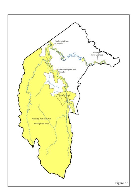
8.4.1 Lanyon Bowl Area (Refer Figure 27)
It is in the interests of the National Capital that nothing shall adversely affect the historic landscape significance and heritage values of the Lanyon Bowl Area.
Special Requirements
(i) The Commonwealth, a Commonwealth authority, the Territory or a Territory authority shall not do anything which adversely affects the historic landscape and heritage values of the Lanyon Bowl Area.
(ii) Proposals to subdivide or lease land and carry out Works within the Lanyon Bowl Area, shall be referred to the Authority. The Authority will assess proposals to ensure that they are not inconsistent with the provisions of the National Capital Plan.
8.4.2 National Land not included within a Designated Area of this plan
It is in the interests of the National Capital that all National Land achieve a quality of development which reflects Canberra’s significance as the national capital, and that proposals be assessed in relation to the provisions of both the Territory Plan and the National Capital Plan.
Special Requirements
Development, including subdivision and leasing proposals, of all National Land not included in a Designated Area of this Plan, is to conform to Development Control Plans agreed by the Authority. Development Control Plans are to reflect the relevant provisions of the Territory Plan, and meet the following requirements:
(i) Adverse environmental impacts from onsite developments, on adjacent land and development, shall be identified and redressed to the extent practicable.
(ii) Adequate provision should be made where appropriate for visitors to sites.
(iii) Functional relationships between uses within and external to the site shall be provided for.
(iv) Consistency in the external design and site layout of buildings and landscaping shall be sought.
(v) Satisfactory arrangements shall be made for parking accommodation and vehicular access and egress. Traffic impacts of development shall be taken into account.
8.5 Hills, Ridges and Buffer Spaces
8.5.1 Background
The hill areas do not attract the same intensity of use as the lakes and rivers of NCOSS but they play a greater role in satisfying the landscape function of NCOSS. It is therefore critical that the hill areas be preserved from urban development and their essential landscape/environmental character retained and reinforced to provide the unified background and landscape setting for the National Capital.
It is not intended that the hills and ridges serve only as public open space. They are intended for multiple-use appropriate to the location and character of each hill area. They will be used as vantage points from which people can view the city and to provide a quiet refuge from urban living. They will also serve as wildlife and access corridors linking urban areas with other parts of the Territory’s open space system. Their continued use for recreation, tourism and appropriate urban services must be in a manner consistent with maintenance of their environmental qualities.
Hills, ridges and buffer spaces around Gungahlin and in other locations will be more precisely defined through the detailed planning of urban development. Before detailed plans are approved by the Territory planning authority certification shall be obtained from the National Capital Planning Authority that the proposals are not inconsistent with the National Capital Plan.
8.5.2 Principles for Hills, Ridges and Buffer Spaces
Hills, ridges and buffer spaces are to remain substantially undeveloped in order to protect the symbolic role and Australian landscape character of the hills and ridges as the scenic backdrop to the Parliamentary Zone, Civic and other National Capital precincts, to maintain the visual definition and physical containment of the surrounding towns and to ensure that their landscape, environmental and recreation values become an integral part of the National Capital.
8.5.3 Policies for Hills, Ridges and Buffer Spaces
(a) The inner hills will be protected as key symbolic and landscape elements in the National Capital Plan expressing the defined land, water and municipal axes and providing the dominant backdrop feature to the city.
(b) The hills and ridges shall be planned and managed as a multiple use recreation and environmental system with different parts having their own special character and use.
(c) The hilltops will continue to be used as key vantage points for viewing and understanding the National Capital. Development will be sited so as to minimise its visual impact on the Central National Area and any environmental impact on the hill tops.
(d) Pine plantations permitted under 8.5.3(h) shall be managed in a manner which reinforces the landscape character and which allows their use as multiple use areas. Native vegetation in plantations should be retained, particularly along plantation edges, public roads and rivers and creeks, to preserve wildlife corridors and habitats.
(e) The environment and Australian landscape character of the hills and ridges will be protected and enhanced to provide a unified landscape setting for the National Capital.
(f) The rural landscape in the areas adjacent to the ACT border between Hall and the Murrumbidgee River and along the Barton Highway will be retained as an intrinsic part of the National Capital character and with additional landscape treatment provide physical containment to this part of Belconnen and a buffer between Belconnen and Gungahlin.
(g) Black Mountain, Mt Taylor, Tuggeranong Hill and Isaacs Ridge will continue to provide locations for current telecommunications facilities. (Refer to Policies for Telecommunications Facilities at 12.4)
(h) The range of uses permitted in the Hills, Ridges and Buffer Spaces part of the National Capital Open Space System will be the following:
- Agriculture
- Extractive Industry (Mugga Quarry only)
- Forestry (Green Hills, Tuggeranong, Ingledene, Stromlo and Fairbairn Pine Plantations and woodlots only)
- General Farming
- Landscape Buffer
- Nature Conservation Area
- Open Space
- Outdoor Education Establishment
- Outdoor Recreation Facility (not including stadiums, showgrounds, racecourses, motor racing and like activities)
- Park
- Pathway Corridor
- Public Utility
- Road
- Scientific Research Establishment
- Tourist Centre (Gold Creek and Gilmore only)
- Overnight Camping (Stromlo Forest Park and Elm Grove campsite only); and
- Tourist Facility (Stromlo Forest Park only)
and may include Dwelling if necessary for the operation of any of these uses.
The nature of uses permitted in the Hills, Ridges and Buffer Spaces part of the National Capital Open Space System are defined in Appendix A.
8.5.4 Special Requirements for Hills Ridges and Buffer Spaces
Special requirements apply to the development of the “Harcourt Hill” resort and to the Gold Creek Tourist Area. These special requirements are set out in Appendix V.
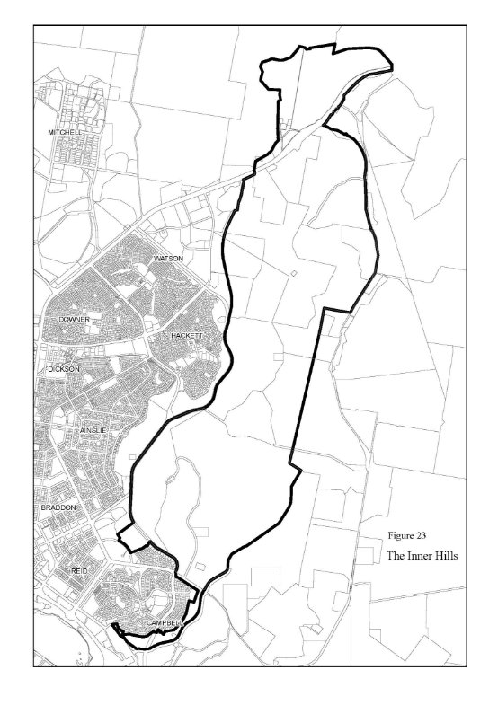
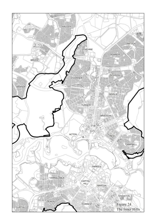
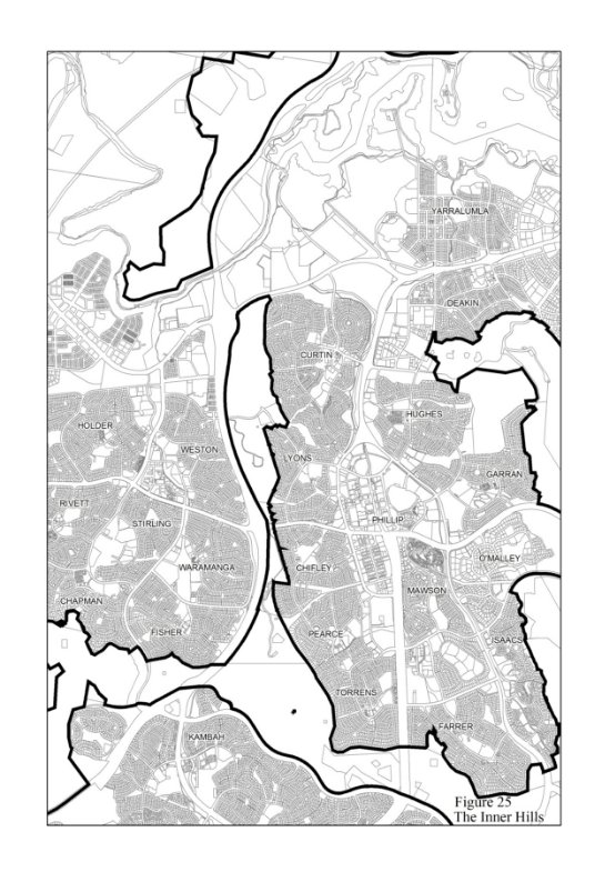
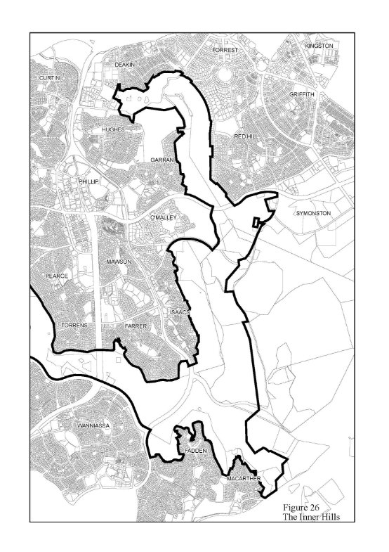
8.5.5 Designated Area “The Inner Hills”
The area identified at Figures 23-26 is specified as a Designated Area under the provisions of Section 10(1) of the ACT (Planning and Land Management) Act 1988 and will be known as the Inner Hills.
The Inner Hills Designated Area includes Black Mountain, Mount Ainslie, Mount Majura, Mount Pleasant, Russell Hill, Red Hill, Mount Mugga, O’Connor Ridge, Bruce Ridge, Mount Painter, The Pinnacle, Lyneham Ridge, Oakey Hill, Mount Taylor, Isaacs Ridge, Mount Stromlo, Mount Arawang, Neighbour Hill, Wanniassa Hill, and Narrabundah Hill.
The Inner Hills provide the scenic backdrop and natural setting for Canberra’s urban areas, and within Canberra Central they are integral to Griffin’s composition. Accordingly their planning, design and development as open space areas are central to the maintenance and enhancement of the character of the National Capital. Designation is the most appropriate way of securing this.
The Design and Siting Conditions at Appendix H apply as Detailed Conditions of Planning, Design and Development within the Inner Hills Designated Area. A further condition is that any proposal to subdivide land within the Inner Hills Designated Area will require the approval of the Authority.
8.6 River Corridors
8.6.1 Background
The corridors of the Murrumbidgee and Molonglo Rivers define zones for which the primary aim is to reinforce and preserve their landscape and heritage values and their ecological continuity, while providing for a balanced range of recreational and tourist related uses.
Established planning and management policies for the Murrumbidgee River Corridor already recognise that recreation is the key land use, and conservation of its natural and cultural values is the primary goal. Detailed policy development of a similar nature is necessary for the Molonglo River (excluding Lake Burley Griffin). This should reflect principles similar to those established for the Murrumbidgee River Corridor, recognising the importance of the Molonglo being a tributary of the Murrumbidgee River and an integral part of NCOSS.
In addition to general principles and policies, the Plan incorporates the provisions of the Murrumbidgee River Corridor Policy Plan as a special requirement guiding development along the Murrumbidgee as it passes through the Territory. The river corridor establishes a definable edge to Canberra’s development, and provides a major recreational resource which, under the terms of the policy plan is also a long-term natural asset of the Capital. Special requirements for the Molonglo River Corridor are also set out.
8.6.2 Principle for River Corridors
To protect and enhance the environmental quality, landscape setting and the natural and cultural resources of the Murrumbidgee and Molonglo River Corridors. The Murrumbidgee River Corridor is to be conserved as an important national resource and a key open space element which provides a definable edge to the developed urban areas.
8.6.3 Policies for River Corridors
(a) Corridors for the major rivers in the ACT will be protected from urban encroachment and inappropriate development. The ecological resources and environmental quality should be conserved and the character of their landscape retained and reinforced.
(b) The streamflow and water quality of the rivers shall be protected from adverse external influences and maintained in a manner which ensures compatibility between land uses, water uses and environmental character of the rivers.
(c) The River Corridors shall primarily provide a balanced range of recreational activities appropriate to the characteristics of the river and adjacent land and in a manner that reinforces and protects them as unified systems.


(d) Built facilities for use of the Murrumbidgee River and Molonglo River Corridors shall provide for access at levels consistent with the protection of their natural and cultural resources, and primarily be located at development nodes identified in appropriate Development Control Plans.
(e) Cultural heritage resources and their landscape context will be protected from inappropriate uses and development. Lanyon shall be maintained as an important cultural resource providing for public access and use consistent with its national significance.
(f) Extraction of sand and gravel may be considered in order to maintain stream channel and flood plain stability or to protect aquatic habitats and recreation areas and to control flooding. Extraction is to be undertaken in a manner consistent with protection of downstream land and water uses and in accordance with the Commonwealth’s Environment Protection (Impact of Proposals) Act 1974 (or equivalent Territory legislation) and with an agreed management and restoration plan.
(g) Development may be limited by constraints related to the Tidbinbilla Deep Space Communication Complex. For details refer to Policies for Rural Areas.
(h) The range of uses permitted in the River Corridors will be the following:
- Agriculture
- Cotter Hotel
- Forestry (Ingledene, Kowen, Stromlo and Uriarra Pine Plantations and Woodlots only)
- General Farming
- Intensive Farming
- Nature Conservation Area
- Park
- Public Utility
- Recreation
- Road
- Special Development
and may include Dwelling if required for the operation of any of these uses.
The nature of uses permitted in the River Corridors part of the National Capital Open Space System are defined in Appendix A.
(i) Development within the Molonglo River Corridor is to comply with all relevant principles and policies of Appendix F and any other relevant principle or policy of the Plan.
8.6.4 Special Requirements for Murrumbidgee and Molonglo River Corridors
It is in the interests of the National Capital to ensure that the Murrumbidgee and Molonglo River Corridors are conserved and managed in accordance with an agreed plan.
The Murrumbidgee and Molonglo River Corridors are shown in the General Policy Plan (Figures 1 & 2) and at Figure 27. The Murrumbidgee River Corridor is defined in greater detail at Appendix F.
Special Requirements
(i) To conserve the natural and cultural resources, and landscape and environmental qualities of the rivers while providing for a balanced range of compatible secondary uses.
(ii) Development within the Murrumbidgee River Corridor shall be in accordance with the general and specific policies set out at Appendix F.
8.7 Mountains and Bushlands
8.7.1 Background
The Bullen Range, together with the mountain ridges of the Tidbinbilla and Brindabella Ranges provide the middle and distant landscape backdrop to the National Capital. A major feature of the Territory is Namadgi National Park. Like Gatineau Park in Ottawa, Canada, Namadgi provides a secure, long-term semiwilderness backdrop to the National Capital, and one which increasingly will become nationally and internationally known as a feature of this city.
Namadgi National Park will continue to be regarded as part of the regional system of alpine parks of south-east Australia and a part of the Australian Alpine National Parks Agreement. Because of its important national role, the Plan provides for its long-term maintenance through incorporation of the Namadgi Policy Plan as a special requirement for the development of that area.
In the Tidbinbilla/Paddy’s River area there are development opportunities which take advantage of its location on Tourist Route 5 and proximity to Canberra. The area’s diverse natural, cultural and rural resources can provide a rich setting for additional tourist uses, and there is scope for the Tidbinbilla Nature Reserve to develop its international potential as a major Australian fauna display on the doorstep of the National Capital.
8.7.2 Principle for Mountains and Bushland
The Mountain and Bushland area is to be maintained as an important visual background to the National Capital; to protect both its nature conservation values and Canberra’s existing and future water supply and to develop appropriate National Capital and tourist uses, particularly in the Tidbinbilla/Paddy’s River area.
8.7.3 Policies for Mountains and Bushland
(a) The water resource, nature conservation, cultural and wilderness values of Namadgi National Park are to be maintained and protected for public appreciation, research, education, natural resource based recreation, and water supply to the National Capital.
(b) The Cotter and Gudgenby catchments should be managed to protect the water supply to the National Capital in a manner consistent with their nature conservation values. The quality of water supp1y in the Cotter catchment is to be assured primarily by controls over catchment uses.
(c) The area comprising Tidbinbilla Nature Reserve, Bullen Range, Paddy’s River, and Gibraltar Creek should be used for appropriate National Capital and tourist uses consistent with protection of the area’s natural, cultural and rural resources. This area should be protected and used as an important transition and open space system linking urban Canberra and the remote mountain and bushland area.
(d) The North Cotter area should be planned and managed in a manner consistent with Namadgi National Park in terms of protection for nature conservation and water supply requirements, with the additional potential of use for low to medium intensity recreation particularly in the pine plantations and adjacent Uriarra rural area.
(e) The Tennant area should be planned and managed to protect its long term use as the location for an additional water supply reservoir for the National Capital. Interim use for rural and nature conservation purposes is to be permitted with steeper slopes progressively revegetated to protect and enhance the area’s future role as a water supply catchment.
(f) Pine plantations permitted under 8.7.3(h) should be retained as multiple purpose areas. Native vegetation in plantations should be retained particularly along plantation edges, public roads and rivers and creeks to preserve wildlife corridors and habitats.
(g) Urban development may be limited by constraints related to the Tidbinbilla Deep Space Communication Complex. For details refer to Policies for Rural Areas.
(h) The range of uses permitted in the Mountains and Bushlands part of the National Capital Open Space System will be the following:
- Agriculture, General Farming, Intensive Farming, (in each case not in Namadgi National Park or the Cotter catchment)
- Educational Establishment (Birrigai)
- Forestry (Pierce’s Creek, Uriarra, Tidbinbilla, Ingledene and Gibraltar Valley pine plantations and woodlots only)
- Nature Conservation Area
- Overnight Camping
- Public Utility
- Recreation
- Road
- Scientific Research Establishment
- Tourist Facility
- Wilderness Area
and may include Dwelling if necessary for the operation of any of these uses.
The nature of uses permitted in the Mountains and Bushlands part of the National Capital Open Space System is defined in Appendix A.
8.7.4 Special Requirements for Namadgi National Park Area
It is in the interests of the National Capital to ensure that the Namadgi National Park Area is conserved and managed in accordance with an agreed plan.
The Namadgi National Park Area is the Namadgi National Park and adjacent areas in the Gudgenby and Cotter Catchments (refer Figure 27).
Special Requirement
Development within the Namadgi National Park and adjacent areas in the Gudgenby and Cotter catchments shall be in accordance with the general and specific policies set out at Appendix G.

9. RURAL AREAS
9.1 Background
Much of the Territory’s rural land has the potential to support agriculture on a long term sustainable basis and this should be supported in leasing and other arrangements. However some provision will be necessary for future National Capital and Territory needs but these should be planned for and located so that rural activities can be continued and the distinctive rural landscape character of each area retained.
These rural lands, and the wider National Capital Open Space System, provide a unique and dramatic setting for Australia’s National Capital, one which increasingly marks this city as internationally distinct and at the same time one of Australia’s most significant achievements.
The ACT contains a number of national communication installations which, to operate efficiently, require protection from the effects of urban settlement and associated development.
The Commonwealth has obligations to protect tracking stations from any electrical or other interference from urban settlement, power transmission lines, radio transmitters or electrical, scientific, medical and industrial equipment. The Tidbinbilla Deep Space Communication Complex will be protected.
Protected airspace provisions in relation to Canberra International Airport apply to development independently of the National Capital Plan. To satisfy a requirement of the Airports (Protection of Airspace) Regulations 1996, Canberra International Airport Pty Ltd has prepared a diagram prescribing protected airspace. The diagram is incorporated in the Airport Master Plan prepared under the Airports Act 1996. Detailed information may be obtained from the Commonwealth agency with responsibility for protected airspace (currently Department of Transport and Regional Services)
9.2 Principle for Rural Areas
The rural areas of the ACT should be retained and utilised on a sustainable yield basis whilst providing a distinctive rural landscape setting for the National Capital.
9.3 Policies for Rural Areas
(a) Land uses or developments should not significantly diminish National Capital landscape values. Rural holdings shall not be subdivided into units which cannot support long term economic farming or agriculture, or which create small units primarily used for residential purposes, except where a Development Control Plan for a clearly defined area identifies smaller holdings and is agreed by the Authority.
(b) On rural lands soils should be conserved and natural tree cover enhanced in order to protect both the resources and the landscape setting of the National Capital.
(c) Pine plantations permitted under 9.3(h) should be retained as multiple purpose areas for other compatible uses, including grazing, recreation, roads and engineering services. Native vegetation in plantations should be retained particularly along plantation edges, public roads and rivers and creeks to preserve wildlife corridors and habitats.
(d) Development proposals for National Land, including subdivision, and proposals to lease National Land, shall be referred to the National Capital Planning Authority. The Authority will assess proposals to ensure they are not inconsistent with the provisions of the National Capital Plan.
(e) Within 5km of Mount Stromlo, development or installations which may, through night time illumination or significant vibration, adversely affect the operation of the Mount Stromlo Observatory or the associated seismological vault at Mount Stromlo, shall be referred to the Australian National University for examination and comment and reasonable steps shall be taken to mitigate adverse impacts.
(f) The Tidbinbilla Deep Space Communication Complex is located within a Rural Area of the ACT.
Urban development near Tidbinbilla Deep Space Communication Complex is limited by the following zone constraints (refer Figure 28)
- Zone ‘A’ — no development is permitted within a 1.25 km radius from the centre of the complex
- Zone ‘B’ — no industrial development is permitted within a 3 km radius of the centre
- Zone ‘C’ — an arc from the northwest to the southwest which is modified by the terrain.
(g) The range of uses permitted in Rural Areas will be the following:
- Agriculture
- Forestry (Kowen and Pierces Creek pine plantations only)
- General Farming
- Intensive Farming
- Landscape Buffer
- Outdoor Recreation Facility (not including sportsgrounds, stadiums, showgrounds, racecourses, motor racing and like activities)
- Overnight Camping
- Park
- Public Utility
- Road
- Scientific Research Establishment
and may include Dwelling if necessary for the operation of any of these uses.
The nature of uses permitted in Rural Areas is defined at Appendix A.
9.4 Special Requirements for Rural Areas
9.4.1 Tidbinbilla Deep Space Communication Complex
(Refer Figure 20)
It is in the interests of the National Capital that any further development of the Tidbinbilla Deep Space Communications site is sympathetic to the rural landscape character of the surrounds.
Special Requirement
Development is to conform to a Development Control Plan agreed by the Authority.
9.4.2 Lanyon Bowl Area (Refer Figure 27)
It is in the interests of the National Capital that nothing shall adversely affect the historic landscape significance and heritage values of the Lanyon Bowl Area.
Special Requirements
(i) The Commonwealth, a Commonwealth authority, the Territory or a Territory authority shall not do anything which adversely affects the historic landscape and heritage values of the Lanyon Bowl Area.
(ii) Proposals to subdivide or lease land and carry out Works within the Lanyon Bowl Area, shall be referred to the Authority. The Authority will assess proposals to ensure that they are not inconsistent with the provisions of the National Capital Plan.
9.4.3 National Land not included within a Designated Area of this Plan
It is in the interests of the National Capital that all National Land achieve a quality of development which reflects Canberra’s significance as the national capital, and that proposals be assessed in relation to the provisions of both the Territory Plan and the National Capital Plan.
Special Requirements
Development, including subdivision and leasing proposals, of all National Land not included in a Designated Area of this Plan, is to conform to Development Control Plans agreed by the Authority. Development Control Plans are to reflect the relevant provisions of the Territory Plan, and meet the following requirements:
(i) Adverse environmental impacts from on-site developments, on adjacent land and development, shall be identified and redressed to the extent practicable.
(ii) Adequate provision should be made where appropriate for visitors to sites.
(iii) Functional relationships between uses within and external to the site shall be provided for.
(iv) Consistency in the external design and site layout of buildings and landscaping shall be sought.
(v) Satisfactory arrangements shall be made for parking accommodation and vehicular access and egress. Traffic impacts of development shall be taken into account.
10. Heritage
10.1 Background
The Commonwealth and the ACT Governments both have a continuing interest in protecting heritage sites in the ACT. In the Commonwealth sphere, the Australian Heritage Commission maintains the Register of the National Estate which includes places of aesthetic, historic, scientific or social significance or other special value, being components of the natural or cultural environment.
It is considered necessary that the Commonwealth and ACT Governments should, as a matter of course, respect each other’s register. In any case, where either wishes to depart from the other’s register, any differences should be subject to consultation between the two and with the public.
10.2 Principle for Heritage
The Territory’s natural and cultural heritage should be identified, preserved, protected and conserved in accordance with internationally accepted principles, and in order to enhance the character of Canberra and the Territory as the National Capital.
10.3 Policies for Heritage
(a) Planning and development should give due protection to any natural or cultural heritage place in the ACT included on the Register of the National Estate and/or heritage register of the ACT Government.
(b) Within Designated Areas the Authority will require Conservation Plans for listed heritage places. The Conservation Plans for cultural heritage sites will follow the principles of the Australia ICOMOS Guidelines for the Conservation of Places of Cultural Significance (Burra Charter).
(c) Planning policies and the applicable development conditions should conform with the requirements of any such Conservation Plan.
11. Environment
11.1 Background
Previous planning and development of Canberra and the ACT has provided for growth of the National Capital while maintaining a distinctive environmental setting and protecting key national and cultural resources for future generations to enjoy. The challenge facing the ACT is that of maintaining and enhancing its environmental qualities under the pressures of population growth and associated urban development.
Long term metropolitan planning must incorporate recognised guidelines and goals for water quality (particularly in the built environment) and reflect national and international concerns for efficient use of energy and effective responses on the Greenhouse effect. Use of national resources and the impact of development on environmental systems in both the ACT and the surrounding region must reflect national goals for sustainable development and regional needs.
Meeting these challenges in a manner which maintains a proper balance between conservation of the environment and development of the city will require a greater focus on the integration of environmental parameters with the economic, social and other forces shaping the National Capital.
11.2 Principle for Environment
The environmental quality of the National Capital and the Territory should be maintained and improved.
11.3 Policies and Standards for Environment
(a) Action will be taken by the Authority in accordance with the Environment Protection (Impact of Proposals) Act 1974 where the scale or nature of a development proposal under its jurisdiction is likely to have a significant impact on the environment of the ACT and the adjoining region.
(b) Nationally recognised guidelines and standards will be the minimum basis for assessing environmental quality in relation to the Authority’s policies and in the approval of projects by the Authority.
(c) The ecological resources of the ACT shall be planned and managed in an integrated manner to maintain or enhance the overall quality and stability of the environment of the National Capital, having regard to such issues as soil conservation, nutrient recycling, water balance regulation, salinity control and protection of water quality.
(d) As wide a range as possible of the naturally occurring plant and animal communities and species of the ACT should be protected in situations where their long-term survival can be expected and the propagation of rare or vulnerable species in suitable protected habitats will be encouraged.
12. Infrastructure
12.1 Background
Infrastructure requirements include water treatment, water supply and reticulation, sewage treatment and dispersal, stormwater control, solid waste disposal, and electricity, gas and communications installations, facilities and services. The Authority is seeking to ensure that, in the provision of these basic services in the ACT, the orderly development of the National Capital is assured and the visual and physical environments are protected and in particular that the provision of infrastructure should keep pace with residential and other development. It is critical that water over which the Commonwealth has paramount rights should be allocated, as a matter of priority, to serve the needs of the National Capital.
12.2 Principle for Infrastructure
The public infrastructure of Canberra and the Territory shall be planned and provided in an integrated and timely manner to facilitate the continued development of the National Capital and ensure safety and security of supply and operation.
12.3 Policies for Infrastructure
(a) Existing and proposed water catchment areas should be protected from development and other activities likely to adversely affect water quality, to ensure the safe supply of high quality water to the National Capital.
(b) Storm water and sewage treatment facilities should minimise the effects of stormwater runoff and wastewater on the lake and river systems of the ACT and in particular the Murrumbidgee River.
(c) The planning and provision of electricity and telecommunications facilities should be undertaken in a manner which takes all reasonable steps to minimise the visual effects of transmission lines, substations and telecommunications facilities on the natural and built environments of the National Capital. Detailed policies for the installation of telecommunications facilities are set out at 12.4.
(d) Subject to any future Commonwealth Government policy decisions on the matter, waters over which the Commonwealth has paramount rights shall be supplied only to users within the ACT and the presently gazetted area of Queanbeyan.
(f) Public utilities infrastructure and facilities for Commonwealth needs and activities, including those on National Land, shall be established and maintained at adequate capacity.
12.4 Policies for Telecommunications Facilities
These Policies apply to the installation and erection of telecommunications facilities, being facilities subject to the Telecommunications Act 1997.
Items subject to these policies
The following items are subject to the Policies for Telecommunications Facilities:
- ground based towers, antenna masts and headframes;
- underground and aerial cabling;
- rooftop antennas, headframes and associated structures;
- microwave or satellite antennas or dishes (this includes both ground and rooftop mounted installations); and
- any equipment structures (buildings and fenced enclosures) associated with the above.
Network Master Plans
The development of network master plans in newly developing areas and established areas where no telecommunications networks exist would facilitate the process of considering and approving new facilities. Accordingly, carriers are encouraged to prepare and maintain a Network Master Plan for their existing and proposed operations (including cable rollout) in the ACT.
It is envisaged that Network Master Plans will identify existing and proposed sites and indicate the type, height and function and EME levels of the principal elements of the planned network.
Carriers should consult with the relevant authority to agree to the content of the Network Master Plan and to agree to the process for any community consultation.
General and Specific Policies
The Policies for Telecommunications Facilities consist of General Policies and Specific Policies.
General Policies are broadly based and define the key objectives and general policies for the design and siting of telecommunications infrastructure throughout the ACT. Carriers, service providers and individuals will need to take account of the General Policies when installing facilities within the ACT. Proponents of Low-impact Facilities exempt from formal approval are required to consult with the National Capital Authority prior to carrying out works to ensure that the provisions of the General Policies are satisfied.
Specific Policies define the conditions and standards for the siting of telecommunications infrastructure within Designated Areas and on land adjacent to specified Main Avenues.
Objectives
The objectives of the General and Specific Policies are:
(i) To ensure that the operation of a functional telecommunications service meets community expectations and does not adversely affect the character of Canberra as the National Capital, including the landscape setting of the city and the national significance of land specified in this Plan as Designated Areas.
(ii) To minimise environmental and visual impacts arising from the construction, operation, maintenance, decommissioning and removal, and site rehabilitation of telecommunications infrastructure.
12.4.1 General policies
(a) Erection of Telecommunications Structures
Choice of site
(i) Sites where a tower, mast or antenna will be visually incongruous should be avoided wherever possible. Where a choice of site exists, low rise, small scale residential areas should be avoided and commercial, industrial or transport related land with existing utility structures such as lighting columns or other vertical structures should be selected. Where practicable, sites having environmental, nature conservation or heritage significance, and sites of community concern such as schools, childcare centres or where a facility may interfere with existing emergency or safety equipment, should be avoided.
Choice of antenna location and mast sharing
(ii) The mounting of antennas on a building or an existing mast is the preferred way of accommodating a new facility. Where there are several antenna mounting and locational options, care is to be taken to choose the most appropriate option that has the least visual impact on the community and surrounds.
Electromagnetic Energy (EME) Standard
(iii) The current Australian Standard AS2772.1 for Electromagnetic Energy applies to all proposals.
Ameliorative Actions
(iv) Wherever possible, sites should be either screened from the most prominent views or have a backdrop of trees, buildings or high ground. Ideally sites should have both a well-screened foreground and background keeping to a minimum the height of mast and antenna exposed to view. Where parts of an antenna or mast are exposed, they are to be finished in a colour that is not highly reflective and that minimises their intrusiveness.
Decommissioning and Restoration
(v) When a facility is no longer required, or is to be superseded by a replacement facility, the facility is to be removed from a site within a period of three (3) months and the site is to be left in a condition consistent with the surrounding land.
(b) Rollout of Cable
Method of rollout dependent on site sensitivity
(i) For any proposal to rollout telecommunications cable, the method of rollout should be considered in relation to the sensitivity of the site. For areas of high sensitivity, such as Designated Areas, urban parks and new subdivisions, underground cabling is the preferred method.
Co-location to minimise impacts
(ii) For any proposal to rollout telecommunications cables in areas where an existing public utility is in place, the method of rollout should be considered in relation to the existing utility infrastructure. In new subdivisions, or areas where underground infrastructure already exists, the rollout of telecommunications cable should be co-located with existing cable or undertaken in a similar manner.
Avoiding duplication
(iii) As far as practicable and where the technology permits, cable rollout should be carried out in a coordinated fashion to avoid duplication. A proliferation of overhead telecommunications cables should be avoided in situations where a single cable is capable of delivering the proposed telecommunications service. In cases where more than one cable is proposed, carriers should demonstrate that the use of a single cable is not practical for technical, environmental or economic reasons.
12.4.2 Specific Policies
(a) Policies within Designated Areas
Large scale facilities
(i) Large-scale facilities, such as towers and masts will only be approved where no other alternative exists and where the proposal does not create any significant disruption to the visual environment.
(ii) No additional towers and masts will be approved on Red Hill, Mount Mugga, Black Mountain, Isaacs Ridge, Mount Pleasant or Mount Ainslie which:
- break the natural skyline
- significantly impact on the side slopes.
(This does not preclude the use of existing masts and towers subject to a detailed assessment of the impact of any additional antennas.)
Ground level facilities
(iii) Ground level facilities such as equipment shelters and electrical equipment boxes are to be located in the least conspicuous position and are to be suitably screened from public view. Such facilities will generally not be permitted in front of buildings.
Satellite and Microwave Dishes
(iv) Rooftop mounted dishes will be considered only where it can be demonstrated that a ground level location is not available or is technically unsuitable. In considering roof mounted facilities, any impact on the following shall be avoided:
- active pedestrian streets and urban spaces
- key public spaces
- building frontages
- heritage buildings.
Roof mounted facilities
(v) Roof mounted facilities should, as far as practical, be incorporated within, or integrated with, structures on the roof in a purpose designed roofscape. Where no other structure exists above the roof line, and it is practical to do so, the proposed facility should be set back from the parapet line of the building or integrated into the building design to minimise the visual impact.
Cable Rollout
(vi) Approval within Designated Areas for overhead cable rollout will only be given where overhead services already exist and where the National Capital Authority is of the opinion that the proposed cable will not impact adversely on the locality.
Procedure
(vii) In Designated Areas, the National Capital Authority may withhold approval in any particular case where it is of the opinion that the proposed facility would impact adversely on the appearance of the building and locality to an unacceptable degree.
(viii) The current Australian Standard AS2772.1 for Electromagnetic Energy (EME) will be used as the basis of determining acceptable energy emissions. All proposals must meet the Australian Standard for EME.
(ix) Applicants should seek any required clearances for access and development prior to an application being submitted to the National Capital Authority. It should be noted that the Conservator of Flora and Fauna is responsible for approving licences over land identified in the Territory Plan as Public Land.
(x) Carriers are required to:
- maintain network master plans showing the principal existing and proposed elements of their planned network relating to Designated Areas, and
- make such network master plans available to support individual applications if and as requested by the National Capital Authority.
Community Consultation
(xi) Public notification may be required by the National Capital Authority where it is of the opinion that facilities within Designated Areas will create a high visual impact. Facilities defined as Low-impact Facilities in the Telecommunications Act 1997 are not subject to public notification.
Where public notification of a proposal is required by the National Capital Authority, the applicant will advertise the proposal in the principal newspaper circulating in the locality. The advertisement (the content of which must be agreed to by the National Capital Authority) will invite interested parties to submit written comments to the National Capital Authority. The period within which submissions may be lodged will be specified and will be not less than 14 days from the date of the advertisement. Any comments received by the National Capital Authority will be provided to carriers for their response and will be used in the final assessment of the proposal.
Information Requirements for Applications to the National Capital Authority
(xii) The detail and level of information required should reflect the specific nature of each proposal, its context and its likely impact. Accordingly, the emphasis and detail will be much less for Low-impact Facilities. Applicants are encouraged to consult with the National Capital Authority before a proposal is submitted to better determine the extent of detail required for each proposal. The following information will be required for applications to the National Capital Authority:
- A description of the proposal and location of the proposed activity, including the purpose and need for the facility, design drawings (plan and elevation) of the facility including antenna(s), towers and ground installation, and the description of material and finishes.
- A description of any visual impacts from the proposal, including design and siting factors, the extent and nature of visual impact, and the scale of the impact.
- Details of any electromagnetic emission levels.
- A description of any environmental impacts arising from the construction and maintenance of the facility, including any impacts concerning flora and fauna, noise, health, electronic interference on community infrastructure such as emergency and safety equipment, erosion and run-off control, construction of access and power supply, and heritage and archaeological aspects.
- Evidence that a range of sites has been investigated and that the site and type of installation is the least visually obtrusive within technical operational requirements. Separate evidence from an independent source, may be required where the National Capital Authority is concerned about the visual or environmental impact of a proposal.
- A description of any mitigation measures (safeguards and contingency plans where relevant) to be undertaken to help prevent or reduce the actual or potential impacts.
- An indication that the land lessee has been advised of the proposed activity.
- Network master plans referred to in (x) above or a statement of compliance with a previously submitted network master plan, as requested.
(b) Policies for land adjacent to specified Main Avenues
The following policies are specific to the installation of facilities on land immediately adjacent to specified Main Avenues being:
- Northbourne Avenue, between Antill Street/Mouat Street and London Circuit
- Adelaide Avenue, outside the Central National Area
- Canberra Avenue, outside the Central National Area including the section of Canberra Avenue between Hume Circle and the ACT border that is defined at 2.1 as an Approach Route
- Wentworth Avenue, from Hume Circle to Brisbane Avenue
- Brisbane Avenue, outside the Central National Area
- Constitution Avenue outside the Central National Area.
(i) The installation of facilities, including Low-impact Facilities and satellite dishes, on buildings and structures on land immediately adjacent to Specified Main Avenues, should be undertaken in accordance with the following standards:
- the facility is to be positioned to reduce the visual impact of the facility when viewed from street level and nearby vista points;
- roof mounted facilities are to be incorporated within, or integrated with, structures on the roof in a purpose designed roof scape. Where no other structure exists above the roof line, the proposed facility is to be set back from the parapet line of the building or integrated into the building design to minimise the visual impact; and
- if visible from the Main Avenue, the facility is to be colour matched with the surrounding finish of the building or structure to which the facility is attached.
(ii) If it is impracticable to fully comply with the above standards, carriers and service providers must consult with the National Capital Authority to determine the best method to ensure reasonable compliance.
PART TWO Administration and Implementation
Effect of the Approved Plan
This plan takes effect on publication of the notice of approval in the Commonwealth Gazette by the Commonwealth Minister for the Arts, Tourism and Territories.
Upon such notice Section 11 of the Australian Capital Territory (Planning and Land Management) Act 1988 takes effect. Section 11(2) of the Act states that “the Commonwealth, a Commonwealth Authority, the Territory or a Territory Authority shall not do any act that is inconsistent with the Plan.”
Following approval of the Plan by the Minister any works in Designated Areas are to be subject to the Plan and to the approval of the National Capital Planning Authority. The Act defines works as including:
(a) the construction, alteration or extension of buildings or structures;
(b) landscaping;
(c) tree-felling; or
(d) excavations;
but excludes anything done inside buildings or structures.”
Relationship to the Territory Plan
The Act requires the ACT Legislative Assembly to make laws to establish a Territory planning authority and confer functions on that authority to prepare and administer a plan in respect of all land other than Designated Areas, in a manner not inconsistent with the National Capital Plan.
The Territory planning authority will therefore be responsible for approving development in all areas of the Territory other than Designated Areas. In the case of areas where special requirements have been set out in the National Capital Plan, the Territory planning authority will be responsible for approving development providing that the proposal is not inconsistent with the requirements as specified in the Plan.
The National Capital Plan therefore provides a framework within which the Territory Plan can be prepared. Section 25(2) of the Act states that the object of the Territory Plan is
“to ensure, in a manner not inconsistent with the National Capital Plan, the planning of the Territory to provide the people of the Territory with an attractive, safe and efficient environment in which to live work and have their recreation.”
The National Capital Plan has set out the general policies of land use and the planning of national and arterial road systems, to be implemented throughout the Territory. The Territory Plan will provide more detailed planning controls within the context of these general policies.
Development and Management of National Land
Section 27(1) of the Act provides that the Minister may, by notice published in the Commonwealth Gazette, declare specified areas in the Territory to be National Land. However the Minister shall not declare an area to be National Land unless the land is, or is intended to be, used by or on behalf of the Commonwealth [Section 27(2)].
The Act provides at Section 11(2) that
“The Commonwealth, a Commonwealth authority, the Territory or a Territory authority shall not do any act that is inconsistent with the Plan.”
Except within Designated Areas and areas subject to Special Requirements, the National Capital Plan is necessarily general and provides little effective control over the Commonwealth’s operations.
Given the significant presence of Commonwealth Departments and authorities in the Territory and the extent of their National Land holdings, it is appropriate that procedures be established to assess Commonwealth development proposals and that the provisions of both the National Capital and Territory Plans be observed. Accordingly the National Capital Plan:
- includes large National Land sites within Designated Areas where it is considered that they have the special characteristics of the National Capital to satisfy the requirements of Section 10(1) of the Act
- contains Special Requirements for Development Control Plans to be prepared and agreed by the Authority in respect of the remaining National Land sites which are not included within Designated Areas. Amongst other requirements, the Development Control Plans are to reflect relevant provisions of the Territory Plan
- requires that proposals to develop, subdivide or lease National Land shall be referred to the Authority who will assess consistency with the provisions of the National Capital Plan.
Review Process for Aspects of the Plan
The approved Plan should not be regarded as a one-off end state, static document. The Plan should be seen as the first National Capital Plan and as the start of a dynamic and evolving process. Section 6(b) of the Act requires the Authority
“to keep the Plan under constant review and to propose amendments to it when necessary.”
The process of amendment as stipulated in the Act follows the same process as set out for the Plan itself. Consequently any proposed amendment is in the first case to be released as a draft for public comment, and also to be referred to the Territory planning authority for consultation.
The draft amendment is ultimately to be referred to the Minister for approval, together with a written report on the consultations that have been carried out. Following Ministerial approval, the amendment has effect when the notice of approval is published in the Commonwealth Gazette. Parliament may subsequently disallow all or part of the amendments.
