Schedule 1 Outer limits of parts of continental shelf
(sections 5 and 6)
Part 1 Lord Howe Island and Norfolk Island
The line commencing at the point of latitude 26 06 10.91 south, longitude 173 23 53.59 east and running:
(a) south-westerly along the geodesic to the point of latitude 27 05 37.98 south, longitude 171 54 30.61 east; and
(b) then southerly along the geodesic to the point of latitude 27 29 53.98 south, longitude 171 58 42.98 east; and
(c) then southerly along the geodesic to the point of latitude 27 52 50.38 south, longitude 171 58 51.31 east; and
(d) then southerly along the geodesic to the point of latitude 28 13 20.83 south, longitude 171 56 10.22 east; and
(e) then southerly along the geodesic to the point of latitude 28 52 49.54 south, longitude 171 56 16.16 east; and
(f) then southerly along the geodesic to the point of latitude 30 25 42.70 south, longitude 171 56 30.44 east; and
(g) then south-westerly along the geodesic to the point of latitude 30 43 29.25 south, longitude 171 28 45.57 east; and
(h) then south-westerly along the geodesic to the point of latitude 30 53 11.23 south, longitude 171 13 28.85 east; and
(i) then south-westerly along the geodesic to the point of latitude 31 16 01.68 south, longitude 170 37 06.34 east; and
(j) then south-westerly along the geodesic to the point of latitude 31 19 31.67 south, longitude 170 31 15.10 east; and
(k) then south-westerly along the geodesic to the point of latitude 31 40 26.30 south, longitude 169 56 12.27 east; and
(l) then south-westerly along the geodesic to the point of latitude 31 47 23.99 south, longitude 169 44 25.06 east; and
(m) then south-westerly along the geodesic to the point of latitude 32 04 50.57 south, longitude 169 14 37.00 east; and
(n) then south-westerly along the geodesic to the point of latitude 32 06 52.74 south, longitude 169 11 06.79 east; and
(o) then south-westerly along the geodesic to the point of latitude 32 25 18.55 south, longitude 168 39 03.72 east; and
(p) then clockwise westerly along the geodesic arc of radius 200 nautical miles concave to Norfolk Island to the point of latitude 32 22 18.95 south, longitude 166 58 54.37 east; and
(q) then clockwise westerly along the geodesic arc of radius 200 nautical miles concave to Norfolk Island to the point of latitude 32 09 22.23 south, longitude 166 17 34.30 east; and
(r) then clockwise north-westerly along the geodesic arc of radius 200 nautical miles concave to Norfolk Island to the point of latitude 31 53 49.17 south, longitude 165 46 20.73 east; and
(s) then clockwise north-westerly along the geodesic arc of radius 200 nautical miles concave to Norfolk Island to the point of latitude 31 30 south, longitude 165 13 27.08 east; and
(t) then south-westerly along the geodesic to the point of latitude 32 30 south, longitude 163 06 58.81 east; and
(u) then clockwise southerly along the geodesic arc of radius 200 nautical miles concave to Lord Howe Island to the point of latitude 33 52 40.25 south, longitude 162 21 59.44 east; and
(v) then south-easterly along the geodesic to the point of latitude 36 36 25.68 south, longitude 163 15 37.64 east; and
(w) then clockwise south-westerly along the geodesic arc of radius 350 nautical miles concave to Lord Howe Island to the point of latitude 37 26 21.31 south, longitude 161 04 38.06 east; and
(x) then south-westerly along the geodesic to the point of latitude 37 30 11.12 south, longitude 161 00 14.00 east; and
(y) then south-westerly along the geodesic to the point of latitude 37 43 11.18 south, longitude 160 49 46.53 east; and
(z) then south-westerly along the geodesic to the point of latitude 37 52 48.02 south, longitude 160 41 59.88 east; and
(za) then south-westerly along the geodesic to the point of latitude 37 56 01.01 south, longitude 160 39 23.45 east, where it terminates.
Part 2 Macquarie Island
The line commencing at the point of latitude 51 04 48.96 south, longitude 158 01 25.98 east and running:
(a) clockwise easterly along the geodesic arc of radius 200 nautical miles concave to Macquarie Island to the point of latitude 51 01 38.44 south, longitude 158 59 53.57 east; and
(b) then clockwise easterly along the geodesic arc of radius 200 nautical miles concave to Macquarie Island to the point of latitude 51 10 36.30 south, longitude 160 37 30.11 east; and
(c) then south-easterly along the geodesic to the point of latitude 51 26 17.80 south, longitude 160 57 46.87 east; and
(d) then south-easterly along the geodesic to the point of latitude 52 11 26.54 south, longitude 161 57 11.15 east; and
(e) then south-easterly along the geodesic to the point of latitude 52 15 53.24 south, longitude 162 03 07.43 east; and
(f) then south-easterly along the geodesic to the point of latitude 52 27 43.12 south, longitude 162 18 59.49 east; and
(g) then south-easterly along the geodesic to the point of latitude 52 40 46.86 south, longitude 162 36 30.28 east; and
(h) then south-easterly along the geodesic to the point of latitude 52 46 50.62 south, longitude 162 44 42.77 east; and
(i) then south-easterly along the geodesic to the point of latitude 52 47 42.61 south, longitude 162 45 53.41 east; and
(j) then south-easterly along the geodesic to the point of latitude 53 42 58.16 south, longitude 164 03 13.39 east; and
(k) then south-easterly along the geodesic to the point of latitude 53 50 59.84 south, longitude 164 14 42.04 east; and
(l) then south-easterly along the geodesic to the point of latitude 54 13 58.99 south, longitude 164 26 41.46 east; and
(m) then south-easterly along the geodesic to the point of latitude 54 40 13.65 south, longitude 164 40 40.22 east; and
(n) then south-easterly along the geodesic to the point of latitude 54 41 43.03 south, longitude 164 41 28.44 east; and
(o) then clockwise south-westerly along the geodesic arc of radius 200 nautical miles concave to Macquarie Island to the point of latitude 54 56 14.18 south, longitude 164 39 00.39 east; and
(p) then clockwise south-westerly along the geodesic arc of radius 200 nautical miles concave to Macquarie Island to the point of latitude 55 00 11.94 south, longitude 164 38 17.35 east; and
(q) then clockwise south-westerly along the geodesic arc of radius 200 nautical miles concave to Macquarie Island to the point of latitude 55 10 06.11 south, longitude 164 36 21.26 east; and
(r) then clockwise south-westerly along the geodesic arc of radius 200 nautical miles concave to Macquarie Island to the point of latitude 55 14 12.61 south, longitude 16435 21.12 east; and
(s) then clockwise south-westerly along the geodesic arc of radius 200 nautical miles concave to Macquarie Island to the point of latitude 55 42 50.10 south, longitude 164 26 46.41 east; and
(t) then clockwise south-westerly along the geodesic arc of radius 200 nautical miles concave to Macquarie Island to the point of latitude 55 52 23.70 south, longitude 164 23 57.71 east; and
(u) then clockwise south-westerly along the geodesic arc of radius 200 nautical miles concave to Macquarie Island to the point of latitude 56 38 56.15 south, longitude 163 56 44.86 east; and
(v) then clockwise south-westerly along the geodesic arc of radius 200 nautical miles concave to Macquarie Island to the point of latitude 56 52 19.72 south, longitude 163 44 04.71 east; and
(w) then clockwise south-westerly along the geodesic arc of radius 200 nautical miles concave to Macquarie Island to the point of latitude 57 09 53.30 south, longitude 163 23 17.53 east; and
(x) then southerly along the geodesic to the point of latitude 57 21 25.18 south, longitude 163 23 44.03 east, where it terminates.
____________________
Schedule 2 Maps
(sections 5 and 6)
Map 1 Lord Howe Island, Norfolk Island and Macquarie Island
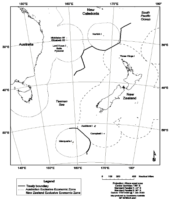
Note This map is provided as a general illustration of the lines specified in Parts 1 and 2 of Schedule 1.
Map 2 Lord Howe Island and Norfolk Island

Note This map is provided as a general illustration of the line specified in Part 1 of Schedule 1.
Map 3 Macquarie Island

Note This map is provided as a general illustration of the line specified in Part 2 of Schedule 1.
