Recognition of Representative Aboriginal/Torres Strait Islander Body 2000 (No. 10)
I, John Joseph Herron, Minister for Aboriginal and Torres Strait Islander Affairs, acting under subsection 203AD(1) of the Native Title Act 1993, recognise the Goldfields Land Council Aboriginal Corporation as the representative Aboriginal/Torres Strait Islander body for the area described in Schedule 1.
I am satisfied that the Goldfields Land Council Aboriginal Corporation:
(a) will satisfactorily represent persons who hold or may hold native title in the area described in Schedule 1; and
(b) will be able to consult effectively with Aboriginal peoples and Torres Strait Islanders living in that area; and
(c) satisfactorily performs its existing representative body functions; and
(d) would be able to perform satisfactorily the functions of a representative body.
This recognition takes effect on 1 July 2000.
Dated 27 June 2000
JOHN HERRON
Schedule 1 Description of area (Goldfields)
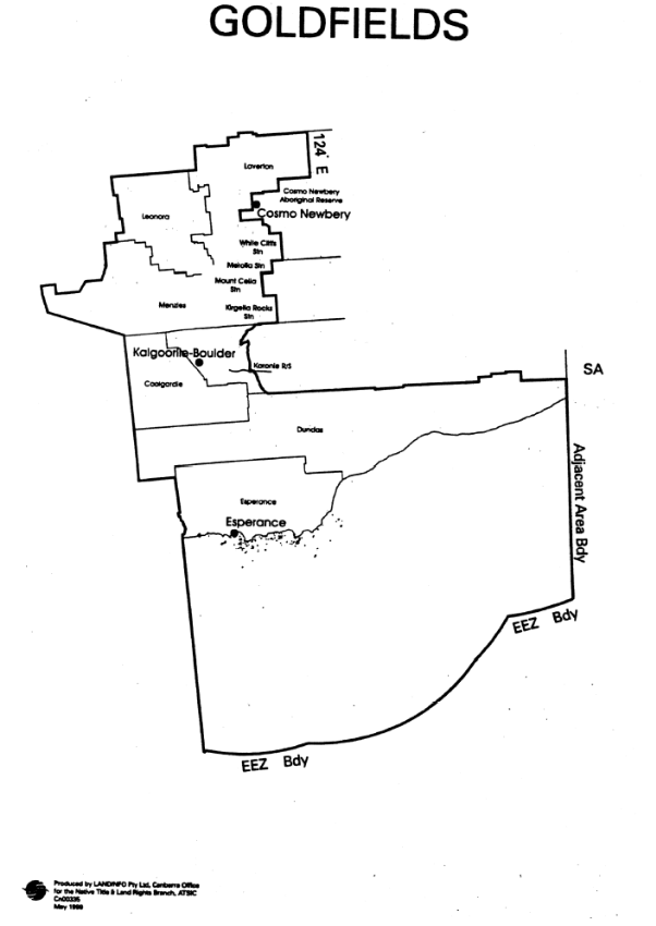
- The area is the area of land and waters bounded by a line commencing at the intersection of the western boundary of the 1991 Local Government Area (LGA) of Esperence and the coastline of mainland Australia, and then proceeding generally northerly along the western boundary of that LGA to its intersection with the Dundas LGA, then generally westerly and northerly along the southern and western boundaries of that LGA to its intersection with the Coolgardie LGA, then generally northerly along the western boundary of that LGA to its intersection with the Menzies LGA, then generally north-westerly and north-easterly along the western boundary of that LGA to its intersection with the Leonora LGA, then generally northerly and easterly along the western and northern boundaries of that LGA to its intersection with the Laverton LGA, then generally easterly along the northern boundary of that LGA to its intersection with longitude 124 degrees east, then south along that meridian to its intersection with the Cosmo Newbery Aboriginal Reserve, then generally westerly and southerly along the boundary of that Reserve to its intersection with White Cliffs Station, then generally southerly and westerly along the boundary of that Station to its intersection with Merolia Station, then generally southerly and westerly along the boundary of that Station to its intersection with Mount Celia Station, then generally southerly along the boundary of that Station to its intersection with Kirgella Rocks Station, then generally southerly along the boundary of that Station to its intersection with the Menzies LGA, then generally westerly along the southern boundary of that LGA to its intersection with Kurnalpi-Pinjin road, then generally south-westerly along that road to the Y junction of the road near Yowie Hill, then generally north-easterly on that road to the T junction at Six Mile Dam, then generally southerly along the road to the Karonie Railway Station, then generally east along the railway line to the T intersection at Black Cat Well, then generally south-easterly along the road to its intersection with the Dundas LGA, then generally easterly along the northern boundary of that LGA to its intersection with the Western Australian and South Australian State border, then south along that border to its intersection with the coastline of mainland Australia, then generally southerly along the Western Australian and South Australia adjacent area boundary as defined in Schedule 2 of the Petroleum (Submerged Lands) Act 1967 to its intersection with the outer limit of the exclusive economic zone of Australia (EEZ), then generally westerly along that outer limit to a point due south of the point where the line began, and then due north by a straight line to the point where the line began.
2. In this Schedule:
exclusive economic zone means the exclusive economic zone within the meaning of the Seas and Submerged Lands Act 1973.