Defence Practice Areas Amendment (Evans Head) Declaration 2014
I, David Johnston, Minister for Defence, make the following declaration.
[Signed by]
David Johnston
Minister for Defence
Defence Practice Areas Amendment (Evans Head) Declaration 2014
I, David Johnston, Minister for Defence, make the following declaration.
[Signed by]
David Johnston
Minister for Defence
Contents
2 Commencement
3 Authority
4 Schedules
Schedule 1—Amendments
Declaration of Defence Practice Areas made on 17 October 1994 under subregulation 49(1) of the Defence Force Regulations 1952 and published in Gazette No. GN 46 on 23 November 1994
This is the Defence Practice Areas Amendment (Evans Head) Declaration 2014.
This instrument commences on the day it is published in the Gazette.
This instrument is made under subregulation 49(1) of the Defence Force Regulations 1952 on the basis set out in paragraph 49(2)(b) and subregulation 49(3) of those Regulations.
Note 1: Paragraph 49(2)(b) and subregulation 49(3) of the Defence Force Regulations 1952 provide that an area of private land, or an area of sea or air, must not be declared to be a defence practice area under subregulation 49(1) of those Regulations unless it is necessary or expedient in the interests of the safety or defence of the Commonwealth to carry out on that area of land, or in that area of sea or air, a defence operation or practice of a kind specified in the declaration.
Note 2: The non‑extinguishment principle (within the meaning of the Native Title Act 1993) applies to the making of this instrument. See:
(a) paragraph 24MD(3)(a) of that Act to the extent that the making of this instrument relates to an onshore place (within the meaning of that Act); and
(b) subsection 24NA(4) of that Act to the extent that the making of this instrument relates to an offshore place (within the meaning of that Act).
Each instrument that is specified in a Schedule to this instrument is amended or repealed as set out in the applicable items in the Schedule concerned, and any other item in a Schedule to this instrument has effect according to its terms.
1 Schedule (table item 8)
Repeal the item, substitute:
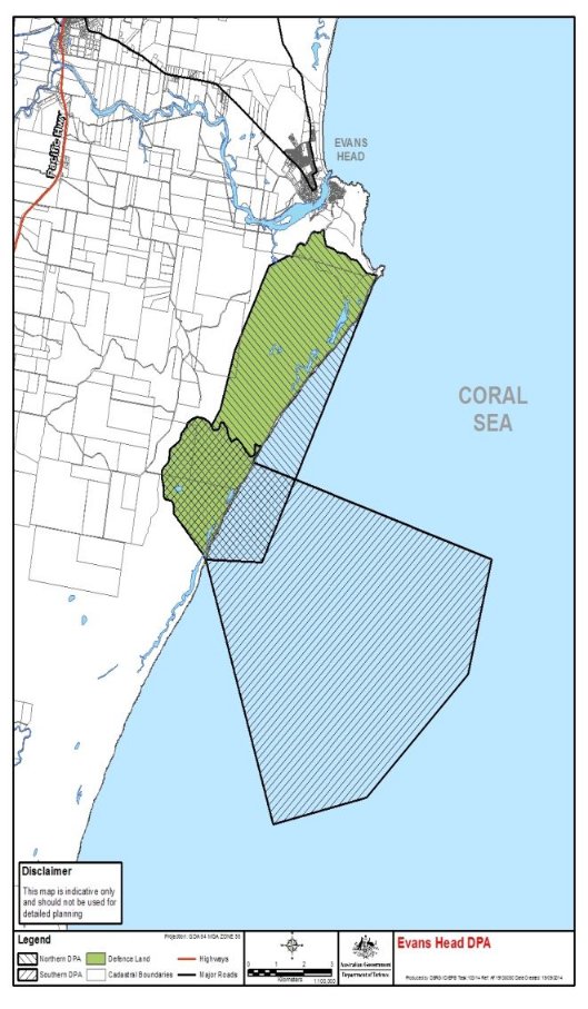
8 | Evans Head | Evans Head Air Weapons Range (EVDAWR) 8A Northern DPA (commonly known as the bombing DPA): All that area of land and airspace over that land in the parish of Evans, County of Richmond, in New South Wales, and all that area of sea and airspace over that sea being part of the South Pacific Ocean, which together are bounded by a line commencing at the high water mark at the point of latitude 29°08′25.13″S longitude 153°27′15.9″E, and running progressively: (a) along the south side of the cleared track to the point of latitude 29°08′00.89″S longitude 153°26′19.04″E; and (b) then along the fence known as the tick fence to the point of latitude 29°07′55.35″S longitude 153°25′41.25″E; and (c) then along the east side of Bombing Range Road to the point of latitude 29°08′07″S longitude 153°25′24.47″E; and (d) then to the point of latitude 29°08′06.42″S longitude 153°25′19.04″E; and (e) then to the point of latitude 29°08′15.97″S longitude 153°24′53.1″E; and (f) then to the point of latitude 29°09′37.33″S longitude 153°24′08.14″E; and (g) then to the point of latitude 29°10′33.63″S longitude 153°23′49.34″E; and (h) then to the point of latitude 29°10′49.19″S longitude 153°23′37.86″E; and (i) then along the east side of The Gap Road to the point of latitude 29°12′13.1″S longitude 153°22′47.86″E; and (j) then to the point of latitude 29°12′52.09″S longitude 153°23′26.7″E; and (k) then to the high water mark at the point latitude 29°12′57.36″S longitude 153°23′30.48″E; and (l) then to the point in the South Pacific Ocean of latitude 29°13′00″S longitude 153°24′45″E; and (m) then north to the start at the point of latitude 29°08′25.13″S longitude 153°27′15.9″E | Live fire surface to surface and air to surface |
|
|
|
|
|
| 8B Southern DPA (commonly known as the gunnery and rocketry DPA): All that area of land and airspace over that land in the parish of Evans, County of Richmond, in New South Wales, and all that area of sea and airspace over that sea being part of the South Pacific Ocean, which together are bounded by a line commencing on The Gap Road at the point of latitude 29°10′49.19″S longitude 153°23′37.86″E, and running progressively: (a) along the south side of the Postman Point Southern Trail to the high water mark at the point of latitude 29°11′23.84″S longitude 153°24′33.8″E; and (b) then to the point in the South Pacific Ocean of latitude 29°12′56″S longitude 153°29′49″E; and (c) then to the point in the South Pacific Ocean of latitude 29°14′46″S longitude 153°29′18″E; and (d) then to the point in the South Pacific Ocean of latitude 29°16′44″S longitude 153°27′04″E; and (e) then to the point in the South Pacific Ocean of latitude 29°17′10″S longitude 153°25″E; and (f) then to the high water mark at the point of latitude 29°12′57.36″S longitude 153°23′30.48″E; and (g) then to the point of latitude 29°12′52.09″S longitude 153°23′26.7″E; and (h) then to the point of latitude 29°12′13.1″S longitude 153°22′47.86″E; and (i) then north along the east side of The Gap Road to the start at the point of latitude 29°10′49.19″S longitude 153°23′37.86″E |
|
2 Schedule (Map No. 8)
Repeal the map, substitute: