Environment Protection and Biodiversity Conservation Regulations 2000
Subregulation 12.56(2)
DETERMINATION PROHIBITING USE OF VESSELS
ASHMORE REEF COMMONWEALTH MARINE RESERVE
I, CHARLTON CLARK, Assistant Secretary, Commonwealth Marine Reserves Branch, Parks Australia Division, Department of the Environment, delegate of the power of the Director of National Parks under subregulation 12.56(2) of the Environment Protection and Biodiversity Conservation Regulations 2000 HEREBY DETERMINE that the area of the Sanctuary Zone of Ashmore Reef Commonwealth Marine Reserve being the area specified in Schedule 1 and shown on the maps in Schedule 2 hereto, is prohibited at all times, except for:
- vessels of the Commonwealth of Australia and its agents.
Dated this 14th day of December 2013
SIGNED
......................................
Charlton Clark
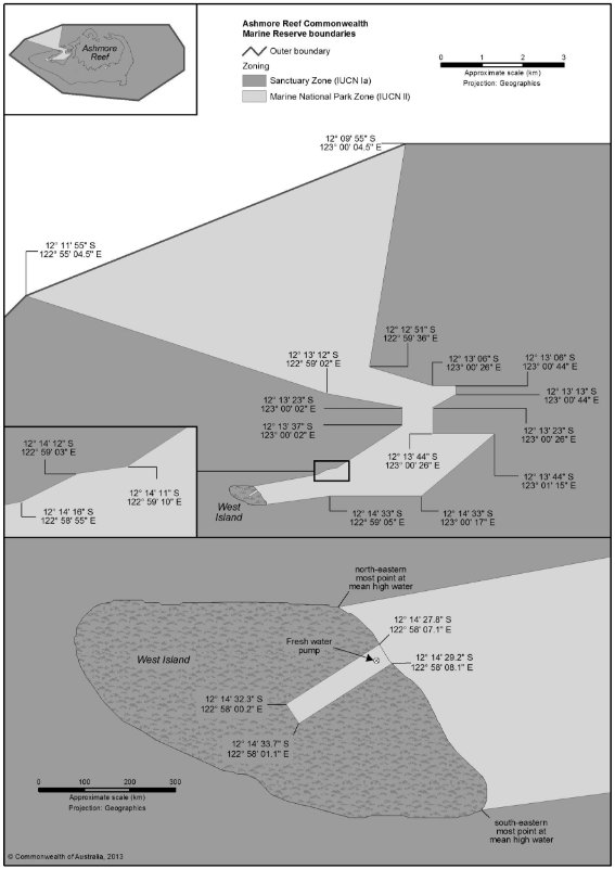
SCHEDULE 1
Sanctuary Zone (IUCN 1a): Ashmore Reef Commonwealth Marine Reserve
All that part of Ashmore Reef Commonwealth Marine Reserve (1) being outside the area bounded by the line(2 ):
(a) commencing at the point of Latitude 12° 09′ 55″ South, Longitude 123° 00′ 04.5″ East;
(b) from there southerly along the geodesic to the point of Latitude 12° 12′ 51″ South, Longitude 122° 59′ 36″ East;
(c) from there south-easterly along the geodesic to the point of Latitude 12° 13′ 06″ South, Longitude 123° 00′ 26″ East;
(d) from there east along the parallel of Latitude 12° 13′ 06″ South, to its intersection by the meridian of Longitude 123° 00′ 44″ East;
(e) from there south along that meridian to its intersection by the parallel of Latitude 12° 13′ 13″ South;
(f) from there south-westerly along the geodesic to the point of Latitude 12° 13′ 23″ South, Longitude 123° 00′ 26″ East;
(g) from there south along the meridian of Longitude 123° 00′ 26″ East, to its intersection by the parallel of Latitude 12° 13′ 44″ South;
(h) from there east along that parallel to its intersection by the meridian of Longitude 123° 01′ 15″ East;
(i) from there south-westerly along the geodesic to the point of Latitude 12° 14′ 33″ South, Longitude 123° 00′ 17″ East;
(j) from there west along the parallel of Latitude 12° 14′ 33″ South, to its intersection by the meridian of Longitude 122° 59′ 05″ East;
(k) from there westerly along the geodesic to the south-easternmost point on the coastline of West Island at mean high water;
(l) from there generally north-westerly along that high water mark to the point closest to the point of Latitude 12° 14′ 29.2″ South, Longitude 122° 58′ 08.1″ East;
(m) from there south-westerly along the geodesic to the point of Latitude 12° 14′ 33.7″ South, Longitude 122° 58′ 01.1″ East;
(n) from there north-westerly along the geodesic to the point of Latitude 12° 14′ 32.3″ South, Longitude 122° 58′ 00.2″ East;
(o) from there north-easterly along the geodesic to the point on the coastline of West Island at mean high water closest to the point of Latitude 12° 14′ 27.8″ South, Longitude 122° 58′ 07.1″ East;
(p) from there generally north-westerly along that high water mark to the north easternmost point of the West Island;
(q) from there easterly along the geodesic to the point of Latitude 12° 14′ 16″ South, Longitude 122° 58′ 55″ East;
(r) from there north-easterly along the geodesic to the point of Latitude 12° 14′ 12″ South, Longitude 122° 59′ 03″ East;
(s) from there easterly along the geodesic to the point of Latitude 12° 14′ 11″ South, Longitude 122° 59′ 10″ East;
(t) from there north-easterly along the geodesic to the point of Latitude 12° 13′ 37″ South, Longitude 123° 00′ 02″ East;
(u) from there north along the meridian of Longitude 123° 00′ 02″ East, to its intersection by the parallel of Latitude 12° 13′ 23″ South;
(v) from there westerly along the geodesic to the point of Latitude 12° 13′ 12″ South, Longitude 122° 59′ 02″ East;
(w) from there north-westerly along the geodesic to the point of Latitude 12° 11′ 55″ South, Longitude 122° 55′ 04.5″ East;
(x) from there north-easterly along the geodesic to the point of commencement.
Notes:
(1) As described in the Commonwealth of Australia Gazette GN46 of 17 November 2004
(2) All geographic coordinates are expressed in terms of the Geocentric Datum of Australia 1994 (GDA94) as described in the Commonwealth of Australia Gazette GN35 of 6 September 1995.
SCHEDULE 2 - MAPS OF AREA CLOSED TO THE PUBLIC