Environment Protection and Biodiversity Conservation Regulations 2000
Subregulation 12.56(2)
DETERMINATION PROHIBITING USE OF RECREATIONAL VESSELS WITH FISHING GEAR IN USE
PART OF THE CORAL SEA COMMONWEALTH MARINE RESERVE –
AREA OF THE FORMER LIHOU REEF NATIONAL NATURE RESERVE AND CORINGA-HEARLD NATIONAL NATURE RESERVE
I, CHARLTON CLARK, Assistant Secretary, Commonwealth Marine Reserves Branch, Parks Australia Division, Department of the Environment, delegate of the power of the Director of National Parks under subregulation 12.56(2) of the Environment Protection and Biodiversity Conservation Regulations 2000, HEREBY DETERMINE that the areas of the former Lihou Reef National Nature Reserve and Coringa-Herald National Nature Reserve declared by proclamation on 16 August 1982 and revoked by Proclamation that took effect on 17 November 2012, being the areas specified in the Schedule hereto, are areas of water where use of the following class of vessels:
- vessels that are being used in connection with recreational fishing and have fishing gear on board and in use,
is prohibited at all times.
In this determination:
(a) recreational fishing means fishing other than commercial fishing; and
(b) fishing gear means equipment, designed to be used to attract or take fish or other aquatic animals.
Dated this 14th day of December 2013
SIGNED
………………………………….
Charlton Clark
SCHEDULE
PART OF THE CORAL SEA COMMONWEALTH MARINE RESERVE
The area of the former Lihou Reef National Nature Reserve:
All of that area in the Coral Sea bounded by the line(1):
(i) commencing at the point of latitude 17° 54′ 00″ S, longitude 151° 08′ 00″ E;
(ii) from there north along the meridian of longitude 151° 08′ 00″ E to its intersection by the parallel of latitude 17° 21′ 00″ S;
(iii) from there north-easterly along the geodesic to the point of latitude 16° 57′ 00″ S, longitude 151° 54′ 00″ E;
(iv) from there east along the parallel of latitude 16° 57′ 00″ S to its intersection by the meridian of longitude 152° 20′ 00″ E;
(v) from there south along that meridian to its intersection by the parallel of latitude 17° 27′ 00″ S; and
(vi) from there south-westerly along the geodesic to the point of commencement.
Notes:
- Geographic coordinates are expressed in terms of the Geocentric Datum of Australia 1994 (GDA94) as described in the Commonwealth of Australia Gazette GN35 of 6 September 1995.

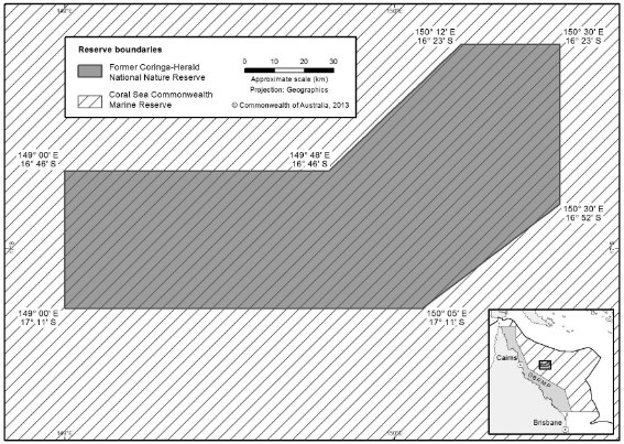
The area of the former Coringa-Herald National Nature Reserve:
All of that area in the Coral Sea bounded by the line(1):
(i) commencing at the point of latitude 17° 11′ 00″ S, longitude 150° 05′ 00″ E;
(ii) from there west along the parallel of latitude 17° 11′ 00″ S to its intersection by the meridian of longitude 149° 00′ 00″ E;
(iii) from there north along that meridian to its intersection by the parallel of latitude 16° 46′ 00″ S;
(iv) from there east along that parallel to its intersection by the meridian of longitude
149° 48′ 00″ E;
(v) from there north-easterly along the geodesic to the point of latitude 16° 23′ 00″ S, longitude 150° 12′ 00″ E;
(vi) from there east along the parallel of latitude 16° 23′ 00″ S to its intersection by the meridian of longitude 150° 30′ 00″ E;
(vii) from there south along that meridian to its intersection by the parallel of latitude 16° 52′ 00″ S; and
(viii) from there south-westerly along the geodesic to the point of commencement.
Notes:
Geographic coordinates are expressed in terms of the Geocentric Datum of Australia 1994 (GDA94) as described in the Commonwealth of Australia Gazette GN35 of 6 September 1995.